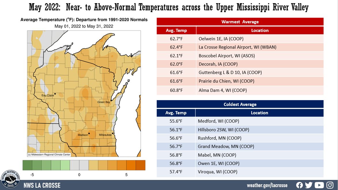
| During May 2022, temperature anomalies ranged from near-normal to 2°F above-normal across the Upper Mississippi River Valley. Monthly average temperatures ranged from 55.6°F at Medford, WI (COOP) to 62.7°F at Oelwein, IA (COOP). The hottest temperature was 97°F at Boscobel Airport, WI (ASOS) on May 12 and the coldest temperature was 24°F at Sparta Fort McCoy Airport on May 4. |
 |
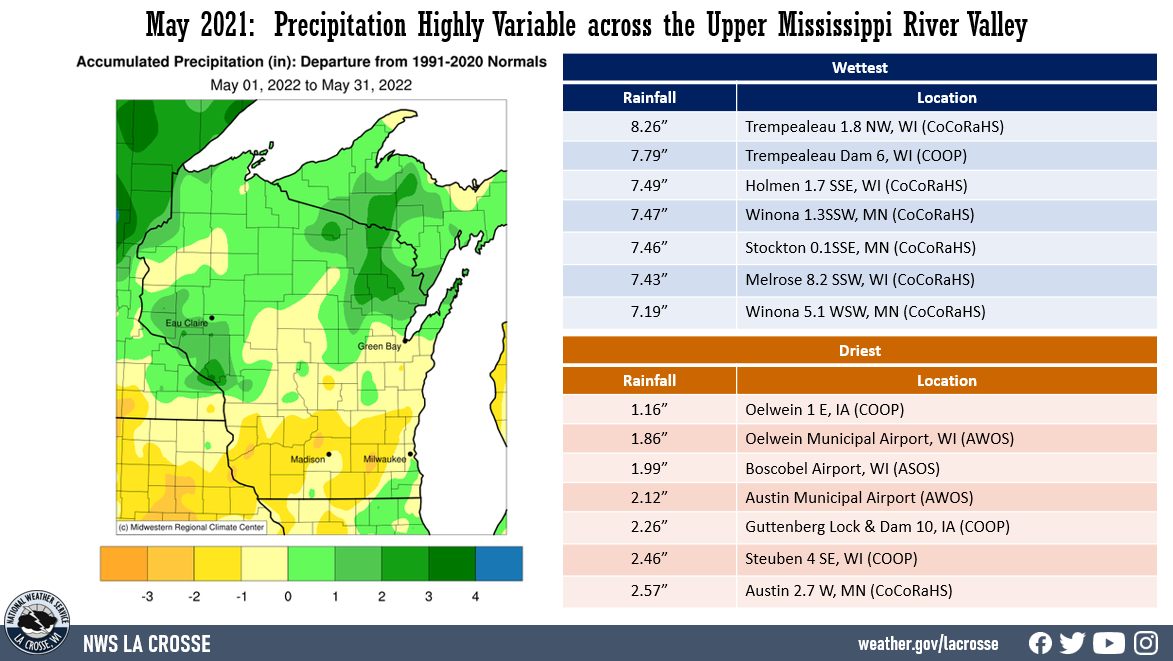
| Rainfall anomalies ranged from near-normal to up to 3" drier-than-normal south of Interstate 90 and from near-normal to 4” wetter-than-normal across the remainder of the Upper Mississippi River Valley. Precipitation totals ranged from 1.16” at Oelwein, IA (COOP) to 8.26” just northwest of Trempealeau, WI (CoCoRaHS). The wettest 1-day rainfall was 3.88" just south southwest of Winona, MN (CoCoRaHS). This rainfall fell from 7 AM on May 19 to 7 AM on May 20. |
 |
It was an active month with severe weather. There were 48 Severe Thunderstorm Warnings and 2 Tornado Warnings issued during May. This was the 6th most severe weather warnings in a May. It was the most since 2017 when there was 56 warnings (all Severe Thunderstorm Warnings). The most severe weather warnings in a May was 72 in 2013 (56 Severe Thunderstorm Warnings and 16 Tornado Warnings). The least was 0 severe weather warnings in 1990. The 1987-2022 average is 21 warnings (19 Severe Thunderstorm Warnnings and 2 Tornado Warnings).
Below are the May 2022 climate summaries for La Crosse, WI and Rochester, MN.
La Crosse, WI
May 2022 - Warmer and Slightly Drier than Normal in La Crosse, WI
|
...May 2022 Highlights...
Temperatures...Warmer than Normal
- The average temperature was 62.4°F. This was 1.4°F warmer than the 1991-2020 normal of 61°F. Warmest since 2018 (67.6°F - 2nd warmest May).
- The average high temperature was 72.6°F. This was 0.6°F warmer than the 1991-2020 normal of 72°F. Warmest since 2018 (78.2°F - 5th warmest May).
- The average low temperature was 52.2°F. This was 2.1°F warmer than the 1991-2020 normal of 49.8°F. Warmest since 2018 (57°F - 2nd warmest May).
|
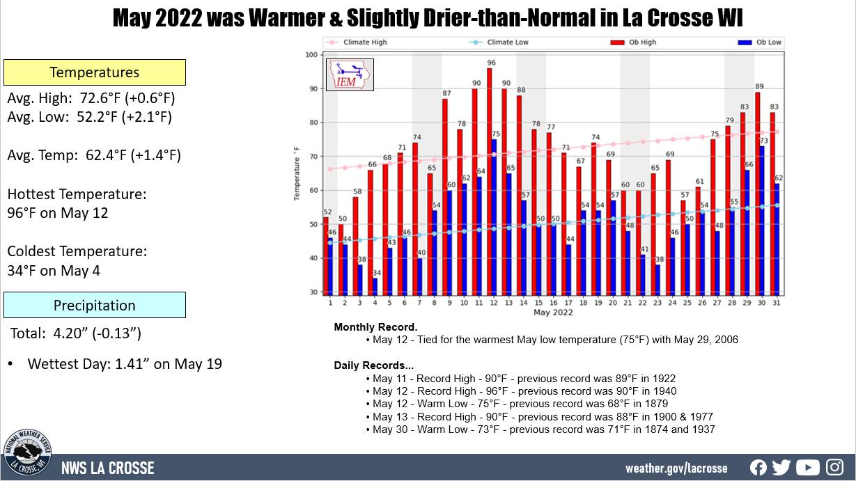 |
- The hottest temperature was 96°F on May 12. This tied May 27, 1874, May 19, 1934, & May 29, 2018, for the 5th warmest high temperature during the month of May.
- The warmest low temperature was 75°F on May 12. This tied May 29, 2006 for the warmest May low temperature. There was 2 low temperatures this May which were among the 9 warmest May lows. The other one was on May 30 when the low temperature was 73°F. This was tied for the 6th warmest May low temperature with May 28, 1874; May 4, 1949; and May 28, 2006.
- The coldest high temperature was 50°F on May 2.
- The coldest low temperature was 34°F on May 4.
- With a daily average temperature of 85.5°F on May 12, this became the 2nd warmest daily average temperature in May. Only May 31, 1934, was warmer with an average temperature of 88°F.
- There were 3 consecutive days with record temperatures (May 11-13). This tied for the 4th longest stretch of May days with record temperatures. The longest stretch for May was 5 days from May 17-21, 1934.
- From May 11-13, La Crosse Regional Airport had an average temperature of 80°F. This was the 5th warmest 3-day stretch in May. Out of the ten warmest, it was the earliest of any of the others. 7 out of the 10 occurred after May 20th.
- There was 3 days with temperatures at or above 90°F. The long-term average is 1-day in May.
Rainfall...Slightly Drier than Normal
- The total of 4.20" of rain fell which was 0.13" drier than the 1991-2020 normal of 4.33".
- The wettest day was on May 19 when 1.41" of rain fell.
Miscellaneous...
- On May 10, a severe thunderstorm produced hail up to quarter-size hail 5 miles north northeast of New Amsterdam.
- On the evening May 19, multiple rounds of severe thunderstorms (5 Severe Thunderstorm Warnings) produced quarter to golf-ball sized hail (largest in Holmen) in La Crosse County. Street flooding was reported in La Crosse. Finally, there was a 62 mph wind gust recorded at La Crosse Regional Airport.
- On the morning of May 20, pea size hail was reported between Holmen and French Island.
- On the morning of May 23, areas of frost was seen in La Crosse County.
...Records...
Monthly...
- May 12 - Tied for the warmest May low temperature (75°F) with May 29, 2006.
Daily...
- May 11 - Record High - 90°F - previous record was 89°F in 1922
- May 12 - Record High - 96°F - previous record was 90°F in 1940
- May 12 - Warm Low - 75°F - previous record was 68°F in 1879
- May 13 - Record High - 90°F - previous record was 88°F in 1900 & 1977
- May 30 - Warm Low - 73°F - previous record was 71°F in 1874 and 1937
...Looking ahead to June...
- The normal high temperature in La Crosse rises from 78°F on June 1st to 85°F on the 30th. The normal low temperature rises from 56°F on the 1st to 64°F by the end of the month. The normal mean temperature for the month is 71.0°F. La Crosse’s hottest June occurred back in 1993 with an average temperature of 76.5°F, and their coldest June occurred in 1969 with an average temperature of 61.4°F.
- For June, the hottest temperature ever recorded was 102°F on June 20, 1933, and June 21, 1988, and the coldest temperature was 33°F on June 1, 1897.
- The average precipitation for June is 5.08". The wettest June occurred in 1899 when 11.56" of precipitation fell. The driest June occurred in 1910 when 0.37" of precipitation fell. The wettest June day was 4.50" on June 18, 2011. Normally, there are 7 days with thunderstorms.
Rochester, MN
May 2022 - Warmer and Slightly Drier than Normal in Rochester, MN
|
...May 2022 Highlights...
Temperatures...Warmer than Normal
- The average temperature was 59.3°F. This was 1.7°F warmer than the 1991-2020 normal of 57.6°F. Warmest since 2018 (64.1°F - 3rd warmest May).
- The average high temperature was 69.7°F. This was 1.7°F warmer than the 1991-2020 normal of 68°F. Warmest since 2018 (74.8°F - 8th warmest May).
- The average low temperature was 48.8°F. This was 1.7°F warmer than the 1991-2020 normal of 57.6°F. Warmest since 2018 (53.5°F - warmest May).
|
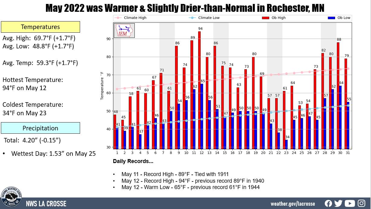 |
- The hottest temperature was 94°F on May 12. This tied May 6, 1934, May 29, 1934, May 19, 2009, & May 24, 2010, for the 10th warmest high temperature during the month of May.
- The warmest low temperature was 65°F on May 12.
- The coldest high temperature was 45°F on May 2.
- The coldest temperature was 34°F on May 23.
- With a daily average temperature of 73.5°F on May 12, this tied May 19, 1911, & May 14, 2007, for the 9th warmest daily average temperature in May. The warmest May daily average temperature was 83.5°F on May 31, 1934, and May 29, 2006.
Rainfall...Slightly Drier than Normal
- The total of 4.20" of rain fell which was 0.15" drier than the 1991-2020 normal of 4.35".
- The wettest day was on May 25 when 1.53" of rain fell.
Miscellaneous...
- During the evening of May 10, a severe thunderstorm produced a 76 mph wind gust at Rochester International Airport.
- On May 11, several severe thunderstorms moved through Olmsted County. These prompted 4 Severe Thunderstorm Warnings. One of these storms produced golf-ball size hail near Potsdam.
- During the afternoon and evening of May 19, 3 severe thunderstorms moved through Olmsted County. One of these storms produced quarter (1" diameter) to ping pong size hail (1.5" diameter) between Rochester International Airport and Rochester.
- On the morning of May 23, areas of frost was seen in Olmsted County.
- On May 31, a severe thunderstorm produced a 67 mph wind gust at Rochester International Airport.
...Records...
Daily...
- May 11 - Record High - 89°F - Tied with 1911
- May 12 - Record High - 94°F - previous record 89°F in 1940
- May 12 - Warm Low - 65°F - previous record 61°F in 1944
...Looking ahead to June...
- The normal high temperature in Rochester rises from 74°F on June 1st to 80°F by the end of the month. The normal low temperature rises from 53°F on the 1st to 61°F by the end of the month. The normal mean temperature for the month is 67.5°F. Rochester’s hottest June occurred back in 1933 with an average temperature of 73.9°F, and their coldest June occurred in 1969 with an average temperature of 59.6°F.
- For June, the hottest temperature ever recorded was 105°F on June 27, 1934, and the coldest temperature was 31°F on June 9, 1937. There are typically 2 days with temperatures at or above 90°F.
- The average precipitation for June is 5.35". The wettest June occurred in 2000 when 12.51" of precipitation fell. The driest June occurred in 1910 when a trace of precipitation fell. The wettest June day was 4.90" on June 28, 2019. Normally, there are 8 days with thunderstorms.

