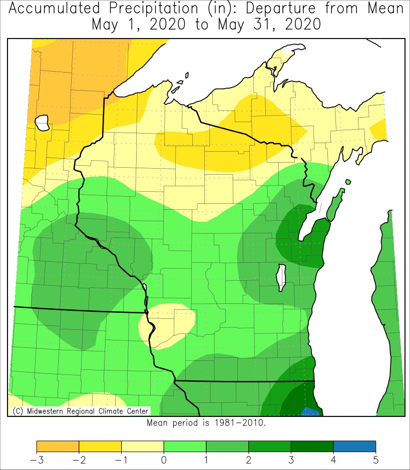
During May 2020, temperatures were near-normal north of Interstate 90 and they were up to 3°F colder-than-normal along and south of Interstate 90. Rainfall was generally above normal across the Upper Mississippi River. The only exceptions to this was in eastern Allamakee County in northeast Iowa, and Crawford, northern Grant, Richland, Taylor, and Vernon counties in Wisconsin where rainfall totals were up to 1" drier-than-normal.
 |
 |
| Temperature Anomalies |
Precipitation Anomalies |
The following are the climate summaries for La Crosse WI and Rochester MN.
La Crosse, WI
...May 2020 was Slightly Cooler and Drier in La Crosse WI...
...May Highlights...
- While temperatures averaged near-normal (59.5°F or 0.2°F colder than the 1981-2010 normal) in May 2020, there was an extended period of cold weather from May 4 through May 13. Temperatures averaged 48.6°F during this period which was 8.9°F below normal. This included a record low temperature on May 12. A freeze occurred on this morning.
- The warmest stretch of weather occurred from May 23 through May 28. High temperatures ranged from the mid-70s to mid-80s. This included the first 80-degree or higher temperature of 2020 on May 24. This was the 12th latest date in a calendar year. This was the latest date since 1983 (June 8). The latest date was June 16 in 1883.
- Measurable rain (0.01" or more) fell on 13 days. This amounted to 3.28" which was 0.24 inches drier than the 1981-2010 normal (3.52"). This was the driest May since 2014 (2.46"). 7 out of the last 9 Mays have been wetter-than-normal. The wettest day was May 25 (Memorial Day) when 1.08" of rain fell. This was the second wettest Memorial Day. The wettest (1.13") occurred just last year.
- While no snow fell at La Crosse Regional Airport or the city of La Crosse, a dusting of snow fell on surrounding ridge tops on May 10. This was the first May snow in the La Crosse area since May 1, 2017.
...Records...
- A record low temperature was broken on May 12 (30°F). The previous record was 31°F in 1967.
...Looking ahead to June...
- The normal high temperature rises from 76 degrees on the 1st to 84°F on the 30th. The normal low temperature rises from 54°F on the 1st to 63°F by the end of the month. The mean temperature for the month is 69.2°F. La Crosse warmest June occurred back in 1993 when the average temperature was 76.5°F. The coldest June occurred in 1969 when the average temperature was 61.4°F.
- The average precipitation for June is 4.34". The wettest June occurred in 1899 when 11.56" of precipitation fell. The driest June occurred in 1910 when 0.37" of precipitation fell. Normally, there are 8 days with thunderstorms.
Rochester, MN
...May 2020 Was Colder and Wetter-than-Normal in Rochester MN...
...May Highlights...
- Rochester International Airport average 1.9°F colder than the 1981-2010 normal of 58.1°F. 3 out of the past 4 Mays have averaged colder-than-normal.
- The coldest period was from May 4 through May 13 when temperatures averaged just 46°F. This was 9.7°F colder-than-normal. This included a record cold high temperature on May 10. A freeze occurred on May 9.
- The warmest weather occurred from May 24 through May 28. High temperatures during this time period were near 80 degrees. This included the first 80°F or greater temperature of 2020 on May 26. This tied 1919 for the 12th latest date in a calendar year. This was the latest date since 2005 (June 1). The latest date is June 9 in 1888.
- Measurable rain fell on 13 days. This amounted to 5 inches which was 1.37" wetter-than-normal (3.63"). This followed the wet trend over the past decade. Since 2011, 8 of the 10 Mays have been wetter-than-normal. The wettest day was Memorial Day (May 25) when 0.98" of rain fell.
- A trace of snow fell on May 10. This was the first May snow since 2013 when 14.5 inches of snow fell on May 2-3.
...Records...
- On May 10, a record cold high temperature (46°F) was broken. The previous record was 48°F in 1892, 1933, and 1948.
- On May 10, a trace of snow fell. This tied 1946, 1960, 1966, and 1969 for the most snow on this date.
...Looking ahead to June...
- The normal high temperature rises from 74°F on the 1st to 81°F on the 30th. The normal low temperature rises from 53°F on the 1st to 61°F by the end of the month. The mean temperature for the month is 67.6°F. Rochester warmest June occurred back in 1933 when the average temperature was 73.9 °F. The coldest June occurred in 1969 when the average temperature was only 59.6°F.
- The average precipitation for June is 4.68". The wettest June occurred in 2000 when 12.51" of precipitation fell. The driest June occurred in 1910 when a trace of precipitation fell. Normally, there are 8 days with thunderstorms.

