Charles City Tornado:
 |
 |
| This picture was taken by the Floyd County sheriff (L. L. Lane) at his spotter position on Highway 14. It shows the tornado when it was 2 miles southwest of Charles City. (A special thanks to Mark Wicks from The Charles City Press for providing us a picture of the tornado.) | Multiple vortices, located in the Charles City tornado, produced spiral ground markings on a field 4 miles northeast of Charles City. From these vortices and the speed of the tornado, the Weather Bureau estimated the tornadic winds to be 528 mph. However recent wind studies and Doppler on Wheels observations indicate that these winds were more likely in the 200 to 300 mph range. (Picture was taken by Larry Niebergall) |
Damage Pictures from the Charles City Tornado: (A special thanks to Jeff Sisson who provided us with the pictures below. You can read Jeff Sisson's personal account of the tornado from the following link.)
 |
 |
 |
| Aerial view of the tornado's damage | Just south of the Cedar River looking north | The north end of Charles City just a few blocks West of The Oliver Plant |
 |
 |
 |
| The Hauser Funeral Home at the corner of Blunt and Milwaukee | Gibson's Department Store at the southeast corner of Blunt and Main | McKinley School Building |
 |
 |
 |
| The north end of Charles City | The 700 block of Main Street looking south | Iowa Public Service Office across from Central Park |
 |
 |
 |
| The First Baptist Church on the northeast corner of Clark and Milwaukee | The First Baptist Church | Corner of 8th and Hildreth |
 |
 |
 |
| Jacobs Elevator | First Methodist Church on the northeast corner of Wisconsin and Kelly | The Manual Arts Building taken from Wisconsin Street |
 |
 |
 |
| First Christian Church on Wisconsin Street | Cedar Terrace South near Brantingham Bridge | St. Charles Hotel northwest corner of Wisconsin and Blunt |
 |
 |
 |
| Destroyed cars at Lions Field | Car destroyed by falling debris | McKinley School left, Salsbury Labs right from Brantingham Bridge |
 |
 |
 |
| South end of town where tornado first struck | South side of Cedar River where tornado crossed | Taken just west of the Oliver Tractor Plant |
 |
||
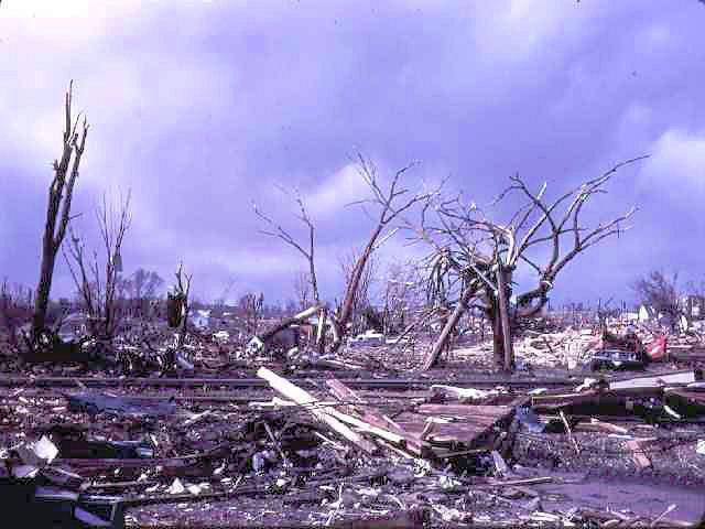
| Typical scene on the north end of town |
Below are additional damage from the Charles City Tornado damage taken by Brad Howell. He took these photos on May 18, 1968. To read his own personal account of this tornado click here. He also sent us a digital copy of his scrap book of this tornado.
 |
 |
 |
| Smashed cars were held here at Lions Field for the insurance companies. | Smashed cars were held here at Lions Field for the insurance companies. | Smashed cars were held here at Lions Field for the insurance companies. |
 |
 |
 |
| This is where my brother Rick was during the tornado. Looking southwest from the intersection of Main and 11th street. | This is looking northeast from Riverside Drive on the north side of the river. | A view of the east side of Cedar Street looking southeast in the 500 block. |
 |
 |
 |
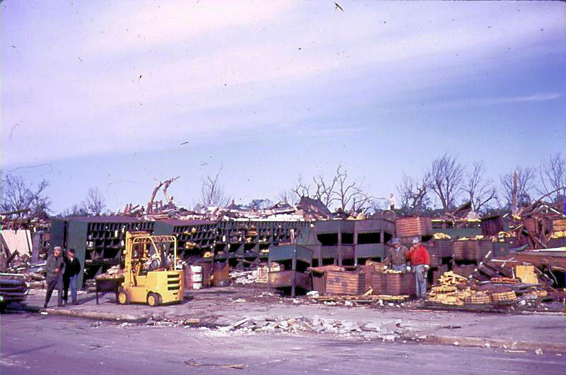
| Looking North on Riverside between Wisconsin and Milwaukee. | Looking southeast at the back of what is left of the IGA store near Clark and Wisconsin. | Looking north from Kelly and Milwaukee. |
 |
 |
 |
| Looking southeast from Main Street at Gibson's Discount Store corner of Blunt. | Looking south in the 700 block of Jackson Street. | Kelly and Main looking west on the south side of Central Park. |
 |
 |
 |
| Looking south in the 500 block of north Jackson Street | Looking west toward Main Street from apartment 49 in Cedar Terrace complex. Salisbury building is on the far left. | This is the 1st building counting from southwest clockwise on Kneisel Circle looking northeast at the southwest side of the quadruplex apartment. I was in the northeast side apartment 49. |
 |
 |
 |
| This is what was left of the gas station on the south side of Gilbert Street at Hildreth Looking south. | Looking south from Gilbert at gas station on corner of Hildreth. This was directly across the street south from Cedar Terrace. | Looking straight north from Clark near Milwaukee at the First Methodist Church. |
 |
 |
 |
| The tractor dealership on the north end of town. | A gas station near McKinley School. | Looking north from Blunt at Milwaukee. |
 |
 |
|
| Buildings in 500 block of north Wisconsin looking west toward Main. | Looking south from Johnson and Charles Street at our house at 100 Charles Street. Our house was unaffected by the tornado. |

