Overview
|
A powerful spring storm system brough heavy snow and strong winds to areas west of the Mississippi River during the morning of March 5. Moderate rainfall preceded the snow during the day on March 4, with most locations seeing 1 to 1.50" of total precipitation (rain and snow). The day started warm, but as the center of the low pressure system tracked by, winds quickly switched to the north and increased in intensity, brining colder air back into the region. The strongest winds and heaviest snow fell west of the Mississippi River, leading to periods of blizzard conditions across exposed locales. The worst conditions were west of a Rochester, MN to Waterloo, IA line were multiple roads were closed and numerous accidents reported. |
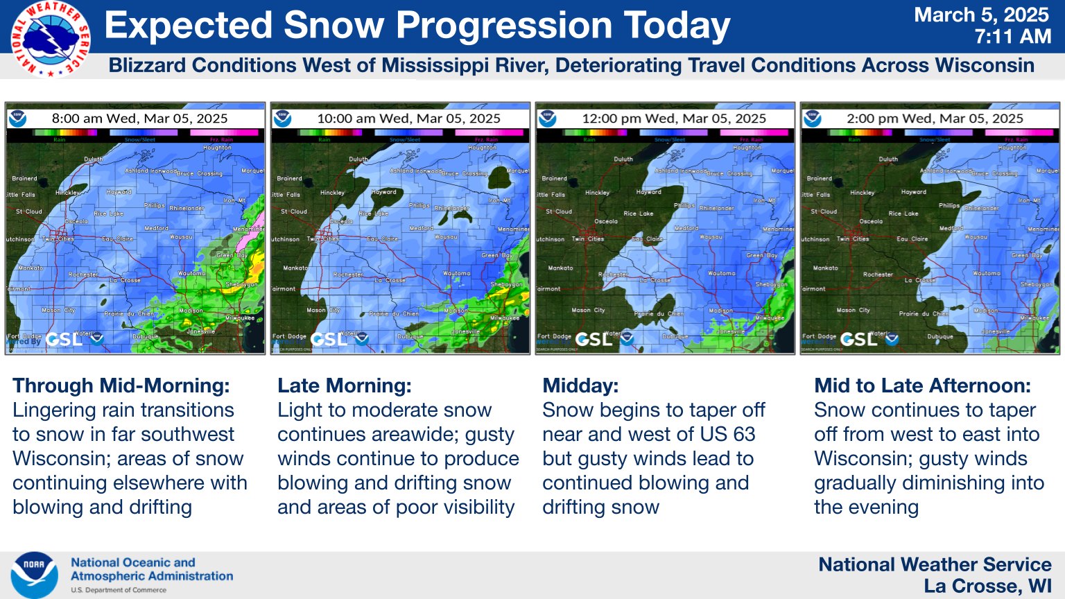
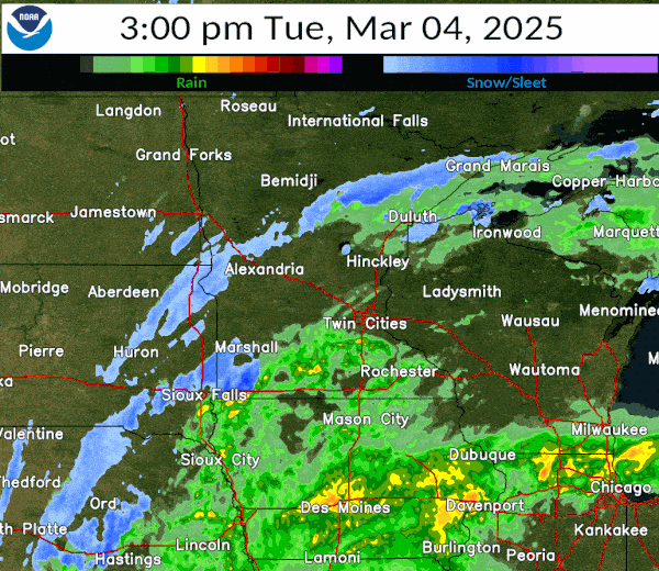 Radar loop and precipitation type from March 5-6 2025 |
Snow Reports
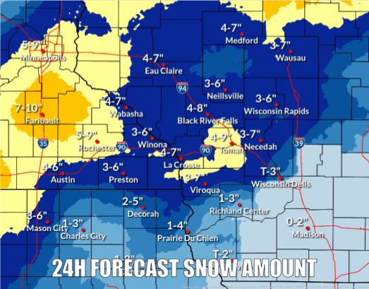
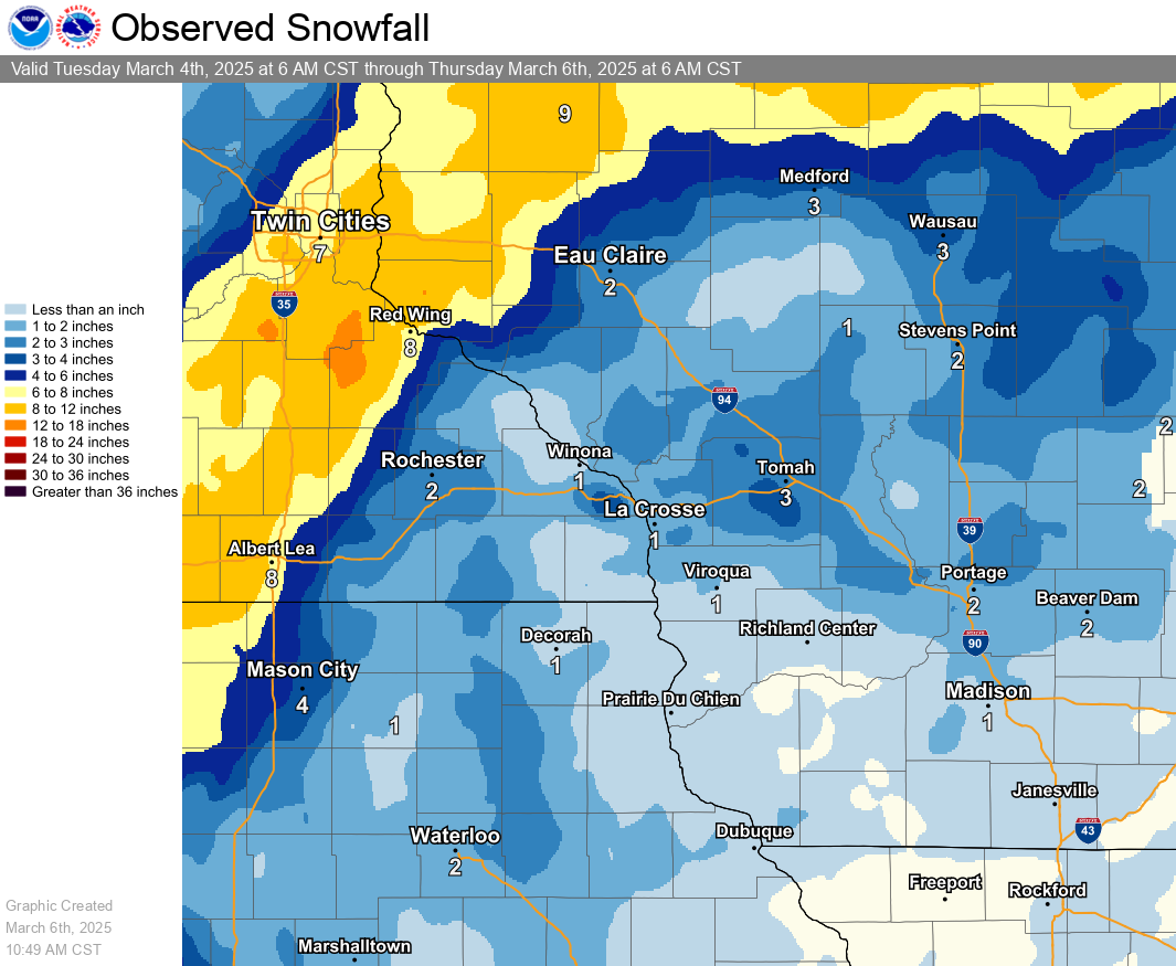 Total snowfall from March 5-6, derived from reports during the event. |
Location                     Amount    Time/Date

...Iowa...

...Allamakee County...
Harpers Ferry 6.4 SSW        1.0 in    0700 AM 03/06
Postville 5.5 NE             0.2 in    0700 AM 03/06

...Chickasaw County...
New Hampton 0.4 SW           1.7 in    0700 AM 03/06
Fredericksburg 0.3 S         0.6 in    0800 AM 03/05
Ionia 2W                     0.3 in    0700 AM 03/05

...Clayton County...
Elkader 6.8 WSW              1.2 in    0630 AM 03/06
Guttenberg Dam 10            1.0 in    0600 AM 03/06
Monona 0.2 WNW               0.3 in    0630 AM 03/06
Strawberry Point             0.5 in    0700 AM 03/05

...Fayette County...
Waucoma 1 WNW                4.0 in    0700 AM 03/06
Oelwein 1 E                  2.3 in    0630 AM 03/06
Fayette                      1.6 in    0700 AM 03/06

...Floyd County...
Charles City                 1.0 in    0700 AM 03/05
Nashua 2SW                    T in     0700 AM 03/05

...Mitchell County...
St Ansgar                    3.4 in    0630 AM 03/06
Osage                        2.0 in    0700 AM 03/06


...Winneshiek County...
7 ENE Decorah                0.9 in    0850 AM 03/05

...Minnesota...

...Dodge County...
1 NE Kasson                  6.5 in    1226 PM 03/05
Mantorville                  5.0 in    0521 AM 03/05
Mantorville 1.9 ESE          4.6 in    0700 AM 03/06
Hayfield 0.3 SSE             3.4 in    1130 AM 03/05

...Fillmore County...

Ostrander                    2.0 in    1058 AM 03/05
2 WSW Fillmore               1.6 in    1030 AM 03/05
Wykoff 3.1 NW                1.6 in    0700 AM 03/06
Mabel                        1.5 in    0700 AM 03/06
Lanesboro 0.2 SSW            1.4 in    0600 AM 03/06
Chatfield 9.0 ESE            1.2 in    0700 AM 03/06
Spring Valley 0.9 NNW        0.5 in    0700 AM 03/05

...Houston County...
Brownsville                  1.0 in    0121 PM 03/05
La Crescent 5.6 S            0.8 in    0752 AM 03/05
Caledonia 5.4 S              0.5 in    0800 AM 03/05
1 ENE Mound Prairie          0.1 in    0700 AM 03/05
Hokah 4 NW                   0.1 in    0700 AM 03/05
Caledonia                    0.1 in    0600 AM 03/05

...Mower County...
Waltham 2.0 SE               4.0 in    0800 AM 03/05
Austin 2.4 W                 3.9 in    0655 AM 03/05
4 WSW Austin                 3.5 in    0700 AM 03/05
Austin Waste Water Treatment 2.0 in    0700 AM 03/05
Austin 1.1 ESE               1.5 in    0700 AM 03/05
Austin 1.9 ENE               1.0 in    0830 AM 03/05

...Olmsted County...
1 SSW Rochester              4.0 in    0941 AM 03/05
2 NE Rochester               4.0 in    0530 AM 03/06
Rochester 4.7 N              3.5 in    0700 AM 03/05
4 N Rochester                3.1 in    1124 AM 03/05
2 NNW Rochester              3.0 in    0700 AM 03/06
Rochester Intl Airport       2.6 in    0216 PM 03/05
Stewartville 4.3 E           2.5 in    0600 AM 03/06
Rochester 3.9 ESE            2.5 in    0700 AM 03/06
Chatfield 2.7 NNW            2.2 in    0800 AM 03/05
4 SE Douglas                 2.0 in    0700 AM 03/05
Byron 5.5 SE                 1.5 in    0710 AM 03/05
5 SW Elba                    1.2 in    0126 PM 03/05

...Wabasha County...
Lake City 0.7 SE             2.8 in    0800 AM 03/05
2 ESE Wabasha                2.0 in    1043 AM 03/05
Zumbro Falls 3.5 SSW         1.4 in    0715 AM 03/05

...Winona County...
La Crescent 4.0 NNW          1.7 in    0700 AM 03/06
Altura 5w                    1.5 in    0700 AM 03/05
1 NNW Winona                 1.0 in    1227 PM 03/05
Lewiston                     1.0 in    1058 AM 03/05
2 NNW Wilson                 1.0 in    0821 AM 03/05
La Crescent 4.0 NNW          0.8 in    0710 AM 03/05
Winona 6.9 ESE               0.7 in    0700 AM 03/05
Winona                       0.5 in    0938 AM 03/05
Winona 2.0 ESE               0.6 in    0700 AM 03/05
Winona 1.9 ESE               0.3 in    0740 AM 03/05
4.2 N Rollingstone           0.2 in    0719 AM 03/05

...Wisconsin...

...Adams County...
Strongs Prairie              1.5 in    1133 AM 03/05
Oxford 4.0 W                 1.0 in    0700 AM 03/06
0.6 W Friendship              T in     0700 AM 03/05

...Buffalo County...
Mondovi                      2.3 in    1151 AM 03/05
Alma                         2.0 in    1230 PM 03/05
7 NW Urne                    1.5 in    1148 AM 03/05

...Clark County...
Thorp 10.1 S                 3.0 in    0600 AM 03/06
4 SSE Riplinger              2.0 in    0146 PM 03/05
Thorp 10.1 S                 0.5 in    0600 AM 03/05

...Crawford County...
Eastman                      0.5 in    0223 PM 03/05

...Jackson County...
Melrose 3.6 W                2.0 in    0700 AM 03/06
Black River Falls            0.5 in    0805 AM 03/05

...Juneau County...
1.0 E Mauston                3.0 in    0630 AM 03/06
New Lisbon                   2.8 in    1029 AM 03/05

...La Crosse County...
NWS La Crosse                2.3 in    1203 PM 03/05
Onalaska 1.9 E               2.0 in    0700 AM 03/06
La Crosse 1.5 SSE            2.0 in    0700 AM 03/06
Coon Valley 4.5 NNW          1.9 in    0700 AM 03/06
Onalaska 0.5 WSW             1.3 in    0700 AM 03/06
4 SW Mindoro                 1.0 in    1136 AM 03/05
1 NNW Holmen                 0.5 in    1023 AM 03/05
1 WSW West Salem             0.5 in    1009 AM 03/05
La Crosse 4NNW               0.3 in    0730 AM 03/05

...Monroe County...
Warrens 4.7 WSW              4.0 in    0700 AM 03/06
Cataract                     4.0 in    0122 PM 03/05
Cashton 3 NNW                2.8 in    0750 AM 03/06
Tomah                        1.5 in    0208 PM 03/05
Sparta                       1.0 in    1114 AM 03/05
Tomah 7.5 SSW                0.5 in    0800 AM 03/05

...Richland County...
Richland Center 4 N            T in    0800 AM 03/05

...Taylor County...
Westboro                     4.5 in    0739 AM 03/05
Medford 0.8 ENE              2.4 in    0700 AM 03/06
4 E Perkinstown              1.5 in    1153 AM 03/05
2 N Dorchester               1.5 in    1138 AM 03/05

...Trempealeau County...
Ettrick 4.0 WNW              3.1 in    0730 AM 03/06
2 SSE Elk Creek              2.5 in    1236 PM 03/05
Galesville 3 ENE             0.4 in    0745 AM 03/05

...Vernon County...
Stoddard 4.7 NNE             2.1 in    0700 AM 03/06
Viroqua                      2.0 in    1136 AM 03/05
Viroqua 0.8 ESE              1.1 in    0700 AM 03/06
1 SSE Cashton                0.7 in    0700 AM 03/06
0.5 E Viroqua                0.4 in    0700 AM 03/05
Stoddard 4.7 NNE             0.1 in    0625 AM 03/05
Wind and Visibility
 Highest wind gusts (mph) observed during the day on March 5 |
 Visibilities (miles) at 8am on March 5 during the peak of the worst conditions |
...HIGHEST WIND REPORTS TODAY...

Location                     Speed     Time/Date

Charles City Airport         55 MPH    1035 AM 03/05
Saratoga                     54 MPH    0525 AM 03/05
Preston Airport              53 MPH    1135 AM 03/05
U.s.63 - Lake City - Mp 62.9 53 MPH    0900 AM 03/05
Rochester International Airp 52 MPH    0646 AM 03/05
U.s.14 - Byron - Mp 200      52 MPH    0400 AM 03/05
U.s.218 - Lyle - Mp 4        52 MPH    1250 PM 03/05
Hawkeye                      51 MPH    1235 PM 03/05
U.s.63 - Le Roy - Mp 0.5     51 MPH    0630 AM 03/05
Greene                       50 MPH    1205 PM 03/05
Saratoga                     50 MPH    0100 PM 03/05
I-90 - Dexter - Mp 195       50 MPH    0455 AM 03/05
Oelwein Municipal Airport    48 MPH    1115 AM 03/05
New Hampton                  48 MPH    1115 AM 03/05
Austin Municipal Airport     47 MPH    1035 AM 03/05
Decorah Municipal Airport    47 MPH    1115 AM 03/05
U.s.63 - Stewartville - Mp 3 47 MPH    0110 PM 03/05
La Crosse Regional Airport   46 MPH    1008 AM 03/05
I-90 - Eyota - Mp 226        46 MPH    1245 PM 03/05
T.h.52 - Canton - Mp 2       46 MPH    1205 PM 03/05
I-90 Eb At Ush 53 Nb         46 MPH    1101 AM 03/05
U.s.61 - Kellogg - Mp 53     45 MPH    0745 AM 03/05
Mayo Helipad                 44 MPH    1006 AM 03/05
Dodge Center Airport         44 MPH    0415 AM 03/05
I-90 - Ridgeway - Mp 261     42 MPH    0800 AM 03/05
Decorah                      42 MPH    1105 AM 03/05
ROCHESTER                    40 MPH    0530 AM 03/05
Montana                      40 MPH    0815 AM 03/05
3 NE Lublin                  39 MPH    0114 PM 03/05
New Hampton                  39 MPH    1057 AM 03/05
Viroqua Municipal Airport    39 MPH    1235 PM 03/05
Riceville                    38 MPH    1230 PM 03/05
Hokah                        38 MPH    0915 AM 03/05
Medford Airport              38 MPH    0115 PM 03/05
Boscobel Airport             38 MPH    1213 PM 03/05
Austin                       37 MPH    0145 AM 03/05
Platteville Municipal Airpor 37 MPH    1235 PM 03/05
Soldiers Grove               37 MPH    1130 AM 03/05
Lyle                         36 MPH    1015 AM 03/05
Hayfield                     36 MPH    0557 AM 03/05
Prairie Du Chien  Airport    36 MPH    0855 AM 03/05
Volk Field                   36 MPH    1245 PM 03/05
Lancaster                    36 MPH    1241 PM 03/05
Steuben                      35 MPH    1155 AM 03/05
Onalaska                     35 MPH    1024 AM 03/05
I-90 - La Crescent - Mp 276. 35 MPH    0530 AM 03/05
Osseo                        34 MPH    1040 AM 03/05
Byron                        33 MPH    0710 AM 03/05
Winona Municipal Airport     33 MPH    1215 PM 03/05
Necedah                      33 MPH    1248 PM 03/05
La Farge                     33 MPH    1105 AM 03/05
Calmar                       32 MPH    1135 AM 03/05
Lake City                    32 MPH    1245 PM 03/05
Westboro                     32 MPH    1230 PM 03/05
Mauston Airport              32 MPH    1255 PM 03/05
Sparta/Fort McCoy Airport    32 MPH    0105 PM 03/05
La Crosse                    31 MPH    1215 PM 03/05
Rochester                    31 MPH    0831 AM 03/05
U.s.61 - Winona              31 MPH    0935 AM 03/05
Us18 Wb At Mississippi River 31 MPH    1210 PM 03/05
Monroe Co. I-94 Wb At Us 12  31 MPH    0100 PM 03/05
Cutler                       31 MPH    0635 AM 03/05
Richland Center              31 MPH    1045 AM 03/05
Rochester                    30 MPH    1235 PM 03/05
1 E Black River Falls        30 MPH    1215 PM 03/05
Osage                        30 MPH    1155 AM 03/05
Medford                      30 MPH    1215 PM 03/05
Trempealeau                  30 MPH    1010 AM 03/05
Crawford Co. Sth 27 Sb 0.25  30 MPH    0109 PM 03/05
Service
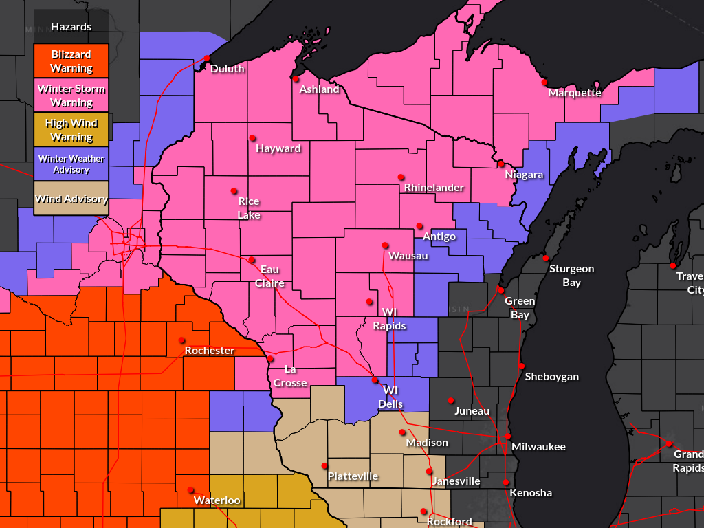
Warnings and advisories issued by the National Weather Service for this event.
 |
 |
 |
 |
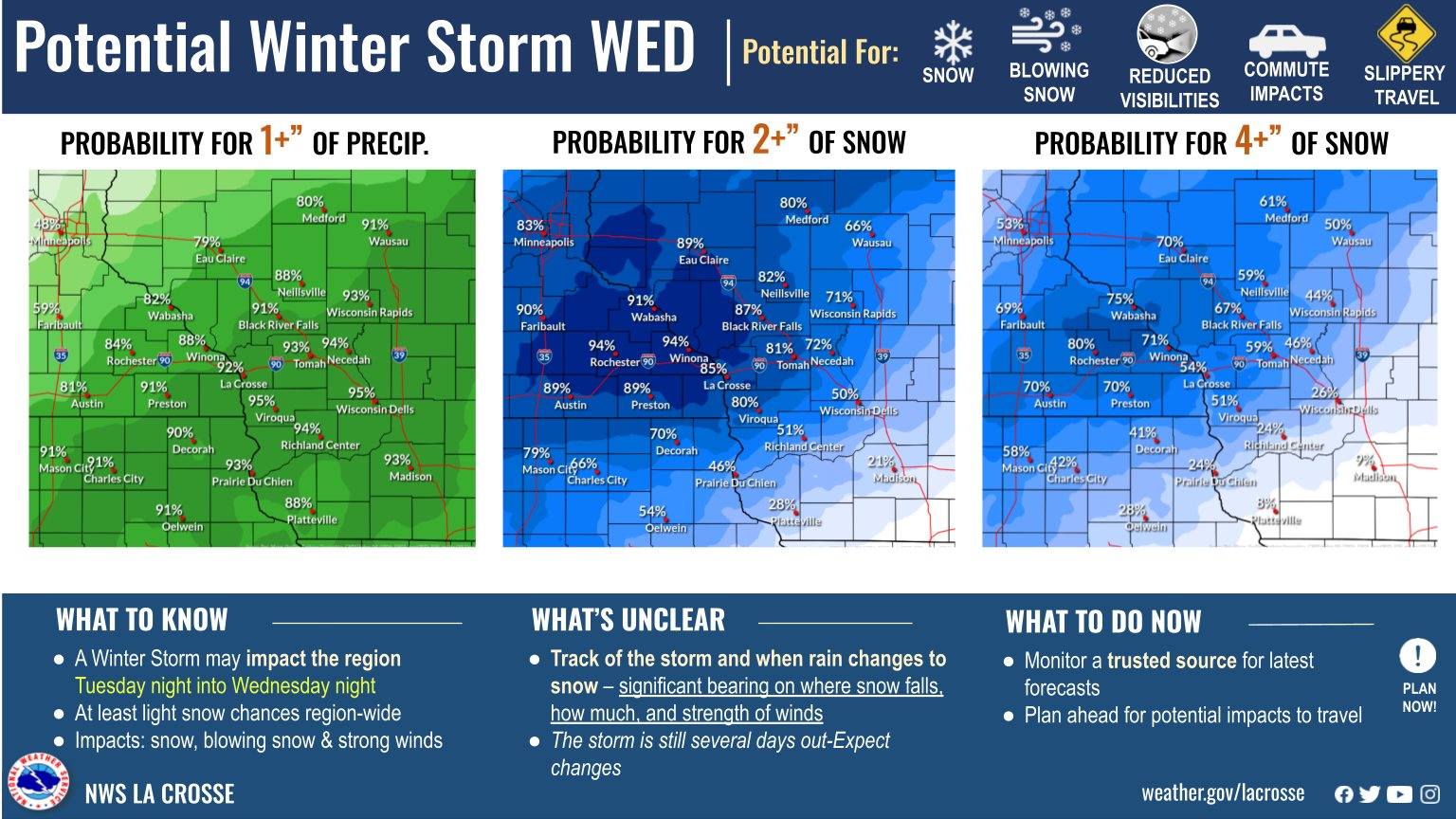
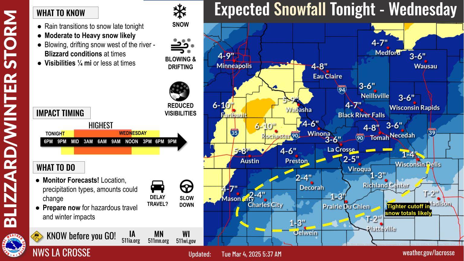
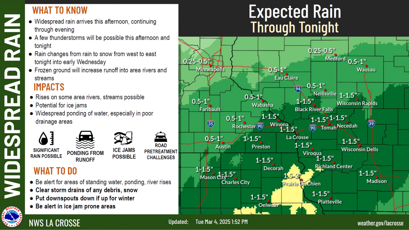
| March 2: Rainfall and snowfall outlook | March 4: Graphic discussing snow and blizzard potential | March 4: Graphic discussing heavy rainfall potential | March 5: Timing graphic for when the rain will transition to snow |
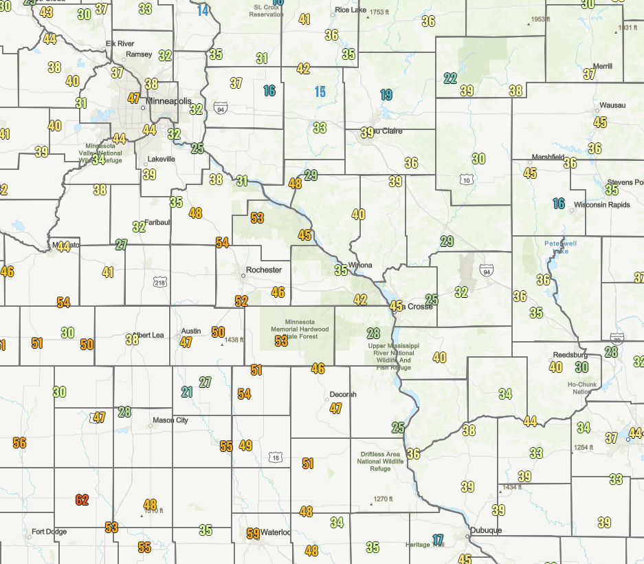
| Snow Forecast Accuracy: To the right is the March 4 2pm issued snow forecast for the storm versus the observed snow amount. The high snow amount axis through Minneapolis turned out to be slightly further west. In Wisconsin, near and north of I-90, slightly warmer temperatures (=more melting), a 2-hour delay in the rain changing to snow, and lighter daytime snow rates all contributed to less snow overall. Much of northeast Iowa and southwest Wisconsin verified the forecast well. |
 |
||
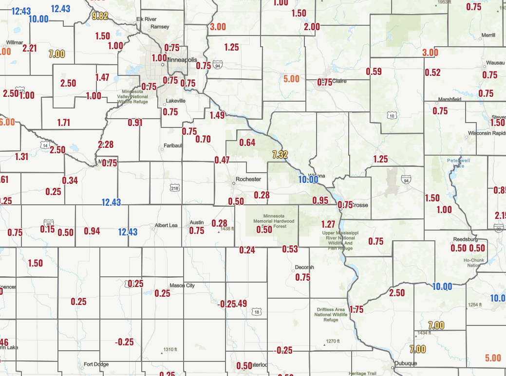
| Wind Gust Forecast Accuracy: To the right is the March 4 2pm issued wind gust forecast with the max observed wind gust in the black circles. Generally wind gusts were overforecast by about 20% (7-10 mph) with the strongest values generally over northeast Iowa. | 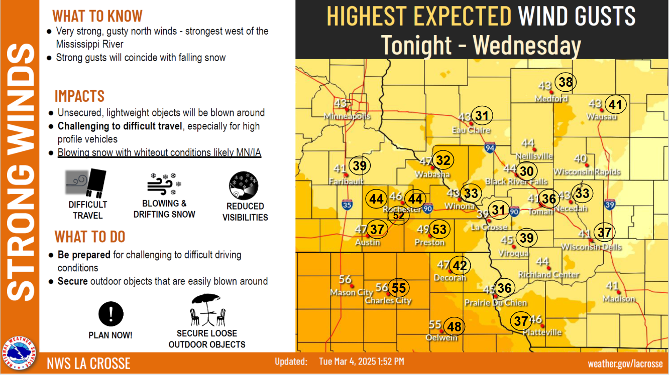 |
||
 |
Media use of NWS Web News Stories is encouraged! Please acknowledge the NWS as the source of any news information accessed from this site. |
|


 Weather Story
 Weather Map
 Local Radar