Upper Mississippi River Climate Summary for March 2025:
Temperatures - Warmer than Normal
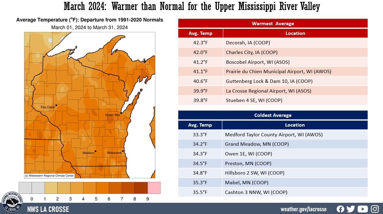
- During March 2025, average temperatures ranged from 33.1°F at Medford Taylor County Airport, WI (AWOS) to 43°F at Decorah, IA (COOP).
- Temperature anomalies ranged from 4°F to 8°F warmer-than-normal.
- There was a 86°F difference between the warmest and coldest temperatures in the Upper Mississippi River Valley.
- The warmest temperature was 86°F at La Crosse Regional Airport (ASOS) on March 28. This was the warmest March temperature at La Crosse, Wi. Meanwhile, the coldest temperature was 0°F at Sparta Fort McCoy, WI airport (ASOS) on March 2.
|
 |
Precipitation - Wetter than Normal
- Precipitation totals varied from 1.23" near Oelwein (COOP) to 4.80" near Melrose, WI (CoCoRaHS).
- Precipitation anomalies ranged from 0.50" to 2.50" wetter than normal.
- The highest one-day precipitation was 1.78" near Gilman, WI (CoCoRaHS) from March 29 to March 30.
|
 |
| Snowfall - Near to Snowier than Normal |
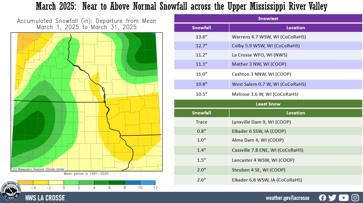
- Snowfall totals varied from a trace at Lynxville Dam 9, WI (COOP) to 13.6" near Warrens, WI (CoCoRaHS).
- Snowfall anomalies ranged from 6" below normal to 8" above normal.
- The highest one-day snowfall was 9.6" near Mather, WI (COOP) from March 19 to March 20.
|
 |
Below are the Febuary 2025 climate summaries for La Crosse, WI, and Rochester, MN.
La Crosse, WI
March 2025 was Warmer and Wetter than Normal in La Crosse, WI
...March 2025 Highlights...
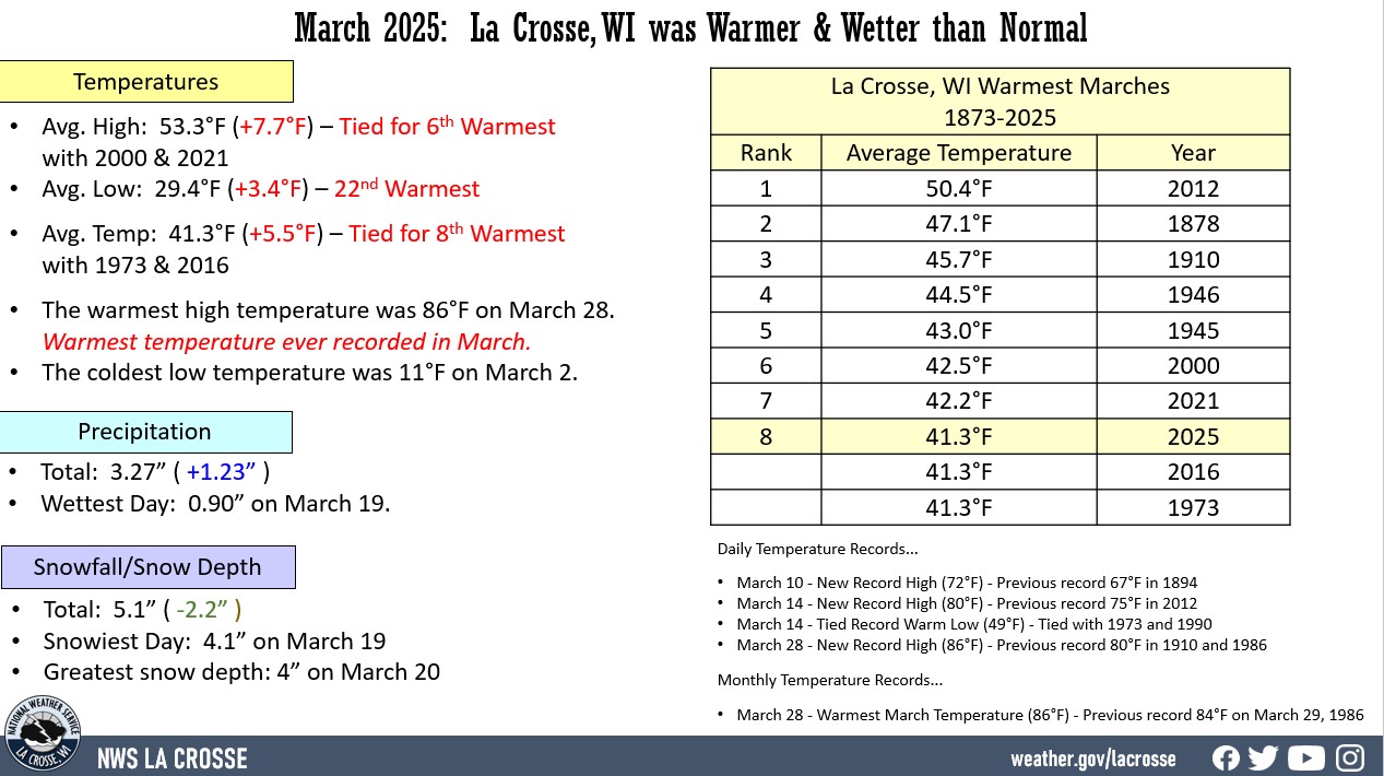
Temperatures - Tied for the 8th Warmest with 1973 and 2016
- During March 2025, the average temperature at La Crosse Regional Airport was 41.3°F.
- This was 5.5°F warmer than the 1991-2020 normal of 35.8°F.
- This was tied for the 8th warmest March with 1973 and 2016.
- This was the warmest March since 2021 (42.2°F - 7th warmest).
- The warmest March average temperature was 50.4°F in 2012.
|
 |
Below are the 20 warmest Marches in La Crosse, WI.
Warmest Marches
in La Crosse, WI
1873-2025
Average
Rank Temperature Year
---- ----------- ----
1 50.4°F 2012
2 47.1°F 1878
3 45.7°F 1910
4 44.5°F 1946
5 43.0°F 1945
6 42.5°F 2000
7 42.2°F 2021
8 41.3°F 2025
41.3°F 2016
41.3°F 1973
11 40.5°F 2010
40.5°F 1968
13 40.4°F 1938
14 40.0°F 2020
15 39.9°F 2024
39.9°F 1977
17 39.2°F 2004
39.2°F 1918
19 39.0°F 1987
39.0°F 1889
- The average high temperature was 53.3°F. This was 7.7°F warmer than the 1991-2020 normal of 45.6°F. This was tied for the 6th warmest with 2000 and 2021. This was the warmest since 2021 (53.3°F). The warmest March average high temperature was 60.2°F in 2012.
- The average low temperature was 29.4°F. This was 3.4°F warmer than the 1991-2020 normal of 26°F. This was the 22nd warmest and the warmest since 2021 (31.2°F - 11th warmest). The warmest average low was 40.5°F in 2012.
- The warmest high temperature was 86°F on March 28.
- The coldest high temperature was 29°F on March 1.
- The warmest low temperature was 49°F on March 14.
- The coldest low temperature was 11°F on March 2.
- The temperature reached or exceeded 80°F on 2 days (March 14 and March 28). This was tied with 2007 and 2012 for the third most in March. Only 1910 and 1986 had more (3 days). Only 8 Marches have had at least 1 or more. On March 14, the temperature reached 80°F. This was the second earliest date in a calendar year. The earliest date in a calendar year was March in 2000. On March 28, the temperature climbed to 86°F. This was the warmest temperature ever recorded in March. The previous record was 84°F on March 29, 1986. It was the earliest 86°F or warmer temperature in a calendar year. The previous record was April 10, 1930 (91°F). This was 13 days earlier than the previous record.
Precipitation - Wetter than Normal
- A total of 3.27" of precipitation fell at La Crosse Regional Airport.
- \This was 1.23" wetter than the 1991-2020 normal of 2.04". This is more precipitation than we have seen during the past 3 months (2.08").
- The wettest day was March 19 when 0.90 inches of precipitation fell.
- Precipitation fell on 13 days. Measurable precipitation fell on 9 days and a trace fell on another 4 days.
Snowfall - Below Normal
- A total of 7" of snow was measured by our official snow observer near La Crosse Regional Airport.
- This was 2.7" below the 1991-2020 normal of 9.7".
- The snowiest day was on February 12 and February 14 when 2.2" of snow fell.
- Snow fell on 12 days (42.9%). Measurable snow fell on 7 days (25%) and trace amounts fell on another 5 days (17.9%).
Snow Depth - Below the Long-Term Average
- A average snow depth measured by the official NWS snow observer near La Crosse Regional Airport was 0.3".
- This was 1.6" below the long-term average of 1.9".
- The greatest snow depth was 4" on March 20.
...Records...
...Looking ahead to April...
- The normal high temperature in La Crosse starts off at 53°F on April 1st and warms to 66°F by the end of the month. The normal low temperature starts off at 33°F on the 1st and warms to 44°F by the end of the month. The warmest April temperature on record is 93°F on April 29, 1910, and April 22, 1980; and the coldest is 7°F on April 1, 1924, and April 6, 1982.
- The normal mean temperature for April is 49°F. La Crosse’s warmest April occurred in 1915 with an average temperature of 56.9°F, and their coldest April occurred in 1874 and 2018 with an average temperature of 39.3°F.
- The normal April precipitation is 3.75". The wettest April occurred in 1973 with 7.31" of precipitation and the driest occurred in 1879 with 0.42". The wettest April day occurred on April 27, 1975, when 3.91" of precipitation fell. Normally, there are 3 days with thunderstorms.
- The normal April snowfall is 2.9". The snowiest April occurred in 2018 with 19" of snow. The snowiest April day occurred on April 9, 1973, when 10.3" of snow fell.
Rochester, MN
March 2025 was Warmer and Wetter than Normal in Rochester, MN
...March 2025 Highlights...
Temperatures - Tied for 7th Warmest with 1977
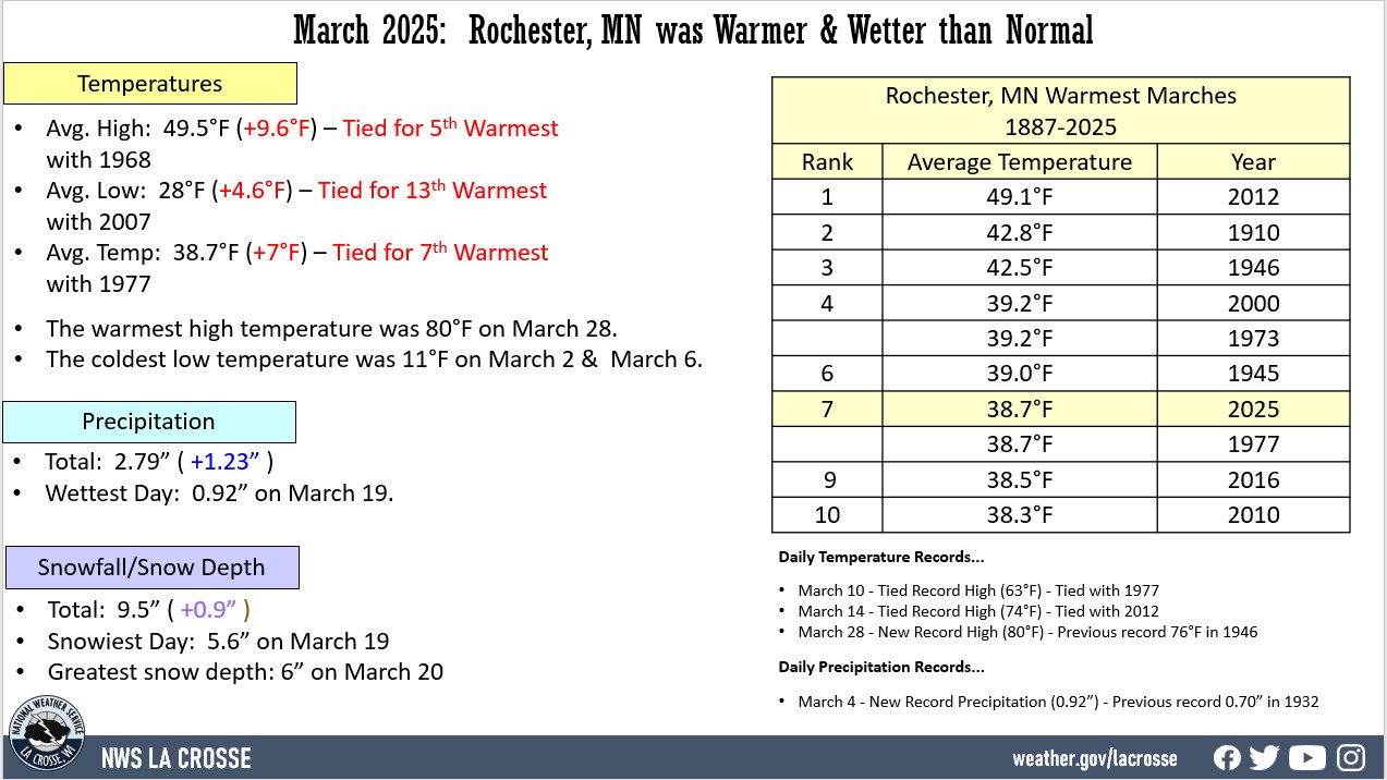
- During March 2025, the average temperature at Rochester International Airport was 38.7°F.
- This was 7°F warmer than the 1991-2020 normal of 31.7°F.
- This was tied with 1977 for the 7th warmest March.
- This was the warmest March since 2012 (49.1°F - warmest).
|
 |
Below are the 10 warmest Marches in Rochester, MN.
Warmest Marches
in Rochester MN
1886-2025
Average
Rank Temperature Year
---- ----------- ----
1 49.1°F 2012
2 42.7°F 1910
3 42.5°F 1946
4 39.2°F 2000
39.2°F 1973
6 39.0°F 1945
7 38.7°F 2025
38.7°F 1977
9 38.5°F 2016
10 38.3°F 2010
- The average high temperature was 49.5°F. This was 9.6°F warmer than the 1991-2020 normal of 39.9°F. This was tied for the 5th warmest with 1968. This was the warmest since 2012 (58.8°F - warmest).
- The average low temperature was 28°F. This was 4.6°F warmer than the 1991-2020 normal of 23.4°F. This was tied for the 13th warmest with 2007, and the warmest since 2021 (28.9°F - 10th warmest). The warmest average low was 39.5°F in 2012.
- The warmest high temperature was 80°F on March 28.
- The coldest high temperature was 26°F on March 1.
- The warmest low temperature was 48°F on March 14.
- The coldest low temperature was 11°F on March 2 and March 6.
- The temperature reached or exceeded 80°F on 1 day (March 28). This was only the 4th March day to reach or exceed 80°F. The other days were March 24, 1910 (82°F), March 17, 2012 (81°F), and March 18, 2012 (80°F).
Precipitation - Wetter than Normal
- A total of 2.79" of precipitation fell at Rochester International Airport.
- This was 0.77" wetter than the 1991-2020 normal of 2.02". This is more precipitation than we have seen during the past 3 months (1.77").
- The wettest day was March 4 when 0.92" of precipitation fell.
- Precipitation fell on 13 days. Measurable precipitation fell on 9 days and a trace fell on another 4 days.
Snowfall - Near Normal
- A total of 9.5" of snow fell was measured by the official NWS snow observer near Rochester International Airport.
- This was 0.9" above the 1991-2020 normal of 8.6".
- The snowiest day was March 19 when 5.6" of snow fell.
- Snow fell on 7 days. Measurable snow fell on 4 days and a trace fell on another 3 days.
Snow Depth - Below the Long-Term Average
- A average snow depth measured by the official NWS snow observer near Rochester International Airport was 0.5".
- This was 2.8" below the long-term average (1893-2025) of 3.3".
- The greatest snow depth was 6" on March 20.
...Records...
Daily Temperature Records...
- March 10 - Tied Record High (63°F) - Tied with 1977
- March 14 - Tied Record High (74°F) - Tied with 2012
- March 28 - New Record High (80°F) - Previous record 76°F in 1946
Daily Precipitation Records...
- March 4 - New Record Precipitation (0.92 inches) - Previous record 0.70 inches in 1932
...Looking ahead to April...
- The normal high temperature in Rochester rises from 48°F on April 1st and warms to 62°F by the end of the month. The normal low temperature rises from 30°F on the 1st and warms to 41°F by the end of the month. The warmest April temperature on record is 92°F on April 24, 2009, and the coldest is 5°F on April 6, 1982.
- The normal mean temperature for April is 45.2°F. Rochester’s warmest April occurred in 1915 with an average temperature of 54.5°F, and its coldest April occurred in 2018 with an average temperature of 34.5°F.
- The normal April precipitation is 3.52". The wettest April occurred in 2001 with 7.30" of precipitation and the driest occurred in 1946 with 0.46". The wettest April day occurred on April 23, 1990, when 3.81" of precipitation fell. Normally, there are 3 days with thunderstorms.
- The normal April snowfall is 3.3". The snowiest April occurred in 2018 with 17" of snow. The snowiest April day occurred on April 20, 1893, when 14" of snow fell.