|
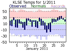
January 2011 started of a tad cool, with below normal temperatures on 7 of the first 9 days. However, the only cold stretch of significance was from the 18th through 23rd. Lows dropped well below zero during this period, with a chilly -19 on the 21st. Unlike December of 2010 when record snowfall fell, January’s total was close to its normal. However, it might have felt like it snowed all month as measurable snow occurred on 15 days, well over the normal of 8. In fact, there were only 6 days when at least a few flurries did not fly. Amounts tended to be small each day though, with at least ½ inch falling 8 of those days, but no more than 3 inches on any one day (the 31st). So, while it snowed a lot, amounts were small, adding up to 11.3 for the month.
|
 |
| |
|
|
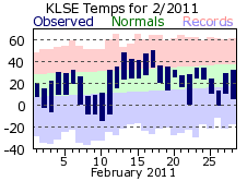
February was below normal for temperatures, but like January, much of the cold came during a short stretch of chilly days. From the 8th through the 11th lows were below zero each day, with highs only in the single digits on the 8th and 9th. Mid-month was rather mild as highs cracked 40 degrees from the 13th through 17th and even reached 50 on the 17th. February got off to a dry start as less than 2 inches of snow fell through the first 19 days. La Crosse managed to avoid a significant snow storm that barreled across Iowa, Illinois and southeast Wisconsin on the 1st and 2nd. A wide band of well over a foot of snow blanketed these areas while only a tenth of an inch fell in La Crosse. The area was not as lucky later on in the month as another storm system took aim on the region. This storm struck the area on the 20th and 21st, bringing a wintry mix of snow, sleet, freezing rain and rain to the region. In La Crosse, temperatures were cold enough for snow to be the dominate precipitation type with 7.7 inches falling over the two-day span. Some sleet did mix in during the evening of the 20th.
|
 |
| |
|
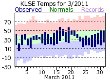
| March continued the cool start to 2011 with average temperatures about 2 degrees below normal. The first two-thirds of the month hovered near normal, but a push of cold air for the last 9 days brought lows in the teens with highs struggling to reach freezing on a couple days. Precipitation was above normal in March, mostly thanks to the 1.82 inches that fell on the 22nd. The first rumbles of thunder for the new year were also heard on this day. There were only 4 days of measurable snowfall with the 5.6 inch monthly total a bit below normal. |
 |
| |
|
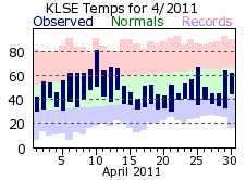
Spring temperatures were hard to come by in April, the 4th consecutive colder than normal month for 2011. Normally a volatile month for temperatures as the jet stream transitions from the winter to summer season, this April only gave a brief glimpse of summer. The 81 degree day on the 10th was the warmest day by far in April; the next warmest was only 67. Highs were in the 40s 9 times and in the 50s 10 times. The cold made snow more likely, and La Crosse recorded 5 days with measurable amounts. The most significant was a late winter storm that brought heavy, wet snows to the region on the 19th. La Crosse received 3.1 inches, but on the ridge tops surrounding the La Crosse, amounts reached 8 inches. Over a week before that storm, however, severe thunderstorms rained hail as large as 3 inches on La Crosse. Southern parts of the city were impacted by the largest hail, resulting in extensive roof, home and car damage.
It was a long winter for La Crosse with a record 32.3 inches of snow falling in December and snowfall then continuing to fall into the middle of April. The total for the 2010-11 season was 64.7 inches, well above the 43.6 normal and 9th snowiest winter all-time for La Crosse.
|
 |
| |
|
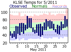
May continued the cool spring trend, averaging almost 2 ½ degrees below normal. It was a very volatile month though for temperatures as highs peaked in the 80s 6 times, but only climbed into the 40s and 50s an equal number of times. The last freeze of the spring was on 4 th, almost a week later than normal. Precipitation was close to normal for a typical May, but nearly 90% of the total was accounted for by 3 days: the 9 th, 22 nd, and 25 th. Over three-quarters of an inch fell each of those days, with a high of 1.20” on the 22 nd. Of particular note for La Crosse was the touchdown of a tornado on May 22nd. This EF2 tornado was the first tornado to strike La Crosse since the 1960s and damaged many businesses, homes and trees on the south side of town.
|
 |
| |
|
|
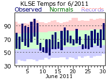
June brought the warmest and wettest day of 2011 to La Crosse. Temperatures blistered to 100 degrees on the 7th, the first time La Crosse broke the century mark since 2006. Despite the very hot day, June temperatures averaged near normal. This was thanks to some swings that are more typical of spring rather than summer. After the hot 7th it quickly cooled to 64 on the 9th, and then a record cool 57 for a high on 10th. In all, there were 5 days where highs reached or exceeded 90 degrees, but 7 days where it did not top 70. For precipitation, torrential rain led to a total of 4.50 inches on the 18th. It was the 5th wettest day on record for La Crosse. The 18th was the start of 7 consecutive days with measurable rainfall, with a total of 7.12 inches during this period. Overall, 8.63 inches fell in June making it the 8th wettest on record.
|
 |
| |
|
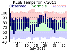
Summer would baste the region in heat during the month of July. Temperatures topped 90 degrees 8 times, just missing 100 a couple days. The average temperature of 77.6 degrees was the 8th warmest on record. Heat advisories and warnings were in effect at various times to account for the dangerous heat. There was a brief 4 day break from the month long heat wave with a string of highs in the 70s from the 12th through 15th. Rainfall was close to the monthly normal, but came in big chunks. Over ½ inch fell on 5 days, with two of those recording over an inch.
|
 |
| |
|
|
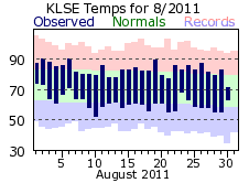
August was fairly close to its monthly normal with respect to temperatures with no significant hot or cold periods. Precipitation, however, was down compared to the previous summer months and a typical August. While there was 8 days with measurable precipitation, less than ¼ inch fell most of the days, with the 1.02 inch monthly high on the 13th almost 60% of the monthly total.
On the whole, the summer of 2011 was a warm and wet one. The average temperature of 73.0 degrees was the 20th warmest on record for La Crosse, while the 15.03 inch rainfall was over 2 inches above normal.
|
 |
| |
|
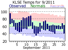
September kicked off the transition to fall with a sultry 95 degree day on the first. This would be the exception though as highs only reached 80 degrees or better 6 more times. After a high of 88 on the 12th, temperatures would be below normal on 15 of the remaining 18 days. Temperatures wouldn’t crack 60 degrees on the 15th or 16th. Precipitation was about ½ inch below the September normal with a stretch of dry days from the 5th through 16th accounting for most of this deficit. Out of the 9 days there was measurable rainfall, 6 of those recorded two-tenths of an inch or greater.
|
 |
| |
|
|
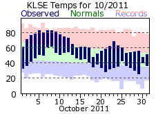
Like 2010, the first half of October 2011 was very mild. Temperatures were above normal from the 3rd through the 17th with highs reaching 80 or greater from the 5th through 9th. The second half would be cooler though with the first dip into freezing temperatures of the approaching winter season on the 29th. This was about two weeks later than normal. October would continue the dry trend, finishing around ½ inch below normal. There was a trace or less of rainfall on 26 of the 31 days, with 1.61 inches of the 1.63 total coming on 3 days. Normally, the end of October brings the first flakes of snow for the new winter season. Not this October though, as nary a flurry flew.
|
 |
| |
|
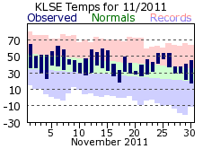
| November saw a continuation of the relatively mild temperatures, rounding out 4 degrees above its normal. The warmest period was at the end of the month with the last 9 days averaging 8 ½ degrees above normal. In fact, low temperatures on the 24th, 25th, and 26th were at or above the normal highs for late November. The dry fall conditions also persisted with measurable rainfall on only 5 days and ½ of the monthly total falling on one day (the 9th). It did snow though, with 0.7 inches falling on the 9th. However, that would be the only measurable snow for the month, well under the 4.1 inch normal. |
 |
| |
|
|
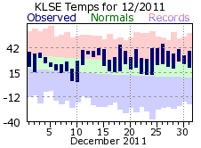
December started out on the cool-side, with below normal temperatures on 7 out of the first 10 days. However, mild air would move in after that and hold across the area for the rest of the month. Highs reached or exceeded 40 degrees 9 times, while low temperatures for the last week of December were closer to the average highs rather than lows. Snow was hard to come by for what is usually the snowiest month of the year for La Crosse. Measurable snow fell on 8 days, but only ½ inch or less was recorded on 6 of those. A storm system toward the end of month brought a mixed bag of snow, rain, freezing rain and sleet to La Crosse on the 30th.
|
 |
| |
|
|
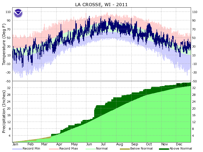
2011 will be remembered as a tale of two halves: one exceeding wet and cool, the other very dry and mild. While La Crosse finished around 2 inches above normal for precipitation, 75% of the total came in the first 7 months. After that, less than 9 inches fell which was over 4 ½ inches below normal. The wet first half of the year helped keep it cool as the first 6 months all averaged below normal temperatures. The last half would experience a flip with mild conditions 5 out of the last 6.
|
 |