| Temperatures | Precipitation | ||||||
| Month | High | Low | Average | Departure | Total | Departure | Snow |
| January | 23.2 | 6.0 | 14.6 | -1.3 | 1.30 | +0.11 | 18.3 |
| February | 24.6 | 5.3 | 14.9 | -7.7 | 1.14 | +0.15 | 15.0 |
| March | 38.4 | 19.4 | 28.9 | -5.7 | 2.15 | +0.15 | 7.9 |
| April | 55.9 | 36.8 | 46.3 | -2.1 | 6.74 | +3.36 | 0.8 |
| May | 68.3 | 44.7 | 56.5 | -4.1 | 3.52 | +0.14 | 0.0 |
| June | 78.3 | 58.5 | 68.4 | -1.2 | 7.00 | +3.00 | ... |
| July | 84.0 | 62.9 | 73.5 | -0.5 | 6.84 | +2.59 | ... |
| August | 82.2 | 58.6 | 70.4 | -1.2 | 0.69 | -3.59 | ... |
| September | 75.0 | 54.1 | 64.6 | +1.9 | 2.08 | -1.32 | ... |
| October | 61.4 | 40.4 | 50.9 | +0.3 | 1.16 | -1.00 | T |
| November | 43.4 | 28.8 | 36.1 | +0.6 | 1.70 | -0.40 | 4.0 |
| December | 24.7 | 3.5 | 14.1 | -7.7 | 2.32 | +1.09 | 32.7 |
| TOTALS: | 55.0 | 34.9 | 44.9 | -2.6 | 36.64 | +4.28 | *** |
Records
Temperature...
Highs:
Lows:
Highest Lows:
Lowest Highs:
Monthly:
Seasonal:
Yearly:
Precipitation...
One-day pcpn:
One-day snowfall:
Monthly pcpn:
Monthly snowfall:
Seasonal precipitation:
Yearly precipitation:
|
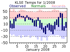
After below zero lows for the first 3 days of January, mild air returned through mid month, with lows close to the average highs for this time of year. The warm up wouldn’t last though, as cold Canadian air flowed back into the region, holding fast through the rest of the month. Below zero lows were recorded on 12 of the last 15 days, with temperatures never climbing above zero on the 19th. Unlike January of 2007 when there were only 3 days with below zero readings, this January dropped below zero on 15 days. The average is 12. This cold start to the year would be a harbinger of things to come. Snowfall was above average for the month, with the bulk of the snow coming via two events: 5 inches on the 16th and 17th, and 8.5 inches on the 21st and 22nd. |
 |
| Like January, February started off mild, but temperatures would quickly tumble after the first week. After the 5th, below normal temperatures were recorded on 21 of the remaining 24 days (including leap day). February also brought a day where temperatures could not crack zero, with a high of only -2 on the 10th. Snowfall for the month was about double of the monthly average, and fell fairly uniform throughout the month. There were 4 days of 2 inches or more, with the largest one-day amount of 5 inches on the 14th. | 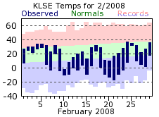 |
| March started off quite cold, moderated a bit by mid month, with more cold air for the end of the month. The average temperature was almost 6 degrees below normal, and continued the trend of cold overall conditions for the start of 2008. Precipitation was right around the monthly normal, but this is deceptive as nearly 90% of the monthly total came on two days. The 21st brought about ½ inch of liquid precipitation, which came in the form of 6.8 inches of snow (a record for the day). Then, to end the month, La Crosse’s first thunderstorm of the year dropped 1.25 inches of rain. | 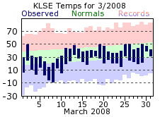 |
| April was a soggy month, with measurable rain falling on 14 days, and 3 days recording over an inch (record rainfalls were set on the 10th with 1.20 inches and the 18th with 1.58 inches). A late season snowfall even brought ½ inch of snow to La Crosse on the 28th, which was also the last snowfall of the 2007-08 season. All that helped keep April cool, finishing around 2 degrees below its average. The last occurrence of freezing temperatures for the late winter and early spring came on the 29th. Wind speeds for the month averaged close to 10 mph, making April the windiest month of 2008. There were 4 days with average speeds of 15 mph, and a couple days where averages flirted with 20 mph. However, the windiest day of the year would come several months later. | 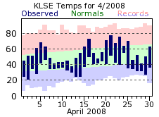 |
| Rainfall for May was right around the monthly normal and fairly spread out. Like April, there were 14 days with measurable rainfall, with 5 of those recording a ¼ inch or greater. There was one larger event on the 29th, with a storm system dropping 1.45 inches of rain that day. The cool trend continued for another month, with May finishing 4 degrees below its normal. Despite this, May still managed to reach 80 degrees 3 times | 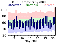 |
| June got the summer months off to a very wet start, with over 6 inches of the monthly total falling in the first 12 days. The 7th and 8th were particularly soggy, with 4.40 inches drenching these two days. The 2.91 inches on the 8th was not only the wettest day of 2008, but also set a record for the 8th. Drier conditions would settle in for the rest of the month, with only 4 more days of measurable precipitation after the 12th, and the bulk of that fell on the 27th (0.66 inches). Temperatures were cool to seasonable, with no appreciable warm up the entire month. The high for the month only topped out at 89 degrees. In an average June, 4 days of 90 degrees or greater can be expected. | 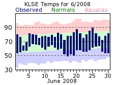 |
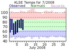
| July brought more rain to the area, with nearly another 7 inches falling through the month. The rain would come in buckets, with 5 days recording a ½ inch or greater, and 3 of those over an inch. The bulk of the rain would come in a 2 week period, with 6.67 inches of the 6.84 total falling from the 7th through the 19th. The end of the month was rather dry, with less than a 1/10 of an inch falling after the 19th. Temperatures stayed seasonable to cool, with no significant warm ups. Highs did reach 90 twice, falling well short of the monthly average of 7 such occurrences.
The 13.84 inches of rain that fell in June and July was the 8th wettest start to a summer on record. The wettest came in 1978 when 16.19 inches fell. |
 |
| August continued the dry trend from the later part of July, finishing 3 ½ inches below its normal. Temperatures continued to stay cool to seasonable, with again no significant warm periods. Highs only warmed to 90 once, which like the other summer months, was below normal. In fact, the total of three 90 degree or greater days for June, July and August was well below the summer normal of 15. August also marked the 8th consecutive month with below normal temperatures for La Crosse. | 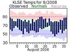 |
| Dry weather continued for September, with only around 1/3 of an inch of rain falling through the first 22 days. Over 75% of the monthly total of 2.08 inches would fall after that, with half of that occurring on the 24th (1.11 inches). For the first time of 2008 though, a month would finish above normal for temperatures. The warmest day of the year occurred on the second, with a 93 degree day. A relatively mild period then took hold for the later part of the month, with highs hovering around 80 degrees from the 16th through the 27th. All in all, September got the traditional fall months off to a mild and dry start. | 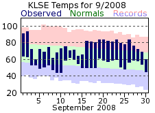 |
| The dry conditions persisted in October, but unlike September, what did fall was spaced fairly evenly through the month. Out of the 7 days where measurable rain fell, a tenth of an inch or more was recorded on 5 of them. The average temperature was right around the seasonable normal, but there was quite a bit of variance from day to day as the summer warmth transitioned toward the cold of the winter. The last 80 degree day of the year came on the 12th, while highs only reached 43 on the 27th. The first freeze of the cold season came on the 21st for La Crosse, about a week and a half later than usual. The windiest day of the year was also found in October, with average speeds on the 26th of 20.6 mph. | 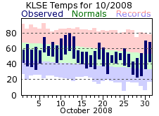 |
| Temperatures more fitting of mid September greeted the first week of November as highs approached, or exceeded, 70 degrees. The warmth would not last long, as seasonably cool air returned by the 7th, sticking around through month’s end. Still, the very warm start helped the month finish slightly above normal. The first measurable snowfall of the new winter season fell on the 16th, which is just a few days off the average date of the 11th. The first, more significant snow of the season came at the end of the month, with 3.7 inches falling on the 30th. Overall though, precipitation was below normal for November, making it the 4th consecutive month with relatively dry conditions. | 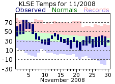 |
| Snowy would be the easiest way to describe December, as at least a trace or more fell on 23 out of the 31 days. Measurable snow fell on 15 days, with 11 of those recording an inch or more. This is well above the normal of 3 such days. The biggest snow event of the month came on the 19th and 20th, with 10.2 inches falling over these two days. The grand total of 32.7 inches made it the snowiest December on record, and the 4th snowiest out of all months. If not for the appreciable snowfall, cold would be the defining word for December 2008. Aside from two brief warm-ups, a steady supply of arctic air kept temperatures below normal. One of those short warm-ups was more notable for the dramatic change in temperature rather than with a high above 40 degrees. On the 14th, highs reached 44 in La Crosse, but as an arctic cold front swept through late that afternoon, temperatures dropped 20 degrees in two hours! By the morning of the 15th, lows had bottomed out at -5, resulting in a 49 degree diurnal change between the high and low temperature. | 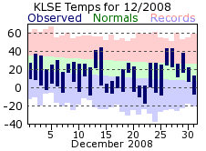 |
| Overall, 2008 will be remember for its wet and cold beginning, with only a mild fall bringing a break from below normal temperatures. This was the coldest year since 1979 and above normal temperatures were experienced only about 1/3 of the time. Considerable snowfall in the early part of the year would return for the end, with record setting snows falling in December. Heavy rains fell during the spring and early summer months, with two-thirds of the yearly total falling from April through July. | 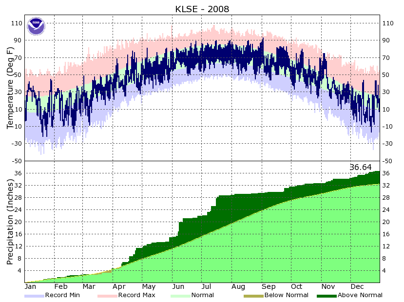 |
| Highest temperature for 2008 | 93 on September 2nd |
| Lowest temperature for 2008 | -22 on January 20th and 24th |
| Highest one-day precipitation | 2.91" on June 8th |
| Highest one-day snowfall | 8.0" on January 21st |
| Number of days with highs at or above 90 degrees | 5 |
| Number of days with highs at or below 32 degrees | 86 |
| Number of days with zero or below temperatures | 43 |
| Peak wind gust | 58 mph from the west on July 10th |
| Number of days with measurable precipitation | 129 |
| Percentage of days with measurable precipitation | 35% |
| Number of days with above normal temperatures | 137 |
| Percentage of days with above normal temperatures | 37% |

