Overview
|
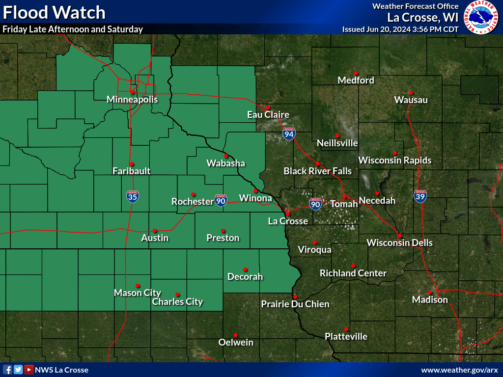
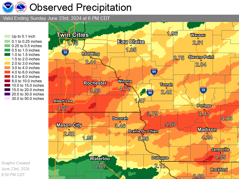
After a very wet 30-day period, several days of repeat thunderstorms produced copious amounts of additional rainfall which led to flash flooding and rises on many area rivers. Some areas easily saw 7 to 10 inches of rain fall between June 20-22. The flooding rain led to closures of Interstate 90 near Austin, MN and other various highways around the region. Mud and rock slides also occurred in some of the hilly driftless areas. Some river locations rose into moderate to major levels causing evacuations of low lands, some sand bagging, and extended road closures. Other severe weather occurred during the afternoon and evening of June 22nd when thunderstorms produced at least one tornado in far southwest Wisconsin and possibly some other sporadic wind damage. |
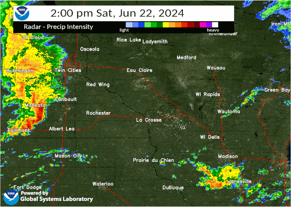
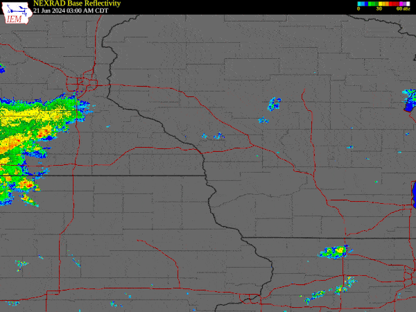 Radar loop from 3 am Friday June 21 through 9 pm Saturday June 22 2024 |
Tornadoes:
|
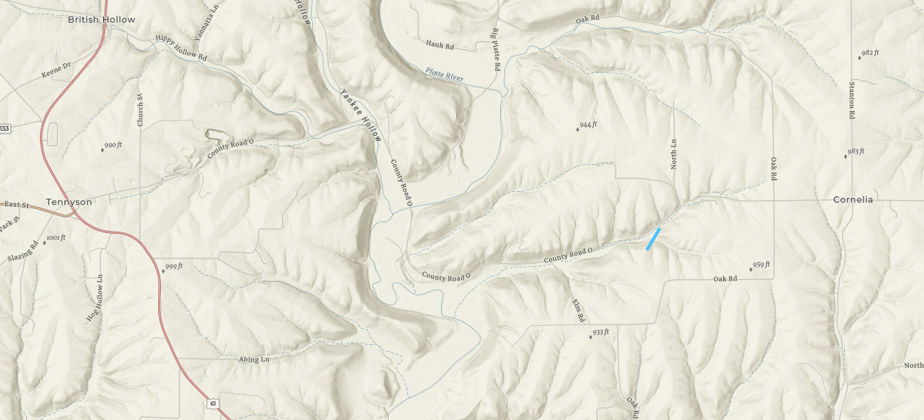
Tornado - Cornelia, WI
|
||||||||||||||||
|
||||||||||||||||
The Enhanced Fujita (EF) Scale classifies tornadoes into the following categories:
| EF0 Weak 65-85 mph |
EF1 Moderate 86-110 mph |
EF2 Significant 111-135 mph |
EF3 Severe 136-165 mph |
EF4 Extreme 166-200 mph |
EF5 Catastrophic 200+ mph |
 |
|||||
Flooding - Hydrographs
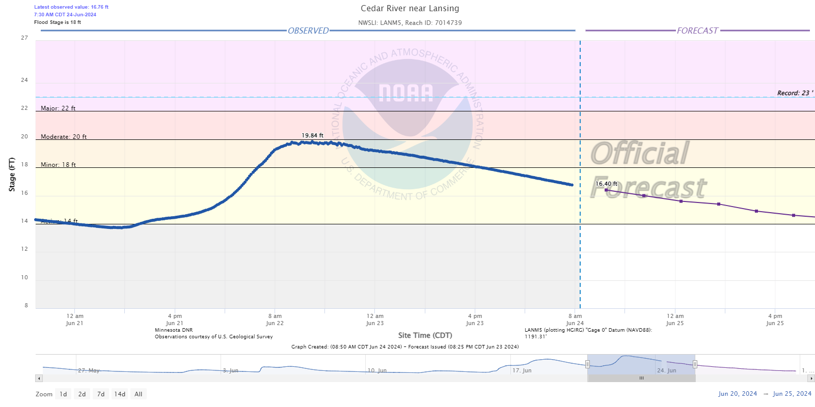
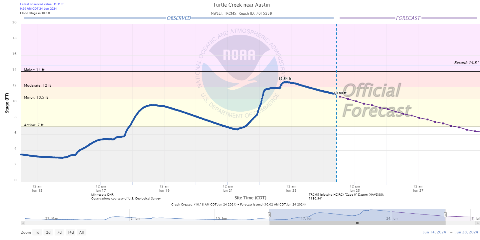
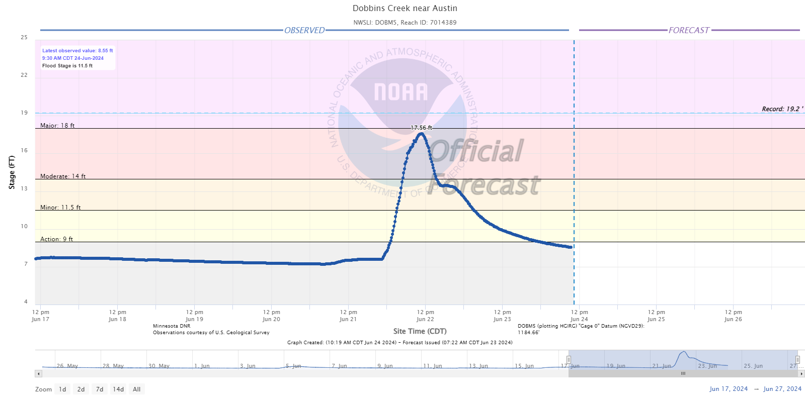
Cedar River Basin
 |
 |
 |
| Cedar River near Lansing, MN |
Turtle Creek near Austin, MN |
Dobbins Creek near Austin, MN |
 |
 |
 |
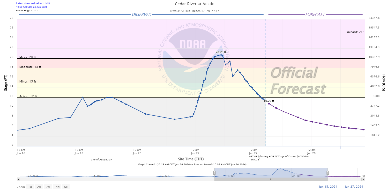
| Cedar River at Austin, MN |
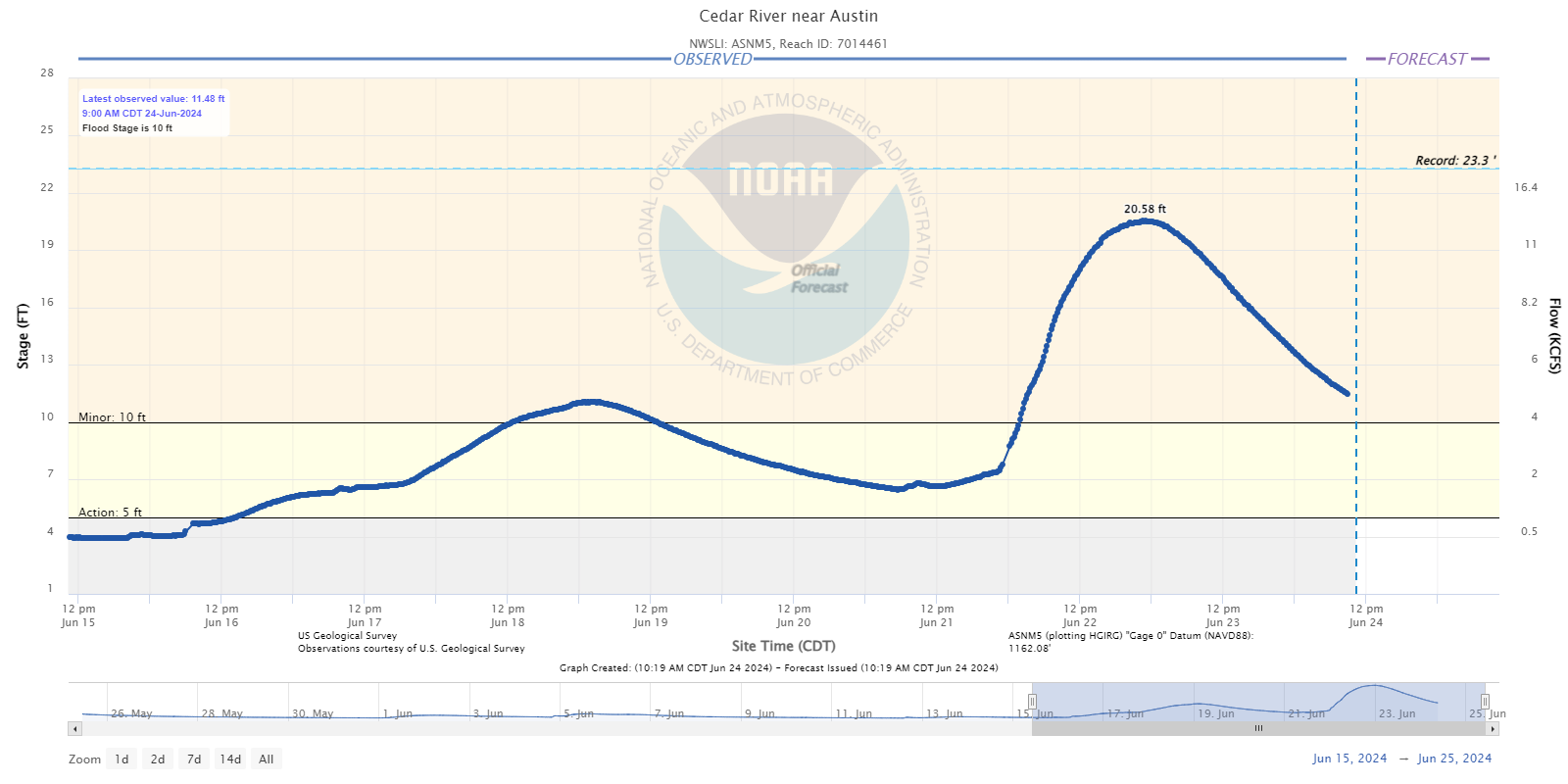
Cedar River near Austin, MN |
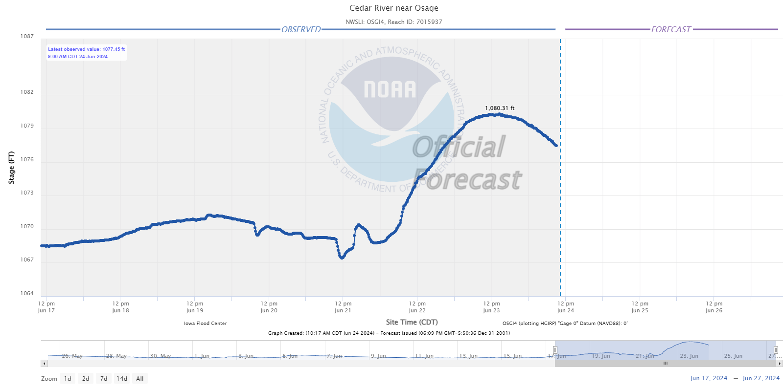
Cedar River near Osage, IA |
 |
 |
 |
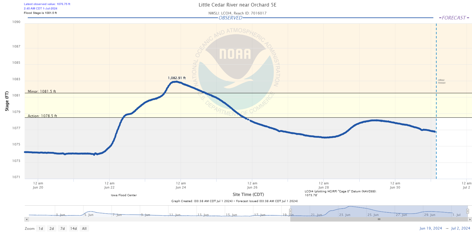
| Little Cedar River near Orchard, IA |
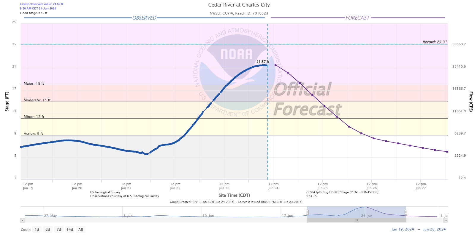
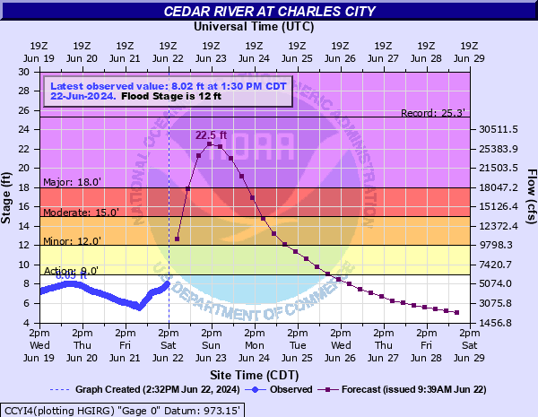
Cedar River at Charles City, IA |
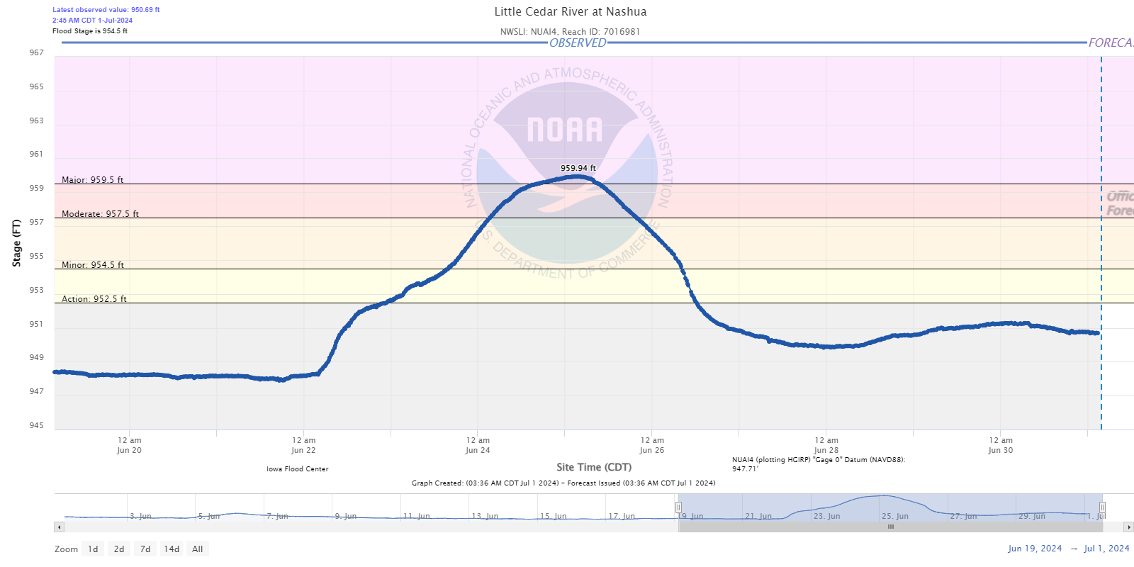
Little Cedar River at Nashua, IA |
Upper Iowa River Basin
 |
 |
 |
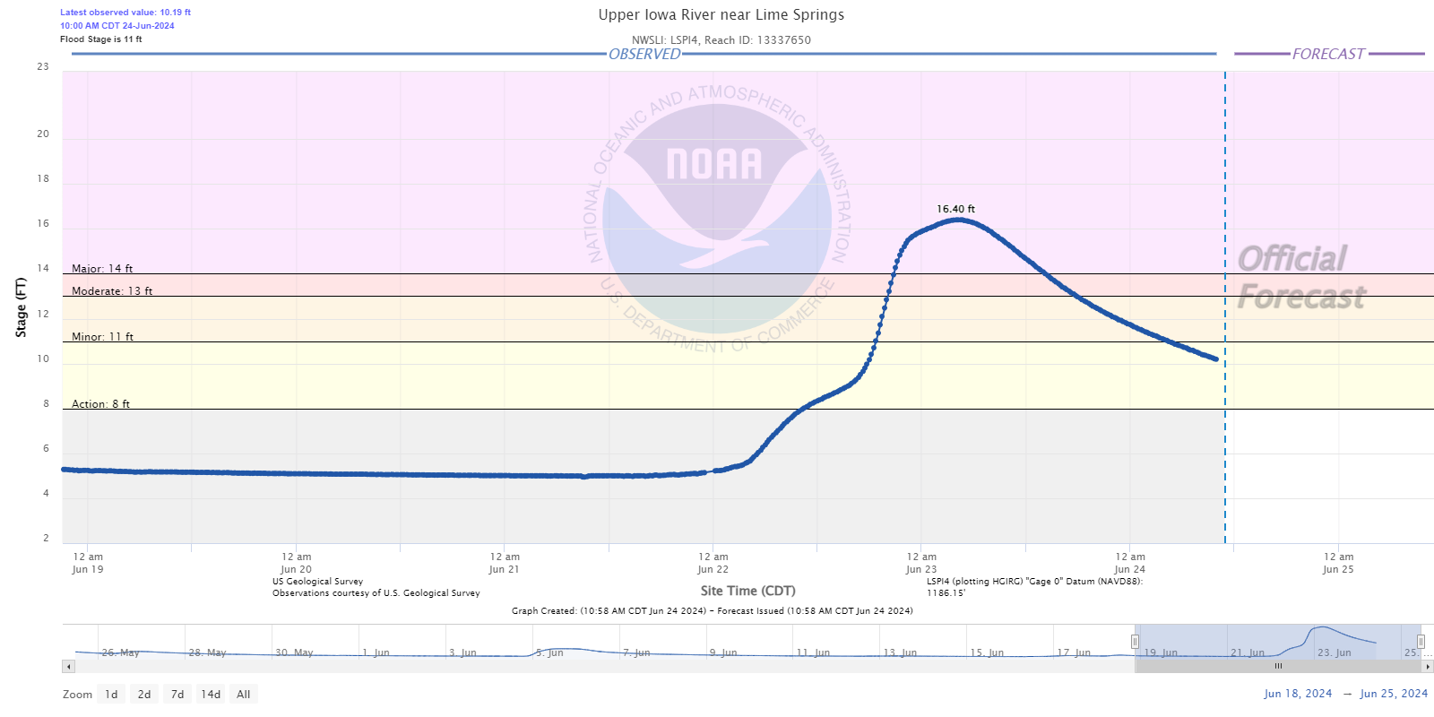
| Upper Iowa River near Lime Springs, IA |
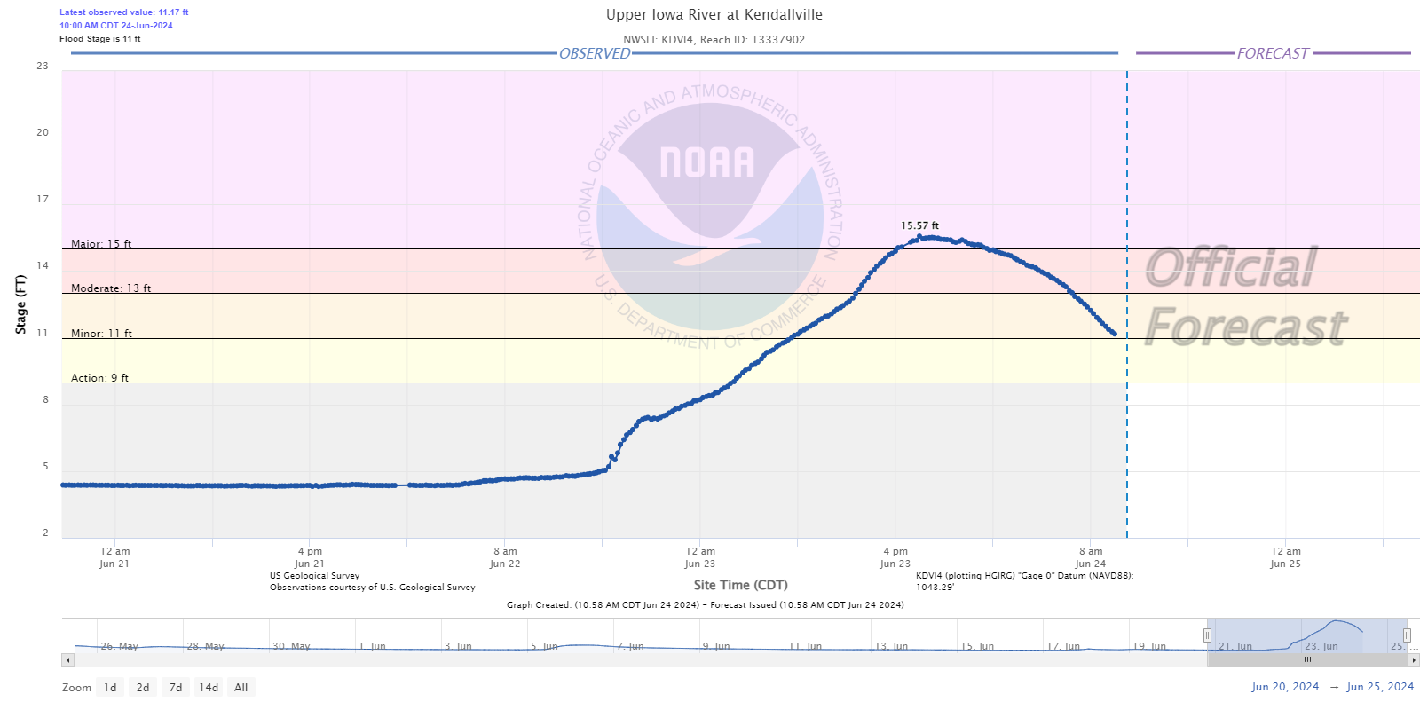
Upper Iowa River at Kendallville, IA |
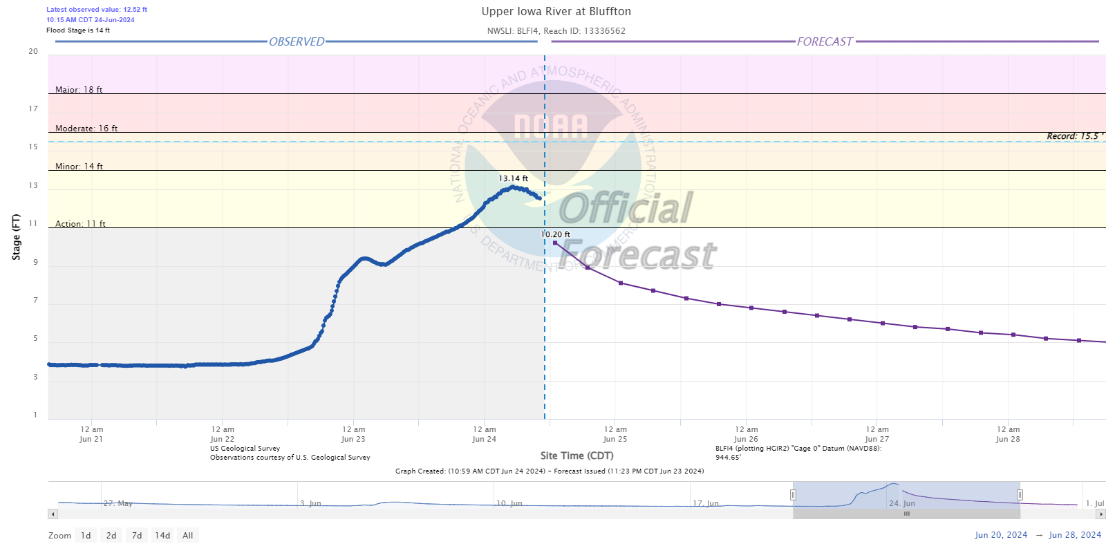
Upper Iowa River at Bluffton, IA |
 |
 |
 |
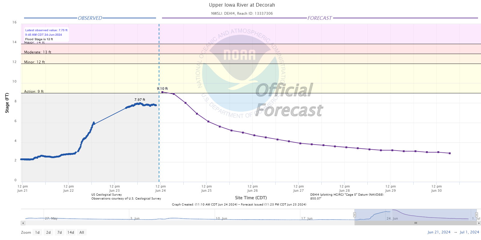
| Upper Iowa River at Decorah, IA |
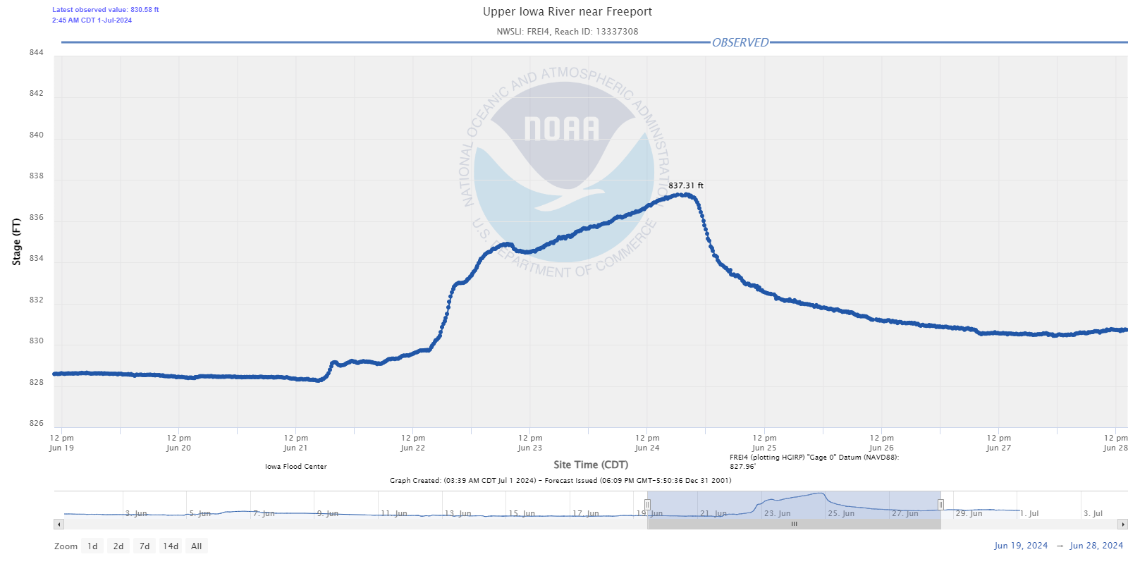
Upper Iowa River near Freeport, IA |
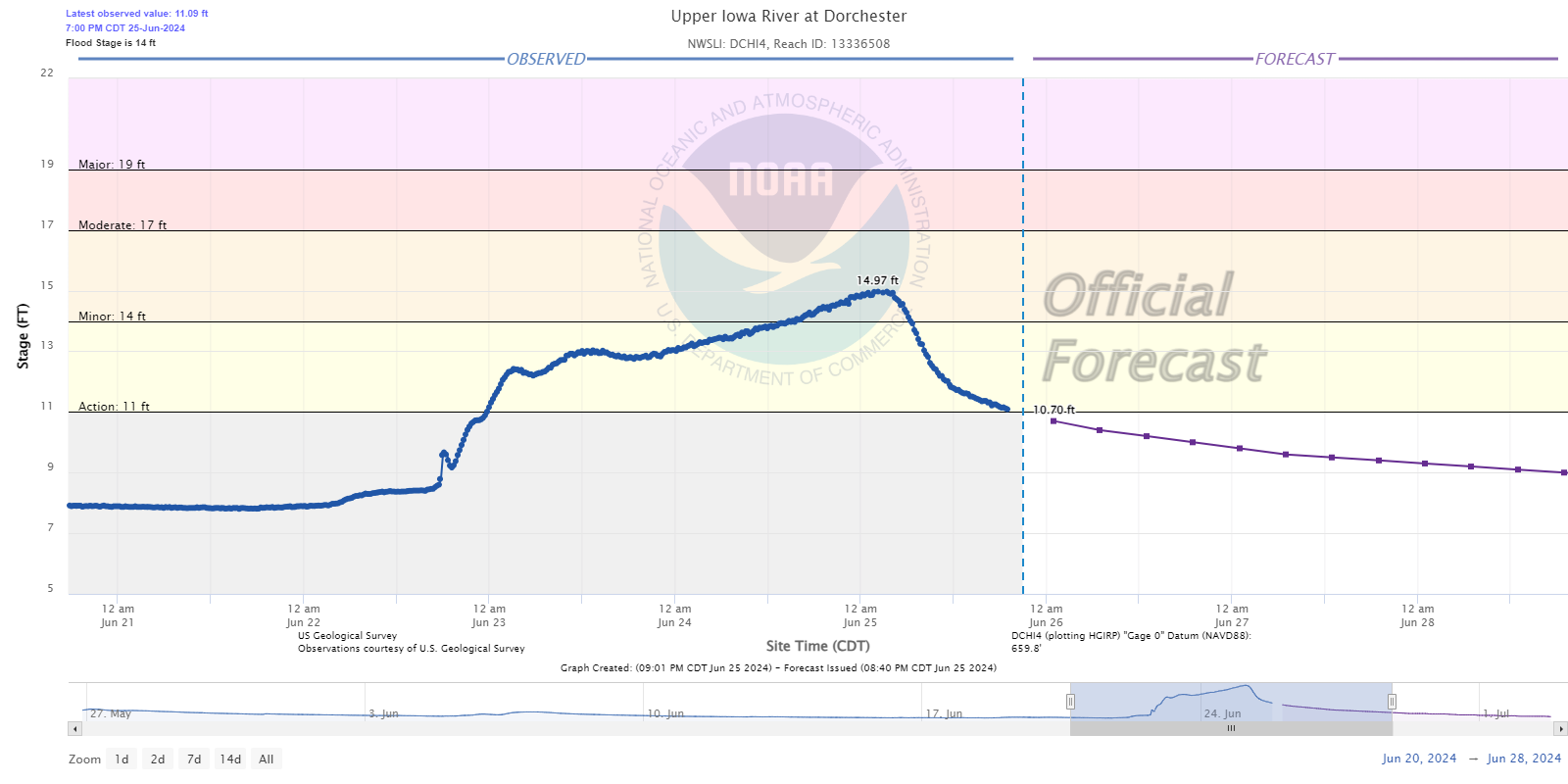
Upper Iowa River at Dorchester, IA |
Root River Basin
 near Pilot Mound.png) |
 near Rushford 2W.png) |
 at Houston.png) |
| Root River near Pilot Mound, MN |
Root River near Rushford, MN |
Root River at Houston, MN |
Zumbro River Basin
 |
 |
 |
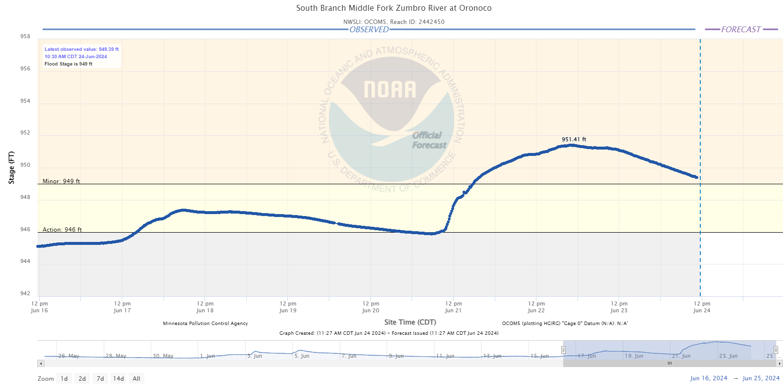
| South Branch Middle Fork Zumbro River at Oronoco, MN |
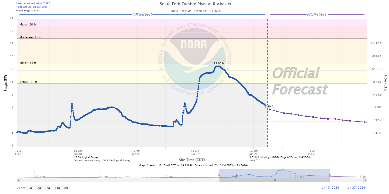
South Fork Zumbro River at Rochester, MN |
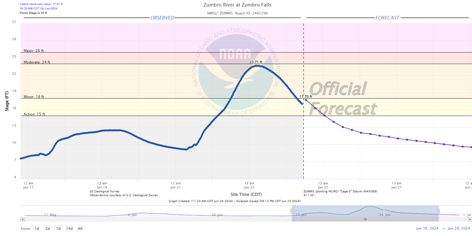
Zumbro River at Zumbro Falls, MN |
Mississippi River Basin
 |
 |
 |
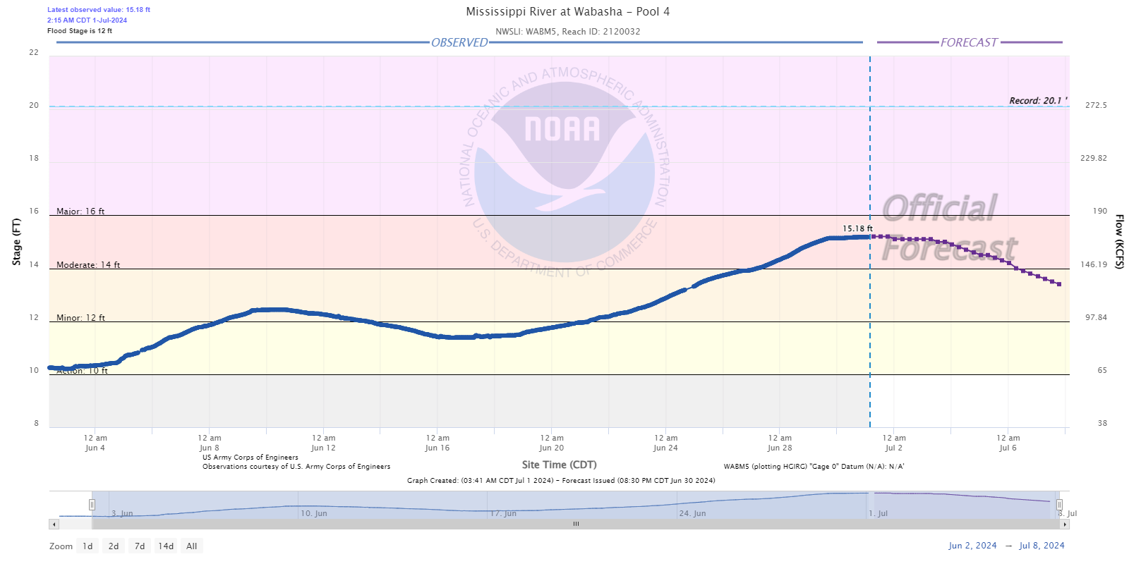
| Mississippi River at Wabasha, MN |
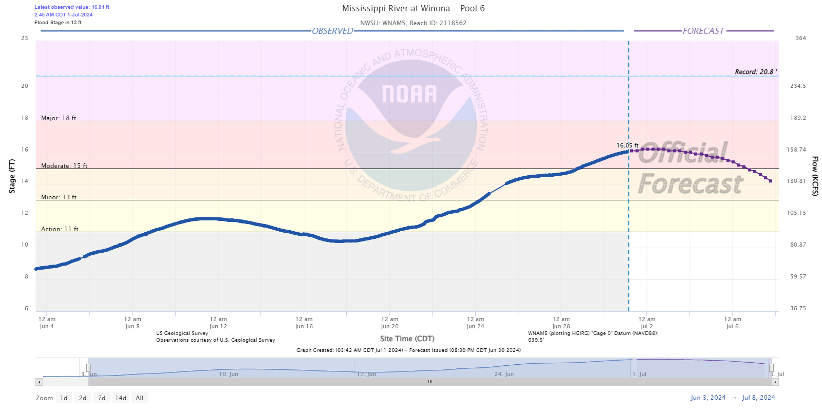
Mississippi River at Winona, MN |
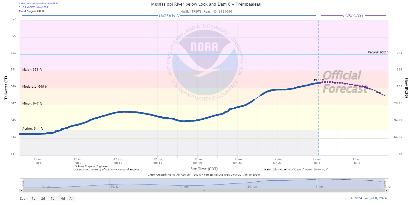
Mississippi River at Trempealeau, WI |
 |
 |
 |
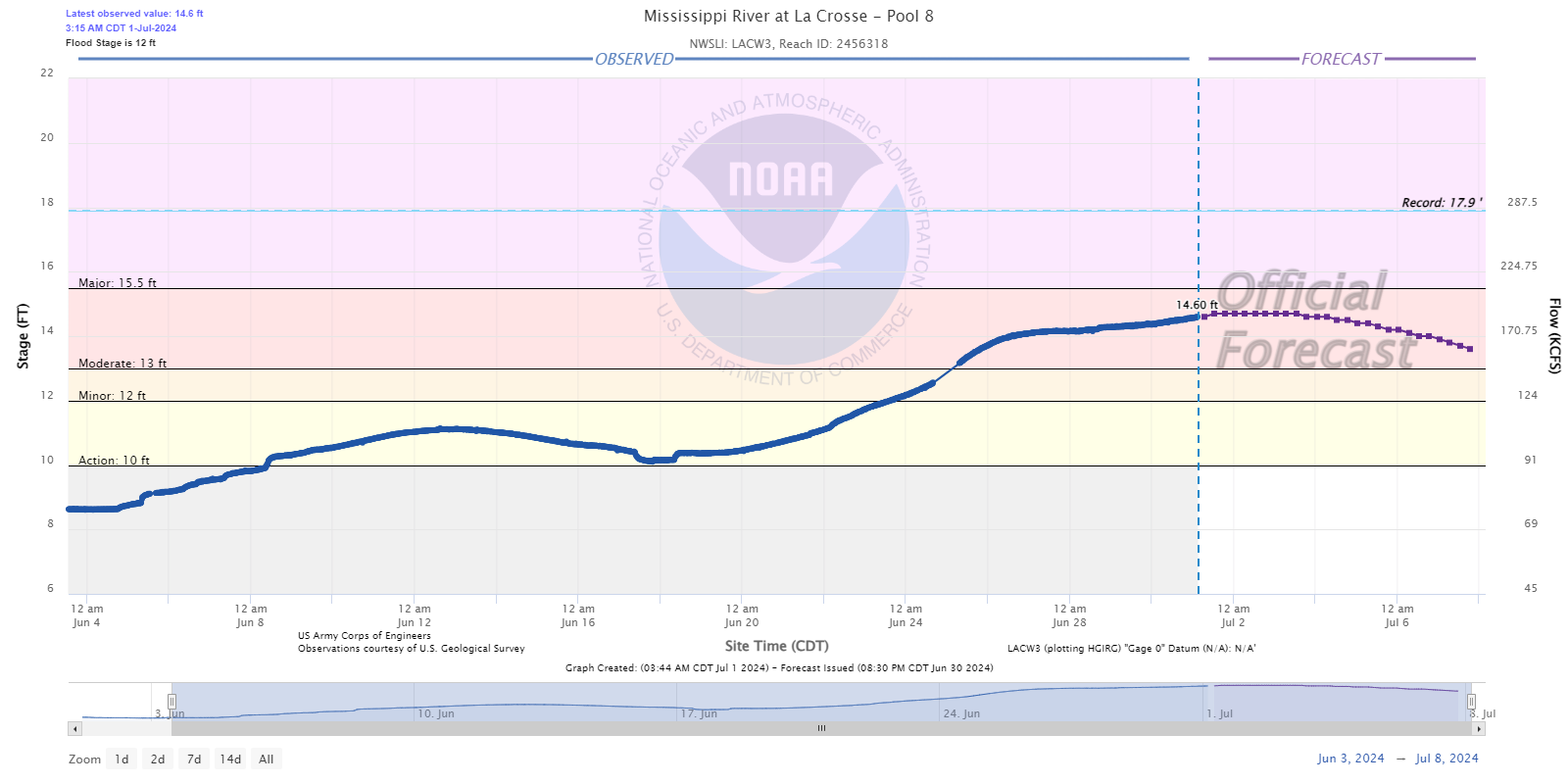
| Mississippi River at La Crosse, WI |
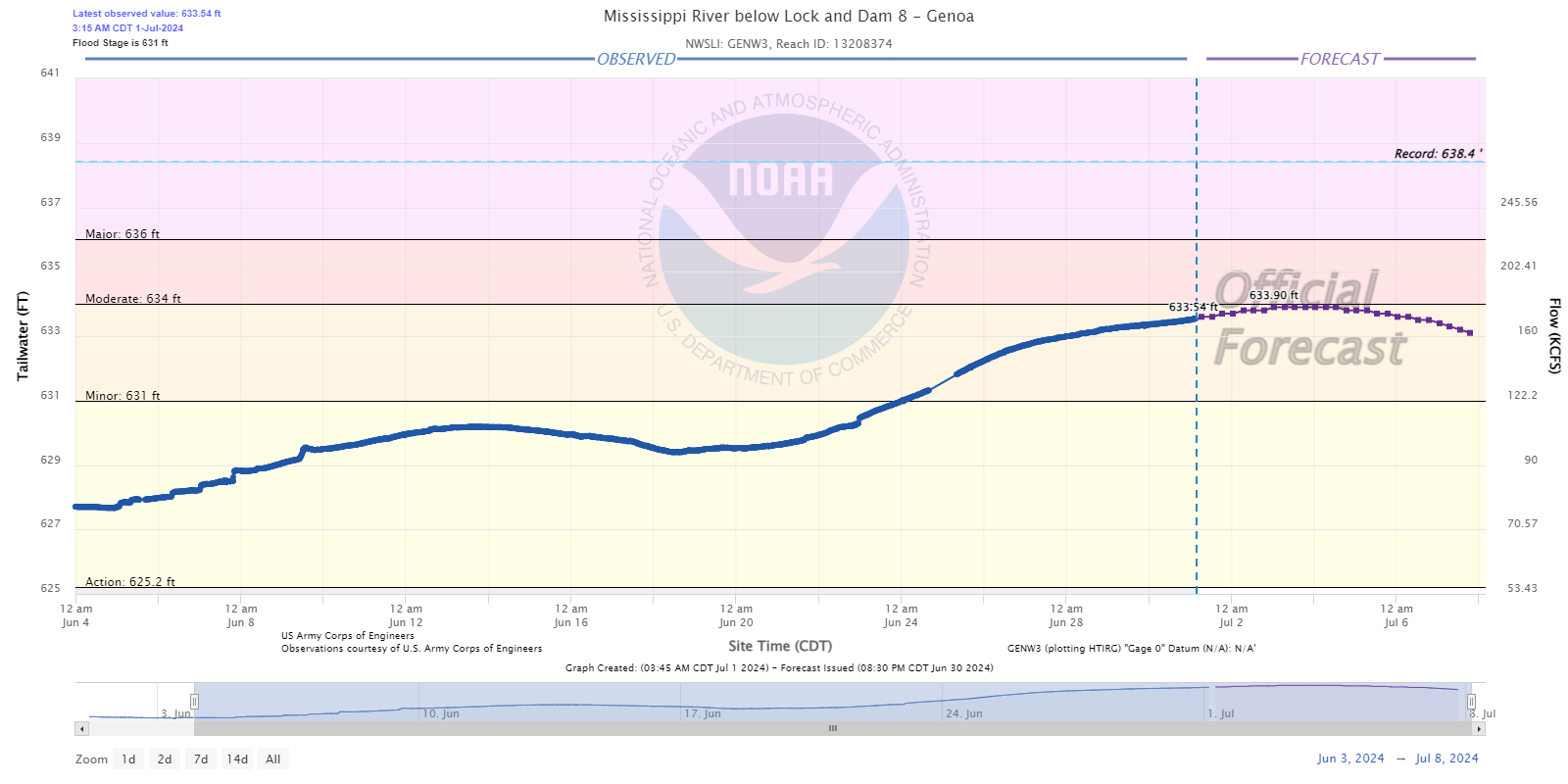
Mississippi River at Genoa, WI |
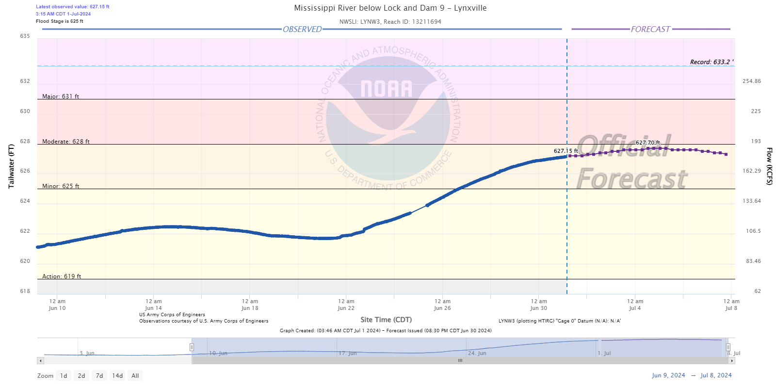
Mississippi River at Lynxville, WI |
 |
 |
.png) |
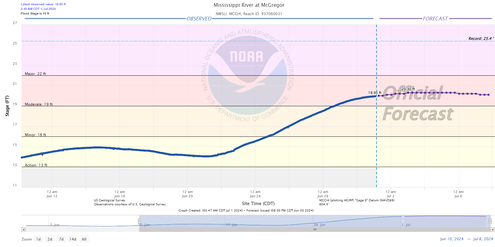
| Mississippi River at McGregor, IA |
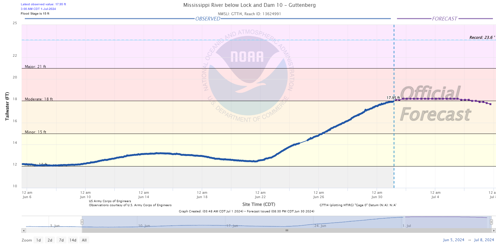
Mississippi River at Guttenberg, IA |
Mississippi River at Dubuque, IA |
Black / Trempealeau River Basins
 at Black River Falls.png) |
 at Galesville.png) |
 |
| Black River at Black River Falls, WI |
Black River at Galesville, WI |
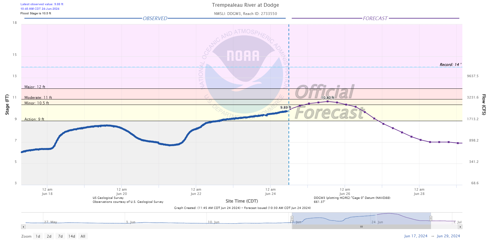
Trempealeau River at Dodge, WI |
Flood Photos
 |
 |
 |
 |
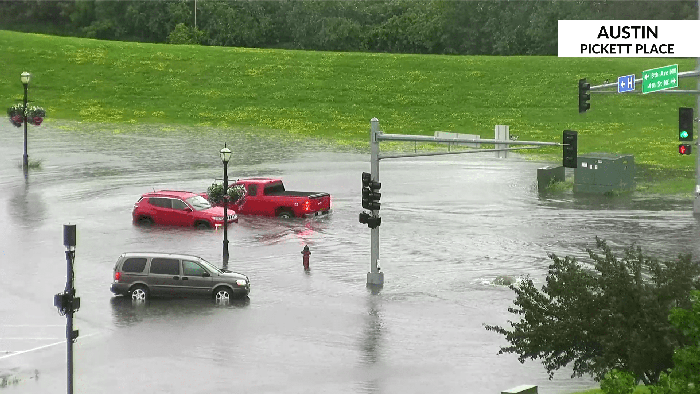
| Street flooding in Austin, MN (KAAL TV) |
Flooding along County Hwy M near Tomah, WI (Monroe Co. Emerg Mgmt) |
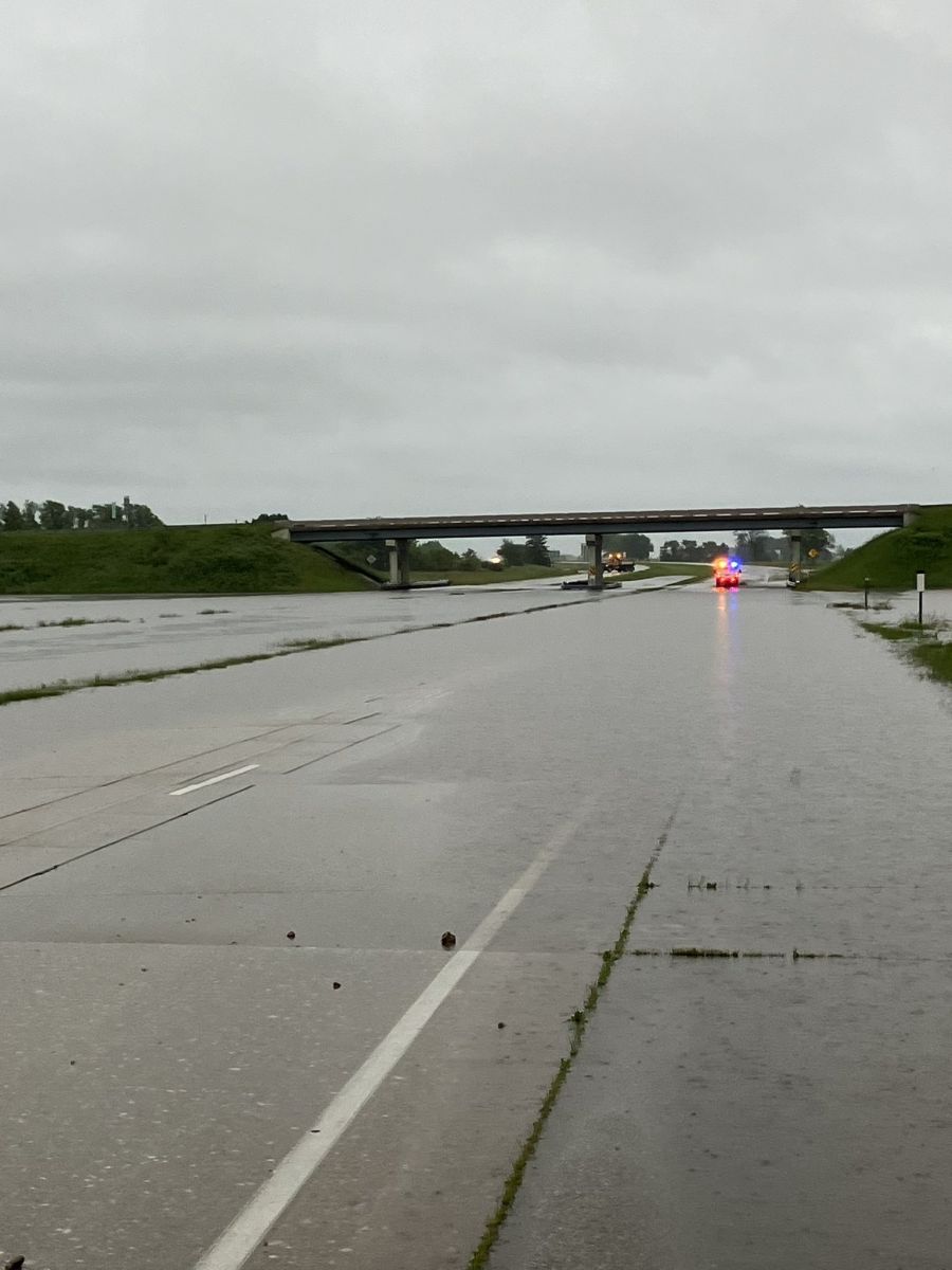
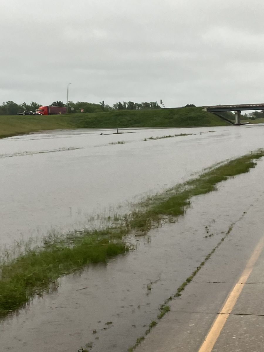
I-90 at Austin, MN (MNDOT) |
I-90 at Austin, MN (MNDOT) |
 |
 |
 |
 |
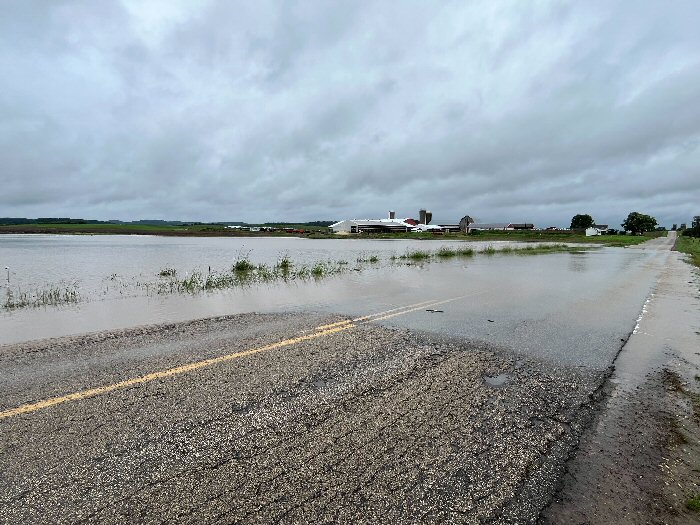
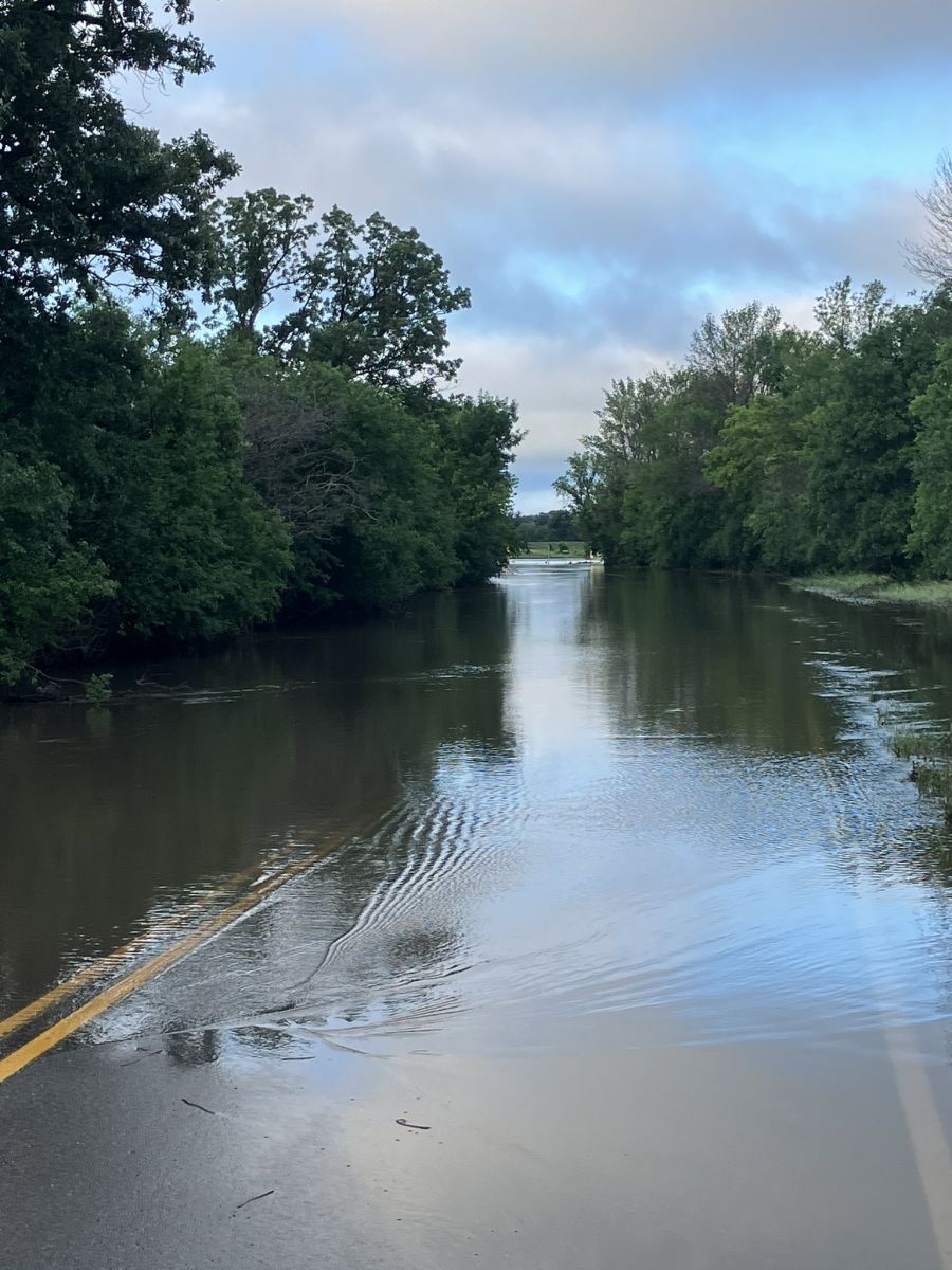
| Flooding south of Austin, MN (MNDOT) |
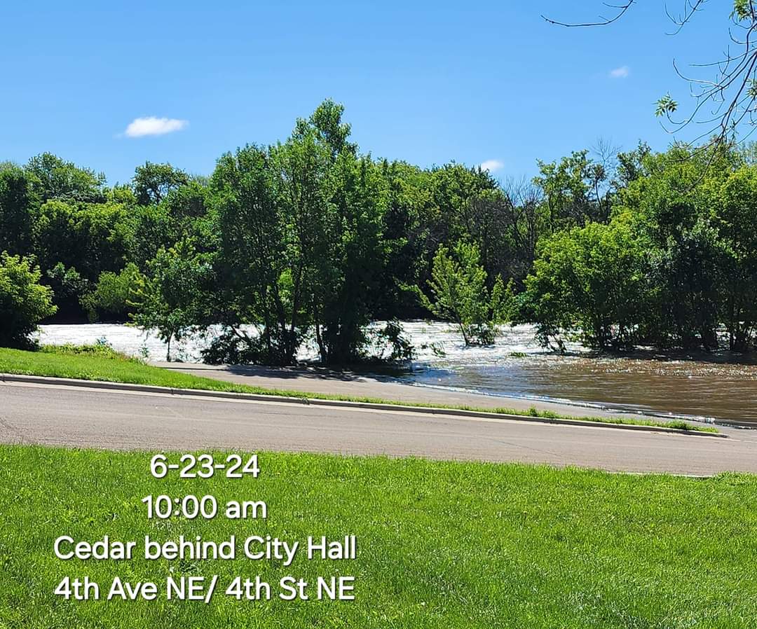
Flooding Cedar River behind City Hall 4th Ave NE/4th St NE (Kim Boyne) |
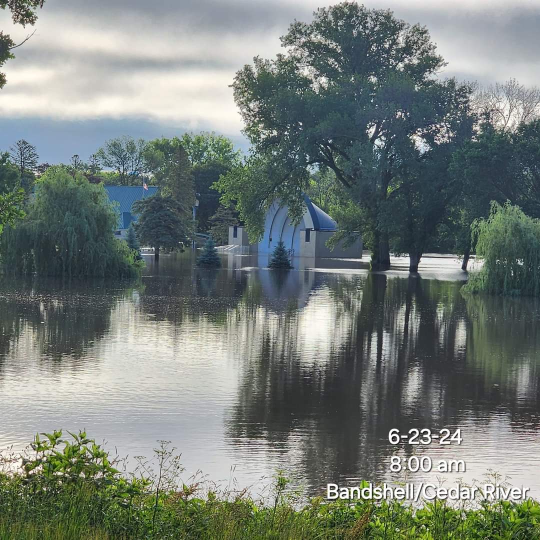
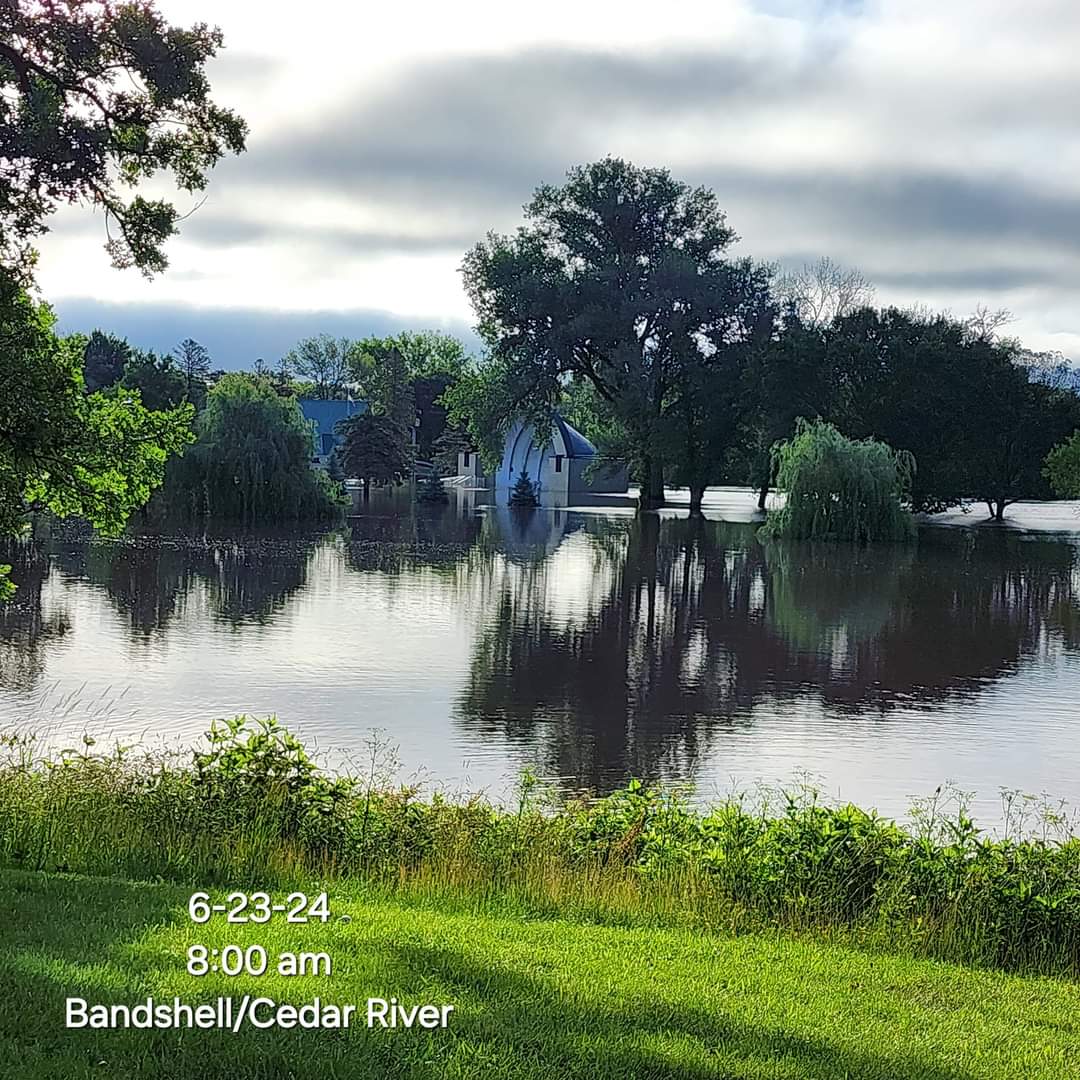
Flooding of the Bandshell by Cedar River (Kim Boyne) |
Flooding of the Bandshell by Cedar River (Kim Boyne) |
 |
 |
||
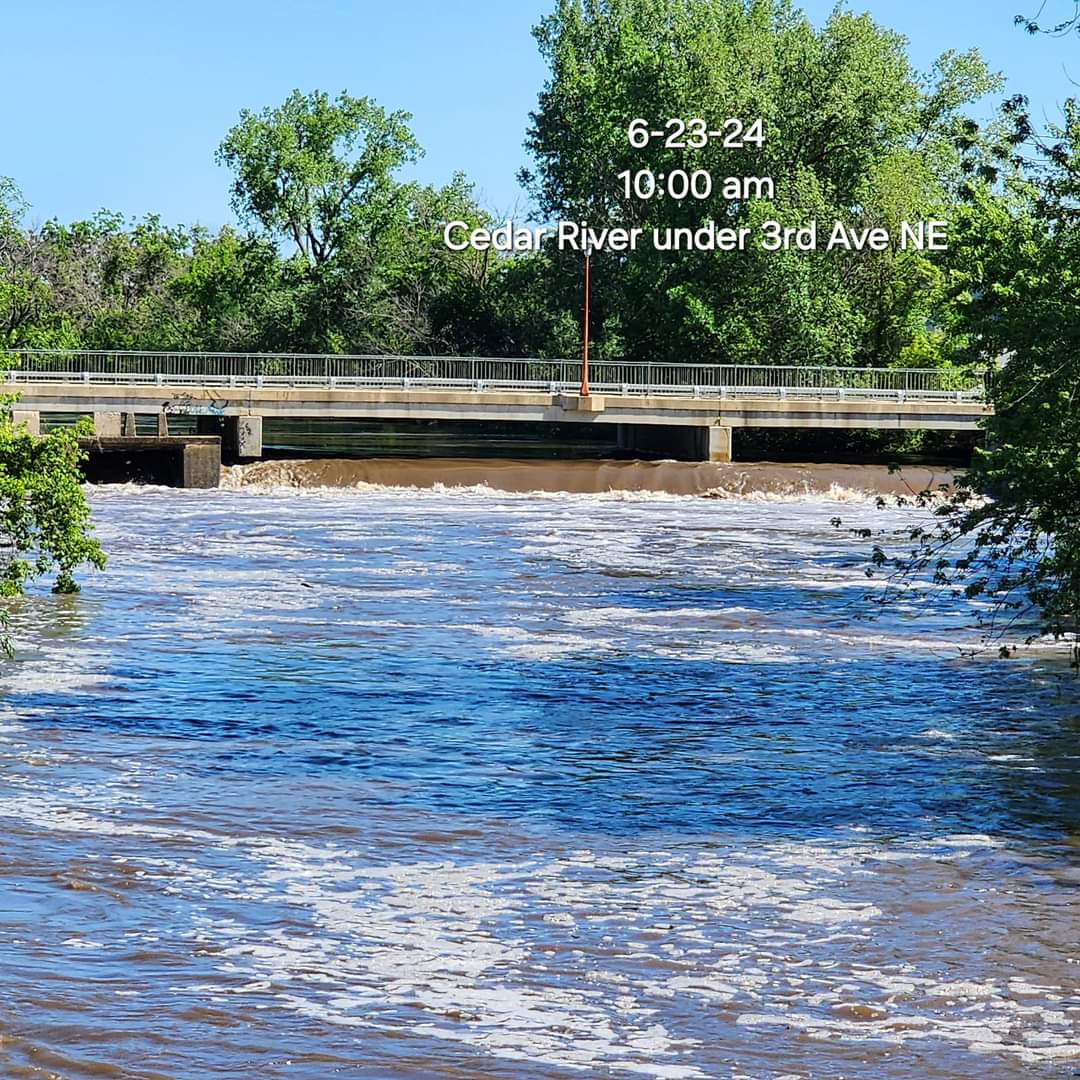
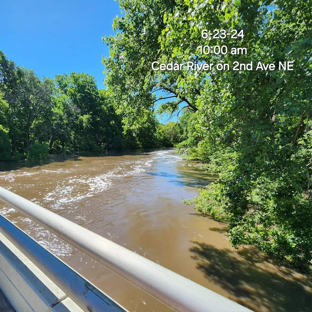
| Flooding of Cedar River on 2nd Ave NE (Kim Boyne) |
Flooding of Cedar River under 3rd Ave NE (Kim Boyne) |
Graphics / Service
 |
 |
 |
 |
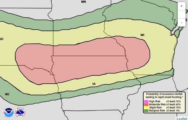
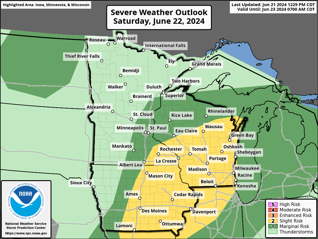
| Excessive Rainfall Outlook June 21-22 |
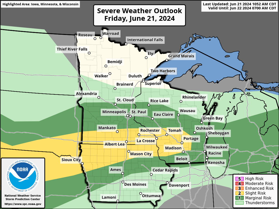
Severe Weather Outlook June 21 |
Severe Weather Outlook June 22 |
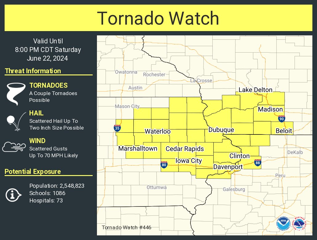
Tornado Watch June 22 |
 |
 |
 |
 |
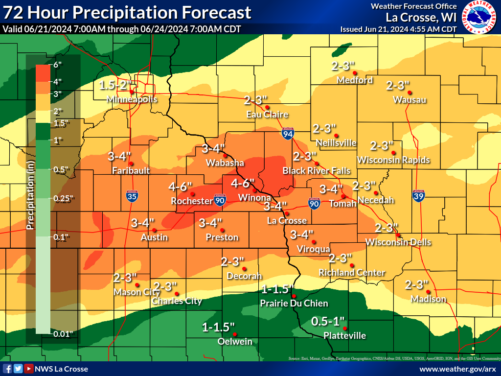
| Predicted Rainfall June 21-24 |
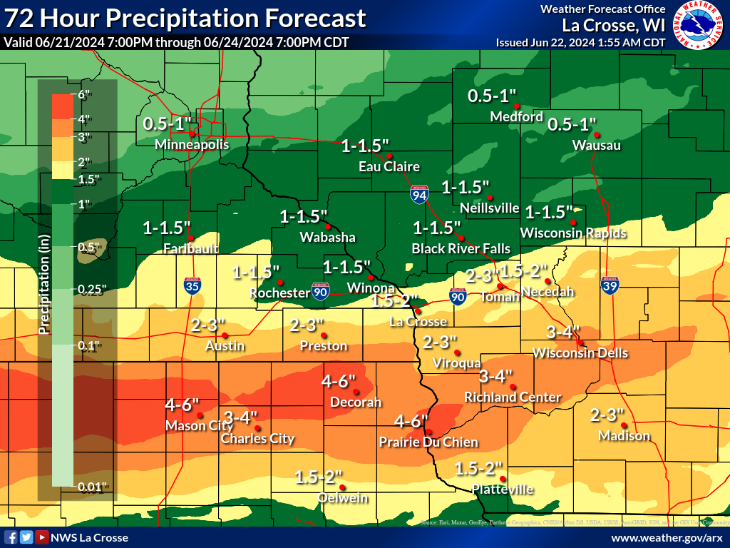
Predicted Rainfall June 22-25 |
Flood Watch Evolution | River forecast for the Cedar river at Charles City IA from Friday June 21 |
Radar:
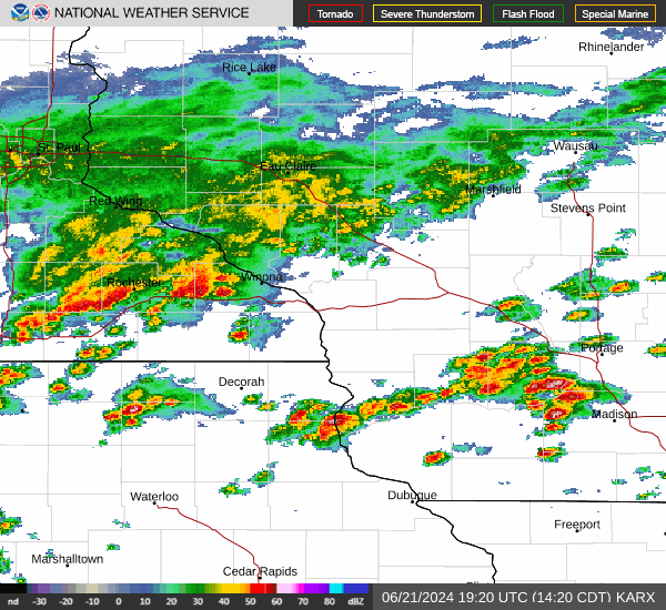 |
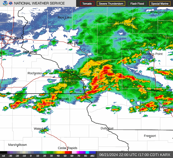 |
.gif) |
.gif) |
| June 21 (2:20-2:38 p.m.) | June 21 (5:00-5:18 p.m.) | June 22 (5:10-5:28 p.m.) | June 22 (5:40-5:58 p.m.) |
 |
|||
| Radar loop from June 22 |
Storm Reports
Preliminary Local Storm Report...Summary
National Weather Service La Crosse WI
823 PM CDT Sat Jun 22 2024

..TIME...   ...EVENT...      ...CITY LOCATION...     ...LAT.LON...
..DATE...   ....MAG....      ..COUNTY LOCATION..ST.. ...SOURCE....
            ..REMARKS..

0825 AM     Flood            4 NNE Tunnel City       44.06N 90.54W
06/22/2024                   Monroe             WI   Public

            County M is covered with water.

0951 AM     Flash Flood      1 N Hawkeye             42.95N 91.95W
06/22/2024                   Fayette            IA   Trained Spotter

            Flash flooding from near Hawkeye to West
            Union. Numerous roads under water.

0115 PM     Flood            5 N Elba                44.17N 92.00W
06/22/2024                   Winona             MN   Law Enforcement

            Water over Hwy 74 south of Beaver.

0120 PM     Flood            6 WNW Minneiska         44.22N 91.99W
06/22/2024                   Wabasha            MN   Trained Spotter

            Spotter reported water over County Rd 14.

0350 PM     Flood            Austin                  43.67N 92.98W
06/22/2024                   Mower              MN   Broadcast Media

            Street flooding reported in downtown Austin.
            Reported by KAAL.

0501 PM     Tstm Wnd Dmg     Dorchester              43.47N 91.51W
06/22/2024                   Allamakee          IA   Emergency Mngr

            Tree blown down.

0524 PM     Hail             Potosi                  42.69N 90.71W
06/22/2024  M0.25 Inch       Grant              WI   Emergency Mngr


0539 PM     Tstm Wnd Dmg     4 N Dickeyville         42.69N 90.58W
06/22/2024                   Grant              WI   Emergency Mngr

            Trees down over road and debris blocking
            roads around Cornelia. Possible tornado
            damage.

0600 PM     Flash Flood      3 SSE De Soto           43.38N 91.17W
06/22/2024                   Crawford           WI   Public

            Mudslides along Highway 35 near Lansing
            Bridge or Highway 82. Other mudslides
            reported in region as well.

0604 PM     Tstm Wnd Gst     4 S Mount Zion          43.20N 90.74W
06/22/2024  E50 MPH          Crawford           WI   Fire Dept/Rescue

            Reported by Boscobel Fire Dept via Grant Co.
            Emerg Mgmt.

0610 PM     Flash Flood      1 NNW Lansing           43.37N 91.23W
06/22/2024                   Allamakee          IA   Emergency Mngr

            Rock or mud slides along Highway 26 outside
            of Lansing.

0630 PM     Flash Flood      6 WNW Eastman           43.18N 91.13W
06/22/2024                   Crawford           WI   Law Enforcement

            Report from Crawford County Sheriff Dept of
            multiple water or mud over parts of Highway
            35 between Ferryville and Highway 82 going
            into Lansing IA.

0635 PM     Tstm Wnd Gst     2 W Livingston          42.90N 90.47W
06/22/2024  E52 MPH          Grant              WI   Fire Dept/Rescue


0638 PM     Flash Flood      4 WNW Ferryville        43.37N 91.14W
06/22/2024                   Crawford           WI   Dept of Highways

            Highway 35 closed. Flooding and mudslides
            across Highway 35, train stopped until
            tracks are cleared.

0745 PM     Flash Flood      5 NNE Fairview          43.43N 90.89W
06/22/2024                   Vernon             WI   Law Enforcement

            Reports of road closures due to water and
            debris over roads.


&&
Rainfall Reports
 |
 |
| Daily Rainfall Reports | Total Rainfall June 21-23 2024 |
Location                     Amount    Time/Date       Lat/Lon

...Iowa...

...Allamakee County...
3 S Dorchester               0.08 in   1100 AM 06/21   43.42N/91.51W
Lansing 4.1 NW               0.06 in   0700 AM 06/21   43.40N/91.29W
Harpers Ferry 6.4 SSW        0.03 in   0700 AM 06/21   43.11N/91.20W
Postville 5.5 NE             0.01 in   0700 AM 06/21   43.14N/91.49W

...Clayton County...
Guttenberg Dam 10            0.15 in   0600 AM 06/21   42.79N/91.10W
McGregor 6.4 WNW             0.03 in   0709 AM 06/21   43.07N/91.29W
Strawberry Point             0.03 in   0700 AM 06/21   42.69N/91.53W
Littleport                   0.02 in   1045 AM 06/21   42.75N/91.37W
1 WSW Marquette              0.01 in   1100 AM 06/21   43.04N/91.21W

...Fayette County...
Oelwein 1 E                  0.03 in   0630 AM 06/21   42.68N/91.88W
Waucoma 1 WNW                0.01 in   0700 AM 06/21   43.06N/92.05W

...Howard County...
Lime Springs 1.5 N           0.02 in   0700 AM 06/21   43.47N/92.28W

...Winneshiek County...
7 ENE Decorah                0.11 in   0838 AM 06/21   43.34N/91.64W
Decorah 4.9SE                0.05 in   0700 AM 06/21   43.26N/91.70W

...Minnesota...

...Dodge County...
1 W Mantorville              2.15 in   0700 AM 06/21   44.07N/92.79W
Mantorville 1.1 SSE          1.88 in   0930 AM 06/21   44.05N/92.74W
Claremont 3.1 S              1.54 in   0700 AM 06/21   44.00N/92.99W
1 ESE Dodge Center           1.24 in   0730 AM 06/21   44.02N/92.82W
Mantorville 1.9 ESE          1.14 in   0700 AM 06/21   44.05N/92.72W
Claremont 2.5 ESE            1.04 in   0700 AM 06/21   44.04N/92.95W
Kasson 5.7 SE                1.02 in   0930 AM 06/21   43.96N/92.68W
Hayfield 0.7 SSE             0.39 in   0730 AM 06/21   43.88N/92.84W
Hayfield 0.3 SSE             0.38 in   0630 AM 06/21   43.89N/92.85W

...Fillmore County...
Lanesboro                    0.04 in   1130 AM 06/21   43.72N/91.98W
Harmony 0.3 S                0.03 in   0700 AM 06/21   43.55N/92.01W
6 N Spring Valley            0.03 in   0700 AM 06/21   43.78N/92.39W
Mabel                        0.02 in   0615 AM 06/21   43.52N/91.76W
1 NNW Fillmore               0.01 in   1130 AM 06/21   43.76N/92.27W
Preston 3.2 NNE              0.01 in   0700 AM 06/21   43.71N/92.05W

...Houston County...
Eitzen 3.8 E                 0.06 in   0700 AM 06/21   43.50N/91.39W
Houston 8.6 WSW              0.05 in   0530 AM 06/21   43.69N/91.72W
Houston 5.3 SW               0.03 in   0515 AM 06/21   43.71N/91.65W
Caledonia 7.7 SE             0.02 in   0800 AM 06/21   43.57N/91.38W

...Mower County...
Lansing - Cedar River        0.88 in   1130 AM 06/21   43.75N/92.96W
Austin 1.9 ENE               0.85 in   0800 AM 06/21   43.68N/92.94W
Waltham 2.9 SW               0.75 in   0800 AM 06/21   43.79N/92.91W
Waltham 2.0 SE               0.51 in   0800 AM 06/21   43.80N/92.85W
Austin Waste Water Treatment 0.47 in   0700 AM 06/21   43.65N/92.97W
Austin 1.4 S                 0.46 in   0700 AM 06/21   43.65N/92.98W
Austin 1.1 ESE               0.43 in   0700 AM 06/21   43.67N/92.95W
Austin 1.5 WSW               0.40 in   0700 AM 06/21   43.67N/93.00W
Austin 3 NW - Turtle Creek   0.13 in   1130 AM 06/21   43.65N/92.98W

...Olmsted County...
6 NNW Genoa                  2.22 in   1100 AM 06/21   44.19N/92.65W
1 W Oronoco                  1.97 in   1130 AM 06/21   44.17N/92.55W
Rochester 6.9 NNE            1.70 in   1000 AM 06/21   44.11N/92.43W
Rochester 3.9 NNW            1.39 in   0800 AM 06/21   44.07N/92.51W
Rochester 5.8 ENE            1.05 in   0700 AM 06/21   44.06N/92.38W
Rochester 2.4 WNW            1.05 in   1117 AM 06/21   44.03N/92.53W
Rochester 2.4 WNW            1.00 in   0800 AM 06/21   44.02N/92.53W
Rochester 3.0 N              0.98 in   0700 AM 06/21   44.06N/92.47W
Rochester 4.7 ENE            0.96 in   0918 AM 06/21   44.04N/92.39W
Elgin 2SSW                   0.94 in   0700 AM 06/21   44.10N/92.27W
3 ENE Rochester              0.88 in   1130 AM 06/21   44.03N/92.43W
Rochester 3.5 NW             0.86 in   0730 AM 06/21   44.05N/92.53W
Rochester 5.9 E              0.85 in   0826 AM 06/21   44.00N/92.36W
3 W Rochester                0.81 in   1130 AM 06/21   44.02N/92.53W
Rochester 1.6 ENE            0.80 in   0800 AM 06/21   44.03N/92.45W
Rochester International Airp 0.78 in   1054 AM 06/21   43.90N/92.50W
Rochester 1.3 ENE            0.78 in   0700 AM 06/21   44.02N/92.45W
2 NNW Rochester              0.76 in   0700 AM 06/21   44.05N/92.49W
Rochester-Beltline Bear Cree 0.72 in   1130 AM 06/21   44.01N/92.45W
Byron 0.4 SSE                0.70 in   0656 AM 06/21   44.03N/92.64W
Stewartville 0.8 E           0.67 in   0739 AM 06/21   43.86N/92.47W
Rochester 4.7 N              0.64 in   0700 AM 06/21   44.08N/92.48W
Rochester 3.1 SW             0.59 in   0700 AM 06/21   43.98N/92.52W
Byron 3.6 NNE                0.55 in   0615 AM 06/21   44.09N/92.61W
Rochester 4.2 N              0.55 in   0604 AM 06/21   44.08N/92.49W
Rochester AP 2NE             0.46 in   0700 AM 06/21   43.93N/92.48W
Oronoco 3.3 ESE              0.45 in   0700 AM 06/21   44.14N/92.48W
Rochester-Cascade Creek      0.44 in   1130 AM 06/21   44.03N/92.47W
Eyota 2NE                    0.42 in   1130 AM 06/21   44.02N/92.20W
2 W High Forest              0.38 in   0700 AM 06/21   43.85N/92.59W
1 W Chester                  0.38 in   0619 AM 06/21   44.00N/92.38W
Rochester 3.9 ESE            0.38 in   0700 AM 06/21   43.99N/92.41W
5 WSW Rochester              0.36 in   1100 AM 06/21   43.98N/92.56W
Rochester 5.1 S              0.35 in   0700 AM 06/21   43.94N/92.48W
Byron 5.5 SE                 0.34 in   0705 AM 06/21   43.97N/92.58W
2 NE Rochester               0.17 in   0600 AM 06/21   44.04N/92.44W
Rochester 1.5 WSW            0.15 in   0600 AM 06/21   44.00N/92.50W

...Wabasha County...
Elgin 0.4 WNW                2.05 in   0630 AM 06/21   44.13N/92.26W
Mazeppa 3.3 SSE              1.85 in   0900 AM 06/21   44.23N/92.51W
Theilman 1 SSW               1.46 in   0730 AM 06/21   44.28N/92.19W
1 N Kellogg                  1.44 in   1100 AM 06/21   44.32N/92.00W
3 ESE Mazeppa                1.41 in   1130 AM 06/21   44.26N/92.49W
Lake City 9.7 SW             1.18 in   0700 AM 06/21   44.34N/92.41W
Lake City 0.7 SE             0.50 in   0800 AM 06/21   44.43N/92.27W
Wabasha 6.2 WNW              0.45 in   0700 AM 06/21   44.39N/92.16W
Lake City 0.9 NNE            0.43 in   0700 AM 06/21   44.45N/92.27W
Lake City 0.9 E              0.43 in   0800 AM 06/21   44.44N/92.26W

...Winona County...
Beaver                       1.17 in   1045 AM 06/21   44.15N/92.00W
1 WSW Elba                   0.92 in   1045 AM 06/21   44.09N/92.03W
3 SW Elba                    0.62 in   1130 AM 06/21   44.06N/92.05W
Whitewater State Park        0.49 in   1130 AM 06/21   44.05N/92.05W
Lewiston 0.2 NW              0.04 in   0700 AM 06/21   43.99N/91.87W
Altura 0.7 NNE               0.03 in   0700 AM 06/21   44.07N/91.94W
Dakota                       0.02 in   1115 AM 06/21   43.91N/91.36W
Winona 6.9 ESE               0.02 in   0700 AM 06/21   44.00N/91.55W
3 NE Nodine                  0.01 in   1130 AM 06/21   43.94N/91.41W
Winona 1.9 ESE               0.01 in   0724 AM 06/21   44.04N/91.63W
4.2 N Rollingstone           0.01 in   0600 AM 06/21   44.16N/91.81W

...Wisconsin...

...Adams County...
Nekoosa 8.0 SSE              0.18 in   0700 AM 06/21   44.21N/89.85W
0.6 W Friendship             0.05 in   0700 AM 06/21   43.98N/89.83W
Oxford 4.0 W                 0.04 in   0700 AM 06/21   43.79N/89.64W
Oxford 4.3 W                 0.03 in   0800 AM 06/21   43.79N/89.65W
Friendship 6.4 NNE           0.03 in   0700 AM 06/21   44.06N/89.79W

...Buffalo County...
Mondovi 12.1 SSE             0.04 in   0700 AM 06/21   44.40N/91.60W
Independence 9.1 NW          0.04 in   0700 AM 06/21   44.46N/91.55W
Dodge                        0.03 in   1045 AM 06/21   44.13N/91.55W
Cochrane 4.2 NE              0.01 in   0645 AM 06/21   44.27N/91.77W

...Clark County...
COLBY                        0.45 in   1137 AM 06/21   44.91N/90.32W
Greenwood 0.6 NNW            0.05 in   0700 AM 06/21   44.77N/90.60W
Thorp 10.1 S                 0.03 in   0600 AM 06/21   44.81N/90.82W
Thorp 0.5 NNE                0.02 in   0530 AM 06/21   44.97N/90.80W

...Crawford County...
Steuben 4SE                  0.14 in   0725 AM 06/21   43.13N/90.84W
Steuben                      0.05 in   1045 AM 06/21   43.18N/90.86W
0.6 NE Prairie Du Chien      0.03 in   0700 AM 06/21   43.05N/91.13W
Eastman 2.4 NNE              0.01 in   0700 AM 06/21   43.20N/91.00W

...Grant County...
1 NE Platteville             0.10 in   0600 AM 06/21   42.75N/90.46W
Patch Grove 0.1 NNW          0.04 in   0700 AM 06/21   42.94N/90.97W
Cassville 7.8 ENE            0.04 in   0700 AM 06/21   42.75N/90.84W
4.3 W Lancaster              0.03 in   0800 AM 06/21   42.83N/90.79W
Prairie Du Chien 9.9 SE      0.03 in   0700 AM 06/21   42.95N/90.99W
Bloomington 3.5 N            0.02 in   0643 AM 06/21   42.94N/90.92W
Dickeyville 0.1 SW           0.02 in   0700 AM 06/21   42.62N/90.59W

...Juneau County...
NECEDAH NWR RY DAM NECEDAH 5 1.71 in   1110 AM 06/21   44.06N/90.17W

...Monroe County...
Tomah 7.5 SSW                0.02 in   0700 AM 06/21   43.90N/90.58W

...Richland County...
Hillsboro 10.7 SW            0.02 in   0700 AM 06/21   43.55N/90.49W
Cazenovia 4.4 SSW            0.01 in   0700 AM 06/21   43.47N/90.23W

...Trempealeau County...
Blair (IFLOWS)               1.93 in   0955 AM 06/21   44.30N/91.23W
Courtland 0.3 SW             1.43 in   0700 AM 06/21   44.27N/91.35W
Whitehall (IFLOWS)           1.37 in   0947 AM 06/21   44.37N/91.32W
0.8 SW Pigeon Falls (IFLOWS) 1.06 in   0955 AM 06/21   44.42N/91.22W

...Vernon County...
0.5 E Viroqua                0.10 in   0700 AM 06/21   43.56N/90.88W
Viroqua 0.8 ESE              0.07 in   0700 AM 06/21   43.55N/90.87W
Ontario                      0.05 in   1000 AM 06/21   43.72N/90.59W

Observations are collected from a variety of sources with varying
equipment and exposures. We thank all volunteer weather observers
for their dedication. Not all data listed are considered official.
Location                     Amount    Time/Date       Lat/Lon

...Iowa...

...Allamakee County...
Harpers Ferry 6.4 SSW        1.41 in   0700 AM 06/22   43.11N/91.20W
Postville 5.5 NE             1.29 in   0700 AM 06/22   43.14N/91.49W
Lansing 4.1 NW               1.24 in   0700 AM 06/22   43.40N/91.29W
Monona 9.8 N                 1.07 in   0700 AM 06/22   43.19N/91.35W
3 S Dorchester               0.84 in   0800 AM 06/22   43.42N/91.51W

...Chickasaw County...
New Hampton 0.4 SW           3.44 in   0700 AM 06/22   43.06N/92.32W
New Hampton                  3.40 in   0700 AM 06/22   43.06N/92.32W
Ionia 2W                     2.05 in   0700 AM 06/22   43.03N/92.50W

...Clayton County...
McGregor 6.4 WNW             1.93 in   0714 AM 06/22   43.07N/91.29W
Monona 0.2 WNW               1.49 in   0630 AM 06/22   43.05N/91.39W
1 WSW Marquette              1.44 in   0900 AM 06/22   43.04N/91.21W
Littleport                   1.33 in   0845 AM 06/22   42.75N/91.37W
Strawberry Point             1.08 in   0700 AM 06/22   42.69N/91.53W
Big Spring Fish Hatchery     0.68 in   0900 AM 06/22   42.91N/91.47W
Guttenberg Dam 10            0.53 in   0600 AM 06/22   42.79N/91.10W

...Fayette County...
West Union                   3.20 in   0900 AM 06/22
Fayette                      3.00 in   0700 AM 06/22   42.88N/91.83W
Oelwein 1 E                  2.80 in   0630 AM 06/22   42.68N/91.88W
Fayette 3 SSE                2.70 in   0900 AM 06/22
Waucoma 3.2 S                1.87 in   0818 AM 06/22   43.01N/92.03W

...Howard County...
Lime Springs 1.5 N           2.08 in   0700 AM 06/22   43.47N/92.28W
Elma                         1.96 in   0700 AM 06/22   43.24N/92.44W

...Mitchell County...
Osage 4.7 E                  2.50 in   0700 AM 06/22   43.28N/92.72W
Osage                        2.50 in   0700 AM 06/22   43.28N/92.81W
St Ansgar                    2.43 in   0630 AM 06/22   43.38N/92.92W
Osage 0.6 ENE                2.12 in   0700 AM 06/22   43.29N/92.80W

...Winneshiek County...
Decorah 4.9SE                1.86 in   0830 AM 06/22   43.26N/91.70W
7 ENE Decorah                1.83 in   0828 AM 06/22   43.34N/91.64W

...Minnesota...

...Dodge County...
Kasson 5.7 SE                4.08 in   0830 AM 06/22   43.96N/92.68W
Hayfield 0.3 SSE             3.41 in   0630 AM 06/22   43.89N/92.85W
Hayfield 0.6 WNW             3.33 in   0700 AM 06/22   43.89N/92.86W
Mantorville 1.9 ESE          2.19 in   0700 AM 06/22   44.05N/92.72W
Claremont 2.5 ESE            2.01 in   0700 AM 06/22   44.04N/92.95W
Claremont 3.1 S              1.95 in   0700 AM 06/22   44.00N/92.99W

...Fillmore County...
1 NNW Fillmore               5.83 in   0830 AM 06/22   43.76N/92.27W
Wykoff 3.1 NW                5.61 in   0700 AM 06/22   43.74N/92.31W
Chatfield 6.3 ESE            4.89 in   0700 AM 06/22   43.81N/92.08W
Chatfield 9.0 ESE            4.67 in   0700 AM 06/22   43.79N/92.03W
Spring Valley                3.87 in   0700 AM 06/22   43.69N/92.39W
6 N Spring Valley            3.60 in   0700 AM 06/22   43.78N/92.39W
Preston 3.2 NNE              2.87 in   0700 AM 06/22   43.71N/92.05W
Preston 2.7 NE               2.50 in   0700 AM 06/22   43.70N/92.05W
Lanesboro 0.2 SSW            2.39 in   0600 AM 06/22   43.72N/91.97W
Lanesboro                    1.74 in   0830 AM 06/22   43.72N/91.98W
Harmony 0.3 S                1.40 in   0700 AM 06/22   43.55N/92.01W
Mabel                        1.21 in   0700 AM 06/22   43.52N/91.76W

...Houston County...
Houston 2.3 NNW              2.27 in   0800 AM 06/22   43.79N/91.59W
Mound Prairie                2.14 in   0845 AM 06/22   43.78N/91.45W
Hokah 4 NW                   1.94 in   0700 AM 06/22   43.80N/91.43W
1 ENE Mound Prairie          1.94 in   0700 AM 06/22   43.79N/91.42W
La Crescent 1.0 WSW          1.37 in   0700 AM 06/22   43.83N/91.32W
Eitzen 3.8 E                 1.23 in   0730 AM 06/22   43.50N/91.39W
Caledonia 5.4 S              1.04 in   0800 AM 06/22   43.56N/91.51W
Caledonia 7.7 SE             0.92 in   0800 AM 06/22   43.57N/91.38W
Caledonia                    0.82 in   0700 AM 06/22   43.63N/91.50W
Caledonia 5.3 NNE            0.74 in   0600 AM 06/22   43.71N/91.46W

...Mower County...
Austin 4 WSW                 4.87 in   0700 AM 06/22
Austin 1.4 S                 4.83 in   0700 AM 06/22   43.65N/92.98W
Austin 1.5 WSW               4.32 in   0700 AM 06/22   43.67N/93.00W
Austin 1.1 ESE               4.25 in   0700 AM 06/22   43.67N/92.95W
Grand Meadow                 4.10 in   0530 AM 06/22   43.71N/92.56W
Austin 2.4 W                 3.95 in   0615 AM 06/22   43.67N/93.02W
Austin 1.9 ENE               3.85 in   0800 AM 06/22   43.68N/92.94W
Lansing - Cedar River        2.43 in   0830 AM 06/22   43.75N/92.96W
Waltham 2.9 SW               1.71 in   0800 AM 06/22   43.79N/92.91W
Austin 3 NW - Turtle Creek   1.29 in   0830 AM 06/22   43.65N/92.98W

...Olmsted County...
Stewartville 4.3 E           4.56 in   0600 AM 06/22   43.86N/92.40W
Rochester 4.2 N              4.20 in   0600 AM 06/22   44.08N/92.49W
Rochester 5.6 E              4.15 in   0830 AM 06/22   44.00N/92.37W
Rochester 2.0 NNE            4.02 in   0700 AM 06/22   44.04N/92.47W
Rochester 4.7 N              4.01 in   0700 AM 06/22   44.08N/92.48W
1 W Chester                  3.87 in   0743 AM 06/22   44.00N/92.38W
Rochester 1.5 WSW            3.80 in   0600 AM 06/22   44.00N/92.50W
Rochester 3.9 ESE            3.66 in   0700 AM 06/22   43.99N/92.41W
Byron 5.5 SE                 3.52 in   0655 AM 06/22   43.97N/92.58W
Rochester 5.9 E              3.41 in   0856 AM 06/22   44.00N/92.36W
Chatfield 2.7 NNW            3.41 in   0800 AM 06/22   43.88N/92.22W
Rochester International Airp 3.40 in   0854 AM 06/22   43.90N/92.50W
2 NNW Rochester              3.40 in   0700 AM 06/22   44.05N/92.49W
Byron 3.6 NNE                3.40 in   0700 AM 06/22   44.09N/92.61W
Rochester 3.0 N              3.40 in   0700 AM 06/22   44.06N/92.47W
2 NE Rochester               3.36 in   0600 AM 06/22   44.04N/92.44W
Byron 0.4 SSE                3.31 in   0658 AM 06/22   44.03N/92.64W
Oronoco 3.3 ESE              3.31 in   0700 AM 06/22   44.14N/92.48W
Rochester 5.1 S              3.19 in   0700 AM 06/22   43.94N/92.48W
Rochester 3.1 SW             3.07 in   0700 AM 06/22   43.98N/92.52W
Rochester 3.5 NW             2.94 in   0700 AM 06/22   44.05N/92.53W
Rochester-Cascade Creek      2.91 in   0830 AM 06/22   44.03N/92.47W
2 W High Forest              2.88 in   0700 AM 06/22   43.85N/92.59W
Elgin 2SSW                   2.87 in   0700 AM 06/22   44.10N/92.27W
Rochester 2.1 S              2.82 in   0800 AM 06/22   43.99N/92.47W
Rochester 3.9 NNW            2.80 in   0800 AM 06/22   44.07N/92.51W
3 ENE Rochester              2.61 in   0830 AM 06/22   44.03N/92.43W
3 W Rochester                2.59 in   0830 AM 06/22   44.02N/92.53W
Rochester 1.6 ENE            2.38 in   0800 AM 06/22   44.03N/92.45W
Rochester-Beltline Bear Cree 2.35 in   0830 AM 06/22   44.01N/92.45W
5 WSW Rochester              2.22 in   0900 AM 06/22   43.98N/92.56W
Rochester 2.4 WNW            1.82 in   0800 AM 06/22   44.02N/92.53W
Elba 4.7 SW                  1.78 in   0900 AM 06/22   44.04N/92.09W
1 W Oronoco                  1.70 in   0830 AM 06/22   44.17N/92.55W
6 NNW Genoa                  1.56 in   0900 AM 06/22   44.19N/92.65W
Saint Charles 7.6 NNW        1.38 in   0900 AM 06/22   44.08N/92.10W

...Wabasha County...
Elgin 0.4 WNW                3.90 in   0630 AM 06/22   44.13N/92.26W
Kellogg 0.1 N                3.07 in   0630 AM 06/22   44.31N/92.00W
Lake City 0.9 NNE            2.76 in   0700 AM 06/22   44.45N/92.27W
Wabasha 6.2 WNW              2.66 in   0700 AM 06/22   44.39N/92.16W
Lake City 0.7 SE             2.60 in   0800 AM 06/22   44.43N/92.27W
Lake City 0.9 E              2.16 in   0800 AM 06/22   44.44N/92.26W
Lake City 9.7 SW             2.12 in   0700 AM 06/22   44.34N/92.41W
Zumbro Falls 3.5 SSW         2.06 in   0730 AM 06/22   44.24N/92.46W
3 ESE Mazeppa                1.67 in   0830 AM 06/22   44.26N/92.49W
Theilman 1 SSW               1.23 in   0730 AM 06/22   44.28N/92.19W
1 N Kellogg                  1.11 in   0900 AM 06/22   44.32N/92.00W

...Winona County...
Winona 4 SW                  4.65 in   0700 AM 06/22
Winona 2.0 ESE               4.37 in   0700 AM 06/22   44.04N/91.63W
Winona 1.9 ESE               4.33 in   0725 AM 06/22   44.04N/91.63W
Winona 6.9 ESE               4.23 in   0700 AM 06/22   44.00N/91.55W
4.2 N Rollingstone           3.90 in   0700 AM 06/22   44.16N/91.81W
Minneiska 1.1 SW             3.82 in   0700 AM 06/22   44.18N/91.88W
Lewiston 0.2 NW              3.81 in   0700 AM 06/22   43.99N/91.87W
Winona 5.1 WSW               3.53 in   0630 AM 06/22   44.03N/91.77W
Altura 0.7 NNE               3.22 in   0700 AM 06/22   44.07N/91.94W
Lewiston 9.1 SSE             3.21 in   0700 AM 06/22   43.86N/91.80W
Whitewater State Park        2.95 in   0830 AM 06/22   44.05N/92.05W
Goodview                     2.80 in   1000 AM 06/22
1 WSW Elba                   2.70 in   0845 AM 06/22   44.09N/92.03W
3 SW Elba                    2.49 in   0830 AM 06/22   44.06N/92.05W
Beaver                       2.18 in   0845 AM 06/22   44.15N/92.00W
La Crescent 4.0 NNW          1.82 in   0708 AM 06/22   43.88N/91.34W
3 NE Nodine                  1.05 in   0830 AM 06/22   43.94N/91.41W
Dakota                       0.14 in   0915 AM 06/22   43.91N/91.36W

...Wisconsin...

...Adams County...
Nekoosa 8.0 SSE              2.53 in   0700 AM 06/22   44.21N/89.85W
0.6 W Friendship             1.73 in   0700 AM 06/22   43.98N/89.83W
Friendship 6.4 NNE           1.59 in   0700 AM 06/22   44.06N/89.79W
Oxford 4.0 W                 0.78 in   0700 AM 06/22   43.79N/89.64W

...Buffalo County...
Cochrane 0.6 ESE             3.83 in   0700 AM 06/22   44.23N/91.82W
Cochrane 4.2 NE              3.65 in   0705 AM 06/22   44.27N/91.77W
Mondovi 12.1 SSE             2.64 in   0724 AM 06/22   44.40N/91.60W
Independence 9.1 NW          1.96 in   0700 AM 06/22   44.46N/91.55W

...Clark County...
Greenwood 0.6 NNW            1.97 in   0700 AM 06/22   44.77N/90.60W
Thorp 0.5 NNE                1.61 in   0605 AM 06/22   44.97N/90.80W
Thorp 10.1 S                 1.58 in   0600 AM 06/22   44.81N/90.82W
COLBY                        1.14 in   0918 AM 06/22   44.91N/90.32W

...Crawford County...
Steuben                      3.52 in   0845 AM 06/22   43.18N/90.86W
Eastman 2.4 NNE              2.61 in   0700 AM 06/22   43.20N/91.00W
Gays Mills                   2.53 in   0730 AM 06/22   43.32N/90.85W
Gays Mills 1.0 NE            2.26 in   0700 AM 06/22   43.33N/90.84W
2.8 E Harpers Ferry          1.96 in   0915 AM 06/22   43.21N/91.10W
Steuben 4SE                  1.28 in   0637 AM 06/22   43.13N/90.84W

...Grant County...
Town of Woodman              2.90 in   0700 AM 06/22
Stitzer 1.8 SE               1.20 in   0700 AM 06/22   42.91N/90.60W
Prairie Du Chien 9.9 SE      0.25 in   0700 AM 06/22   42.95N/90.99W
Patch Grove 0.1 NNW          0.24 in   0700 AM 06/22   42.94N/90.97W
Bloomington 3.5 N            0.18 in   0654 AM 06/22   42.94N/90.92W
Dickeyville 0.1 SW           0.12 in   0845 AM 06/22   42.62N/90.59W
1 NE Platteville             0.08 in   0600 AM 06/22   42.75N/90.46W

...Jackson County...
Melrose 3.6 W                2.77 in   0630 AM 06/22   44.13N/91.07W

...Juneau County...
NECEDAH NWR RY DAM NECEDAH 5 4.54 in   0910 AM 06/22   44.06N/90.17W
1.0 E Mauston                1.37 in   0800 AM 06/22   43.79N/90.06W
3 ESE Lemonweir              0.99 in   0530 AM 06/22   43.77N/89.96W
0.6 W Necedah                0.09 in   0848 AM 06/22   44.02N/90.08W

...La Crosse County...
Coon Valley 4.5 NNW          2.38 in   0700 AM 06/22   43.76N/91.06W
Viroqua 9.3 S                1.68 in   0600 AM 06/22   43.76N/91.06W
Holmen 2 S                   1.64 in   0700 AM 06/22   43.93N/91.25W
Holmen 1.7 SSE               1.64 in   0700 AM 06/22   43.93N/91.24W
La Crosse 4NNW               1.37 in   0730 AM 06/22   43.87N/91.27W
La Crosse 2.4 S              1.20 in   0800 AM 06/22   43.79N/91.23W
Onalaska 1.9 E               1.13 in   0700 AM 06/22   43.89N/91.18W
Onalaska 0.6 SW              1.11 in   0800 AM 06/22   43.88N/91.23W
Onalaska 0.5 WSW             1.05 in   0700 AM 06/22   43.89N/91.23W

...Monroe County...
Tomah 7.5 SSW                2.25 in   0830 AM 06/22   43.90N/90.58W
Warrens 4.7 WSW              2.20 in   0700 AM 06/22   44.10N/90.59W

...Richland County...
Richland Center 4 N          3.02 in   0700 AM 06/22   43.40N/90.39W
Hillsboro 10.7 SW            2.43 in   0705 AM 06/22   43.55N/90.49W
Cazenovia 4.4 SSW            0.72 in   0700 AM 06/22   43.47N/90.23W

...Taylor County...
Medford 0.8 ENE              1.16 in   0700 AM 06/22   45.14N/90.33W

...Trempealeau County...
4 NW Stevenstown             4.50 in   0800 AM 06/22   44.07N/91.23W
Blair (IFLOWS)               3.86 in   0819 AM 06/22   44.30N/91.23W
Trempealeau 7.6 NNW          3.70 in   0700 AM 06/22   44.11N/91.48W
1 NW Trempealeau             3.52 in   0700 AM 06/22   44.03N/91.46W
Ettrick 4.0 WNW              3.32 in   0657 AM 06/22   44.19N/91.34W
Galesville 4.7 E             2.90 in   0910 AM 06/22   44.08N/91.26W
Galesville 1.0 NE            2.22 in   0700 AM 06/22   44.10N/91.34W
Whitehall (IFLOWS)           2.05 in   0902 AM 06/22   44.37N/91.32W
Courtland 0.3 SW             1.96 in   0700 AM 06/22   44.27N/91.35W
0.8 SW Pigeon Falls (IFLOWS) 1.93 in   0845 AM 06/22   44.42N/91.22W
Osseo 0.4 E                  1.80 in   0600 AM 06/22   44.58N/91.21W

...Vernon County...
Stoddard 1.5 NE              2.63 in   0700 AM 06/22   43.67N/91.19W
0.5 E Viroqua                2.28 in   0700 AM 06/22   43.56N/90.88W
Ontario                      2.22 in   0800 AM 06/22   43.72N/90.59W
Stoddard 4.7 NNE             2.16 in   0700 AM 06/22   43.72N/91.17W
Viroqua 0.8 ESE              1.79 in   0700 AM 06/22   43.55N/90.87W
Genoa Dam 8                  0.91 in   0915 AM 06/22   43.57N/91.23W

Observations are collected from a variety of sources with varying
equipment and exposures. We thank all volunteer weather observers
for their dedication. Not all data listed are considered official.
Location                     Amount    Time/Date       Lat/Lon

...Iowa...

...Allamakee County...
Harpers Ferry 6.4 SSW        2.04 in   0700 AM 06/23   43.11N/91.20W
Lansing 4.1 NW               1.96 in   0700 AM 06/23   43.40N/91.29W
3 S Dorchester               1.19 in   1000 AM 06/23   43.42N/91.51W
Monona 9.8 N                 0.85 in   0700 AM 06/23   43.19N/91.35W

...Chickasaw County...
New Hampton 0.4 SW           0.81 in   0700 AM 06/23   43.06N/92.32W
Ionia 2W                     0.07 in   0700 AM 06/23   43.03N/92.50W

...Clayton County...
Monona 0.2 WNW               1.98 in   0630 AM 06/23   43.05N/91.39W
Guttenberg Dam 10            1.85 in   0600 AM 06/23   42.79N/91.10W
Strawberry Point             1.67 in   0700 AM 06/23   42.69N/91.53W
McGregor 6.4 WNW             1.63 in   0608 AM 06/23   43.07N/91.29W
Elkader 6SSW                 1.00 in   0700 AM 06/23   42.78N/91.45W
1 WSW Marquette              0.61 in   1000 AM 06/23   43.04N/91.21W
Littleport                   0.28 in   0945 AM 06/23   42.75N/91.37W

...Fayette County...
Oelwein 1 E                  2.12 in   0630 AM 06/23   42.68N/91.88W
Waucoma 3.2 S                0.63 in   0700 AM 06/23   43.01N/92.03W
Fayette                      0.50 in   0700 AM 06/23   42.88N/91.83W

...Howard County...
Lime Springs 1.5 N           1.62 in   0700 AM 06/23   43.47N/92.28W
Elma                         0.12 in   0700 AM 06/23   43.24N/92.44W

...Mitchell County...
St Ansgar                    1.02 in   0630 AM 06/23   43.38N/92.92W
Osage 4.7 E                  0.38 in   0700 AM 06/23   43.28N/92.72W
Osage                        0.23 in   0700 AM 06/23   43.28N/92.81W
Osage 0.6 ENE                0.22 in   0700 AM 06/23   43.29N/92.80W

...Winneshiek County...
7 ENE Decorah                1.47 in   0854 AM 06/23   43.34N/91.64W
Decorah 4.9SE                1.36 in   0700 AM 06/23   43.26N/91.70W
Fort Atkinson 2.6 W          1.00 in   0700 AM 06/23   43.15N/91.98W

...Minnesota...

...Dodge County...
Kasson 5.7 SE                0.51 in   0630 AM 06/23   43.96N/92.68W
Mantorville 1.9 ESE          0.50 in   0700 AM 06/23   44.05N/92.72W
Hayfield 0.3 SSE             0.49 in   0630 AM 06/23   43.89N/92.85W
Claremont 2.5 ESE            0.41 in   0700 AM 06/23   44.04N/92.95W
Claremont 3.1 S              0.39 in   0700 AM 06/23   44.00N/92.99W

...Fillmore County...
Mabel                        1.26 in   0630 AM 06/23   43.52N/91.76W
Harmony 0.3 S                1.13 in   0700 AM 06/23   43.55N/92.01W
6 N Spring Valley            0.64 in   0700 AM 06/23   43.78N/92.39W
Wykoff 3.1 NW                0.57 in   0700 AM 06/23   43.74N/92.31W
Spring Valley                0.41 in   0700 AM 06/23   43.69N/92.39W
Preston 2.7 NE               0.38 in   0700 AM 06/23   43.70N/92.05W
Preston 3.2 NNE              0.35 in   0700 AM 06/23   43.71N/92.05W
Lanesboro 0.2 SSW            0.30 in   0600 AM 06/23   43.72N/91.97W
Chatfield 9.0 ESE            0.23 in   0700 AM 06/23   43.79N/92.03W
1 NNW Fillmore               0.21 in   1030 AM 06/23   43.76N/92.27W
Lanesboro                    0.15 in   0930 AM 06/23   43.72N/91.98W

...Houston County...
Eitzen 3.8 E                 1.56 in   0700 AM 06/23   43.50N/91.39W
Caledonia 7.7 SE             1.42 in   0800 AM 06/23   43.57N/91.38W
Brownsville 3.8 SW           1.02 in   0700 AM 06/23   43.65N/91.32W
Caledonia                    0.85 in   0600 AM 06/23   43.63N/91.50W
Caledonia 5.3 NNE            0.75 in   0615 AM 06/23   43.71N/91.46W
Houston 6.9 E                0.43 in   0845 AM 06/23   43.76N/91.43W
Hokah 4 NW                   0.35 in   0700 AM 06/23   43.80N/91.43W
1 ENE Mound Prairie          0.35 in   0700 AM 06/23   43.79N/91.42W
Mound Prairie                0.31 in   0945 AM 06/23   43.78N/91.45W

...Mower County...
Austin 2.4 W                 1.31 in   0646 AM 06/23   43.67N/93.02W
Austin 1.4 S                 1.21 in   0700 AM 06/23   43.65N/92.98W
Austin 1.5 WSW               1.17 in   0700 AM 06/23   43.67N/93.00W
Grand Meadow                 0.95 in   0530 AM 06/23   43.71N/92.56W
Lansing - Cedar River        0.71 in   0930 AM 06/23   43.75N/92.96W
Austin 3 NW - Turtle Creek   0.62 in   0930 AM 06/23   43.65N/92.98W
Waltham 2.9 SW               0.55 in   0800 AM 06/23   43.79N/92.91W
Waltham 2.0 SE               0.37 in   0800 AM 06/23   43.80N/92.85W

...Olmsted County...
Rochester 3.1 SW             0.69 in   0700 AM 06/23   43.98N/92.52W
Rochester 3.9 NNW            0.60 in   0800 AM 06/23   44.07N/92.51W
Rochester 3.9 ESE            0.60 in   0700 AM 06/23   43.99N/92.41W
Rochester 5.6 E              0.57 in   0700 AM 06/23   44.00N/92.37W
Byron 5.5 SE                 0.56 in   0741 AM 06/23   43.97N/92.58W
Rochester 2.0 NNE            0.55 in   0700 AM 06/23   44.04N/92.47W
Rochester 3.5 NW             0.52 in   0700 AM 06/23   44.05N/92.53W
Rochester 2.4 WNW            0.51 in   0800 AM 06/23   44.03N/92.53W
Byron 0.4 SSE                0.50 in   0658 AM 06/23   44.03N/92.64W
Rochester 4.7 N              0.50 in   0700 AM 06/23   44.08N/92.48W
2 NNW Rochester              0.50 in   0700 AM 06/23   44.05N/92.49W
Rochester 1.5 WSW            0.50 in   0600 AM 06/23   44.00N/92.50W
Rochester 1.3 ENE            0.50 in   0700 AM 06/23   44.02N/92.45W
Rochester 1.6 ENE            0.49 in   0800 AM 06/23   44.03N/92.45W
Rochester-Beltline Bear Cree 0.48 in   0930 AM 06/23   44.01N/92.45W
2 NE Rochester               0.46 in   0600 AM 06/23   44.04N/92.44W
Rochester International Airp 0.45 in   0954 AM 06/23   43.90N/92.50W
3 W Rochester                0.45 in   0930 AM 06/23   44.02N/92.53W
3 ENE Rochester              0.45 in   0930 AM 06/23   44.03N/92.43W
Rochester 4.1 ENE            0.44 in   0830 AM 06/23   44.04N/92.40W
Rochester 6.9 NNE            0.44 in   0700 AM 06/23   44.11N/92.43W
5 WSW Rochester              0.44 in   1000 AM 06/23   43.98N/92.56W
Rochester-Cascade Creek      0.39 in   0930 AM 06/23   44.03N/92.47W
Oronoco 3.3 ESE              0.38 in   0700 AM 06/23   44.14N/92.48W
Rochester 5.1 S              0.37 in   0700 AM 06/23   43.94N/92.48W
Elgin 2SSW                   0.35 in   0700 AM 06/23   44.10N/92.27W
Rochester 5.6 S              0.32 in   0700 AM 06/23   43.93N/92.47W
Chatfield 2.7 NNW            0.25 in   0800 AM 06/23   43.88N/92.22W
1 W Oronoco                  0.22 in   1030 AM 06/23   44.17N/92.55W
Stewartville 0.8 E           0.20 in   0700 AM 06/23   43.86N/92.47W
6 NNW Genoa                  0.20 in   1000 AM 06/23   44.19N/92.65W
2 W High Forest              0.17 in   0700 AM 06/23   43.85N/92.59W
Stewartville 4.3 E           0.17 in   0600 AM 06/23   43.86N/92.40W

...Wabasha County...
Elgin 0.4 WNW                0.75 in   0630 AM 06/23   44.13N/92.26W
Lake City 0.9 NNE            0.27 in   0700 AM 06/23   44.45N/92.27W
Kellogg 0.1 N                0.22 in   0630 AM 06/23   44.31N/92.00W
Wabasha 6.2 WNW              0.20 in   0700 AM 06/23   44.39N/92.16W
Lake City 0.7 SE             0.20 in   0800 AM 06/23   44.43N/92.27W
Lake City 9.7 SW             0.18 in   0700 AM 06/23   44.34N/92.41W
Theilman 1 SSW               0.17 in   0730 AM 06/23   44.28N/92.19W
Mazeppa 3.3 SSE              0.16 in   0800 AM 06/23   44.23N/92.51W
3 ESE Mazeppa                0.16 in   1030 AM 06/23   44.26N/92.49W
Lake City 0.9 E              0.15 in   0800 AM 06/23   44.44N/92.26W
Zumbro Falls 3.5 SSW         0.12 in   0850 AM 06/23   44.24N/92.46W
1 N Kellogg                  0.04 in   1000 AM 06/23   44.32N/92.00W

...Winona County...
Winona 5.1 WSW               0.59 in   0530 AM 06/23   44.03N/91.77W
Beaver                       0.48 in   0945 AM 06/23   44.15N/92.00W
Lewiston 0.2 NW              0.45 in   0700 AM 06/23   43.99N/91.87W
4.2 N Rollingstone           0.42 in   0700 AM 06/23   44.16N/91.81W
1 WSW Elba                   0.39 in   0945 AM 06/23   44.09N/92.03W
Altura 0.7 NNE               0.34 in   0700 AM 06/23   44.07N/91.94W
Minneiska 1.1 SW             0.33 in   0700 AM 06/23   44.18N/91.88W
La Crescent 4.0 NNW          0.24 in   0700 AM 06/23   43.88N/91.34W
Lewiston 9.1 SSE             0.20 in   0700 AM 06/23   43.86N/91.80W
Whitewater State Park        0.13 in   0930 AM 06/23   44.05N/92.05W
3 SW Elba                    0.13 in   0930 AM 06/23   44.06N/92.05W
3 NE Nodine                  0.01 in   1030 AM 06/23   43.94N/91.41W

...Wisconsin...

...Adams County...
Nekoosa 8.0 SSE              0.73 in   0700 AM 06/23   44.21N/89.85W
Friendship 6.4 NNE           0.66 in   0700 AM 06/23   44.06N/89.79W
Oxford 4.0 W                 0.46 in   0700 AM 06/23   43.79N/89.64W
0.6 W Friendship             0.38 in   0700 AM 06/23   43.98N/89.83W
Oxford 4.3 W                 0.19 in   0800 AM 06/23   43.79N/89.65W

...Buffalo County...
Independence 9.1 NW          0.51 in   0700 AM 06/23   44.46N/91.55W
Mondovi 12.1 SSE             0.30 in   0715 AM 06/23   44.40N/91.60W
Cochrane 4.2 NE              0.29 in   0645 AM 06/23   44.27N/91.77W
Dodge                        0.02 in   0945 AM 06/23   44.13N/91.55W

...Clark County...
Thorp 0.5 NNE                1.05 in   0520 AM 06/23   44.97N/90.80W
COLBY                        0.34 in   1027 AM 06/23   44.91N/90.32W
Greenwood 0.6 NNW            0.21 in   0700 AM 06/23   44.77N/90.60W
Willard 6.2 W                0.20 in   0905 AM 06/23   44.73N/90.85W
Thorp 10.1 S                 0.13 in   0600 AM 06/23   44.81N/90.82W

...Crawford County...
Gays Mills 1.0 NE            3.20 in   0600 AM 06/23   43.33N/90.84W
Gays Mills                   2.34 in   0745 AM 06/23   43.32N/90.85W
Steuben                      0.95 in   0945 AM 06/23   43.18N/90.86W

...Grant County...
Dickeyville 0.1 SW           1.75 in   0820 AM 06/23   42.62N/90.59W
Stitzer 1.8 SE               1.65 in   0700 AM 06/23   42.91N/90.60W
1 NE Platteville             1.64 in   0600 AM 06/23   42.75N/90.46W
Prairie Du Chien 9.9 SE      1.25 in   0700 AM 06/23   42.95N/90.99W
Bloomington 3.5 N            1.24 in   0633 AM 06/23   42.94N/90.92W
Patch Grove 0.1 NNW          0.93 in   0700 AM 06/23   42.94N/90.97W
Cassville 7.8 ENE            0.80 in   0700 AM 06/23   42.75N/90.84W

...Jackson County...
Mather 3NW                   0.52 in   0700 AM 06/23   44.17N/90.35W
Melrose 3.6 W                0.35 in   0700 AM 06/23   44.13N/91.07W
Black River Falls            0.20 in   0730 AM 06/23   44.29N/90.85W

...Juneau County...
NECEDAH NWR RY DAM NECEDAH 5 0.85 in   0800 AM 06/23   44.06N/90.17W
NECEDAH NWR RY DAM NECEDAH 5 0.66 in   1010 AM 06/23   44.06N/90.17W
3 ESE Lemonweir              0.61 in   0530 AM 06/23   43.77N/89.96W
0.6 W Necedah                0.42 in   0948 AM 06/23   44.02N/90.08W
1.0 E Mauston                0.20 in   0800 AM 06/23   43.79N/90.06W

...La Crosse County...
Viroqua 9.3 S                2.32 in   0600 AM 06/23   43.76N/91.06W
Coon Valley 4.5 NNW          0.70 in   0700 AM 06/23   43.76N/91.06W
West Salem 0.7 W             0.26 in   0700 AM 06/23   43.90N/91.10W
Holmen 2 S                   0.22 in   0700 AM 06/23   43.93N/91.25W
Holmen 1.7 SSE               0.22 in   0700 AM 06/23   43.93N/91.24W
La Crosse 2.4 S              0.22 in   0800 AM 06/23   43.79N/91.23W
La Crosse 4NNW               0.19 in   0730 AM 06/23   43.87N/91.27W
Onalaska 0.5 WSW             0.19 in   0700 AM 06/23   43.89N/91.23W
Onalaska 0.6 SW              0.14 in   0800 AM 06/23   43.88N/91.23W

...Monroe County...
Tomah 7.5 SSW                0.34 in   0700 AM 06/23   43.90N/90.58W
Wilton 4.2 E                 0.31 in   0700 AM 06/23   43.81N/90.44W

...Richland County...
Richland Center 4 N          2.31 in   0700 AM 06/23   43.40N/90.39W
Cazenovia 4.4 SSW            1.68 in   0700 AM 06/23   43.47N/90.23W
Hillsboro 10.7 SW            0.75 in   0720 AM 06/23   43.55N/90.49W

...Taylor County...
Medford 0.8 ENE              1.63 in   0700 AM 06/23   45.14N/90.33W

...Trempealeau County...
Blair (IFLOWS)               1.45 in   0315 AM 06/23   44.30N/91.23W
Courtland 0.3 SW             0.52 in   0700 AM 06/23   44.27N/91.35W
Ettrick 4.0 WNW              0.47 in   0815 AM 06/23   44.19N/91.34W
Trempealeau 7.6 NNW          0.38 in   0700 AM 06/23   44.11N/91.48W
Whitehall (IFLOWS)           0.31 in   0902 AM 06/23   44.37N/91.32W
Galesville 1.0 NE            0.26 in   0700 AM 06/23   44.10N/91.34W
0.8 SW Pigeon Falls (IFLOWS) 0.24 in   0533 AM 06/23   44.42N/91.22W
Galesville 4.7 E             0.20 in   0740 AM 06/23   44.08N/91.26W
1 NW Trempealeau             0.20 in   0600 AM 06/23   44.03N/91.46W
Osseo 0.4 E                  0.15 in   0600 AM 06/23   44.58N/91.21W

...Vernon County...
Viroqua 0.8 ESE              1.22 in   0700 AM 06/23   43.55N/90.87W
0.5 E Viroqua                1.03 in   0700 AM 06/23   43.56N/90.88W
Stoddard 4.7 NNE             0.89 in   0700 AM 06/23   43.72N/91.17W
Stoddard 1.5 NE              0.76 in   0700 AM 06/23   43.67N/91.19W
Westby 0.4 E                 0.55 in   0700 AM 06/23   43.65N/90.85W
Hillsboro 2 SW               0.47 in   0700 AM 06/23   43.63N/90.38W
Ontario                      0.38 in   0900 AM 06/23   43.72N/90.59W
Readstown                    0.31 in   1000 AM 06/23   43.45N/90.77W

Observations are collected from a variety of sources with varying
equipment and exposures. We thank all volunteer weather observers
for their dedication. Not all data listed are considered official.
Location                     Amount    Time/Date       Lat/Lon

...Iowa...

...Allamakee County...
Harpers Ferry 6.4 SSW        1.44 in   0700 AM 06/22   43.11N/91.20W
Lansing 4.1 NW               1.30 in   0700 AM 06/22   43.40N/91.29W
Postville 5.5 NE             1.30 in   0700 AM 06/22   43.14N/91.49W
Monona 9.8 N                 1.07 in   0700 AM 06/22   43.19N/91.35W
3 S Dorchester               0.89 in   0800 AM 06/22   43.42N/91.51W

...Chickasaw County...
New Hampton 0.4 SW           3.44 in   0700 AM 06/22   43.06N/92.32W
New Hampton                  3.40 in   0700 AM 06/22   43.06N/92.32W
Ionia 2W                     2.05 in   0700 AM 06/22   43.03N/92.50W
Ionia 2W                     1.75 in   0845 AM 06/22   43.03N/92.50W

...Clayton County...
McGregor 6.4 WNW             1.96 in   0714 AM 06/22   43.07N/91.29W
Monona 0.2 WNW               1.49 in   0630 AM 06/22   43.05N/91.39W
1 WSW Marquette              1.45 in   0900 AM 06/22   43.04N/91.21W
Littleport                   1.36 in   0845 AM 06/22   42.75N/91.37W
Strawberry Point             1.11 in   0700 AM 06/22   42.69N/91.53W
Big Spring Fish Hatchery     0.68 in   0900 AM 06/22   42.91N/91.47W
Guttenberg Dam 10            0.68 in   0600 AM 06/22   42.79N/91.10W

...Fayette County...
Fayette                      3.00 in   0700 AM 06/22   42.88N/91.83W
Oelwein 1 E                  2.83 in   0630 AM 06/22   42.68N/91.88W
Waucoma 3.2 S                1.87 in   0818 AM 06/22   43.01N/92.03W

...Howard County...
Lime Springs 1.5 N           2.10 in   0700 AM 06/22   43.47N/92.28W
Elma                         1.96 in   0700 AM 06/22   43.24N/92.44W

...Mitchell County...
Osage 4.7 E                  2.50 in   0700 AM 06/22   43.28N/92.72W
Osage                        2.50 in   0700 AM 06/22   43.28N/92.81W
St Ansgar                    2.43 in   0630 AM 06/22   43.38N/92.92W
Osage 0.6 ENE                2.12 in   0700 AM 06/22   43.29N/92.80W

...Winneshiek County...
7 ENE Decorah                1.94 in   0828 AM 06/22   43.34N/91.64W
Decorah 4.9SE                1.91 in   0830 AM 06/22   43.26N/91.70W

...Minnesota...

...Dodge County...
Kasson 5.7 SE                5.06 in   0830 AM 06/22   43.96N/92.68W
Mantorville 2.3 NNW          3.92 in   0700 AM 06/22   44.10N/92.78W
Hayfield 0.3 SSE             3.79 in   0630 AM 06/22   43.89N/92.85W
Claremont 3.1 S              3.49 in   0700 AM 06/22   44.00N/92.99W
Hayfield 0.6 WNW             3.33 in   0700 AM 06/22   43.89N/92.86W
Mantorville 1.9 ESE          3.33 in   0700 AM 06/22   44.05N/92.72W
Claremont 2.5 ESE            3.05 in   0700 AM 06/22   44.04N/92.95W

...Fillmore County...
1 NNW Fillmore               5.82 in   0930 AM 06/22   43.76N/92.27W
Wykoff 3.1 NW                5.61 in   0700 AM 06/22   43.74N/92.31W
Chatfield 6.3 ESE            4.89 in   0700 AM 06/22   43.81N/92.08W
Chatfield 9.0 ESE            4.67 in   0700 AM 06/22   43.79N/92.03W
Spring Valley                3.87 in   0700 AM 06/22   43.69N/92.39W
6 N Spring Valley            3.63 in   0700 AM 06/22   43.78N/92.39W
Spring Valley 0.2 NW         3.56 in   0915 AM 06/22   43.69N/92.39W
Preston 3.2 NNE              2.88 in   0700 AM 06/22   43.71N/92.05W
Preston 2.7 NE               2.50 in   0700 AM 06/22   43.70N/92.05W
Lanesboro 0.2 SSW            2.39 in   0600 AM 06/22   43.72N/91.97W
Lanesboro                    1.74 in   0830 AM 06/22   43.72N/91.98W
Harmony 0.3 S                1.43 in   0700 AM 06/22   43.55N/92.01W
Mabel                        1.23 in   0700 AM 06/22   43.52N/91.76W

...Houston County...
Houston 2.3 NNW              2.27 in   0800 AM 06/22   43.79N/91.59W
Mound Prairie                2.14 in   0845 AM 06/22   43.78N/91.45W
Hokah 4 NW                   1.94 in   0700 AM 06/22   43.80N/91.43W
1 ENE Mound Prairie          1.94 in   0700 AM 06/22   43.79N/91.42W
La Crescent 5.4 SW           1.80 in   0700 AM 06/22   43.78N/91.39W
La Crescent 1.0 WSW          1.37 in   0700 AM 06/22   43.83N/91.32W
Eitzen 3.8 E                 1.29 in   0730 AM 06/22   43.50N/91.39W
Caledonia 5.4 S              1.04 in   0800 AM 06/22   43.56N/91.51W
Caledonia 7.7 SE             0.94 in   0800 AM 06/22   43.57N/91.38W
Caledonia                    0.82 in   0700 AM 06/22   43.63N/91.50W
Caledonia 5.3 NNE            0.74 in   0600 AM 06/22   43.71N/91.46W

...Mower County...
Austin 1.4 S                 5.29 in   0700 AM 06/22   43.65N/92.98W
Austin 1.5 WSW               4.72 in   0700 AM 06/22   43.67N/93.00W
Austin 1.9 ENE               4.70 in   0800 AM 06/22   43.68N/92.94W
Austin 1.1 ESE               4.68 in   0700 AM 06/22   43.67N/92.95W
Grand Meadow                 4.15 in   0530 AM 06/22   43.71N/92.56W
Austin 2.4 W                 3.95 in   0615 AM 06/22   43.67N/93.02W
Lansing - Cedar River        2.94 in   0830 AM 06/22   43.75N/92.96W
Waltham 2.9 SW               2.46 in   0800 AM 06/22   43.79N/92.91W

...Olmsted County...
Rochester 4.2 N              4.75 in   0600 AM 06/22   44.08N/92.49W
Rochester 4.7 N              4.65 in   0700 AM 06/22   44.08N/92.48W
Stewartville 4.3 E           4.61 in   0600 AM 06/22   43.86N/92.40W
Rochester 3.0 N              4.38 in   0700 AM 06/22   44.06N/92.47W
Rochester 5.9 E              4.26 in   0856 AM 06/22   44.00N/92.36W
1 W Chester                  4.25 in   0743 AM 06/22   44.00N/92.38W
Rochester 3.9 NNW            4.19 in   0800 AM 06/22   44.07N/92.51W
2 NNW Rochester              4.16 in   0700 AM 06/22   44.05N/92.49W
Rochester 5.6 E              4.15 in   0830 AM 06/22   44.00N/92.37W
Rochester 2.0 NNE            4.05 in   0700 AM 06/22   44.04N/92.47W
Rochester 3.9 ESE            4.04 in   0700 AM 06/22   43.99N/92.41W
Byron 0.4 SSE                4.01 in   0658 AM 06/22   44.03N/92.64W
Byron 3.6 NNE                3.95 in   0700 AM 06/22   44.09N/92.61W
Rochester 1.5 WSW            3.95 in   0600 AM 06/22   44.00N/92.50W
Byron 5.5 SE                 3.86 in   0655 AM 06/22   43.97N/92.58W
Rochester International Airp 3.84 in   0854 AM 06/22   43.90N/92.50W
Elgin 2SSW                   3.81 in   0700 AM 06/22   44.10N/92.27W
Rochester 3.5 NW             3.80 in   0700 AM 06/22   44.05N/92.53W
Oronoco 3.3 ESE              3.76 in   0700 AM 06/22   44.14N/92.48W
Rochester 3.1 SW             3.66 in   0700 AM 06/22   43.98N/92.52W
Rochester 5.1 S              3.54 in   0700 AM 06/22   43.94N/92.48W
2 NE Rochester               3.53 in   0600 AM 06/22   44.04N/92.44W
Rochester 2.1 S              3.52 in   0800 AM 06/22   43.99N/92.47W
Chatfield 2.7 NNW            3.43 in   0800 AM 06/22   43.88N/92.22W
Rochester-Cascade Creek      3.43 in   0830 AM 06/22   44.03N/92.47W
2 W High Forest              3.26 in   0700 AM 06/22   43.85N/92.59W
Rochester 1.6 ENE            3.18 in   0800 AM 06/22   44.03N/92.45W
3 ENE Rochester              3.05 in   0830 AM 06/22   44.03N/92.43W
3 W Rochester                3.04 in   0830 AM 06/22   44.02N/92.53W
1 W Oronoco                  2.84 in   0930 AM 06/22   44.17N/92.55W
Rochester 2.4 WNW            2.82 in   0800 AM 06/22   44.02N/92.53W
Rochester-Beltline Bear Cree 2.76 in   0830 AM 06/22   44.01N/92.45W
6 NNW Genoa                  2.38 in   0900 AM 06/22   44.19N/92.65W
5 WSW Rochester              2.26 in   0900 AM 06/22   43.98N/92.56W
Elba 4.7 SW                  1.78 in   0900 AM 06/22   44.04N/92.09W
Saint Charles 7.6 NNW        1.38 in   0900 AM 06/22   44.08N/92.10W

...Wabasha County...
Elgin 0.4 WNW                5.95 in   0630 AM 06/22   44.13N/92.26W
Mazeppa 3.3 SSE              3.54 in   0800 AM 06/22   44.23N/92.51W
Lake City 9.7 SW             3.30 in   0700 AM 06/22   44.34N/92.41W
Lake City 0.9 NNE            3.19 in   0700 AM 06/22   44.45N/92.27W
Wabasha 6.2 WNW              3.11 in   0700 AM 06/22   44.39N/92.16W
Lake City 0.7 SE             3.10 in   0800 AM 06/22   44.43N/92.27W
Kellogg 0.1 N                3.07 in   0630 AM 06/22   44.31N/92.00W
Theilman 1 SSW               2.69 in   0730 AM 06/22   44.28N/92.19W
3 ESE Mazeppa                2.63 in   0930 AM 06/22   44.26N/92.49W
Lake City 0.9 E              2.59 in   0800 AM 06/22   44.44N/92.26W
Zumbro Falls 3.5 SSW         2.06 in   0730 AM 06/22   44.24N/92.46W
1 N Kellogg                  1.25 in   0900 AM 06/22   44.32N/92.00W

...Winona County...
Winona 2.0 ESE               4.37 in   0700 AM 06/22   44.04N/91.63W
Winona 1.9 ESE               4.34 in   0725 AM 06/22   44.04N/91.63W
Winona 6.9 ESE               4.25 in   0700 AM 06/22   44.00N/91.55W
4.2 N Rollingstone           3.91 in   0700 AM 06/22   44.16N/91.81W
Lewiston 0.2 NW              3.85 in   0700 AM 06/22   43.99N/91.87W
Minneiska 1.1 SW             3.82 in   0700 AM 06/22   44.18N/91.88W
Winona 5.1 WSW               3.53 in   0630 AM 06/22   44.03N/91.77W
Altura 0.7 NNE               3.25 in   0700 AM 06/22   44.07N/91.94W
Lewiston 9.1 SSE             3.21 in   0700 AM 06/22   43.86N/91.80W
Whitewater State Park        3.05 in   0830 AM 06/22   44.05N/92.05W
1 WSW Elba                   2.85 in   0845 AM 06/22   44.09N/92.03W
3 SW Elba                    2.51 in   0830 AM 06/22   44.06N/92.05W
Beaver                       2.44 in   0845 AM 06/22   44.15N/92.00W
La Crescent 4.0 NNW          1.82 in   0708 AM 06/22   43.88N/91.34W
3 NE Nodine                  1.05 in   0930 AM 06/22   43.94N/91.41W

...Wisconsin...

...Adams County...
Nekoosa 8.0 SSE              2.71 in   0700 AM 06/22   44.21N/89.85W
0.6 W Friendship             1.78 in   0700 AM 06/22   43.98N/89.83W
Friendship 6.4 NNE           1.62 in   0700 AM 06/22   44.06N/89.79W
Oxford 4.0 W                 0.82 in   0700 AM 06/22   43.79N/89.64W

...Buffalo County...
Cochrane 0.6 ESE             3.83 in   0700 AM 06/22   44.23N/91.82W
Cochrane 4.2 NE              3.66 in   0705 AM 06/22   44.27N/91.77W
Mondovi 12.1 SSE             2.68 in   0724 AM 06/22   44.40N/91.60W
Independence 9.1 NW          2.00 in   0700 AM 06/22   44.46N/91.55W

...Clark County...
Greenwood 0.6 NNW            2.02 in   0700 AM 06/22   44.77N/90.60W
Thorp 0.5 NNE                1.63 in   0605 AM 06/22   44.97N/90.80W
Thorp 10.1 S                 1.61 in   0600 AM 06/22   44.81N/90.82W
COLBY                        1.13 in   0928 AM 06/22   44.91N/90.32W

...Crawford County...
Steuben                      3.57 in   0845 AM 06/22   43.18N/90.86W
Eastman 2.4 NNE              2.62 in   0700 AM 06/22   43.20N/91.00W
Gays Mills                   2.53 in   0730 AM 06/22   43.32N/90.85W
Gays Mills 1.0 NE            2.26 in   0700 AM 06/22   43.33N/90.84W
2.8 E Harpers Ferry          1.98 in   0915 AM 06/22   43.21N/91.10W
Steuben 4SE                  1.42 in   0637 AM 06/22   43.13N/90.84W

...Grant County...
Stitzer 1.8 SE               1.20 in   0700 AM 06/22   42.91N/90.60W
Patch Grove 0.1 NNW          0.28 in   0700 AM 06/22   42.94N/90.97W
Prairie Du Chien 9.9 SE      0.28 in   0700 AM 06/22   42.95N/90.99W
Bloomington 3.5 N            0.20 in   0654 AM 06/22   42.94N/90.92W
1 NE Platteville             0.18 in   0600 AM 06/22   42.75N/90.46W
Dickeyville 0.1 SW           0.14 in   0845 AM 06/22   42.62N/90.59W

...Jackson County...
Melrose 3.6 W                2.77 in   0630 AM 06/22   44.13N/91.07W

...Juneau County...
NECEDAH NWR RY DAM NECEDAH 5 4.58 in   0910 AM 06/22   44.06N/90.17W
1.0 E Mauston                1.51 in   0800 AM 06/22   43.79N/90.06W
3 ESE Lemonweir              0.99 in   0530 AM 06/22   43.77N/89.96W

...La Crosse County...
Coon Valley 4.5 NNW          2.38 in   0700 AM 06/22   43.76N/91.06W
Viroqua 9.3 S                1.68 in   0600 AM 06/22   43.76N/91.06W
Holmen 2 S                   1.64 in   0700 AM 06/22   43.93N/91.25W
Holmen 1.7 SSE               1.64 in   0700 AM 06/22   43.93N/91.24W
La Crosse 4NNW               1.37 in   0730 AM 06/22   43.87N/91.27W
La Crosse 2.4 S              1.20 in   0800 AM 06/22   43.79N/91.23W
Onalaska 1.9 E               1.13 in   0700 AM 06/22   43.89N/91.18W
Onalaska 0.6 SW              1.11 in   0800 AM 06/22   43.88N/91.23W
Onalaska 0.5 WSW             1.05 in   0700 AM 06/22   43.89N/91.23W

...Monroe County...
Tomah 7.5 SSW                2.27 in   0830 AM 06/22   43.90N/90.58W

...Richland County...
Richland Center 4 N          3.02 in   0700 AM 06/22   43.40N/90.39W
Richland Center 4.0 N        3.02 in   0800 AM 06/22   43.40N/90.39W
Hillsboro 10.7 SW            2.45 in   0705 AM 06/22   43.55N/90.49W
Cazenovia 4.4 SSW            0.73 in   0700 AM 06/22   43.47N/90.23W

...Taylor County...
Medford 0.8 ENE              1.16 in   0700 AM 06/22   45.14N/90.33W

...Trempealeau County...
Blair (IFLOWS)               3.90 in   0819 AM 06/22   44.30N/91.23W
Trempealeau 7.6 NNW          3.70 in   0700 AM 06/22   44.11N/91.48W
1 NW Trempealeau             3.52 in   0700 AM 06/22   44.03N/91.46W
Courtland 0.3 SW             3.39 in   0700 AM 06/22   44.27N/91.35W
Ettrick 4.0 WNW              3.32 in   0657 AM 06/22   44.19N/91.34W
Galesville 4.7 E             2.90 in   0910 AM 06/22   44.08N/91.26W
Galesville 1.0 NE            2.22 in   0700 AM 06/22   44.10N/91.34W
Whitehall (IFLOWS)           2.05 in   0902 AM 06/22   44.37N/91.32W
0.8 SW Pigeon Falls (IFLOWS) 1.97 in   0845 AM 06/22   44.42N/91.22W
Osseo 0.4 E                  1.80 in   0600 AM 06/22   44.58N/91.21W

...Vernon County...
Stoddard 1.5 NE              2.63 in   0700 AM 06/22   43.67N/91.19W
0.5 E Viroqua                2.38 in   0700 AM 06/22   43.56N/90.88W
Stoddard 4.7 NNE             2.16 in   0700 AM 06/22   43.72N/91.17W
Viroqua 0.8 ESE              1.86 in   0700 AM 06/22   43.55N/90.87W
Genoa Dam 8                  0.97 in   0915 AM 06/22   43.57N/91.23W

Observations are collected from a variety of sources with varying
equipment and exposures. We thank all volunteer weather observers
for their dedication. Not all data listed are considered official.
Location                     Amount    Time/Date       Lat/Lon

...Iowa...

...Allamakee County...
Harpers Ferry 6.4 SSW        3.45 in   0700 AM 06/23   43.11N/91.20W
Lansing 4.1 NW               3.20 in   0700 AM 06/23   43.40N/91.29W
3 S Dorchester               2.03 in   1000 AM 06/23   43.42N/91.51W
Monona 9.8 N                 1.92 in   0700 AM 06/23   43.19N/91.35W

...Chickasaw County...
New Hampton 0.4 SW           4.25 in   0700 AM 06/23   43.06N/92.32W
Ionia 2W                     1.76 in   0945 AM 06/23   43.03N/92.50W

...Clayton County...
McGregor 6.4 WNW             3.56 in   0608 AM 06/23   43.07N/91.29W
Monona 0.2 WNW               3.47 in   0630 AM 06/23   43.05N/91.39W
Strawberry Point             2.75 in   0700 AM 06/23   42.69N/91.53W
1 WSW Marquette              2.53 in   1000 AM 06/23   43.04N/91.21W
Guttenberg Dam 10            2.38 in   0600 AM 06/23   42.79N/91.10W
Big Spring Fish Hatchery     2.28 in   1000 AM 06/23   42.91N/91.47W
Littleport                   1.33 in   0945 AM 06/23   42.75N/91.37W
Elkader 6SSW                 1.00 in   0700 AM 06/23   42.78N/91.45W

...Fayette County...
Oelwein 1 E                  4.92 in   0630 AM 06/23   42.68N/91.88W
Fayette                      3.50 in   0700 AM 06/23   42.88N/91.83W
Waucoma 3.2 S                2.50 in   0700 AM 06/23   43.01N/92.03W

...Howard County...
Lime Springs 1.5 N           3.70 in   0700 AM 06/23   43.47N/92.28W
Elma                         2.08 in   0700 AM 06/23   43.24N/92.44W

...Mitchell County...
St Ansgar                    3.45 in   0630 AM 06/23   43.38N/92.92W
Osage 4.7 E                  2.88 in   0700 AM 06/23   43.28N/92.72W
Osage                        2.73 in   0700 AM 06/23   43.28N/92.81W
Osage 0.6 ENE                2.34 in   0700 AM 06/23   43.29N/92.80W

...Winneshiek County...
7 ENE Decorah                3.30 in   0854 AM 06/23   43.34N/91.64W
Decorah 4.9SE                3.22 in   0700 AM 06/23   43.26N/91.70W
Fort Atkinson 2.6 W          2.40 in   0700 AM 06/23   43.15N/91.98W

...Minnesota...

...Dodge County...
Kasson 5.7 SE                4.59 in   0630 AM 06/23   43.96N/92.68W
Hayfield 0.3 SSE             3.90 in   0630 AM 06/23   43.89N/92.85W
Mantorville 1.9 ESE          2.69 in   0700 AM 06/23   44.05N/92.72W
Claremont 2.5 ESE            2.42 in   0700 AM 06/23   44.04N/92.95W
1 W Mantorville              2.42 in   0700 AM 06/23   44.07N/92.79W
Claremont 3.1 S              2.34 in   0700 AM 06/23   44.00N/92.99W

...Fillmore County...
Wykoff 3.1 NW                6.18 in   0700 AM 06/23   43.74N/92.31W
1 NNW Fillmore               6.04 in   1030 AM 06/23   43.76N/92.27W
Chatfield 9.0 ESE            4.90 in   0700 AM 06/23   43.79N/92.03W
Spring Valley                4.28 in   0700 AM 06/23   43.69N/92.39W
6 N Spring Valley            4.24 in   0700 AM 06/23   43.78N/92.39W
Preston 3.2 NNE              3.22 in   0700 AM 06/23   43.71N/92.05W
Preston 2.7 NE               2.88 in   0700 AM 06/23   43.70N/92.05W
Lanesboro 0.2 SSW            2.69 in   0600 AM 06/23   43.72N/91.97W
Harmony 0.3 S                2.53 in   0700 AM 06/23   43.55N/92.01W
Mabel                        2.47 in   0630 AM 06/23   43.52N/91.76W
Lanesboro                    1.89 in   1030 AM 06/23   43.72N/91.98W

...Houston County...
Eitzen 3.8 E                 2.79 in   0700 AM 06/23   43.50N/91.39W
Houston 2.3 NNW              2.57 in   0800 AM 06/23   43.79N/91.59W
Mound Prairie                2.43 in   0945 AM 06/23   43.78N/91.45W
Caledonia 7.7 SE             2.34 in   0800 AM 06/23   43.57N/91.38W
Hokah 4 NW                   2.29 in   0700 AM 06/23   43.80N/91.43W
1 ENE Mound Prairie          2.29 in   0700 AM 06/23   43.79N/91.42W
Houston 6.9 E                2.29 in   0845 AM 06/23   43.76N/91.43W
Brownsville 3.8 SW           2.21 in   0700 AM 06/23   43.65N/91.32W
Caledonia                    1.67 in   0600 AM 06/23   43.63N/91.50W
Caledonia 5.3 NNE            1.49 in   0615 AM 06/23   43.71N/91.46W

...Mower County...
Austin 1.4 S                 6.04 in   0700 AM 06/23   43.65N/92.98W
Austin 1.5 WSW               5.49 in   0700 AM 06/23   43.67N/93.00W
Austin 2.4 W                 5.26 in   0646 AM 06/23   43.67N/93.02W
Grand Meadow                 5.05 in   0530 AM 06/23   43.71N/92.56W
Lansing - Cedar River        3.14 in   1030 AM 06/23   43.75N/92.96W
Waltham 2.9 SW               2.26 in   0800 AM 06/23   43.79N/92.91W
Austin 3 NW - Turtle Creek   1.91 in   1030 AM 06/23   43.65N/92.98W

...Olmsted County...
Stewartville 4.3 E           4.73 in   0600 AM 06/23   43.86N/92.40W
Rochester 5.6 E              4.72 in   0700 AM 06/23   44.00N/92.37W
Rochester 2.0 NNE            4.57 in   0700 AM 06/23   44.04N/92.47W
Elba 4.7 SW                  4.57 in   1100 PM 06/22   44.04N/92.09W
Rochester 4.7 N              4.51 in   0700 AM 06/23   44.08N/92.48W
Rochester 1.5 WSW            4.30 in   0600 AM 06/23   44.00N/92.50W
Rochester 3.9 ESE            4.26 in   0700 AM 06/23   43.99N/92.41W
Byron 5.5 SE                 4.08 in   0741 AM 06/23   43.97N/92.58W
2 NNW Rochester              3.90 in   0700 AM 06/23   44.05N/92.49W
2 NE Rochester               3.82 in   0600 AM 06/23   44.04N/92.44W
Byron 0.4 SSE                3.81 in   0658 AM 06/23   44.03N/92.64W
Rochester 3.1 SW             3.76 in   0700 AM 06/23   43.98N/92.52W
Oronoco 3.3 ESE              3.69 in   0700 AM 06/23   44.14N/92.48W
Chatfield 2.7 NNW            3.66 in   0800 AM 06/23   43.88N/92.22W
Stewartville 0.8 E           3.58 in   0700 AM 06/23   43.86N/92.47W
Rochester 5.1 S              3.56 in   0700 AM 06/23   43.94N/92.48W
Rochester 2.1 S              3.49 in   0800 AM 06/23   43.99N/92.47W
Rochester 3.5 NW             3.46 in   0700 AM 06/23   44.05N/92.53W
Rochester 3.9 NNW            3.40 in   0800 AM 06/23   44.07N/92.51W
Rochester 2.4 WNW            3.32 in   0800 AM 06/23   44.03N/92.53W
Rochester-Cascade Creek      3.30 in   1030 AM 06/23   44.03N/92.47W
Elgin 2SSW                   3.22 in   0700 AM 06/23   44.10N/92.27W
Rochester 6.9 NNE            3.16 in   0700 AM 06/23   44.11N/92.43W
Rochester 1.3 ENE            3.10 in   0700 AM 06/23   44.02N/92.45W
3 ENE Rochester              3.06 in   1030 AM 06/23   44.03N/92.43W
2 W High Forest              3.05 in   0700 AM 06/23   43.85N/92.59W
3 W Rochester                3.04 in   1030 AM 06/23   44.02N/92.53W
Rochester International Airp 3.00 in   0954 AM 06/23   43.90N/92.50W
5 WSW Rochester              2.89 in   1000 AM 06/23   43.98N/92.56W
Rochester 1.6 ENE            2.87 in   0800 AM 06/23   44.03N/92.45W
Rochester 4.1 ENE            2.86 in   0830 AM 06/23   44.04N/92.40W
Rochester-Beltline Bear Cree 2.83 in   1030 AM 06/23   44.01N/92.45W
1 W Oronoco                  1.92 in   1030 AM 06/23   44.17N/92.55W
6 NNW Genoa                  1.83 in   1000 AM 06/23   44.19N/92.65W

...Wabasha County...
Elgin 0.4 WNW                4.65 in   0630 AM 06/23   44.13N/92.26W
Kellogg 0.1 N                3.29 in   0630 AM 06/23   44.31N/92.00W
Lake City 0.9 NNE            3.03 in   0700 AM 06/23   44.45N/92.27W
Wabasha 6.2 WNW              2.86 in   0700 AM 06/23   44.39N/92.16W
Lake City 0.7 SE             2.80 in   0800 AM 06/23   44.43N/92.27W
Lake City 0.9 E              2.31 in   0800 AM 06/23   44.44N/92.26W
Lake City 9.7 SW             2.30 in   0700 AM 06/23   44.34N/92.41W
Zumbro Falls 3.5 SSW         2.18 in   0850 AM 06/23   44.24N/92.46W
1 N Kellogg                  2.12 in   1000 AM 06/23   44.32N/92.00W
Mazeppa 3.3 SSE              1.85 in   0800 AM 06/23   44.23N/92.51W
3 ESE Mazeppa                1.83 in   1030 AM 06/23   44.26N/92.49W
Theilman 1 SSW               1.40 in   0730 AM 06/23   44.28N/92.19W

...Winona County...
4.2 N Rollingstone           4.32 in   0700 AM 06/23   44.16N/91.81W
Lewiston 0.2 NW              4.26 in   0700 AM 06/23   43.99N/91.87W
Minneiska 1.1 SW             4.15 in   0700 AM 06/23   44.18N/91.88W
Winona 5.1 WSW               4.12 in   0530 AM 06/23   44.03N/91.77W
Altura 0.7 NNE               3.56 in   0700 AM 06/23   44.07N/91.94W
Lewiston 9.1 SSE             3.41 in   0700 AM 06/23   43.86N/91.80W
1 WSW Elba                   3.18 in   0945 AM 06/23   44.09N/92.03W
Beaver                       3.15 in   0945 AM 06/23   44.15N/92.00W
Whitewater State Park        3.08 in   1030 AM 06/23   44.05N/92.05W
3 SW Elba                    2.62 in   1030 AM 06/23   44.06N/92.05W
La Crescent 4.0 NNW          2.06 in   0700 AM 06/23   43.88N/91.34W
3 NE Nodine                  1.06 in   1030 AM 06/23   43.94N/91.41W

...Wisconsin...

...Adams County...
Nekoosa 8.0 SSE              3.26 in   0700 AM 06/23   44.21N/89.85W
Friendship 6.4 NNE           2.25 in   0700 AM 06/23   44.06N/89.79W
0.6 W Friendship             2.11 in   0700 AM 06/23   43.98N/89.83W
Oxford 4.0 W                 1.24 in   0700 AM 06/23   43.79N/89.64W

...Buffalo County...
Cochrane 4.2 NE              3.94 in   0645 AM 06/23   44.27N/91.77W
Mondovi 12.1 SSE             2.94 in   0715 AM 06/23   44.40N/91.60W
Independence 9.1 NW          2.47 in   0700 AM 06/23   44.46N/91.55W

...Clark County...
Thorp 0.5 NNE                2.66 in   0520 AM 06/23   44.97N/90.80W
Greenwood 0.6 NNW            2.18 in   0700 AM 06/23   44.77N/90.60W
Thorp 10.1 S                 1.71 in   0600 AM 06/23   44.81N/90.82W
Colby                        1.57 in   1038 AM 06/23   44.91N/90.32W
Willard 6.2 W                1.50 in   0905 AM 06/23   44.73N/90.85W

...Crawford County...
Gays Mills 1.0 NE            5.46 in   0600 AM 06/23   43.33N/90.84W
Gays Mills                   4.87 in   0745 AM 06/23   43.32N/90.85W
Steuben                      4.21 in   0945 AM 06/23   43.18N/90.86W

...Grant County...
Stitzer 1.8 SE               2.85 in   0700 AM 06/23   42.91N/90.60W
Cassville 7.8 ENE            1.94 in   0700 AM 06/23   42.75N/90.84W
Dickeyville 0.1 SW           1.87 in   0820 AM 06/23   42.62N/90.59W
1 NE Platteville             1.72 in   0600 AM 06/23   42.75N/90.46W
Prairie Du Chien 9.9 SE      1.53 in   0700 AM 06/23   42.95N/90.99W
Bloomington 3.5 N            1.42 in   0633 AM 06/23   42.94N/90.92W
Patch Grove 0.1 NNW          1.17 in   0700 AM 06/23   42.94N/90.97W

...Jackson County...
Melrose 3.6 W                3.12 in   0700 AM 06/23   44.13N/91.07W
Black River Falls            3.00 in   0730 AM 06/23   44.29N/90.85W
Mather 3NW                   2.92 in   0700 AM 06/23   44.17N/90.35W

...Juneau County...
NECEDAH NWR RY DAM NECEDAH 5 5.62 in   0800 AM 06/23   44.06N/90.17W
3 ESE Lemonweir              1.60 in   0530 AM 06/23   43.77N/89.96W
1.0 E Mauston                1.57 in   0800 AM 06/23   43.79N/90.06W

...La Crosse County...
Viroqua 9.3 S                4.00 in   0600 AM 06/23   43.76N/91.06W
Coon Valley 4.5 NNW          3.08 in   0700 AM 06/23   43.76N/91.06W
Melrose 8.2 SSW              2.00 in   0800 AM 06/23   44.02N/91.06W
Holmen 2 S                   1.86 in   0700 AM 06/23   43.93N/91.25W
Holmen 1.7 SSE               1.86 in   0700 AM 06/23   43.93N/91.24W
West Salem 0.7 W             1.59 in   0700 AM 06/23   43.90N/91.10W
La Crosse 4NNW               1.56 in   0730 AM 06/23   43.87N/91.27W
La Crosse 2.4 S              1.42 in   0800 AM 06/23   43.79N/91.23W
Onalaska 0.6 SW              1.25 in   0800 AM 06/23   43.88N/91.23W
Onalaska 0.5 WSW             1.24 in   0700 AM 06/23   43.89N/91.23W

...Monroe County...
Wilton 4.2 E                 2.86 in   0700 AM 06/23   43.81N/90.44W
Tomah 7.5 SSW                2.59 in   0700 AM 06/23   43.90N/90.58W

...Richland County...
Richland Center 4 N          5.33 in   0700 AM 06/23   43.40N/90.39W
Hillsboro 10.7 SW            3.18 in   0720 AM 06/23   43.55N/90.49W
Cazenovia 4.4 SSW            2.40 in   0700 AM 06/23   43.47N/90.23W

...Taylor County...
Medford 0.8 ENE              2.79 in   0700 AM 06/23   45.14N/90.33W

...Trempealeau County...
Trempealeau 7.6 NNW          4.08 in   0700 AM 06/23   44.11N/91.48W
Ettrick 4.0 WNW              3.79 in   0815 AM 06/23   44.19N/91.34W
1 NW Trempealeau             3.72 in   0600 AM 06/23   44.03N/91.46W
Whitehall (IFLOWS)           3.26 in   0902 AM 06/23   44.37N/91.32W
Galesville 4.7 E             3.10 in   0740 AM 06/23   44.08N/91.26W
Courtland 0.3 SW             2.48 in   0700 AM 06/23   44.27N/91.35W
Galesville 1.0 NE            2.48 in   0700 AM 06/23   44.10N/91.34W
Osseo 0.4 E                  1.95 in   0600 AM 06/23   44.58N/91.21W
0.8 SW Pigeon Falls (IFLOWS) 1.93 in   0533 AM 06/23   44.42N/91.22W

...Vernon County...
Stoddard 1.5 NE              3.39 in   0700 AM 06/23   43.67N/91.19W
0.5 E Viroqua                3.31 in   0700 AM 06/23   43.56N/90.88W
Stoddard 4.7 NNE             3.05 in   0700 AM 06/23   43.72N/91.17W
Viroqua 0.8 ESE              3.01 in   0700 AM 06/23   43.55N/90.87W
Hillsboro 2 SW               2.24 in   0700 AM 06/23   43.63N/90.38W
Westby 0.4 E                 0.55 in   0700 AM 06/23   43.65N/90.85W
Ontario                      0.38 in   0900 AM 06/23   43.72N/90.59W
Readstown                    0.31 in   1000 AM 06/23   43.45N/90.77W

Observations are collected from a variety of sources with varying
equipment and exposures. We thank all volunteer weather observers
for their dedication. Not all data listed are considered official.
Location                     Amount    Time/Date       Lat/Lon

...Iowa...

...Allamakee County...
Harpers Ferry 6.4 SSW        3.48 in   0700 AM 06/23   43.11N/91.20W
Lansing 4.1 NW               3.26 in   0700 AM 06/23   43.40N/91.29W
3 S Dorchester               2.09 in   1000 AM 06/23   43.42N/91.51W
Monona 9.8 N                 1.92 in   0700 AM 06/23   43.19N/91.35W

...Chickasaw County...
New Hampton 0.4 SW           4.25 in   0700 AM 06/23   43.06N/92.32W
Ionia 2W                     1.76 in   0945 AM 06/23   43.03N/92.50W

...Clayton County...
McGregor 6.4 WNW             3.59 in   0608 AM 06/23   43.07N/91.29W
Monona 0.2 WNW               3.47 in   0630 AM 06/23   43.05N/91.39W
Strawberry Point             2.78 in   0700 AM 06/23   42.69N/91.53W
1 WSW Marquette              2.54 in   1000 AM 06/23   43.04N/91.21W
Guttenberg Dam 10            2.53 in   0600 AM 06/23   42.79N/91.10W
Big Spring Fish Hatchery     2.28 in   1000 AM 06/23   42.91N/91.47W
Littleport                   1.36 in   0945 AM 06/23   42.75N/91.37W
Elkader 6SSW                 1.00 in   0700 AM 06/23   42.78N/91.45W

...Fayette County...
Oelwein 1 E                  4.95 in   0630 AM 06/23   42.68N/91.88W
Fayette                      3.50 in   0700 AM 06/23   42.88N/91.83W
Waucoma 3.2 S                2.50 in   0700 AM 06/23   43.01N/92.03W

...Howard County...
Lime Springs 1.5 N           3.72 in   0700 AM 06/23   43.47N/92.28W
Elma                         2.08 in   0700 AM 06/23   43.24N/92.44W

...Mitchell County...
St Ansgar                    3.45 in   0630 AM 06/23   43.38N/92.92W
Osage 4.7 E                  2.88 in   0700 AM 06/23   43.28N/92.72W
Osage                        2.73 in   0700 AM 06/23   43.28N/92.81W
Osage 0.6 ENE                2.34 in   0700 AM 06/23   43.29N/92.80W

...Winneshiek County...
7 ENE Decorah                3.41 in   0854 AM 06/23   43.34N/91.64W
Decorah 4.9SE                3.27 in   0700 AM 06/23   43.26N/91.70W
Fort Atkinson 2.6 W          2.40 in   0700 AM 06/23   43.15N/91.98W

...Minnesota...

...Dodge County...
Kasson 5.7 SE                5.57 in   0630 AM 06/23   43.96N/92.68W
Hayfield 0.3 SSE             4.28 in   0630 AM 06/23   43.89N/92.85W
Claremont 3.1 S              3.88 in   0700 AM 06/23   44.00N/92.99W
Mantorville 1.9 ESE          3.83 in   0700 AM 06/23   44.05N/92.72W
Claremont 2.5 ESE            3.46 in   0700 AM 06/23   44.04N/92.95W

...Fillmore County...
Wykoff 3.1 NW                6.18 in   0700 AM 06/23   43.74N/92.31W
1 NNW Fillmore               6.04 in   1030 AM 06/23   43.76N/92.27W
Chatfield 9.0 ESE            4.90 in   0700 AM 06/23   43.79N/92.03W
Spring Valley                4.28 in   0700 AM 06/23   43.69N/92.39W
6 N Spring Valley            4.27 in   0700 AM 06/23   43.78N/92.39W
Preston 3.2 NNE              3.23 in   0700 AM 06/23   43.71N/92.05W
Preston 2.7 NE               2.88 in   0700 AM 06/23   43.70N/92.05W
Lanesboro 0.2 SSW            2.69 in   0600 AM 06/23   43.72N/91.97W
Harmony 0.3 S                2.56 in   0700 AM 06/23   43.55N/92.01W
Mabel                        2.49 in   0630 AM 06/23   43.52N/91.76W
Lanesboro                    1.89 in   1030 AM 06/23   43.72N/91.98W

...Houston County...
Eitzen 3.8 E                 2.85 in   0700 AM 06/23   43.50N/91.39W
Houston 2.3 NNW              2.57 in   0800 AM 06/23   43.79N/91.59W
Mound Prairie                2.43 in   0945 AM 06/23   43.78N/91.45W
Caledonia 7.7 SE             2.36 in   0800 AM 06/23   43.57N/91.38W
Hokah 4 NW                   2.29 in   0700 AM 06/23   43.80N/91.43W
1 ENE Mound Prairie          2.29 in   0700 AM 06/23   43.79N/91.42W
Houston 6.9 E                2.29 in   0845 AM 06/23   43.76N/91.43W
Brownsville 3.8 SW           2.21 in   0700 AM 06/23   43.65N/91.32W
Caledonia                    1.67 in   0600 AM 06/23   43.63N/91.50W
Caledonia 5.3 NNE            1.49 in   0615 AM 06/23   43.71N/91.46W

...Mower County...
Austin 1.4 S                 6.50 in   0700 AM 06/23   43.65N/92.98W
Austin 1.5 WSW               5.89 in   0700 AM 06/23   43.67N/93.00W
Austin 2.4 W                 5.26 in   0646 AM 06/23   43.67N/93.02W
Grand Meadow                 5.10 in   0530 AM 06/23   43.71N/92.56W
Lansing - Cedar River        4.00 in   1030 AM 06/23   43.75N/92.96W
Waltham 2.9 SW               3.01 in   0800 AM 06/23   43.79N/92.91W

...Olmsted County...
Rochester 4.7 N              5.15 in   0700 AM 06/23   44.08N/92.48W
Rochester 3.9 NNW            4.79 in   0800 AM 06/23   44.07N/92.51W
Stewartville 4.3 E           4.78 in   0600 AM 06/23   43.86N/92.40W
Rochester 5.6 E              4.72 in   0700 AM 06/23   44.00N/92.37W
2 NNW Rochester              4.66 in   0700 AM 06/23   44.05N/92.49W
Rochester 3.9 ESE            4.64 in   0700 AM 06/23   43.99N/92.41W
Rochester 2.0 NNE            4.60 in   0700 AM 06/23   44.04N/92.47W
Byron 0.4 SSE                4.51 in   0658 AM 06/23   44.03N/92.64W
Rochester 1.5 WSW            4.45 in   0600 AM 06/23   44.00N/92.50W
Byron 5.5 SE                 4.42 in   0741 AM 06/23   43.97N/92.58W
Rochester 3.1 SW             4.35 in   0700 AM 06/23   43.98N/92.52W
Rochester 3.5 NW             4.32 in   0700 AM 06/23   44.05N/92.53W
Stewartville 0.8 E           4.25 in   0700 AM 06/23   43.86N/92.47W
Rochester 2.1 S              4.19 in   0800 AM 06/23   43.99N/92.47W
Elgin 2SSW                   4.16 in   0700 AM 06/23   44.10N/92.27W
Oronoco 3.3 ESE              4.14 in   0700 AM 06/23   44.14N/92.48W
2 NE Rochester               3.99 in   0600 AM 06/23   44.04N/92.44W
6 NNW Genoa                  3.98 in   1000 AM 06/23   44.19N/92.65W
Rochester 5.1 S              3.91 in   0700 AM 06/23   43.94N/92.48W
Rochester 1.3 ENE            3.88 in   0700 AM 06/23   44.02N/92.45W
3 ENE Rochester              3.85 in   1030 AM 06/23   44.03N/92.43W
1 W Oronoco                  3.83 in   1030 AM 06/23   44.17N/92.55W
3 W Rochester                3.81 in   1030 AM 06/23   44.02N/92.53W
Rochester 4.1 ENE            3.80 in   0830 AM 06/23   44.04N/92.40W
Chatfield 2.7 NNW            3.68 in   0800 AM 06/23   43.88N/92.22W
Rochester-Cascade Creek      3.68 in   1030 AM 06/23   44.03N/92.47W
Rochester 1.6 ENE            3.67 in   0800 AM 06/23   44.03N/92.45W
Rochester-Beltline Bear Cree 3.51 in   1030 AM 06/23   44.01N/92.45W
Rochester International Airp 3.45 in   0954 AM 06/23   43.90N/92.50W
2 W High Forest              3.43 in   0700 AM 06/23   43.85N/92.59W
Rochester 2.4 WNW            3.32 in   0800 AM 06/23   44.03N/92.53W
Rochester 6.9 NNE            3.16 in   0700 AM 06/23   44.11N/92.43W
5 WSW Rochester              2.94 in   1000 AM 06/23   43.98N/92.56W

...Wabasha County...
Elgin 0.4 WNW                6.70 in   0630 AM 06/23   44.13N/92.26W
Mazeppa 3.3 SSE              3.70 in   0800 AM 06/23   44.23N/92.51W
3 ESE Mazeppa                3.67 in   1030 AM 06/23   44.26N/92.49W
Lake City 9.7 SW             3.48 in   0700 AM 06/23   44.34N/92.41W
Lake City 0.9 NNE            3.46 in   0700 AM 06/23   44.45N/92.27W
Wabasha 6.2 WNW              3.31 in   0700 AM 06/23   44.39N/92.16W
Lake City 0.7 SE             3.30 in   0800 AM 06/23   44.43N/92.27W
Kellogg 0.1 N                3.29 in   0630 AM 06/23   44.31N/92.00W
Theilman 1 SSW               2.86 in   0730 AM 06/23   44.28N/92.19W
Lake City 0.9 E              2.74 in   0800 AM 06/23   44.44N/92.26W
1 N Kellogg                  2.72 in   1000 AM 06/23   44.32N/92.00W
Zumbro Falls 3.5 SSW         2.18 in   0850 AM 06/23   44.24N/92.46W

...Winona County...
4.2 N Rollingstone           4.33 in   0700 AM 06/23   44.16N/91.81W
Lewiston 0.2 NW              4.30 in   0700 AM 06/23   43.99N/91.87W
Minneiska 1.1 SW             4.15 in   0700 AM 06/23   44.18N/91.88W
Winona 5.1 WSW               4.12 in   0530 AM 06/23   44.03N/91.77W
1 WSW Elba                   3.89 in   1045 AM 06/23   44.09N/92.03W
Beaver                       3.67 in   0945 AM 06/23   44.15N/92.00W
Altura 0.7 NNE               3.59 in   0700 AM 06/23   44.07N/91.94W
Whitewater State Park        3.51 in   1030 AM 06/23   44.05N/92.05W
Lewiston 9.1 SSE             3.41 in   0700 AM 06/23   43.86N/91.80W
3 SW Elba                    3.17 in   1030 AM 06/23   44.06N/92.05W
La Crescent 4.0 NNW          2.06 in   0700 AM 06/23   43.88N/91.34W
3 NE Nodine                  1.07 in   1030 AM 06/23   43.94N/91.41W

...Wisconsin...

...Adams County...
Nekoosa 8.0 SSE              3.44 in   0700 AM 06/23   44.21N/89.85W
Friendship 6.4 NNE           2.28 in   0700 AM 06/23   44.06N/89.79W
0.6 W Friendship             2.16 in   0700 AM 06/23   43.98N/89.83W
Oxford 4.0 W                 1.28 in   0700 AM 06/23   43.79N/89.64W

...Buffalo County...
Cochrane 4.2 NE              3.95 in   0645 AM 06/23   44.27N/91.77W
Mondovi 12.1 SSE             2.98 in   0715 AM 06/23   44.40N/91.60W
Independence 9.1 NW          2.51 in   0700 AM 06/23   44.46N/91.55W

...Clark County...
Thorp 0.5 NNE                2.68 in   0520 AM 06/23   44.97N/90.80W
Greenwood 0.6 NNW            2.23 in   0700 AM 06/23   44.77N/90.60W
Thorp 10.1 S                 1.74 in   0600 AM 06/23   44.81N/90.82W
COLBY                        1.55 in   1048 AM 06/23   44.91N/90.32W
Willard 6.2 W                1.50 in   0905 AM 06/23   44.73N/90.85W

...Crawford County...
Gays Mills 1.0 NE            5.46 in   0600 AM 06/23   43.33N/90.84W
Gays Mills                   4.87 in   0745 AM 06/23   43.32N/90.85W
Steuben                      4.26 in   0945 AM 06/23   43.18N/90.86W

...Grant County...
Stitzer 1.8 SE               2.85 in   0700 AM 06/23   42.91N/90.60W
Cassville 7.8 ENE            1.98 in   0700 AM 06/23   42.75N/90.84W
Dickeyville 0.1 SW           1.89 in   0820 AM 06/23   42.62N/90.59W
1 NE Platteville             1.82 in   0600 AM 06/23   42.75N/90.46W
Prairie Du Chien 9.9 SE      1.56 in   0700 AM 06/23   42.95N/90.99W
Bloomington 3.5 N            1.44 in   0633 AM 06/23   42.94N/90.92W
Patch Grove 0.1 NNW          1.21 in   0700 AM 06/23   42.94N/90.97W

...Jackson County...
Melrose 3.6 W                3.12 in   0700 AM 06/23   44.13N/91.07W
Black River Falls            3.00 in   0730 AM 06/23   44.29N/90.85W
Mather 3NW                   2.92 in   0700 AM 06/23   44.17N/90.35W

...Juneau County...
NECEDAH NWR RY DAM NECEDAH 5 5.66 in   0800 AM 06/23   44.06N/90.17W
1.0 E Mauston                1.71 in   0800 AM 06/23   43.79N/90.06W
3 ESE Lemonweir              1.60 in   0530 AM 06/23   43.77N/89.96W

...La Crosse County...
Viroqua 9.3 S                4.00 in   0600 AM 06/23   43.76N/91.06W
Coon Valley 4.5 NNW          3.08 in   0700 AM 06/23   43.76N/91.06W
Melrose 8.2 SSW              2.00 in   0800 AM 06/23   44.02N/91.06W
Holmen 2 S                   1.86 in   0700 AM 06/23   43.93N/91.25W
Holmen 1.7 SSE               1.86 in   0700 AM 06/23   43.93N/91.24W
West Salem 0.7 W             1.59 in   0700 AM 06/23   43.90N/91.10W
La Crosse 4NNW               1.56 in   0730 AM 06/23   43.87N/91.27W
La Crosse 2.4 S              1.42 in   0800 AM 06/23   43.79N/91.23W
Onalaska 0.6 SW              1.25 in   0800 AM 06/23   43.88N/91.23W
Onalaska 0.5 WSW             1.24 in   0700 AM 06/23   43.89N/91.23W

...Monroe County...
Wilton 4.2 E                 2.86 in   0700 AM 06/23   43.81N/90.44W
Tomah 7.5 SSW                2.61 in   0700 AM 06/23   43.90N/90.58W

...Richland County...
Richland Center 4 N          5.33 in   0700 AM 06/23   43.40N/90.39W
Hillsboro 10.7 SW            3.20 in   0720 AM 06/23   43.55N/90.49W
Cazenovia 4.4 SSW            2.41 in   0700 AM 06/23   43.47N/90.23W

...Taylor County...
Medford 0.8 ENE              2.79 in   0700 AM 06/23   45.14N/90.33W

...Trempealeau County...
Trempealeau 7.6 NNW          4.08 in   0700 AM 06/23   44.11N/91.48W
Courtland 0.3 SW             3.91 in   0700 AM 06/23   44.27N/91.35W
Ettrick 4.0 WNW              3.79 in   0815 AM 06/23   44.19N/91.34W
1 NW Trempealeau             3.72 in   0600 AM 06/23   44.03N/91.46W
Whitehall (IFLOWS)           3.26 in   0902 AM 06/23   44.37N/91.32W
Galesville 4.7 E             3.10 in   0740 AM 06/23   44.08N/91.26W
Galesville 1.0 NE            2.48 in   0700 AM 06/23   44.10N/91.34W
Osseo 0.4 E                  1.95 in   0600 AM 06/23   44.58N/91.21W
0.8 SW Pigeon Falls (IFLOWS) 1.93 in   0533 AM 06/23   44.42N/91.22W
Blair (IFLOWS)               1.45 in   0315 AM 06/23   44.30N/91.23W

...Vernon County...
0.5 E Viroqua                3.41 in   0700 AM 06/23   43.56N/90.88W
Stoddard 1.5 NE              3.39 in   0700 AM 06/23   43.67N/91.19W
Viroqua 0.8 ESE              3.08 in   0700 AM 06/23   43.55N/90.87W
Stoddard 4.7 NNE             3.05 in   0700 AM 06/23   43.72N/91.17W
Hillsboro 2 SW               2.28 in   0700 AM 06/23   43.63N/90.38W
Westby 0.4 E                 0.58 in   0700 AM 06/23   43.65N/90.85W
Ontario                      0.38 in   0900 AM 06/23   43.72N/90.59W
Readstown                    0.31 in   1000 AM 06/23   43.45N/90.77W

Observations are collected from a variety of sources with varying
equipment and exposures. We thank all volunteer weather observers
for their dedication. Not all data listed are considered official.
Rainfall Records
...Daily Rainfall Records at Airports...

June 21 Rainfall Records

                                                        Records
   Location           New Record       Old Record        Began
   --------           ----------       ----------        -----
Rochester ASOS, MN    2.05 inches  2.02 inches in 2002    1886

June 22 Rainfall Records

                                                        Records
   Location           New Record       Old Record        Began
   --------           ----------       ----------        -----
Rochester ASOS, MN    2.51 inches  1.93 inches in 2002    1886


...JUNE 21-22 COOPERATIVE OBSERVER RAINFALL RECORDS...

These cooperative observers records are for the time period from 7 AM June 21 to 7 AM June 22.

                                                        RECORDS
   LOCATION           NEW RECORD       OLD RECORD        BEGAN
   --------           ----------       ----------        -----
ALMA DAM 4, WI        2.94 INCHES  1.90 INCHES IN 1957    1936
BLACK RIVER FALLS, WI 2.80 INCHES  1.55 INCHES IN 1894    1893
ELGIN 2 SSW, MN       2.87 INCHES  2.60 INCHES IN 1957    1939
FAYETTE, IA           3.00 INCHES  2.32 INCHES IN 1954    1893
GRAND MEADOW, MN      4.10 INCHES  2.04 INCHES IN 2007    1887
MATHER 3 NW, WI       2.40 INCHES  1.28 INCHES IN 1940    1903
MINNESOTA CITY, MN    3.90 INCHES  2.48 INCHES IN 1957    1939
OELWEIN, IA           2.78 INCHES  2.70 INCHES IN 1940    1923
ONTARIO 3E, WI        2.32 INCHES  1.12 INCHES IN 2017    1975
OSAGE, IA             2.50 INCHES  2.35 INCHES IN 2015    1893
ST. ANSGAR, IA        2.43 INCHES  1.04 INCHES IN 2020    1948
SPRING VALLEY, MN     3.87 INCHES  1.68 INCHES IN 2007    1886
TREMPEALEAU, WI       3.07 INCHES  1.60 INCHES IN 1957    1936
VIROQUA, WI           2.28 INCHES  2.27 INCHES IN 2013    1893
WABASHA, MN           2.03 INCHES  1.82 INCHES IN 1986    1892
WINONA DAM 5A, MN     2.83 INCHES  2.05 INCHES IN 1957    1939
 |
Media use of NWS Web News Stories is encouraged! Please acknowledge the NWS as the source of any news information accessed from this site. |
|


 Weather Story
 Weather Map
 Local Radar