Overview
|
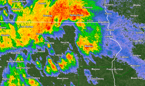
A couple rounds of severe weather struck the region on Saturday, July 23, 2022. The first moved across the local area in the afternoon as storms developed over southern and central Minnesota. Initially storms mostly produced large hail and locally damaging winds. As the storms pushed into southeast MN and northeast IA, they started to coalesce into clusters, eventually evolving into larger bowing segments producing 70 mph winds, broader swaths of wind damage, and at least 3 small tornadoes. Hardest hit was stretch generally just south of I-90, across Houston Co, MN through Vernon Co, WI. These storms exited into central/eastern Wisconsin by 5 pm, allowing for a brief break before the next round of storms developed and moved in. Storms redeveloped by early evening, becoming strong to severe as the evening wore on. Mostly heavy rain and wind gusts to 40 mph were observed, but another swath of damaging winds and at least 1 tornado developed across parts of northeast IA - focused in Winneshiek and Allamakee counties. These storms would push east overnight. Most extensive damage was to areas around Calmar and Waukon, IA. |
 Radar from 10 am to 4 pm, July 23rd 2022 |
Tornadoes:
|
Tornado - Pine Creek (rural county)
|
||||||||||||||||
|
Tornado - Paradise Valley
|
||||||||||||||||
|
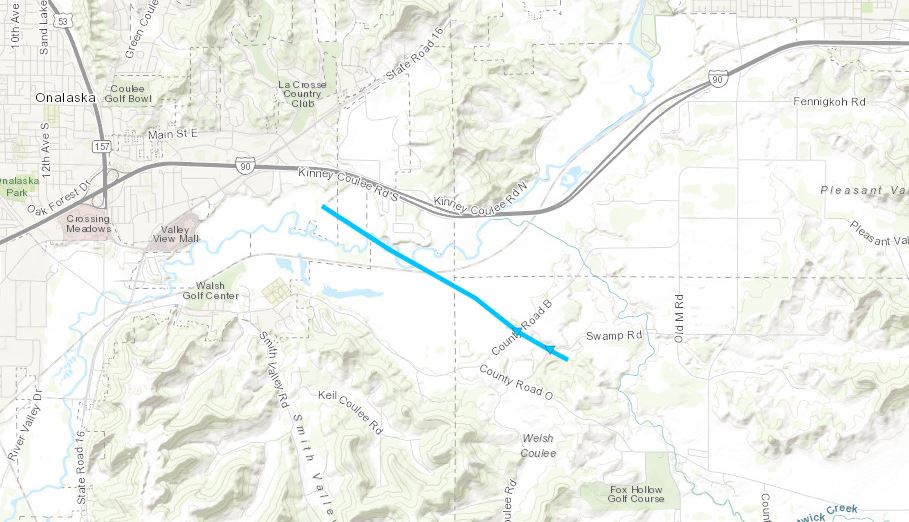
Tornado - Rural La Crosse Co.
|
||||||||||||||||
|
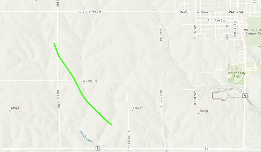
Tornado - West of Waukon
|
||||||||||||||||
The Enhanced Fujita (EF) Scale classifies tornadoes into the following categories:
| EF0 Weak 65-85 mph |
EF1 Moderate 86-110 mph |
EF2 Significant 111-135 mph |
EF3 Severe 136-165 mph |
EF4 Extreme 166-200 mph |
EF5 Catastrophic 200+ mph |
 |
|||||
Peak Wind Reports
PUBLIC INFORMATION STATEMENT
NATIONAL WEATHER SERVICE LA CROSSE WI
515 PM CDT SUN JUL 24 2022

...HIGHEST WIND REPORTS JULY 23RD...

LOCATION                     SPEED     TIME/DATE

STODDARD                     70 MPH    0322 PM 07/23
MAYO HELIPAD                 66 MPH    0135 PM 07/23
3 NE SHELDON                 66 MPH    0305 PM 07/23
4 W WAUKON                   60 MPH    1141 PM 07/23
WAUKON                       60 MPH    1145 PM 07/23
FRENCH ISLAND WI             60 MPH    0330 PM 07/23
3 W NORWALK                  60 MPH    0403 PM 07/23
LA FARGE                     56 MPH    0403 PM 07/23
OELWEIN MUNICIPAL AIRPORT    53 MPH    1155 PM 07/23
ROCHESTER INTERNATIONAL AIRP 52 MPH    0144 PM 07/23
LANCASTER                    51 MPH    0141 AM 07/24
2 N RUSHFORD                 50 MPH    0257 PM 07/23
PATCH GROVE                  50 MPH    1225 AM 07/24
3 NE MOUNT HOPE              50 MPH    1245 AM 07/24
PRESTON AIRPORT              49 MPH    0235 PM 07/23
DECORAH                      48 MPH    1135 PM 07/23
AUSTIN MUNICIPAL AIRPORT     45 MPH    0155 PM 07/23
NODINE MN                    45 MPH    0313 PM 07/23
DODGE CENTER AIRPORT         44 MPH    0135 PM 07/23
LA CROSSE                    43 MPH    0328 PM 07/23
SPARTA/FORT MCCOY AIRPORT    43 MPH    0414 PM 07/23
PLATTEVILLE MUNICIPAL AIRPOR 43 MPH    0115 AM 07/24
ONALASKA                     42 MPH    0337 PM 07/23
NWS LA CROSSE                42 MPH    0338 PM 07/23
CHARLES CITY AIRPORT         40 MPH    1115 PM 07/23
BYRON                        38 MPH    0130 PM 07/23
PLATTEVILLE                  38 MPH    0605 PM 07/23
NEW HAMPTON                  37 MPH    1155 PM 07/23
BOSCOBEL AIRPORT             35 MPH    0115 AM 07/24
NECEDAH                      35 MPH    0148 AM 07/24
HAYFIELD                     34 MPH    0127 PM 07/23
MAUSTON AIRPORT              33 MPH    1235 AM 07/24
ROCHESTER                    32 MPH    0140 PM 07/23
VOLK FIELD                   32 MPH    0439 PM 07/23

OBSERVATIONS ARE COLLECTED FROM A VARIETY OF SOURCES WITH VARYING
EQUIPMENT AND EXPOSURES. WE THANK ALL VOLUNTEER WEATHER OBSERVERS
FOR THEIR DEDICATION. NOT ALL DATA LISTED ARE CONSIDERED OFFICIAL.

$$
Photos:
 |
 |
 |
 |
| North of Houston, MN (Paradise Valley) (NWS La Crosse) |
North of Houston, MN (Paradise Valley) (NWS La Crosse) |
North of Houston, MN (Paradise Valley) (NWS La Crosse) |
North of Houston, MN (Paradise Valley) (NWS La Crosse) |
 |
 |
 |
 |
| House damage in Calmar, IA (NWS La Crosse) |
Tree damage at NICC (NWS La Crosse) |
Lights damaged at football stadium (NWS La Crosse) |
Damage to brand new press box and concession stand at football stadium (NWS La Crosse) |
 |
 |
 |
 |
| Damage at football stadium in Calmar, IA (NWS La Crosse) |
Southern Calmar, IA (NWS La Crosse) |
Damage at softball complex in Calmar, IA (NWS La Crosse) |
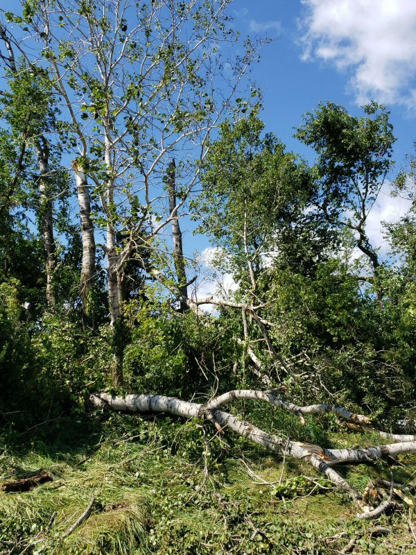
Farm damage west of Waukon, IA (NWS La Crosse) |
 |
 |
 |
 |
| Farm damage west of Waukon, IA (NWS La Crosse) |
Shelf Cloud near Mower/Freeborn Co. line (Photo by Rena Langowski) |
Storm near Rochester, MN (Photo by Andrew Pederson) |
Shelf cloud near Caledonia, MN (Photo by Jim Reed) |
 |
|||
| Tree damage about 6 miles ESE of Viroqua, WI (Photo by Bill Townsley) |
Radar:
|
 |
 |
 |
| Reflectivity from 10 am to 4 pm | Reflectivity from 7 pm to 1 am | Animation of storms across Houston Co., MN | Animation of storms across northeast IA |
Storm Reports
PRELIMINARY LOCAL STORM REPORT...SUMMARY
NATIONAL WEATHER SERVICE LA CROSSE WI
628 PM CDT SUN JUL 24 2022
..TIME... ...EVENT... ...CITY LOCATION... ...LAT.LON...
..DATE... ....MAG.... ..COUNTY LOCATION..ST.. ...SOURCE....
..REMARKS..
1253 PM TSTM WND DMG CLAREMONT 44.04N 93.00W
07/23/2022 DODGE MN LAW ENFORCEMENT
A COUPLE STRUCTURES DAMAGED IN CLAREMONT
AREA.
0111 PM HAIL 5 WNW ORONOCO 44.19N 92.63W
07/23/2022 M1.00 INCH OLMSTED MN STORM CHASER
0115 PM HAIL ORONOCO 44.17N 92.54W
07/23/2022 E1.00 INCH OLMSTED MN PUBLIC
0119 PM TSTM WND GST 3 NNW BYRON 44.07N 92.67W
07/23/2022 E52 MPH OLMSTED MN AMATEUR RADIO
0122 PM TSTM WND GST BYRON 44.04N 92.64W
07/23/2022 E50 MPH OLMSTED MN BROADCAST MEDIA
0123 PM TSTM WND GST DODGE CENTER 44.03N 92.85W
07/23/2022 M48 MPH DODGE MN AWOS
0133 PM TSTM WND DMG ROCHESTER 44.01N 92.48W
07/23/2022 OLMSTED MN BROADCAST MEDIA
NUMEROUS TREES BLOWN DOWN. TIME ESTIMATED.
0134 PM TSTM WND GST 1 NNW ROCHESTER 44.02N 92.48W
07/23/2022 M58 MPH OLMSTED MN AWOS
AT MAYO HELIPORT.
0135 PM TSTM WND GST 1 NW ROCHESTER 44.02N 92.48W
07/23/2022 M66 MPH OLMSTED MN AWOS
ROCHESTER MAYO HELIPAD K9MN REPORTED A WIND
GUST OF 66 MPH.
0137 PM HAIL 1 SW ORONOCO 44.15N 92.54W
07/23/2022 E0.88 INCH OLMSTED MN PUBLIC
0138 PM TSTM WND DMG 2 NNE ROCHESTER 44.04N 92.46W
07/23/2022 OLMSTED MN TRAINED SPOTTER
SEVERAL 8-12 INCH DIAMETER BRANCHES BLOWN
DOWN.
0138 PM HAIL KASSON 44.03N 92.75W
07/23/2022 U0.50 INCH DODGE MN PUBLIC
REPORT FROM MPING: HALF-INCH (0.50 IN.).
0140 PM TSTM WND GST 2 NNE ROCHESTER 44.04N 92.46W
07/23/2022 M62 MPH OLMSTED MN TRAINED SPOTTER
0144 PM TSTM WND GST 3 N BROWNSDALE 43.78N 92.87W
07/23/2022 E66 MPH MOWER MN FIRE DEPT/RESCUE
0149 PM TSTM WND DMG 2 W DODGE CENTER 44.03N 92.90W
07/23/2022 DODGE MN PUBLIC
REPORT FROM MPING: TREES UPROOTED OR
SNAPPED; ROOF BLOWN OFF.
0150 PM TSTM WND DMG AUSTIN 43.67N 92.97W
07/23/2022 MOWER MN BROADCAST MEDIA
REPORTS OF TREES DOWN ON SOUTHWEST AND
NORTHWEST SIDE OF TOWN. TIME ESTIMATED.
0154 PM TSTM WND DMG 1 NW ROCHESTER 44.02N 92.49W
07/23/2022 OLMSTED MN PUBLIC
REPORT FROM MPING: TREES UPROOTED OR
SNAPPED; ROOF BLOWN OFF.
0155 PM TSTM WND DMG 2 SSE ROCHESTER 43.99N 92.46W
07/23/2022 OLMSTED MN PUBLIC
SEVERAL LARGE BRANCHES AND A SIGN BLOWN
DOWN.
0233 PM TSTM WND DMG LANESBORO 43.72N 91.97W
07/23/2022 FILLMORE MN LAW ENFORCEMENT
SEVERAL TREES BLOWN DOWN.
0238 PM TSTM WND GST 4 W PRESTON 43.67N 92.16W
07/23/2022 M49 MPH FILLMORE MN AWOS
REPORTED AT FILLMORE CO. AIRPORT.
0240 PM FLOOD AUSTIN 43.67N 92.97W
07/23/2022 MOWER MN BROADCAST MEDIA
STREET FLOODING REPORTED.
0245 PM TSTM WND DMG 1 NNE SARATOGA 43.90N 92.06W
07/23/2022 WINONA MN PUBLIC
SEVERAL LARGE TREE BRANCHES BLOWN DOWN.
0245 PM TSTM WND DMG RUSHFORD 43.81N 91.75W
07/23/2022 FILLMORE MN LAW ENFORCEMENT
SEVERAL TREES BLOWN DOWN.
0247 PM HEAVY RAIN 3 W ROCHESTER 44.01N 92.54W
07/23/2022 M1.90 INCH OLMSTED MN TRAINED SPOTTER
0253 PM TSTM WND DMG LEWISTON 43.98N 91.87W
07/23/2022 WINONA MN PUBLIC
SEVERAL TREES BLOWN DOWN.
0254 PM TSTM WND GST 3 NNW STEWARTVILLE 43.90N 92.50W
07/23/2022 M51 MPH OLMSTED MN ASOS
ASOS STATION KRST ROCHESTER INTERNATIONAL
AIRPORT.
0257 PM TSTM WND GST 2 N RUSHFORD 43.84N 91.75W
07/23/2022 E50 MPH FILLMORE MN FIRE DEPT/RESCUE
0300 PM TSTM WND DMG 3 W LEWISTON 43.98N 91.93W
07/23/2022 WINONA MN EMERGENCY MNGR
TREES BLOWN DOWN.
0305 PM TSTM WND GST 3 NE SHELDON 43.71N 91.56W
07/23/2022 M66 MPH HOUSTON MN PUBLIC
0306 PM TSTM WND DMG MOUND PRAIRIE 43.78N 91.45W
07/23/2022 HOUSTON MN TRAINED SPOTTER
TREES BLOWN DOWN.
0309 PM HAIL 1 N NODINE 43.92N 91.44W
07/23/2022 M0.25 INCH WINONA MN LAW ENFORCEMENT
0309 PM TSTM WND DMG 1 N NODINE 43.92N 91.44W
07/23/2022 WINONA MN PUBLIC
SEVERAL LARGE BRANCHES BLOWN DOWN.
0313 PM TSTM WND GST NODINE 43.90N 91.45W
07/23/2022 E45 MPH WINONA MN PUBLIC
0320 PM TSTM WND DMG STODDARD 43.66N 91.22W
07/23/2022 VERNON WI EMERGENCY MNGR
TIME ESTIMATED. CAMPERS FLIPPED AND TREES
DOWN BLOCKING RAIL LINE.
0321 PM TSTM WND DMG 2 NE STODDARD 43.68N 91.19W
07/23/2022 VERNON WI PUBLIC
NUMEROUS TREES AND POWERLINES BLOWN DOWN.
FLATTENED CORN FIELDS.
0322 PM TSTM WND GST STODDARD 43.66N 91.22W
07/23/2022 E70 MPH VERNON WI LAW ENFORCEMENT
LOTS OF TREE DAMAGE IN STODDARD AND GENOA
AREAS.
0325 PM TSTM WND DMG LA CROSSE 43.83N 91.23W
07/23/2022 LA CROSSE WI PUBLIC
MULTIPLE LARGE TREES DOWNED THROUGHOUT THE
CITY OF LA CROSSE, SOME CAUSING DAMAGE TO
HOMES AND OTHER STRUCTURES.
0328 PM TSTM WND GST 1 SSW LA CROSSE 43.81N 91.25W
07/23/2022 M43 MPH LA CROSSE WI MESONET
MESONET STATION GW1260 LA CROSSE.
0330 PM TSTM WND GST FRENCH ISLAND 43.86N 91.26W
07/23/2022 E60 MPH LA CROSSE WI TRAINED SPOTTER
0333 PM TSTM WND DMG 3 N STODDARD 43.70N 91.22W
07/23/2022 VERNON WI NWS EMPLOYEE
2 LARGE PINE TREES BLOWN DOWN.
0337 PM TSTM WND GST 2 E ONALASKA 43.89N 91.18W
07/23/2022 M42 MPH LA CROSSE WI MESONET
MESONET STATION GW0323 ONALASKA.
0337 PM FLASH FLOOD 4 S LA CROSSE 43.77N 91.22W
07/23/2022 LA CROSSE WI PUBLIC
REPORT FROM MPING: STREET/ROAD FLOODING;
STREET/ROAD CLOSED; VEHICLES STRANDED.
0339 PM HEAVY RAIN 3 S WINONA 44.00N 91.66W
07/23/2022 M1.43 INCH WINONA MN EMERGENCY MNGR
0341 PM TSTM WND DMG 4 S BARRE MILLS 43.77N 91.13W
07/23/2022 LA CROSSE WI PUBLIC
0341 PM FLASH FLOOD 1 W LA CROSSE 43.83N 91.25W
07/23/2022 LA CROSSE WI PUBLIC
REPORT FROM MPING: STREET/ROAD FLOODING;
STREET/ROAD CLOSED; VEHICLES STRANDED.
0352 PM HEAVY RAIN 5 E BROWNSVILLE 43.73N 91.19W
07/23/2022 M1.62 INCH LA CROSSE WI PUBLIC
0352 PM TSTM WND DMG 6 E VIROQUA 43.56N 90.77W
07/23/2022 VERNON WI LAW ENFORCEMENT
SEVERAL LARGE TREE BLOWN DOWN.
0401 PM TSTM WND DMG ONTARIO 43.73N 90.59W
07/23/2022 VERNON WI PUBLIC
SEVERAL LARGE TREE BLOWN DOWN.
0403 PM TSTM WND GST LA FARGE 43.58N 90.64W
07/23/2022 M56 MPH VERNON WI TRAINED SPOTTER
0403 PM TSTM WND GST 3 W NORWALK 43.83N 90.69W
07/23/2022 E60 MPH MONROE WI TRAINED SPOTTER
0403 PM TSTM WND DMG 4 NE NEW LISBON 43.92N 90.10W
07/23/2022 JUNEAU WI PUBLIC
REPORT FROM MPING: 3-INCH TREE LIMBS BROKEN;
POWER POLES BROKEN.
0415 PM TSTM WND DMG KENDALL 43.79N 90.37W
07/23/2022 MONROE WI PUBLIC
SEVERAL TREES BLOWN DOWN.
0415 PM TSTM WND DMG HILLSBORO 43.65N 90.34W
07/23/2022 VERNON WI LAW ENFORCEMENT
SEVERAL TREES BLOWN DOWN.
0420 PM TSTM WND DMG FOUNTAIN 43.75N 92.13W
07/23/2022 FILLMORE MN PUBLIC
REPORT FROM MPING: 3-INCH TREE LIMBS BROKEN;
POWER POLES BROKEN.
0421 PM HAIL ADAMS 43.96N 89.82W
07/23/2022 M0.70 INCH ADAMS WI TRAINED SPOTTER
0428 PM TSTM WND DMG ONALASKA 43.89N 91.22W
07/23/2022 LA CROSSE WI PUBLIC
SEVERAL LARGE BRANCHES BLOWN DOWN.
0443 PM TSTM WND DMG 2 S LA CROSSE 43.80N 91.23W
07/23/2022 LA CROSSE WI PUBLIC
LARGE TREE SNAPPED DOWN THE MIDDLE.
0449 PM TSTM WND DMG 2 NW HOUSTON 43.79N 91.59W
07/23/2022 HOUSTON MN PUBLIC
REPORT FROM MPING: 3-INCH TREE LIMBS BROKEN;
POWER POLES BROKEN.
0456 PM TSTM WND GST CAMP DOUGLAS 43.92N 90.27W
07/23/2022 M32 MPH JUNEAU WI AWOS
AWOS STATION KVOK VOLK FIELD.
0458 PM TSTM WND GST 4 ENE SPARTA 43.97N 90.73W
07/23/2022 M43 MPH MONROE WI AWOS
AWOS STATION KCMY SPARTA/FORT MCCOY AIRPORT.
0605 PM TSTM WND GST 1 ENE PLATTEVILLE 42.74N 90.46W
07/23/2022 M38 MPH GRANT WI MESONET
MESONET STATION FW1175 PLATTEVILLE.
0935 PM TSTM WND GST 2 ESE DODGE CENTER 44.02N 92.82W
07/23/2022 M31 MPH DODGE MN AWOS
AWOS STATION KTOB DODGE CENTER AIRPORT.
0937 PM TSTM WND GST 3 E AUSTIN 43.67N 92.92W
07/23/2022 M30 MPH MOWER MN AWOS
AWOS STATION KAUM AUSTIN MUNICIPAL AIRPORT.
1014 PM HAIL 2 W SPRING VALLEY 43.69N 92.43W
07/23/2022 E0.75 INCH FILLMORE MN TRAINED SPOTTER
PLUS WIND GUSTS OF 40 MPH.
1115 PM TSTM WND GST 3 E CHARLES CITY 43.07N 92.62W
07/23/2022 M40 MPH FLOYD IA AWOS
AWOS STATION KCCY CHARLES CITY AIRPORT.
1123 PM TSTM WND DMG 5 W WAUZEKA 43.09N 90.98W
07/23/2022 CRAWFORD WI LAW ENFORCEMENT
SEVERAL TREES BLOWN DOWN.
1125 PM TSTM WND DMG 3 E DECORAH 43.30N 91.74W
07/23/2022 WINNESHIEK IA PUBLIC
TREES DOWN IN FREEPORT. TREE COMPLETELY
BLOCKING ROAD NEAR CHURCH/CEMETERY DOWN FROM
WELLINGTON. ANOTHER IN THE ROAD BUT CAN GET
THROUGH ACROSS FROM RECYCLING CENTER.
1125 PM TSTM WND DMG DECORAH 43.30N 91.79W
07/23/2022 WINNESHIEK IA LAW ENFORCEMENT
MANY TREES AND POWERLINES DOWN ACROSS
CENTRAL WINNESHIEK COUNTY FROM NORTH OF
DECORAH TO FORT ATKINSON. TIME ESTIMATED
FROM RADAR.
1127 PM TSTM WND DMG 1 S CALMAR 43.18N 91.87W
07/23/2022 WINNESHIEK IA LAW ENFORCEMENT
REPORT OF A ROOF OFF A HOUSE AND CARS
OVERTURNED NEAR THE NORTHEAST IOWA COMMUNITY
COLLEGE CAMPUS. TIME ESTIMATED FROM RADAR.
1135 PM TSTM WND GST 6 NW FRANKVILLE 43.25N 91.70W
07/23/2022 M48 MPH WINNESHIEK IA MESONET
MESONET STATION RDCI4 DECORAH.
1140 PM TSTM WND GST 4 ENE CONOVER 43.25N 91.82W
07/23/2022 M30 MPH WINNESHIEK IA MESONET
MESONET STATION DVI03565 CALMAR.
1141 PM TSTM WND GST 4 W WAUKON 43.27N 91.56W
07/23/2022 E60 MPH ALLAMAKEE IA LAW ENFORCEMENT
DEPUTY ESTIMATED AT INTERSECTION OF HIGHWAYS
9 AND 51.
1142 PM TSTM WND DMG 2 SW WAUKON 43.25N 91.51W
07/23/2022 ALLAMAKEE IA EMERGENCY MNGR
A FARM LOST A BARN, 2 SILOS, AND 2 POWER
POLES.
1144 PM TSTM WND DMG WAUKON 43.27N 91.48W
07/23/2022 ALLAMAKEE IA LAW ENFORCEMENT
ROOF BLOWN OFF VET CLINIC. PARTIAL ROOF
BLOWN OFF A RESIDENCE. OTHER BUSINESSES IN
DOWNTOWN AREA HAD SOME ROOF DAMAGE. SEVERAL
FLAGPOLES, TREES, AND SIGNS BLOWN DOWN.
1145 PM TSTM WND GST WAUKON 43.27N 91.48W
07/23/2022 E60 MPH ALLAMAKEE IA PUBLIC
SMALL BRANCHES DOWN IN TOWN ALONG WITH SOME
MINOR FLOODING.
1153 PM HAIL 1 E OSSEO 44.57N 91.19W
07/23/2022 U0.50 INCH TREMPEALEAU WI PUBLIC
REPORT FROM MPING: HALF-INCH (0.50 IN.).
1155 PM TSTM WND GST 2 N IONIA 43.07N 92.46W
07/23/2022 M37 MPH CHICKASAW IA MESONET
MESONET STATION RNHI4 NEW HAMPTON.
1155 PM TSTM WND GST 3 W OELWEIN 42.68N 91.97W
07/23/2022 M53 MPH FAYETTE IA AWOS
AWOS STATION KOLZ OELWEIN MUNICIPAL AIRPORT.
1202 AM TSTM WND DMG 4 NE STRAWBERRY POINT 42.72N 91.48W
07/24/2022 CLAYTON IA LAW ENFORCEMENT
REPORTS OF POWER LINES DOWN.
1225 AM TSTM WND GST PATCH GROVE 42.94N 90.97W
07/24/2022 E50 MPH GRANT WI EMERGENCY MNGR
1230 AM TSTM WND DMG GUTTENBERG 42.79N 91.10W
07/24/2022 CLAYTON IA TRAINED SPOTTER
POWERLINE BLOWN DOWN.
1235 AM TSTM WND GST 4 SSE NEW LISBON 43.83N 90.13W
07/24/2022 M33 MPH JUNEAU WI AWOS
AWOS STATION K82C MAUSTON AIRPORT.
1245 AM TSTM WND GST 3 NE MOUNT HOPE 43.00N 90.83W
07/24/2022 E50 MPH GRANT WI TRAINED SPOTTER
LASTED 10 MIN.
0100 AM TSTM WND GST 4 WSW LANCASTER 42.83N 90.79W
07/24/2022 M42 MPH GRANT WI MESONET
MESONET STATION WILCT LANCASTER.
0115 AM TSTM WND GST 4 SSE PLATTEVILLE 42.68N 90.43W
07/24/2022 M43 MPH GRANT WI AWOS
AWOS STATION KPVB PLATTEVILLE MUNICIPAL
AIRPORT.
0141 AM TSTM WND GST 2 SE LANCASTER 42.83N 90.69W
07/24/2022 M51 MPH GRANT WI MESONET
MESONET STATION LKRW3 LANCASTER.
0148 AM TSTM WND GST 1 WNW NECEDAH 44.03N 90.08W
07/24/2022 M35 MPH JUNEAU WI MESONET
MESONET STATION NEHW3 NECEDAH.
0153 AM TSTM WND GST 1 NE BOSCOBEL 43.15N 90.68W
07/24/2022 M35 MPH GRANT WI ASOS
ASOS STATION KOVS BOSCOBEL AIRPORT.
0200 AM FLASH FLOOD 3 ENE GRAND MEADOW 43.72N 92.51W
07/24/2022 MOWER MN LAW ENFORCEMENT
REPORT OF WATER OVER A ROAD. NO OTHER
DETAILS KNOWN.
0800 AM FLOOD SPRING VALLEY 43.69N 92.39W
07/24/2022 FILLMORE MN PUBLIC
SOME STREET FLOODING REPORTED.
0916 AM FLOOD STEWARTVILLE 43.86N 92.49W
07/24/2022 OLMSTED MN PUBLIC
REPORT FROM MPING: RIVER/CREEK OVERFLOWING;
CROPLAND/YARD/BASEMENT FLOODING.
Rain Reports
Public Information Statement
National Weather Service La Crosse WI
1021 AM CDT Sun Jul 24 2022

...PRECIPITATION REPORTS LAST 24 HOURS...

Location                     Amount    Time/Date       Lat/Lon

...Iowa...

...Allamakee County...
Postville 5.5 NE             3.52 in   0700 AM 07/24   43.14N/91.49W
Waukon 0.8 S                 3.44 in   0630 AM 07/24   43.26N/91.47W
Harpers Ferry 6.4 SSW        2.46 in   0700 AM 07/24   43.11N/91.20W
Lansing 4.1 NW               2.17 in   0700 AM 07/24   43.40N/91.29W

...Clayton County...
McGregor 6.4 WNW             2.44 in   0657 AM 07/24   43.07N/91.29W
Monona                       1.74 in   1009 AM 07/24   43.04N/91.39W
Mcgregor                     1.64 in   1005 AM 07/24   43.02N/91.19W
1 WSW Marquette              1.52 in   1000 AM 07/24   43.04N/91.21W

...Howard County...
Lime Springs 1.5 N           3.17 in   0700 AM 07/24   43.47N/92.28W
Saratoga                     2.78 in   1000 AM 07/24   43.35N/92.42W
Riceville                    2.52 in   1000 AM 07/24   43.36N/92.48W

...Mitchell County...

St Ansgar                    2.66 in   0630 AM 07/24   43.38N/92.92W
Osage 4.7 E                  1.84 in   0700 AM 07/24   43.28N/92.72W
STACYVILLE                   1.63 in   1009 AM 07/24   43.44N/92.78W

...Winneshiek County...
Decorah 4.9SE                3.68 in   0600 AM 07/24   43.26N/91.70W
7 ENE Decorah                2.79 in   0838 AM 07/24   43.34N/91.64W
Decorah                      2.32 in   0945 AM 07/24   43.30N/91.80W

...Minnesota...

...Dodge County...
Hayfield 0.3 SSE             3.71 in   0630 AM 07/24   43.89N/92.85W
Hayfield                     3.45 in   1007 AM 07/24   43.89N/92.85W
Claremont 3.1 S              3.32 in   0700 AM 07/24   44.00N/92.99W
Claremont 2.5 ESE            2.48 in   0800 AM 07/24   44.04N/92.95W
Mantorville 1.9 ESE          2.32 in   0700 AM 07/24   44.05N/92.72W

...Fillmore County...
Wykoff 3.1 NW                4.54 in   0700 AM 07/24   43.74N/92.31W
Preston                      4.50 in   0700 AM 07/24   43.67N/92.07W
Spring Valley                4.05 in   0700 AM 07/24   43.69N/92.39W
Preston 3.2 NNE              3.47 in   0800 AM 07/24   43.71N/92.05W
Chatfield 9.0 ESE            3.35 in   0700 AM 07/24   43.79N/92.03W
Chatfield 6.3 ESE            3.23 in   0700 AM 07/24   43.81N/92.08W
Harmony                      2.95 in   0700 AM 07/24   43.56N/92.01W
6 N Spring Valley            2.85 in   0700 AM 07/24   43.78N/92.39W
Chatfield 0.7 SW             2.81 in   0700 AM 07/24   43.84N/92.20W
Mabel                        2.72 in   0715 AM 07/24   43.52N/91.76W
Lanesboro 0.2 SSW            2.16 in   0600 AM 07/24   43.72N/91.97W
Lanesboro                    2.13 in   0930 AM 07/24   43.72N/91.98W
1 NNW Fillmore               1.29 in   0930 AM 07/24   43.76N/92.27W

...Houston County...
Caledonia                    2.12 in   0830 AM 07/24   43.63N/91.50W
Houston 6.9 E                1.97 in   0845 AM 07/24   43.76N/91.43W
La Crescent 5.4 SW           1.96 in   0700 AM 07/24   43.78N/91.39W
La Crescent 0.7 N            1.80 in   0730 AM 07/24   43.84N/91.30W
Brownsville 3.8 SW           1.78 in   0700 AM 07/24   43.65N/91.32W
La Crescent 1.0 WSW          1.53 in   0700 AM 07/24   43.83N/91.32W
Hokah 4 NW                   1.52 in   0700 AM 07/24   43.80N/91.43W
1 ENE Mound Prairie          1.52 in   0700 AM 07/24   43.79N/91.42W
Mound Prairie                0.54 in   0700 AM 07/24   43.78N/91.45W
Mound Prairie                0.51 in   0945 AM 07/24   43.78N/91.45W

...Mower County...
Lansing - Cedar River        5.47 in   0900 AM 07/24   43.75N/92.96W
Ostrander 5.1 WNW            4.31 in   0700 AM 07/24   43.65N/92.52W
Lansing - Cedar River        4.10 in   0930 AM 07/24   43.75N/92.96W
Waltham 2.9 SW               3.74 in   0800 AM 07/24   43.79N/92.91W
Waltham 2.0 SE               3.25 in   0800 AM 07/24   43.80N/92.85W
Austin                       3.13 in   1005 AM 07/24   43.65N/93.00W
Austin 1.5 WSW               3.13 in   0700 AM 07/24   43.67N/93.00W
Austin 2.4 W                 2.77 in   0600 AM 07/24   43.67N/93.02W
Dobbins Creek                2.36 in   0930 AM 07/24   43.68N/92.94W
Austin 3 NW - Turtle Creek   0.63 in   0930 AM 07/24   43.65N/92.98W

...Olmsted County...
2 W High Forest              3.82 in   0700 AM 07/24   43.85N/92.59W
Rochester 2.0 NNE            3.56 in   0700 AM 07/24   44.04N/92.47W
Stewartville 4.3 E           3.45 in   0600 AM 07/24   43.86N/92.40W
Rochester International Airp 3.09 in   0954 AM 07/24   43.90N/92.50W
Rochester 1.6 ENE            2.81 in   0800 AM 07/24   44.03N/92.45W
Rochester 5.6 S              2.74 in   0700 AM 07/24   43.93N/92.47W
Rochester 4.7 ENE            2.57 in   0800 AM 07/24   44.04N/92.39W
1 W Chester                  2.48 in   0645 AM 07/24   44.00N/92.38W
2 NE Rochester               2.31 in   0530 AM 07/24   44.04N/92.44W
Rochester 1.5 WSW            2.30 in   0600 AM 07/24   44.00N/92.50W
Byron                        2.17 in   1000 AM 07/24   44.04N/92.64W
Rochester 5.5 N              2.14 in   0930 AM 07/24   44.10N/92.47W
3 W Rochester                2.10 in   0930 AM 07/24   44.02N/92.53W
Rochester 4.7 N              2.09 in   0700 AM 07/24   44.08N/92.48W
Rochester 3.9 NNW            2.05 in   0800 AM 07/24   44.07N/92.51W
Rochester                    2.02 in   1005 AM 07/24   44.09N/92.49W
Rochester 5.7 N              2.02 in   0800 AM 07/24   44.10N/92.46W
Mayo Helipad                 1.97 in   0955 AM 07/24   44.02N/92.48W
2 NNW Rochester              1.95 in   0600 AM 07/24   44.05N/92.49W
Rochester 5.8 ENE            1.94 in   0700 AM 07/24   44.06N/92.38W
Rochester 2.4 WNW            1.94 in   0800 AM 07/24   44.02N/92.53W
4 NNW Rochester              1.87 in   0700 AM 07/24   44.07N/92.49W
Oronoco 3.3 ESE              1.85 in   0700 AM 07/24   44.14N/92.48W
Rochester                    1.78 in   1005 AM 07/24   44.04N/92.44W
Rochester 4.2 N              1.78 in   0600 AM 07/24   44.08N/92.49W
Rochester                    1.73 in   1005 AM 07/24   44.09N/92.51W
Elgin 2SSW                   1.72 in   0700 AM 07/24   44.10N/92.27W
1 W Oronoco                  1.60 in   0930 AM 07/24   44.17N/92.55W
3 N Rochester                1.35 in   0900 AM 07/24   44.06N/92.47W
3 N Rochester                1.05 in   0915 AM 07/24   44.06N/92.47W
3 ENE Rochester              0.96 in   0930 AM 07/24   44.03N/92.43W
Rochester                    0.89 in   1000 AM 07/24   44.18N/92.41W
Rochester-Beltline Bear Cree 0.89 in   0930 AM 07/24   44.01N/92.45W
5 WSW Rochester              0.66 in   0900 AM 07/24   43.98N/92.56W
Rochester-Cascade Creek      0.57 in   0930 AM 07/24   44.03N/92.47W

...Wabasha County...
Elgin 0.4 WNW                2.10 in   0630 AM 07/24   44.13N/92.26W
Zumbro Falls 3.5 SSW         0.64 in   0730 AM 07/24   44.24N/92.46W
Plainview                    0.52 in   1000 AM 07/24   44.17N/92.17W

...Winona County...
3 SW Elba                    1.67 in   0930 AM 07/24   44.06N/92.05W
Whitewater State Park        1.66 in   0930 AM 07/24   44.05N/92.05W
Lewiston 0.2 NW              1.53 in   0700 AM 07/24   43.99N/91.87W
Lawrence                     1.38 in   1005 AM 07/24   43.88N/91.34W
Beaver                       1.37 in   0700 AM 07/24   44.15N/92.00W
Winona 1.9 ESE               1.37 in   0722 AM 07/24   44.04N/91.63W
1 ESE Winona                 1.31 in   1005 AM 07/24   44.04N/91.63W
3 NE Nodine                  0.81 in   0830 AM 07/24   43.94N/91.41W
Beaver                       0.74 in   0945 AM 07/24   44.15N/92.00W

...Wisconsin...

...Adams County...
Grand Marsh 1.0 W            1.31 in   0700 AM 07/24   43.89N/89.73W
Oxford 4.3 W                 0.98 in   0800 AM 07/24   43.79N/89.65W
0.6 W Friendship             0.92 in   0715 AM 07/24   43.98N/89.83W
Oxford 4.0 W                 0.85 in   0700 AM 07/24   43.79N/89.64W

...Clark County...
Greenwood 0.6 NNW            0.50 in   0700 AM 07/24   44.77N/90.60W

...Crawford County...
Eastman 2.4 NNE              2.54 in   0700 AM 07/24   43.20N/91.00W
2.8 E Harpers Ferry          2.38 in   0915 AM 07/24   43.21N/91.10W
Prairie Du Chien 1.4 N       2.27 in   0700 AM 07/24   43.06N/91.14W
Prairie Du Chien  Airport    2.14 in   0955 AM 07/24   43.02N/91.12W
Steuben 4SE                  2.05 in   0625 AM 07/24   43.13N/90.84W
Steuben                      1.79 in   0945 AM 07/24   43.18N/90.86W
Gays Mills 1.0 NE            1.60 in   0700 AM 07/24   43.33N/90.84W

...Grant County...
Patch Grove 0.1 NNW          1.78 in   0700 AM 07/24   42.94N/90.97W
Muscoda                      1.51 in   1005 AM 07/24   43.19N/90.46W
Boscobel                     1.44 in   1003 AM 07/24   43.15N/90.68W
Muscoda 0.5 WSW              1.42 in   0802 AM 07/24   43.18N/90.44W
Boscobel Airport             1.37 in   1003 AM 07/24   43.15N/90.68W
Platteville                  1.32 in   1005 AM 07/24   42.74N/90.46W
Lancaster                    0.73 in   0941 AM 07/24   42.83N/90.69W

...Jackson County...
Black River Falls 1.7 NNE    1.11 in   0700 AM 07/24   44.32N/90.83W

...Juneau County...
1.0 E Mauston                1.51 in   0800 AM 07/24   43.79N/90.06W
3 ESE Lemonweir              1.32 in   0530 AM 07/24   43.77N/89.96W
Mauston                      1.24 in   1007 AM 07/24   43.80N/90.07W
NECEDAH NWR RY DAM NECEDAH 5 1.12 in   0910 AM 07/24   44.06N/90.17W
Volk Field                   0.99 in   0956 AM 07/24   43.92N/90.27W
New Lisbon                   0.97 in   1000 AM 07/24   43.87N/90.17W
Mauston Airport              0.94 in   0955 AM 07/24   43.83N/90.13W
New Lisbon 5.2 ENE           0.91 in   0700 AM 07/24   43.91N/90.07W
Mauston 7.6 NE               0.81 in   0700 AM 07/24   43.88N/89.98W
Necedah                      0.55 in   0948 AM 07/24   44.03N/90.08W

...La Crosse County...
La Crosse 2.4 S              1.83 in   0800 AM 07/24   43.79N/91.23W
La Crosse                    1.62 in   0208 AM 07/24   43.82N/91.19W
Coon Valley 4.5 NNW          1.54 in   0700 AM 07/24   43.76N/91.06W
Burns                        1.43 in   1008 AM 07/24   43.91N/90.97W
La Crosse                    1.31 in   1008 AM 07/24   43.81N/91.25W
Onalaska                     1.21 in   1007 AM 07/24   43.89N/91.18W
Onalaska 1.9 E               1.21 in   0700 AM 07/24   43.89N/91.18W
Onalaska 2N                  1.14 in   0700 AM 07/24   43.91N/91.23W
West Salem 0.7 W             1.11 in   0700 AM 07/24   43.90N/91.10W
West Salem                   1.11 in   0700 AM 07/24   43.90N/91.09W
Onalaska 0.6 SW              1.08 in   0800 AM 07/24   43.88N/91.23W
La Crosse Regional Airport   1.05 in   0953 AM 07/24   43.88N/91.25W
Holmen 2 S                   1.00 in   0700 AM 07/24   43.93N/91.25W
Holmen 1.7 SSE               1.00 in   0700 AM 07/24   43.93N/91.24W
La Crosse 4NNW               0.92 in   0730 AM 07/24   43.87N/91.27W

...Monroe County...
Wilton 4.2 E                 1.63 in   0700 AM 07/24   43.81N/90.44W
0.5 SW Sparta                1.47 in   0800 AM 07/24   43.94N/90.82W
Sparta/Fort McCoy Airport    1.07 in   0958 AM 07/24   43.97N/90.73W
Tomah 7.5 SSW                0.96 in   0700 AM 07/24   43.90N/90.58W

...Richland County...
Cazenovia 4.4 SSW            3.54 in   0700 AM 07/24   43.47N/90.23W
Richland Center 4 N          1.72 in   0700 AM 07/24   43.40N/90.39W
Richland Center 4.0 N        1.72 in   0800 AM 07/24   43.40N/90.39W
1 SSE Richland Center        1.31 in   1009 AM 07/24   43.32N/90.38W

...Taylor County...
Medford 0.8 ENE              0.57 in   0700 AM 07/24   45.14N/90.33W
Medford                      0.51 in   1000 AM 07/24   45.30N/90.30W

...Trempealeau County...
1 NW Trempealeau             1.09 in   0700 AM 07/24   44.03N/91.46W
Trempealeau                  0.72 in   1006 AM 07/24   44.07N/91.51W
Ettrick 4.0 WNW              0.52 in   0713 AM 07/24   44.19N/91.34W
Trempealeau 7.6 NNW          0.51 in   0700 AM 07/24   44.11N/91.48W

...Vernon County...
0.5 E Viroqua                2.69 in   0700 AM 07/24   43.56N/90.88W
Viroqua 0.8 ESE              2.54 in   0700 AM 07/24   43.55N/90.87W
La Farge                     2.17 in   1000 AM 07/24   43.60N/90.63W
Hillsboro 2 SW               1.87 in   0700 AM 07/24   43.63N/90.38W
Viroqua Municipal Airport    1.63 in   1015 AM 07/24   43.58N/90.90W
Stoddard 1.5 NE              1.43 in   0730 AM 07/24   43.67N/91.19W
Hillsboro 0.5 WSW            1.35 in   0700 AM 07/24   43.65N/90.35W
Genoa                        1.13 in   1006 AM 07/24   43.56N/91.22W
Ontario                      1.01 in   0945 AM 07/24   43.72N/90.59W

Observations are collected from a variety of sources with varying
equipment and exposures. We thank all volunteer weather observers
for their dedication. Not all data listed are considered official.

$$
Additional Information
Storm Prediction Center Outlooks
 |
 |
 |
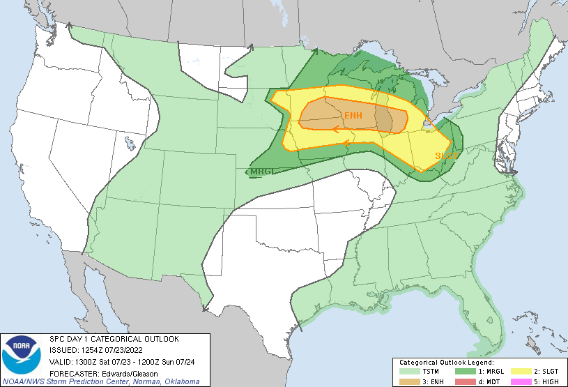 |
| SPC Day 4 Outlook | SPC Day 3 Outlook | SPC Day 2 Outlook | SPC Day 1 Outlook |
Watches / NWS La Crosse Graphics
 |
 |
 |
 |
| First Severe Thunderstorm Watch of the day | Second Severe Thunderstorm Watch | NWS La Crosse Weather Story Graphic | Timing graphic for approaching storms |
 |
Media use of NWS Web News Stories is encouraged! Please acknowledge the NWS as the source of any news information accessed from this site. |
|