Overview
|
Numerous rounds of thunderstorms moved through the region on Wednesday July 14 2010 with an endless supply of very humid and hot air. During the day, temperatures warmed to near 90 degrees and the dewpoint reached 75-80F. Dewpoint is the direct measure of the amount of water in the air (as a gas) - and at 70F - most people feel it is "very humid outside". The heat index, a direct measure of how both dewpoint and temperature impact the body and how you would truly feel the heat, was near 110F at mid-afternoon. The first batch of storms came through in the early afternoon over northern and central Wisconsin as a squall line moved in and brought wind damage between 12pm and 2 pm. A second line of storms then formed from near Eau Claire Wisconsin into southeast Minnesota. This second phase brought more of a tornado threat and many reports of large hail, damaging winds to 75 mph, and tornadoes occurred between 3pm and 8pm. With the air still unbelievably warm and humid at 8 pm, a cold front moving through Minnesota ignited a third and final round of severe storms. This line developed over southeast Minnesota and built northeast into north central Wisconsin bringing more damaging wind reports and flash flooding. The line did fill in further south bringing some weather to Northeast Iowa and southwest Wisconsin - but they were largely spared from much of the severe weather. These repeated rounds of rain finally took their toll and northern Monroe and southern Jackson County reported flash flooding with road closures and many roads underwater in the late evening on July 14. Street flooding also occurred in the cities of La Crosse and Winona. The NWS issued 27 warnings beginning at noon and ending around 1 am. 72% of the Severe Thunderstorm Warnings were verified with an average of 25 minutes until the first report was received in the warning (e.g., lead time). 20% of those 27 warnings were considered false alarms and did not have reports of severe weather within them. |
 Radar reflectivity and storm-relative velocity loop of the Osseo-Northfield-Humbird-Sherwood storm from 4:00-5:15 p.m. |
Tornadoes:
|
Tornado - Lake Arbutus, WI
Track Map   |
||||||||||||||||
The Enhanced Fujita (EF) Scale classifies tornadoes into the following categories:
| EF0 Weak 65-85 mph |
EF1 Moderate 86-110 mph |
EF2 Significant 111-135 mph |
EF3 Severe 136-165 mph |
EF4 Extreme 166-200 mph |
EF5 Catastrophic 200+ mph |
 |
|||||
Photos:
 |
 |
 |
 |
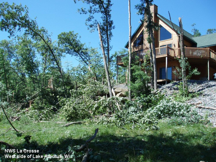
| Damage in the Lake Arbutus area. (NWS Survey) |
Damage in the Lake Arbutus area. (NWS Survey) |
Damage in the Lake Arbutus area. (NWS Survey) |
Damage in the Lake Arbutus area. (NWS Survey) |
 |
 |
||
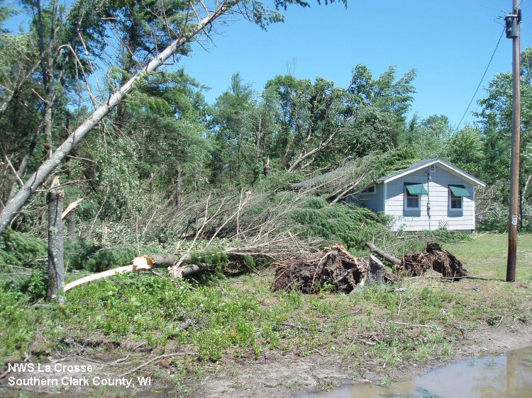
| Damage in the Lake Arbutus area. (NWS Survey) |
Damage in the Lake Arbutus area. (NWS Survey) |
Radar & Maps:
 |
 |
 |
 |
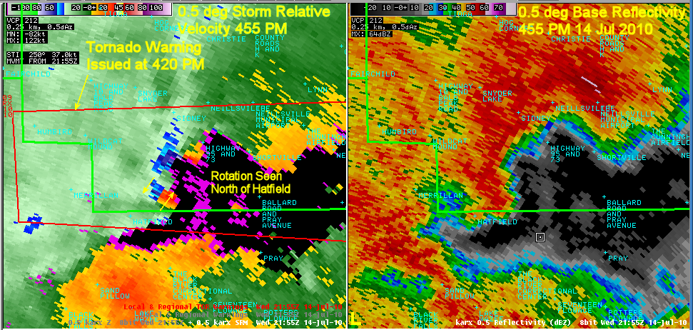
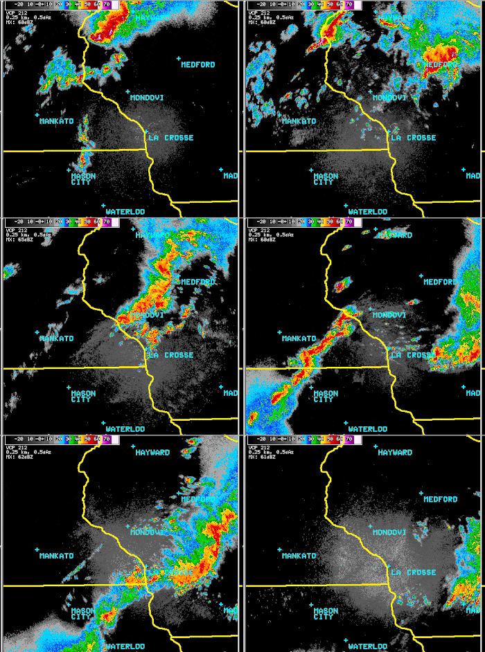
| Radar image of reflectivity and rotation at 4:55 p.m. near Lake Arbutus, WI | Regional radar loop from 11 a.m. to around Midnight. Images every 30 minutes. | Zoomed-in, local radar loop from 11 a.m. to around Midnight. Images every 30 minutes. | Rainfall totals estimated by the radar for July 14. Values of less than 1" were removed. |
 |
 |
||
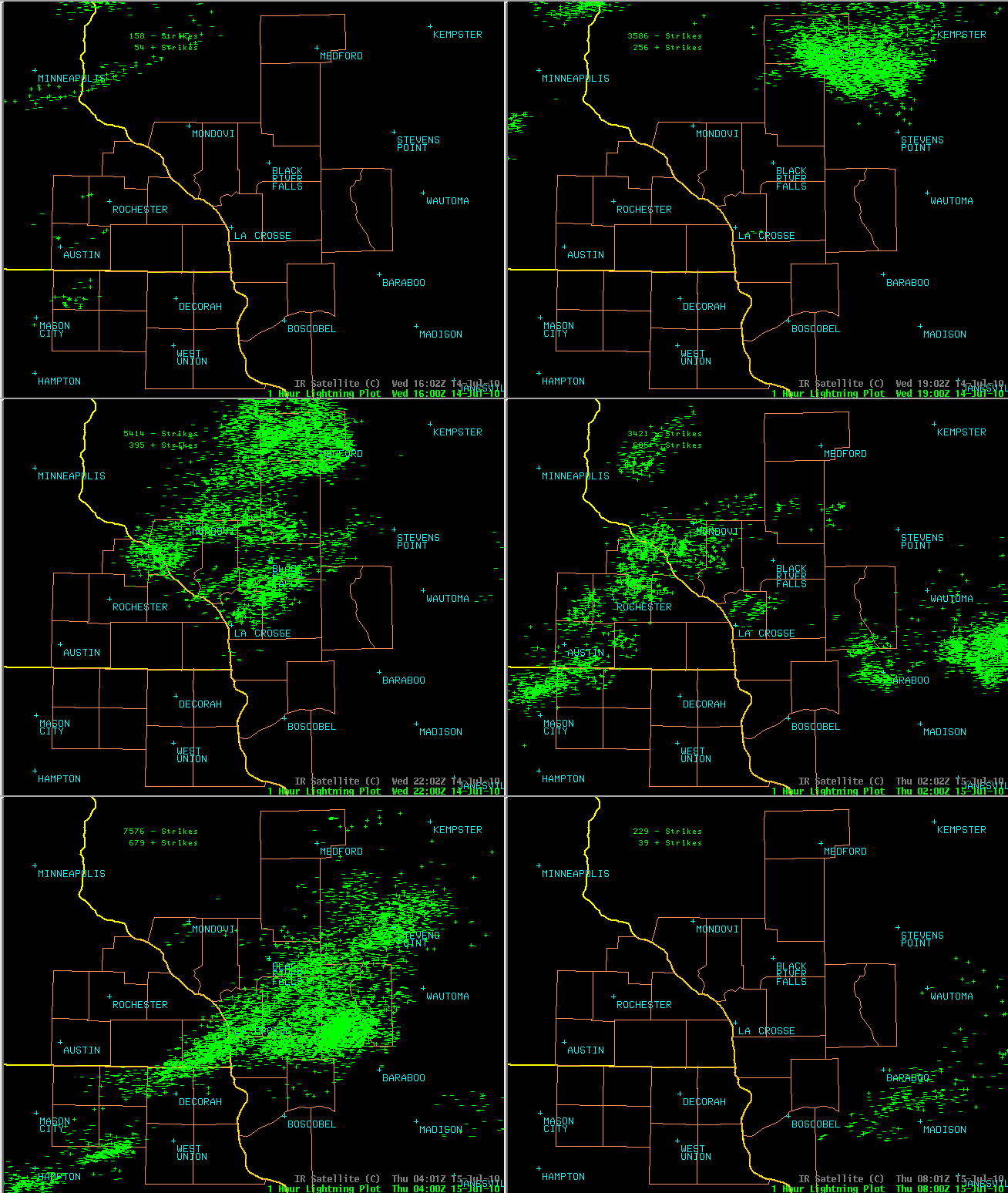
| Lightning loop from 11 a.m. to around Midnight. Each cloud-to-ground lightning strike is plotted, image shows an hourly total. Some strike totals were nearly 9000 per hour over the area shown! | Observed 24-hour rainfall totals through July 15 7 a.m. |
Storm Reports
PRELIMINARY LOCAL STORM REPORT...SUMMARY
NATIONAL WEATHER SERVICE LA CROSSE WI
1045 AM CDT THU JUL 15 2010

..TIME...   ...EVENT...      ...CITY LOCATION...     ...LAT.LON...
..DATE...   ....MAG....      ..COUNTY LOCATION..ST.. ...SOURCE....
            ..REMARKS..

1226 PM     TSTM WND DMG     7 WSW LUBLIN            45.04N 90.86W
07/14/2010                   TAYLOR             WI   PUBLIC

            LARGE BRANCHES AND POWER LINES DOWN. NEAR VERY SOUTHWEST
            CORNER OF COUNTY.

1229 PM     TSTM WND DMG     3 SSW LUBLIN            45.04N 90.75W
07/14/2010                   TAYLOR             WI   PUBLIC

            SEVERAL TREES BLOWN DOWN

0106 PM     TSTM WND DMG     OWEN                    44.95N 90.57W
07/14/2010                   CLARK              WI   FIRE DEPT/RESCUE

            TREES DOWN IN OWEN

0110 PM     TSTM WND DMG     3 E LOYAL               44.74N 90.44W
07/14/2010                   CLARK              WI   AMATEUR RADIO

            TREE DOWN ON HIGHWAY 98. TIME ESTIMATED.

0114 PM     TSTM WND DMG     ABBOTSFORD              44.95N 90.32W
07/14/2010                   CLARK              WI   AMATEUR RADIO

            TREE DOWN WITH POWER OUTAGE

0117 PM     TSTM WND DMG     5 NNE LOYAL             44.80N 90.46W
07/14/2010                   CLARK              WI   TRAINED SPOTTER

            TREES DOWN. ESTIMATED 60 MPH GUST.

0120 PM     TSTM WND GST     6 E LOYAL               44.74N 90.37W
07/14/2010  E60.00 MPH       CLARK              WI   PUBLIC

            REPORTED FROM 2 MILES SOUTHWEST OF SPENCER WI

0322 PM     TSTM WND GST     LAKE CITY               44.45N 92.28W
07/14/2010  E60.00 MPH       WABASHA            MN   CO-OP OBSERVER

0338 PM     TSTM WND GST     LAKE CITY               44.45N 92.28W
07/14/2010  M65.00 MPH       WABASHA            MN   FIRE DEPT/RESCUE

0400 PM     TSTM WND GST     OSSEO                   44.58N 91.22W
07/14/2010  E75.00 MPH       TREMPEALEAU        WI   FIRE DEPT/RESCUE

0400 PM     HAIL             2 E OSSEO               44.58N 91.18W
07/14/2010  E2.00 INCH       TREMPEALEAU        WI   TRAINED SPOTTER

            TRAINED SPOTTER ESTIMATES 1 TO 2 INCH SIZE HAIL

0400 PM     HAIL             OSSEO                   44.58N 91.22W
07/14/2010  E1.00 INCH       TREMPEALEAU        WI   FIRE DEPT/RESCUE

0400 PM     HAIL             OSSEO                   44.58N 91.22W
07/14/2010  E1.25 INCH       TREMPEALEAU        WI   PUBLIC

0412 PM     FUNNEL CLOUD     4 E OSSEO               44.58N 91.14W
07/14/2010                   JACKSON            WI   TRAINED SPOTTER

            ROTATING WALL CLOUD WITH POSSIBLE FUNNEL

0415 PM     TORNADO          5 SE OSSEO              44.53N 91.15W
07/14/2010                   JACKSON            WI   TRAINED SPOTTER

            TRAINED SPOTTERS REPORT TORNADO ON SOUTHEASTERN SIDE OF
            OSSEO

0419 PM     TORNADO          6 ESE OSSEO             44.54N 91.11W
07/14/2010                   JACKSON            WI   LAW ENFORCEMENT

            LAW ENFORCEMENT REPORTS TORNADO ON GROUND 6 MILES ESE OF
            OSSEO

0420 PM     TSTM WND DMG     8 WNW ARCADIA           44.30N 91.64W
07/14/2010                   BUFFALO            WI   LAW ENFORCEMENT

            TREES DOWN - BUILDINGS DAMAGED

0420 PM     TORNADO          4 SE OSSEO              44.54N 91.16W
07/14/2010                   JACKSON            WI   LAW ENFORCEMENT

            JACKSON COUNTY SHERIFF REPORTS TORNADO CROSSING I-94 AT
            MILE MARKER 96

0424 PM     TORNADO          LUBLIN                  45.08N 90.72W
07/14/2010                   TAYLOR             WI   LAW ENFORCEMENT

            UNCONFIRMED TORNADO IN ROOSEVELT TOWNSHIP
0425 PM     TORNADO          4 NW ALMA CENTER        44.48N 90.97W
07/14/2010                   JACKSON            WI   NWS STORM SURVEY

            FIRST EVIDENCE OF TREE DAMAGE WAS NOTED ALONG TOWN HOUSE
            ROAD. DAMAGE INTERMITTENTLY CONTINUED EAST SOUTHEAST
            THROUGH THE VILLAGE OF MERRILLAN. ALL THIS DAMAGE WAS
            EF0. THE TORNADO INCREASED IN INTENSITY AS IT CROSSED
            INTO SOUTHERN CLARK COUNTY NEAR BRUCE MOUND...CROSSED THE
            NORTH SIDE OF LAKE ARBUTUS...NEAR BUSH ROAD PRODUCING
            EXTENSIVE TREE DAMAGE...EF1. THE TORNADO ENDED NEAR
            COUNTY Z NEAR SHERWOOD LAKE AROUND 513 PM. PATH LENGTH 31
            MILES. MAX WIDTH 150 YARDS.
0428 PM     TSTM WND DMG     GILMAN                  45.17N 90.81W
07/14/2010                   TAYLOR             WI   AMATEUR RADIO

            POWER OUTAGE WITH HIGH WINDS REPORTED.

0434 PM     FUNNEL CLOUD     2 E ROCKLAND            43.91N 90.88W
07/14/2010                   MONROE             WI   PUBLIC

            MULTIPLE DRIVERS REPORT FUNNEL ALONG I-90 NEAR MILE
            MARKER 20.

0440 PM     TSTM WND DMG     3 E LEVIS               44.54N 91.04W
07/14/2010                   JACKSON            WI   LAW ENFORCEMENT

            NUMEROUS TREES AND POWER LINES DOWN ACROSS NORTHERN
            JACKSON COUNTY

0445 PM     TSTM WND GST     5 W COLBY               44.91N 90.42W
07/14/2010  E50.00 MPH       CLARK              WI   AMATEUR RADIO

0446 PM     TSTM WND DMG     HUMBIRD                 44.53N 90.90W
07/14/2010                   CLARK              WI   PUBLIC

            SEVERAL TREES DOWN. WINDS ESTIMATED AT 60-70 MPH.

0450 PM     TSTM WND DMG     BRUCE MOUND             44.45N 90.78W
07/14/2010                   CLARK              WI   AMATEUR RADIO

            TREES DOWN AT COUNTY ROAD J AND HWY 95

0450 PM     TSTM WND DMG     BRUCE MOUND             44.45N 90.78W
07/14/2010                   CLARK              WI   AMATEUR RADIO

            TREES DOWN AT HIGHWAY 95

0500 PM     FUNNEL CLOUD     1 NW SPARTA             43.95N 90.82W
07/14/2010                   MONROE             WI   AMATEUR RADIO

            FUNNEL CLOUD NEAR WALMART IN NORTHWEST SPARTA

0522 PM     TSTM WND DMG     3 NE WILTON             43.85N 90.48W
07/14/2010                   MONROE             WI   TRAINED SPOTTER

            15 INCH DIAMETER TREE DOWN ON HWY 131

0525 PM     TSTM WND GST     5 W TOMAH               43.99N 90.60W
07/14/2010  E60.00 MPH       MONROE             WI   AMATEUR RADIO

0529 PM     TORNADO          FORT MC COY             44.02N 90.68W
07/14/2010                   MONROE             WI   AMATEUR RADIO

            TORNADO REPORTED ON THE GROUND WEST SIDE OF BASE

0543 PM     NON-TSTM WND DMG 6 N BIG FLATS           44.21N 89.80W
07/14/2010                   ADAMS              WI   LAW ENFORCEMENT

            TREES AND POWER LINES DOWN

0617 PM     HAIL             2 N CAMP DOUGLAS        43.95N 90.27W
07/14/2010  E0.75 INCH       JUNEAU             WI   LAW ENFORCEMENT

            WINDS 30 MPH

0620 PM     NON-TSTM WND GST SPARTA                  43.94N 90.81W
07/14/2010  E50.00 MPH       MONROE             WI   AMATEUR RADIO

0648 PM     HEAVY RAIN       2 SSE NECEDAH           44.00N 90.06W
07/14/2010  M2.40 INCH       JUNEAU             WI   AMATEUR RADIO

0653 PM     HEAVY RAIN       BIG FLATS               44.12N 89.80W
07/14/2010  E2.60 INCH       ADAMS              WI   CO-OP OBSERVER

0655 PM     HEAVY RAIN       WARRENS                 44.13N 90.50W
07/14/2010  M3.25 INCH       MONROE             WI   AMATEUR RADIO

0704 PM     HAIL             5 WSW TOMAH             43.96N 90.60W
07/14/2010  E0.25 INCH       MONROE             WI   AMATEUR RADIO

            PONDING OF WATER AND WINDS 35 MPH WITH SMALL HAIL AT
            JACKSON PASS

0713 PM     HEAVY RAIN       LEON                    43.88N 90.83W
07/14/2010  M1.30 INCH       MONROE             WI   TRAINED SPOTTER

0725 PM     HEAVY RAIN       KENDALL                 43.79N 90.37W
07/14/2010  E1.08 INCH       MONROE             WI   TRAINED SPOTTER

0757 PM     FUNNEL CLOUD     2 NE ORONOCO            44.18N 92.51W
07/14/2010                   OLMSTED            MN   TRAINED SPOTTER

0812 PM     TSTM WND GST     AUSTIN                  43.67N 92.97W
07/14/2010  E60.00 MPH       MOWER              MN   BROADCAST MEDIA

            AT KAAL STUDIOS

0815 PM     TSTM WND GST     AUSTIN                  43.67N 92.97W
07/14/2010  M59.00 MPH       MOWER              MN   ASOS

0833 PM     TSTM WND GST     STEWARTVILLE            43.86N 92.49W
07/14/2010  M50.00 MPH       OLMSTED            MN   ASOS

0835 PM     TSTM WND GST     5 S ROCHESTER           43.94N 92.48W
07/14/2010  M60.00 MPH       OLMSTED            MN   CO-OP OBSERVER

            COOPERATIVE OBSERVER MEASURED 50-60 MPH AND TREE BRANCHES
            SNAPPING

0835 PM     TSTM WND DMG     5 E BUFFALO             44.22N 91.77W
07/14/2010                   BUFFALO            WI   LAW ENFORCEMENT

            MULTIPLE TREES DOWN

0835 PM     TSTM WND GST     ROCK DELL               43.91N 92.65W
07/14/2010  E55.00 MPH       OLMSTED            MN   AMATEUR RADIO

0841 PM     TSTM WND GST     BYRON                   44.03N 92.65W
07/14/2010  E50.00 MPH       OLMSTED            MN   AMATEUR RADIO

0844 PM     HEAVY RAIN       NELSON                  44.42N 92.00W
07/14/2010  M3.00 INCH       BUFFALO            WI   FIRE DEPT/RESCUE

            STANDING WATER IN DITCHES

0845 PM     TSTM WND DMG     2 SE WAUMANDEE          44.28N 91.67W
07/14/2010                   BUFFALO            WI   LAW ENFORCEMENT

            CHICKEN BARN DAMAGED IN THE ALLIGATOR SLIDE AREA

0845 PM     TSTM WND DMG     COCHRANE                44.23N 91.84W
07/14/2010                   BUFFALO            WI   LAW ENFORCEMENT

            TREES DOWN

0852 PM     TSTM WND GST     2 W ARCADIA             44.25N 91.53W
07/14/2010  E60.00 MPH       TREMPEALEAU        WI   LAW ENFORCEMENT

            ALONG WITH VERY HEAVY RAIN

0859 PM     TSTM WND GST     1 SW LE ROY             43.50N 92.52W
07/14/2010  E52.00 MPH       MOWER              MN   TRAINED SPOTTER

0921 PM     TSTM WND DMG     1 W WINONA              44.05N 91.68W
07/14/2010                   WINONA             MN   EMERGENCY MNGR

            TREES DOWN WEST SIDE OF WINONA

0921 PM     TSTM WND GST     4 SW WINONA             44.01N 91.71W
07/14/2010  M48.00 MPH       WINONA             MN   TRAINED SPOTTER

0925 PM     TSTM WND GST     HARMONY                 43.56N 92.01W
07/14/2010  E40.00 MPH       FILLMORE           MN   AMATEUR RADIO

0943 PM     TSTM WND GST     LA CROSSE               43.83N 91.23W
07/14/2010  M60.00 MPH       LA CROSSE          WI   ASOS

            AT LA CROSSE AIRPORT

0944 PM     TSTM WND GST     2 W HOKAH               43.76N 91.39W
07/14/2010  M55.00 MPH       HOUSTON            MN   AMATEUR RADIO

0945 PM     TSTM WND DMG     1 N LA CRESCENT         43.84N 91.30W
07/14/2010                   HOUSTON            MN   PUBLIC

            TWO TREES UPROOTED AND 18 INCH BRANCH BROKEN OFF TREE

0945 PM     TSTM WND GST     LA CRESCENT             43.83N 91.30W
07/14/2010  E60.00 MPH       HOUSTON            MN   TRAINED SPOTTER

0948 PM     TSTM WND DMG     LA CROSSE               43.83N 91.23W
07/14/2010                   LA CROSSE          WI   AMATEUR RADIO

            TREES DOWN IN LA CROSSE

0948 PM     TSTM WND GST     3 S LA CROSSE           43.78N 91.23W
07/14/2010  M57.00 MPH       LA CROSSE          WI   AMATEUR RADIO

0952 PM     TSTM WND GST     2 W ST JOSEPH           43.79N 91.07W
07/14/2010  E50.00 MPH       LA CROSSE          WI   TRAINED SPOTTER

0954 PM     FLOOD            ARCADIA                 44.25N 91.49W
07/14/2010                   TREMPEALEAU        WI   LAW ENFORCEMENT

            SOME STREET FLOODING CLOSING SOME STREETS. A TOTAL OF 3.5
            INCHES OF RAIN SO FAR TODAY.

1003 PM     FLASH FLOOD      3 N CATARACT            44.13N 90.83W
07/14/2010                   MONROE             WI   LAW ENFORCEMENT

            WATER OVER COUNTY ROAD SS

1005 PM     TSTM WND DMG     2 SE COON VALLEY        43.68N 90.98W
07/14/2010                   VERNON             WI   LAW ENFORCEMENT

            TREE DOWN NEAR KOLL ROAD

1006 PM     TSTM WND GST     TOMAH                   43.99N 90.50W
07/14/2010  E55.00 MPH       MONROE             WI   TRAINED SPOTTER

            VERY HEAVY RAIN AND STREET FLOODING

1010 PM     TSTM WND DMG     4 NW VIROQUA            43.60N 90.94W
07/14/2010                   VERNON             WI   LAW ENFORCEMENT

            MULTIPLE TREES DOWN

1010 PM     TSTM WND GST     CASHTON                 43.74N 90.78W
07/14/2010  E45.00 MPH       MONROE             WI   TRAINED SPOTTER

1012 PM     TSTM WND GST     1 W WESTBY              43.65N 90.88W
07/14/2010  E50.00 MPH       VERNON             WI   AMATEUR RADIO

1017 PM     TSTM WND GST     VOLK FIELD              43.93N 90.27W
07/14/2010  M57.00 MPH       JUNEAU             WI   AWOS

1017 PM     FLASH FLOOD      1 W WARRENS             44.13N 90.52W
07/14/2010                   MONROE             WI   TRAINED SPOTTER

            DEEP WATER THROUGH MUCH OF JELLYSTONE CAMPGROUND

1017 PM     FLASH FLOOD      4 N CATARACT            44.14N 90.83W
07/14/2010                   MONROE             WI   TRAINED SPOTTER

            WATER OVER HIGHWAY 27 AND ALPHA AVE

1017 PM     HEAVY RAIN       TOMAH                   43.99N 90.50W
07/14/2010  M6.50 INCH       MONROE             WI   AMATEUR RADIO

1026 PM     TSTM WND GST     1 W WESTBY              43.65N 90.88W
07/14/2010  M55.00 MPH       VERNON             WI   AMATEUR RADIO

1030 PM     FLASH FLOOD      2 W WARRENS             44.13N 90.54W
07/14/2010                   MONROE             WI   TRAINED SPOTTER

            ROAD DAMAGED NEAR HIGHWAY 12 AND COUNTY ROAD EW.

1030 PM     TSTM WND GST     ONTARIO                 43.72N 90.59W
07/14/2010  E50.00 MPH       VERNON             WI   LAW ENFORCEMENT

1035 PM     TSTM WND GST     5 SW ADAMS              43.90N 89.89W
07/14/2010  E60.00 MPH       ADAMS              WI   PARK/FOREST SRVC

            REPORTED AT CASTLE ROCK COUNTY PARK CAMPRGROUND

1040 PM     TSTM WND GST     6 S ADAMS               43.87N 89.82W
07/14/2010  M64.00 MPH       ADAMS              WI   AMATEUR RADIO

1124 PM     TSTM WND DMG     VIROQUA                 43.56N 90.89W
07/14/2010                   VERNON             WI   LAW ENFORCEMENT

            DAMAGE TO SHED AT SHERIFF DEPARTMENT. TREES DOWN IN TOWN
            AS WELL.

1126 PM     TSTM WND GST     1 S WESTBY              43.64N 90.86W
07/14/2010  E60.00 MPH       VERNON             WI   AMATEUR RADIO

1135 PM     TSTM WND DMG     4 W VIROQUA             43.56N 90.97W
07/14/2010                   VERNON             WI   LAW ENFORCEMENT

            TREE DOWN AT HWY 56 AND XX

1140 PM     TSTM WND DMG     5 W HILLSBORO           43.65N 90.44W
07/14/2010                   VERNON             WI   LAW ENFORCEMENT

            TREES BLOWN DOWN FROM VIROQUA TO NEAR HILLSBORO

1140 PM     TSTM WND DMG     6 NE VIROQUA            43.62N 90.80W
07/14/2010                   VERNON             WI   LAW ENFORCEMENT

            TREE DOWN NEAR AVALANCHE

1153 PM     TSTM WND DMG     PLEASANT RIDGE          43.69N 90.21W
07/14/2010                   JUNEAU             WI   LAW ENFORCEMENT

            TREES AND POWER LINES DOWN ACROSS MUCH OF THE SOUTHERN
            PART OF THE COUNTY.

1153 PM     NON-TSTM WND DMG 5 WNW DAVIS CORNERS     43.39N 92.39W
07/14/2010                   HOWARD             IA   LAW ENFORCEMENT

            WIDESPREAD TREES AND POWER LINES DOWN

1201 AM     HEAVY RAIN       4 SW WARRENS            44.09N 90.56W
07/15/2010  M7.00 INCH       MONROE             WI   TRAINED SPOTTER

            FOR ALL OF JULY 14TH

1209 AM     HEAVY RAIN       CATARACT                44.09N 90.83W
07/15/2010  M4.62 INCH       MONROE             WI   CO-OP OBSERVER

1249 AM     HEAVY RAIN       3 SE NECEDAH            43.99N 90.03W
07/15/2010  M3.22 INCH       JUNEAU             WI   CO-OP OBSERVER

1254 AM     HEAVY RAIN       VALLEY                  43.65N 90.53W
07/15/2010  E3.95 INCH       VERNON             WI   CO-OP OBSERVER

0124 AM     FLOOD            1 E ROCKTON             43.65N 90.58W
07/15/2010                   VERNON             WI   CO-OP OBSERVER

            RUNNING WATER 2 TO 3 INCHES DEEP OVER COUNTY P JUST EAST
            OF ROCKTON.
Rain Reports
PUBLIC INFORMATION STATEMENT
NATIONAL WEATHER SERVICE LA CROSSE WI
750 AM CDT THU JUL 15 2010

...24 HOUR RAINFALL TOTALS ACROSS THE AREA...
LOCATION                   RAINFALL    TIME     LAT/LON


IOWA

...ALLAMAKEE COUNTY...
POSTVILLE                  0.22        0700 AM  43.09N 91.56W
DORCHESTER HIGHWAY 76      0.16        0700 AM  43.42N 91.51W
ION                        0.12        0700 AM  43.11N 91.27W
WAUKON                     0.11        0700 AM  43.27N 91.47W
LANSING 4SE                0.07        0700 AM  43.32N 91.16W
HARPERS FERRY              0.02        0700 AM  43.17N 91.24W

...CHICKASAW COUNTY...
NEW HAMPTON                0.15        0700 AM  43.06N 92.31W
IONIA                      0.09        0700 AM  43.03N 92.50W

...CLAYTON COUNTY...
ELKADER                    0.22        0700 AM  42.84N 91.40W
MCGREGOR                   0.17        0700 AM  43.02N 91.17W
VOLGA                      0.07        0700 AM  42.81N 91.52W
MARQUETTE                  0.04        0700 AM  43.04N 91.21W
STRAWBERRY POINT           0.00        0700 AM  42.69N 91.53W

...FAYETTE COUNTY...
ELDORADO                   0.20        0700 AM  43.05N 91.81W

...FLOYD COUNTY...
CHARLES CITY COOP          0.23        0700 AM  43.08N 92.67W
CHARLES CITY CEDAR RVR     0.18        0700 AM  43.06N 92.67W
CHARLES CITY AWOS          0.16        0700 AM  43.07N 92.61W

...HOWARD COUNTY...
CRESCO                     0.54        0700 AM  43.37N 92.11W

...MITCHELL COUNTY...
OSAGE                      0.33        0700 AM  43.28N 92.81W

...WINNESHIEK COUNTY...
BLUFFTON                   0.45        0700 AM  43.41N 91.90W
DECORAH                    0.12        0700 AM  43.30N 91.80W
DECORAH AWOS               0.07        0700 AM  43.28N 91.74W

MINNESOTA

...DODGE COUNTY...
DODGE CENTER AWOS          0.63        0700 AM  44.03N 92.83W

...FILLMORE COUNTY...
SPRING VALLEY 3E           0.92        0700 AM  43.68N 92.33W
CARIMONA                   0.75        0700 AM  43.66N 92.15W
SPRING VALLEY              0.75        0700 AM  43.69N 92.39W
LANESBORO                  0.72        0700 AM  43.72N 91.97W
PILOT MOUND                0.64        0700 AM  43.78N 92.03W

...HOUSTON COUNTY...
CALEDONIA 6S               1.74        0700 AM  43.55N 91.51W
MOUND PRAIRIE              1.53        0700 AM  43.78N 91.45W
BROWNSVILLE                1.35        0700 AM  43.70N 91.27W
HOUSTON                    1.00        0700 AM  43.77N 91.57W

...MOWER COUNTY...
GRAND MEADOW               0.39        0700 AM  43.71N 92.56W
AUSTIN                     0.29        0700 AM  43.67N 92.95W
LANSING                    0.25        0700 AM  43.75N 92.95W
AUSTIN 3S                  0.24        0700 AM  43.62N 93.00W
AUSTIN AWOS                0.19        0700 AM  43.67N 92.93W

...OLMSTED COUNTY...
ROCHESTER INTL AP          0.99        0700 AM  43.91N 92.50W
ROCHESTER - SILVER CREEK   0.92        0700 AM  44.03N 92.42W
ROCHESTER BELTLINE         0.86        0700 AM  43.91N 92.50W
ROCHESTER - BEAR CREEK     0.80        0700 AM  43.92N 92.48W
ROCHESTER - CASCADE CREEK  0.80        0700 AM  44.03N 92.48W
ELGIN                      0.78        0700 AM  44.10N 92.27W
DOVER                      0.73        0700 AM  44.01N 92.11W
ELBA                       0.10        0700 AM  44.05N 92.05W

...WABASHA COUNTY...
WABASHA                    2.37        0700 AM  44.39N 92.05W
KELLOGG                    2.15        0700 AM  44.32N 92.00W
LAKE CITY                  0.95        0700 AM  44.45N 92.26W
ZUMBRO FALLS               0.72        0700 AM  44.29N 92.42W

...WINONA COUNTY...
WINONA                     1.67        0700 AM  44.09N 91.67W
LA CRESCENT DAM 7          1.47        0700 AM  43.87N 91.31W
MINNESOTA CITY             1.14        0700 AM  44.16N 91.81W
ALTURA                     1.01        0700 AM  44.15N 92.01W
DAKOTA                     0.73        0700 AM  43.92N 91.37W
WINONA AWOS                0.00        0700 AM  44.08N 91.70W

WISCONSIN

...CLARK COUNTY...
OWEN                       2.10        0700 AM  44.98N 90.55W
NEILLSVILLE                1.39        0700 AM  44.56N 90.61W
NEILLSVILLE 3SW            1.29        0700 AM  44.53N 90.64W

...CRAWFORD COUNTY...
SOLDIERS GROVE             0.22        0700 AM  43.39N 90.78W
STEUBEN                    0.19        0700 AM  43.18N 90.87W
PRAIRIE DU CHIEN           0.12        0700 AM  43.05N 91.13W
PRAIRIE DU CHIEN AWOS      0.05        0700 AM  43.30N 89.76W
STEUBEN 4SE                0.03        0700 AM  43.13N 90.84W

...GRANT COUNTY...
BOSCOBEL ASOS              0.02        0700 AM  43.16N 90.68W

...JACKSON COUNTY...
TAYLOR                     1.63        0700 AM  44.32N 91.12W

...JUNEAU COUNTY...
CAMP DOUGLAS               4.32        0700 AM  43.94N 90.26W
NECEDAH 2SE                3.28        0700 AM  44.00N 90.04W
NECEDAH 5WNW               2.65        0700 AM  44.06N 90.17W
NECEDAH 1W                 2.53        0700 AM  44.02N 90.08W

...LA CROSSE COUNTY...
ONALASKA 1N                1.76        0700 AM  43.88N 91.24W
LA CROSSE                  1.64        0700 AM  43.80N 91.37W
LA CROSSE WEATHER          1.63        0700 AM  43.82N 91.19W
LA CROSSE ASOS             1.50        0700 AM  43.88N 91.26W
HOLLAND                    0.83        0700 AM  43.97N 91.29W

...MONROE COUNTY...
WARRENS                    6.02        0700 AM  44.10N 90.59W
TUNNEL CITY                3.40        0700 AM  44.01N 90.57W
FOUR CORNERS               2.49        0700 AM  44.07N 90.92W
SPARTA AWOS                1.40        0700 AM  43.96N 90.74W

...TREMPEALEAU COUNTY...
BLAIR 2NW                  2.54        0700 AM  44.31N 91.27W
OSSEO                      1.93        0700 AM  44.58N 91.22W
GALESVILLE 2ESE            1.58        0700 AM  44.08N 91.34W
WHITEHALL 2W               1.28        0700 AM  44.37N 91.36W
TREMPEALEAU DAM 6          0.47        0700 AM  44.00N 91.44W

...VERNON COUNTY...
HILLSBORO                  3.64        0700 AM  43.65N 90.33W
ONTARIO                    2.46        0700 AM  43.72N 90.59W
WESTBY 3ENE                2.07        0700 AM  43.68N 90.81W
LA FARGE                   2.01        0700 AM  43.57N 90.64W
GENOA                      1.47        0700 AM  43.57N 91.23W
READSTOWN                  0.60        0700 AM  43.45N 90.76W

OBSERVATIONS ARE COLLECTED FROM A VARIETY OF SOURCES WITH VARYING
EQUIPMENT AND EXPOSURE. NOT ALL DATA LISTED IS CONSIDERED OFFICIAL.

FOR THIS...AND A WEALTH OF OTHER RIVER AND WEATHER INFORMATION...
VISIT OUR WEBSITE AT  WEATHER.GOV/LACROSSE
 |
Media use of NWS Web News Stories is encouraged! Please acknowledge the NWS as the source of any news information accessed from this site. |
 |