Overview
|
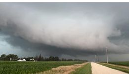
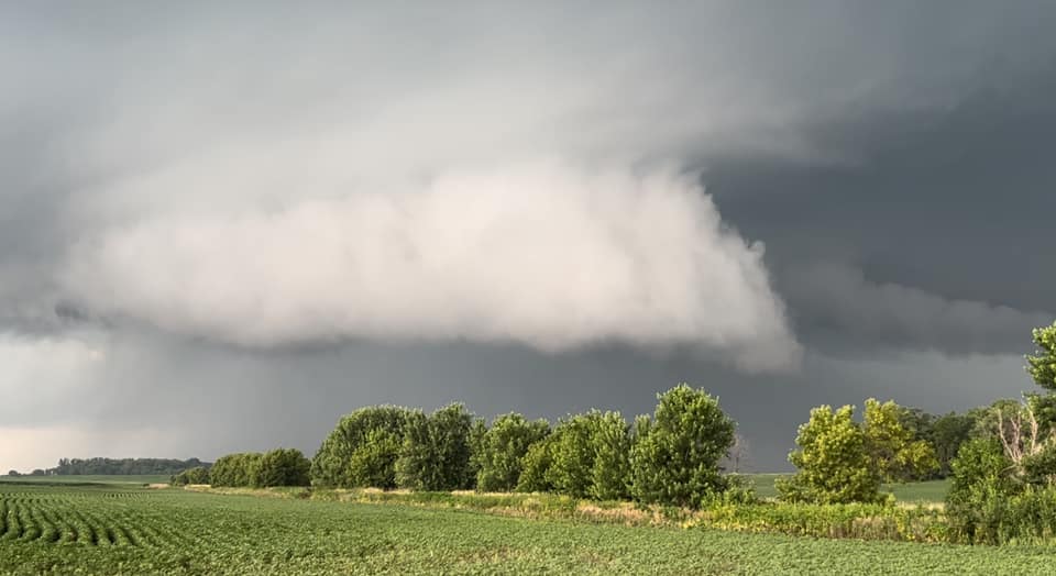
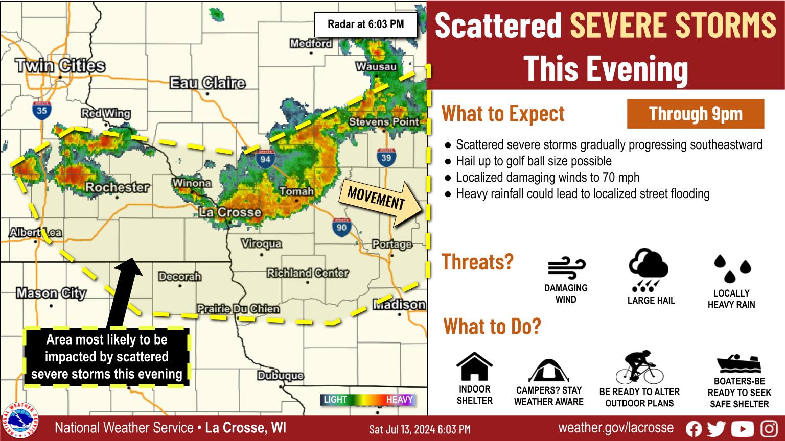
Two main rounds of storms moved through the region over the weekend of July 13-14. The first developed Saturday afternoon with storms quickly organizing and intensifying as they moved into southeast Minnesota and west-central Wisconsin. These storms quickly morphed into a bow echo that produced substantial tree damage as it raced eastward across Trempealeau and Jackson counties into central Wisconsin. A few other trailing storms produced large hail up to 2" in diameter (mainly within the Mississippi River Valley) and scattered wind damage across southeast Minnesota. A second round of storms developed Saturday night in the very humid airmass overhead. Heavy rain with these storms, falling over areas that had already received substantial rainfall from the first round of storms, led to localized flash flooding and rapidly rising rivers Sunday morning across western Wisconsin. |
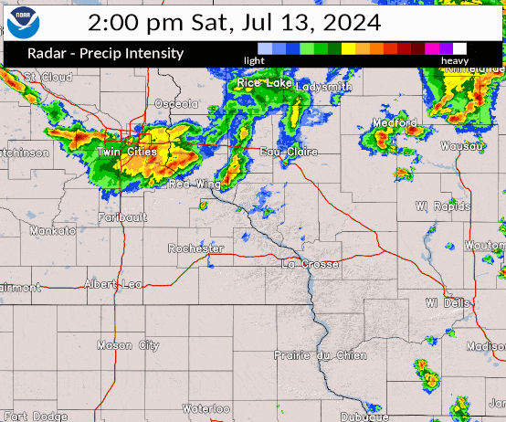 Radar loop from 2pm CDT Saturday through 7am CDT Sunday |
Storm Reports:
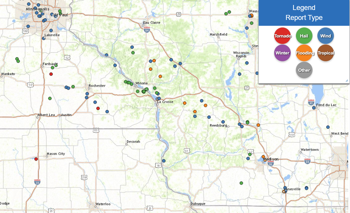 Storm reports from Saturday afternoon through Sunday morning |
..TIME... ...EVENT... ...CITY LOCATION... ...LAT.LON...
..DATE... ....MAG.... ..COUNTY LOCATION..ST.. ...SOURCE....
..REMARKS..
0310 PM Tstm Wnd Gst Kellogg 44.31N 92.00W
07/13/2024 M58 MPH Wabasha MN Mesonet
Observation at station MN069.
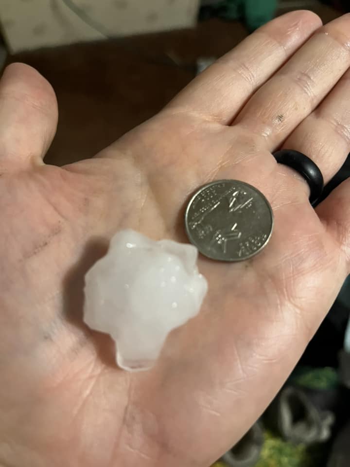
0340 PM Hail Gilmanton 44.47N 91.68W
07/13/2024 M1.00 Inch Buffalo WI Public
0340 PM Tstm Wnd Dmg 3 SSW Mondovi 44.54N 91.70W
07/13/2024 Buffalo WI Public
Several trees down between Gilmanton and
Mondovi.
0359 PM Tstm Wnd Dmg 2 E Independence 44.36N 91.37W
07/13/2024 Trempealeau WI Emergency Mngr
Trees and power lines down across central
Trempealeau County, mainly Independence and
Whitehall areas.
0426 PM Tstm Wnd Dmg Hixton 44.38N 91.01W
07/13/2024 Jackson WI Law Enforcement
Power lines and trees down in Hixton area.
0435 PM Tstm Wnd Dmg 4 NE Disco 44.30N 90.94W
07/13/2024 Jackson WI NWS Employee
12 inch diameter tree uprooted.
0439 PM Tstm Wnd Dmg 2 N Black River Falls 44.33N 90.85W
07/13/2024 Jackson WI Public
Several trees snapped and uprooted.
0500 PM Hail Pickwick 43.98N 91.60W
07/13/2024 E1.00 Inch Winona MN County Official
0505 PM Hail Trempealeau 44.01N 91.44W
07/13/2024 E0.75 Inch Trempealeau WI Public
Report from mPING: Dime (0.75 in.).
0505 PM Hail Trempealeau 44.00N 91.44W
07/13/2024 E1.00 Inch Trempealeau WI Public
0505 PM Hail Trempealeau 44.01N 91.44W
07/13/2024 M1.00 Inch Trempealeau WI Public
Public report via Facebook photo.
0508 PM Hail 6 N Nodine 44.00N 91.46W
07/13/2024 E1.75 Inch Winona MN County Official
0512 PM Hail Trempealeau 44.01N 91.44W
07/13/2024 E1.50 Inch Trempealeau WI Public
0515 PM Hail Holmen 43.96N 91.26W
07/13/2024 E1.00 Inch La Crosse WI Public
0522 PM Hail 3 NE New Amsterdam 44.02N 91.30W
07/13/2024 M0.75 Inch La Crosse WI Public
Report from mPING: Dime (0.75 in.).
0526 PM Tstm Wnd Dmg 1 SE Holmen 43.95N 91.24W
07/13/2024 La Crosse WI Public
Report from mPING: 1-inch tree limbs broken;
Shingles blown off.
0534 PM Tstm Wnd Dmg Onalaska 43.89N 91.22W
07/13/2024 La Crosse WI Public
Corrects time from previous tstm wnd dmg
report from Onalaska. Downed trees, power
outages. Public report via Twitter.
0535 PM Hail Minnesota City 44.09N 91.75W
07/13/2024 E1.25 Inch Winona MN Public
Relayed via County Official.
0537 PM Tstm Wnd Gst 2 NNE French Island 43.88N 91.25W
07/13/2024 M63 MPH La Crosse WI ASOS
Corrects previous non-tstm wnd gst report
from 2 NNE French Island. ASOS station KLSE
La Crosse Regional Airport.
0538 PM Tstm Wnd Dmg Onalaska 43.89N 91.22W
07/13/2024 La Crosse WI Amateur Radio
Numerous trees and power lines down around
town.
0547 PM Hail 1 SE Rollingstone 44.10N 91.81W
07/13/2024 M2.00 Inch Winona MN County Official
0547 PM Hail 1 W Minnesota City 44.09N 91.77W
07/13/2024 M2.00 Inch Winona MN Public
0548 PM Tstm Wnd Dmg 5 E New Rome 44.20N 89.80W
07/13/2024 Adams WI Public
Numerous trees down in the Lake Arrowhead
and Lake Sherwood subdivisions.
0550 PM Tstm Wnd Dmg 4 NE Wilton 43.86N 90.47W
07/13/2024 Monroe WI Public
Branches and power lines down.
0552 PM Hail Goodview 44.07N 91.71W
07/13/2024 M2.00 Inch Winona MN Public
0553 PM Tstm Wnd Gst 2 NNE French Island 43.88N 91.25W
07/13/2024 M66 MPH La Crosse WI ASOS
ASOS station KLSE La Crosse Regional
Airport.
0615 PM Tstm Wnd Gst 2 ESE Dodge Center 44.02N 92.82W
07/13/2024 M46 MPH Dodge MN AWOS
AWOS station KTOB Dodge Center Airport.
0616 PM Tstm Wnd Dmg Hillsboro 43.65N 90.34W
07/13/2024 Vernon WI Emergency Mngr
Trees and power lines down in Hillsboro.
0625 PM Hail 1 NE Kasson 44.04N 92.74W
07/13/2024 M0.75 Inch Dodge MN Public
Report from mPING: Dime (0.75 in.).
0629 PM Tstm Wnd Dmg 1 WNW Dodge Center 44.03N 92.86W
07/13/2024 Dodge MN County Official
Downed power poles.
0637 PM Tstm Wnd Dmg 4 S Rochester 43.95N 92.49W
07/13/2024 Olmsted MN Broadcast Media
Several large limbs down, including on a
house.
0640 PM Hail Pickwick 43.98N 91.49W
07/13/2024 E0.70 Inch Winona MN County Official
0640 PM Tstm Wnd Dmg 1 NE Rockton 43.66N 90.59W
07/13/2024 Vernon WI Public
Large tree branches down.
0645 PM Hail 5 E Pickwick 43.98N 91.50W
07/13/2024 E1.75 Inch Winona MN County Official
0645 PM Tstm Wnd Gst 3 NNW Stewartville 43.90N 92.50W
07/13/2024 M64 MPH Olmsted MN ASOS
ASOS station KRST Rochester International
Airport.
0650 PM Hail Trempealeau 44.01N 91.44W
07/13/2024 M1.00 Inch Trempealeau WI Public
0650 PM Hail 5 NNW Nodine 43.97N 91.49W
07/13/2024 E1.50 Inch Winona MN County Official
0651 PM Tstm Wnd Gst 3 NNW Stewartville 43.90N 92.50W
07/13/2024 M81 MPH Olmsted MN ASOS
ASOS station KRST Rochester International
Airport.
0700 PM Tstm Wnd Gst 5 WSW Cummingsville 43.84N 92.35W
07/13/2024 M74 MPH Fillmore MN Trained Spotter
0703 PM Funnel Cloud 2 WNW Fillmore 43.76N 92.30W
07/13/2024 Fillmore MN Emergency Mngr
Delayed report. Video of a funnel cloud
northeast of Spring Valley.
0725 PM Tstm Wnd Dmg 2 SSW Fountain 43.72N 92.14W
07/13/2024 Fillmore MN Public
Downed trees and power poles.
0920 PM Tstm Wnd Gst 3 N Prairie Du Chien 43.09N 91.14W
07/13/2024 M67 MPH Crawford WI Trained Spotter
0220 AM Flood Whitehall 44.37N 91.31W
07/14/2024 Trempealeau WI Law Enforcement
Water over some roads in Whitehall.
0400 AM Flash Flood 2 N Melvina 43.83N 90.77W
07/14/2024 Monroe WI Emergency Mngr
EM reported rock slides along county 27
between Sparta and Cashton.
0450 AM Flash Flood 6 E Arcadia 44.26N 91.37W
07/14/2024 Trempealeau WI Law Enforcement
Flooding occurring along hwy 95 between
Arcadia and Blair.
0613 AM Flash Flood 2 W Kendall 43.80N 90.40W
07/14/2024 Monroe WI Emergency Mngr
Reported roads closed across parts of
southern Monroe County. Kendall is most
impacted at the current time.
0830 AM Flood 3 SE Beach Corners 44.17N 91.20W
07/14/2024 Trempealeau WI Public
Delayed report: Public reported water
completely over the Rogness Coulee Rd.
Location on Rogness Coulee is unknown.
0945 AM Flood Ontario 43.72N 90.59W
07/14/2024 Vernon WI Emergency Mngr
Reports of water approximately 4 feet deep
at the Highway 33 and 131 north intersection
near wastewater treatment plant.
&&
$$
Rain Reports
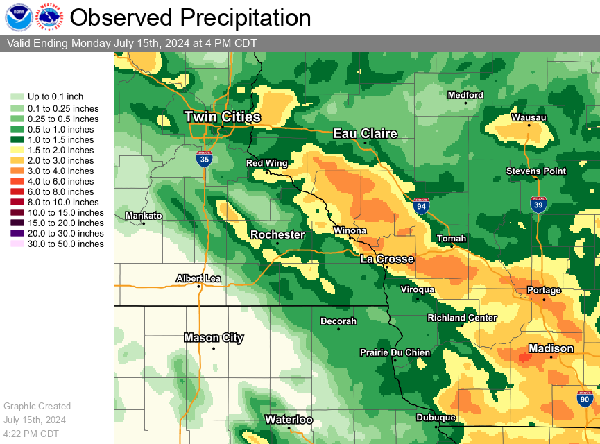 Rainfall totals from Saturday through Monday morning |
...WEEKEND RAINFALL TOTALS...

Location                     Amount    Time/Date       Lat/Lon

...Iowa...

...Allamakee County...
Harpers Ferry 6.4 SSW        0.89 in   0700 AM 07/14   43.11N/91.20W
Postville 5.5 NE             0.74 in   0700 AM 07/14   43.14N/91.49W
Lansing 4.1 NW               0.48 in   0700 AM 07/14   43.40N/91.29W
3 S Dorchester               0.47 in   0700 AM 07/14   43.42N/91.51W

...Clayton County...
Guttenberg Dam 10            0.98 in   0600 AM 07/14   42.79N/91.10W
McGregor 6.4 WNW             0.96 in   0750 AM 07/14   43.07N/91.29W
1 WSW Marquette              0.78 in   0900 AM 07/14   43.04N/91.21W
Elkader 6SSW                 0.50 in   0700 AM 07/14   42.78N/91.45W
Littleport                   0.48 in   0845 AM 07/14   42.75N/91.37W
Big Spring Fish Hatchery     0.47 in   0900 AM 07/14   42.91N/91.47W
Elkader 6.8 WSW              0.39 in   0630 AM 07/14   42.81N/91.52W

...Howard County...
Lime Springs 1.5 N           0.61 in   0700 AM 07/14   43.47N/92.28W

...Winneshiek County...
Decorah 4.9SE                1.18 in   0700 AM 07/14   43.26N/91.70W
7 ENE Decorah                0.76 in   0810 AM 07/14   43.34N/91.64W

...Minnesota...

...Dodge County...
Mantorville                  2.76 in   0728 PM 07/13   44.07N/92.76W
Kasson 5.7 SE                1.74 in   0630 AM 07/14   43.96N/92.68W
Mantorville 1.9 ESE          1.32 in   0700 AM 07/14   44.05N/92.72W
Claremont 2.5 ESE            1.05 in   0700 AM 07/14   44.04N/92.95W
Claremont 3.1 S              0.65 in   0700 AM 07/14   44.00N/92.99W
Hayfield 0.6 WNW             0.31 in   0700 AM 07/14   43.89N/92.86W
Hayfield 0.3 SSE             0.27 in   0630 AM 07/14   43.89N/92.85W

...Fillmore County...
Lanesboro 0.2 SSW            1.53 in   0600 AM 07/14   43.72N/91.97W
Chatfield 9.0 ESE            1.53 in   0700 AM 07/14   43.79N/92.03W
Preston 3.2 NNE              1.53 in   0700 AM 07/14   43.71N/92.05W
Preston                      1.50 in   0700 AM 07/14   43.67N/92.07W
Preston 2.7 NE               1.42 in   0700 AM 07/14   43.70N/92.05W
Mabel                        1.30 in   0545 AM 07/14   43.52N/91.76W
Harmony 0.3 S                1.15 in   0700 AM 07/14   43.55N/92.01W
1 NNW Fillmore               0.70 in   0930 AM 07/14   43.76N/92.27W
Spring Valley 0.9 NNW        0.64 in   0700 AM 07/14   43.70N/92.40W
Wykoff 3.1 NW                0.60 in   0700 AM 07/14   43.74N/92.31W
Spring Valley                0.46 in   0700 AM 07/14   43.69N/92.39W
Lanesboro                    0.28 in   0830 AM 07/14   43.72N/91.98W

...Houston County...
La Crescent 0.7 N            1.95 in   0730 AM 07/14   43.84N/91.30W
Caledonia                    0.92 in   0600 AM 07/14   43.63N/91.50W
Brownsville 3.8 SW           0.88 in   0700 AM 07/14   43.65N/91.32W
Caledonia 5.3 NNE            0.86 in   0600 AM 07/14   43.71N/91.46W
Caledonia 5.4 S              0.81 in   0800 AM 07/14   43.56N/91.51W
Caledonia 7.7 SE             0.77 in   0800 AM 07/14   43.57N/91.38W
Houston 5.3 SW               0.69 in   0700 AM 07/14   43.71N/91.65W
Houston 8.6 WSW              0.65 in   0715 AM 07/14   43.69N/91.72W
Hokah 4 NW                   0.64 in   0700 AM 07/14   43.80N/91.43W
1 ENE Mound Prairie          0.64 in   0700 AM 07/14   43.79N/91.42W
Mound Prairie                0.63 in   0845 AM 07/14   43.78N/91.45W
Eitzen 3.8 E                 0.49 in   0745 AM 07/14   43.50N/91.39W

...Mower County...
Waltham 2.9 SW               0.22 in   0800 AM 07/14   43.79N/92.91W

...Olmsted County...
Byron 5.5 SE                 1.76 in   0659 AM 07/14   43.97N/92.58W
3 SW Cummingsville           1.70 in   0803 AM 07/14   43.85N/92.30W
Rochester International Airp 1.70 in   0854 AM 07/14   43.90N/92.50W
Stewartville 4.3 E           1.63 in   0600 AM 07/14   43.86N/92.40W
Byron 0.4 SSE                1.46 in   0658 AM 07/14   44.03N/92.64W
Chatfield 2.7 NNW            1.34 in   0800 AM 07/14   43.88N/92.22W
2 W High Forest              1.25 in   0700 AM 07/14   43.85N/92.59W
Rochester 1.5 WSW            1.20 in   0600 AM 07/14   44.00N/92.50W
Rochester 3.1 SW             1.19 in   0700 AM 07/14   43.98N/92.52W
5 WSW Rochester              1.19 in   0900 AM 07/14   43.98N/92.56W
3 W Rochester                1.17 in   0830 AM 07/14   44.02N/92.53W
Rochester 5.1 S              1.06 in   0700 AM 07/14   43.94N/92.48W
2 NNW Rochester              1.05 in   0700 AM 07/14   44.05N/92.49W
Rochester 3.5 NW             1.04 in   0700 AM 07/14   44.05N/92.53W
Byron 3.6 NNE                0.94 in   0700 AM 07/14   44.09N/92.61W
Chatfield 1.7 NE             0.90 in   0800 AM 07/14   43.86N/92.17W
Rochester 3.0 N              0.89 in   0700 AM 07/14   44.06N/92.47W
Rochester 4.7 N              0.86 in   0700 AM 07/14   44.08N/92.48W
Elgin 2SSW                   0.81 in   0700 AM 07/14   44.10N/92.27W
4 NNW Rochester              0.80 in   0700 AM 07/14   44.07N/92.49W
Rochester 3.9 NNW            0.79 in   0800 AM 07/14   44.07N/92.51W
Rochester 5.8 ENE            0.72 in   0700 AM 07/14   44.05N/92.37W
Rochester 0.2 SW             0.66 in   0700 AM 07/14   44.01N/92.48W
2 NE Rochester               0.62 in   0600 AM 07/14   44.04N/92.44W
Rochester 1.3 ENE            0.60 in   0700 AM 07/14   44.02N/92.45W
Rochester 1.6 ENE            0.58 in   0800 AM 07/14   44.03N/92.45W
Rochester 3.9 ESE            0.55 in   0700 AM 07/14   43.99N/92.41W
Rochester 5.6 E              0.51 in   0700 AM 07/14   44.00N/92.37W
3 ENE Rochester              0.41 in   0830 AM 07/14   44.03N/92.43W
Rochester-Beltline Bear Cree 0.36 in   0830 AM 07/14   44.01N/92.45W
Rochester-Cascade Creek      0.35 in   0830 AM 07/14   44.03N/92.47W
Elba 4.7 SW                  0.22 in   0800 PM 07/13   44.04N/92.09W
1 W Oronoco                  0.21 in   0930 AM 07/14   44.17N/92.55W

...Wabasha County...
Wabasha                      2.10 in   0445 PM 07/13   44.37N/92.05W
Wabasha 6.2 WNW              2.08 in   0700 AM 07/14   44.39N/92.16W
Theilman 1 SSW               2.00 in   0730 AM 07/14   44.28N/92.19W
1 N Kellogg                  1.49 in   0900 AM 07/14   44.32N/92.00W
Kellogg 0.1 N                1.44 in   0630 AM 07/14   44.31N/92.00W
Lake City 0.9 NNE            1.23 in   0700 AM 07/14   44.45N/92.27W
Lake City 0.7 SE             1.22 in   0800 AM 07/14   44.43N/92.27W
Lake City 9.7 SW             1.05 in   0700 AM 07/14   44.34N/92.41W
Zumbro Falls 3.5 SSW         0.43 in   0700 AM 07/14   44.24N/92.46W
Mazeppa 3.3 SSE              0.22 in   0745 AM 07/14   44.23N/92.51W

...Winona County...
Winona 6.9 ESE               2.98 in   0650 AM 07/14   44.00N/91.55W
Winona 2.0 ESE               2.28 in   0700 AM 07/14   44.04N/91.63W
Winona 1.9 ESE               2.24 in   0752 AM 07/14   44.04N/91.63W
Dakota                       2.12 in   0315 AM 07/14   43.91N/91.36W
1 NW Winona                  2.00 in   1109 AM 07/14   44.05N/91.67W
3 NE Nodine                  1.96 in   0930 AM 07/14   43.94N/91.41W
Minneiska 1.1 SW             1.67 in   0700 AM 07/14   44.18N/91.88W
Beaver                       1.60 in   0845 AM 07/14   44.15N/92.00W
4.2 N Rollingstone           1.43 in   0715 AM 07/14   44.16N/91.81W
Altura 0.7 NNE               1.27 in   0700 AM 07/14   44.07N/91.94W
Whitewater State Park        1.24 in   0830 AM 07/14   44.05N/92.05W
1 WSW Elba                   1.23 in   0845 AM 07/14   44.09N/92.03W
3 SW Elba                    1.14 in   0330 AM 07/14   44.06N/92.05W
Winona 5.1 WSW               1.05 in   0600 AM 07/14   44.03N/91.77W
Lewiston 9.1 SSE             0.77 in   0700 AM 07/14   43.86N/91.80W

...Wisconsin...

...Adams County...
Nekoosa 8.0 SSE              1.61 in   0700 AM 07/14   44.21N/89.85W
Oxford 4.3 W                 1.38 in   0800 AM 07/14   43.79N/89.65W
Oxford 4.0 W                 1.29 in   0700 AM 07/14   43.79N/89.64W
0.6 W Friendship             1.10 in   0730 AM 07/14   43.98N/89.83W
Friendship 6.4 NNE           0.95 in   0700 AM 07/14   44.06N/89.79W

...Buffalo County...
Independence 9.1 NW          3.61 in   0700 AM 07/14   44.46N/91.55W
Mondovi 12.1 SSE             2.95 in   0630 AM 07/14   44.40N/91.60W
Cochrane 4.2 NE              1.78 in   0715 AM 07/14   44.27N/91.77W
Cochrane 0.6 ESE             1.21 in   0700 AM 07/14   44.23N/91.82W
Mondovi                      0.79 in   0700 PM 07/13   44.56N/91.67W

...Clark County...
COLBY                        0.64 in   0925 AM 07/14   44.91N/90.32W
Greenwood 0.6 NNW            0.42 in   0700 AM 07/14   44.77N/90.60W
Owen 1E                      0.26 in   0600 AM 07/14   44.95N/90.55W

...Crawford County...
Steuben                      0.89 in   0845 AM 07/14   43.18N/90.86W
1 S De Soto                  0.79 in   0630 AM 07/14   43.41N/91.19W
Eastman 2.4 NNE              0.72 in   0700 AM 07/14   43.20N/91.00W
Gays Mills 1.0 NE            0.66 in   0700 AM 07/14   43.33N/90.84W
2.8 E Harpers Ferry          0.63 in   0915 AM 07/14   43.21N/91.10W

...Grant County...
Stitzer 1.8 SE               1.50 in   0700 AM 07/14   42.91N/90.60W
Bloomington 3.5 N            1.20 in   0650 AM 07/14   42.94N/90.92W
Prairie Du Chien 9.9 SE      1.00 in   0700 AM 07/14   42.95N/90.99W
Patch Grove 0.1 NNW          0.88 in   0700 AM 07/14   42.94N/90.97W
Muscoda 0.5 WSW              0.72 in   0706 AM 07/14   43.18N/90.44W
1 NE Platteville             0.68 in   0600 AM 07/14   42.75N/90.46W

...Jackson County...
Melrose 3.6 W                2.99 in   0630 AM 07/14   44.13N/91.07W
Black River Falls            1.19 in   0720 AM 07/14   44.29N/90.85W
Mather 3NW                   0.82 in   0700 AM 07/14   44.17N/90.35W

...Juneau County...
1.0 E Mauston                2.97 in   0630 AM 07/14   43.79N/90.06W
Mauston                      1.80 in   1020 PM 07/14   43.80N/90.08W
NECEDAH NWR RY DAM NECEDAH 5 1.37 in   0910 AM 07/14   44.06N/90.17W
Necedah 5.0 ESE              0.80 in   0700 AM 07/14   43.99N/89.99W
3 SSE Lemonweir              0.60 in   0912 PM 07/13   43.75N/90.00W

...La Crosse County...
Melrose 8.2 SSW              3.50 in   0800 AM 07/14   44.02N/91.06W
Onalaska 0.6 SW              3.00 in   0800 AM 07/14   43.88N/91.23W
Onalaska 2N                  2.77 in   0700 AM 07/14   43.91N/91.23W
Onalaska 0.5 WSW             2.73 in   0700 AM 07/14   43.89N/91.23W
La Crosse Regional Airport   2.54 in   0853 AM 07/14   43.88N/91.25W
Holmen 2SE                   2.43 in   0700 AM 07/14
La Crosse 1.3 SSE            2.10 in   0645 AM 07/14   43.81N/91.22W
Coon Valley 4.5 NNW          1.37 in   0700 AM 07/14   43.76N/91.06W
2 E La Crosse                0.63 in   0700 PM 07/13   43.82N/91.19W

...Monroe County...
Cashton 4.8 N                4.02 in   0700 AM 07/14   43.81N/90.76W
Tomah 7.5 SSW                3.03 in   0700 AM 07/14   43.90N/90.58W
Warrens 4.7 WSW              0.96 in   0700 AM 07/14   44.10N/90.59W

...Richland County...
Cazenovia 4.4 SSW            1.33 in   0700 AM 07/14   43.47N/90.23W
Richland Center 4 N          1.15 in   0700 AM 07/14   43.40N/90.39W
Richland Center 4.0 N        1.15 in   0800 AM 07/14   43.40N/90.39W

...Taylor County...
Athens 7.6 N                 0.30 in   0700 AM 07/14   45.14N/90.06W

...Trempealeau County...
1 NW Trempealeau             4.26 in   0700 AM 07/14   44.03N/91.46W
Arcadia                      4.18 in   0720 AM 07/14   44.25N/91.49W
Ettrick 4.0 WNW              3.06 in   0626 AM 07/14   44.19N/91.34W
Whitehall (IFLOWS)           2.96 in   0903 AM 07/14   44.37N/91.32W
Trempealeau 7.6 NNW          2.85 in   0700 AM 07/14   44.11N/91.48W
Galesville 4.7 E             2.76 in   0721 AM 07/14   44.08N/91.26W
Blair (IFLOWS)               2.64 in   0427 AM 07/14   44.30N/91.23W
Galesville 1.0 NE            2.31 in   0700 AM 07/14   44.10N/91.34W
0.8 SW Pigeon Falls (IFLOWS) 2.17 in   0534 AM 07/14   44.42N/91.22W
Osseo 0.4 E                  1.87 in   0600 AM 07/14   44.58N/91.21W
3 NW York                    1.65 in   0700 AM 07/14   44.50N/91.19W

...Vernon County...
Hillsboro 2 SW               2.55 in   0700 AM 07/14   43.63N/90.38W
0.5 E Viroqua                0.99 in   0700 AM 07/14   43.56N/90.88W
Stoddard 1.5 NE              0.83 in   0700 AM 07/14   43.67N/91.19W
Ontario                      0.81 in   0900 PM 07/13   43.72N/90.59W
De Soto 5.8 NE               0.77 in   0700 AM 07/14   43.48N/91.11W
Viroqua 0.8 ESE              0.74 in   0700 AM 07/14   43.55N/90.87W

Observations are collected from a variety of sources with varying
equipment and exposures. We thank all volunteer weather observers
for their dedication. Not all data listed are considered official.

$$
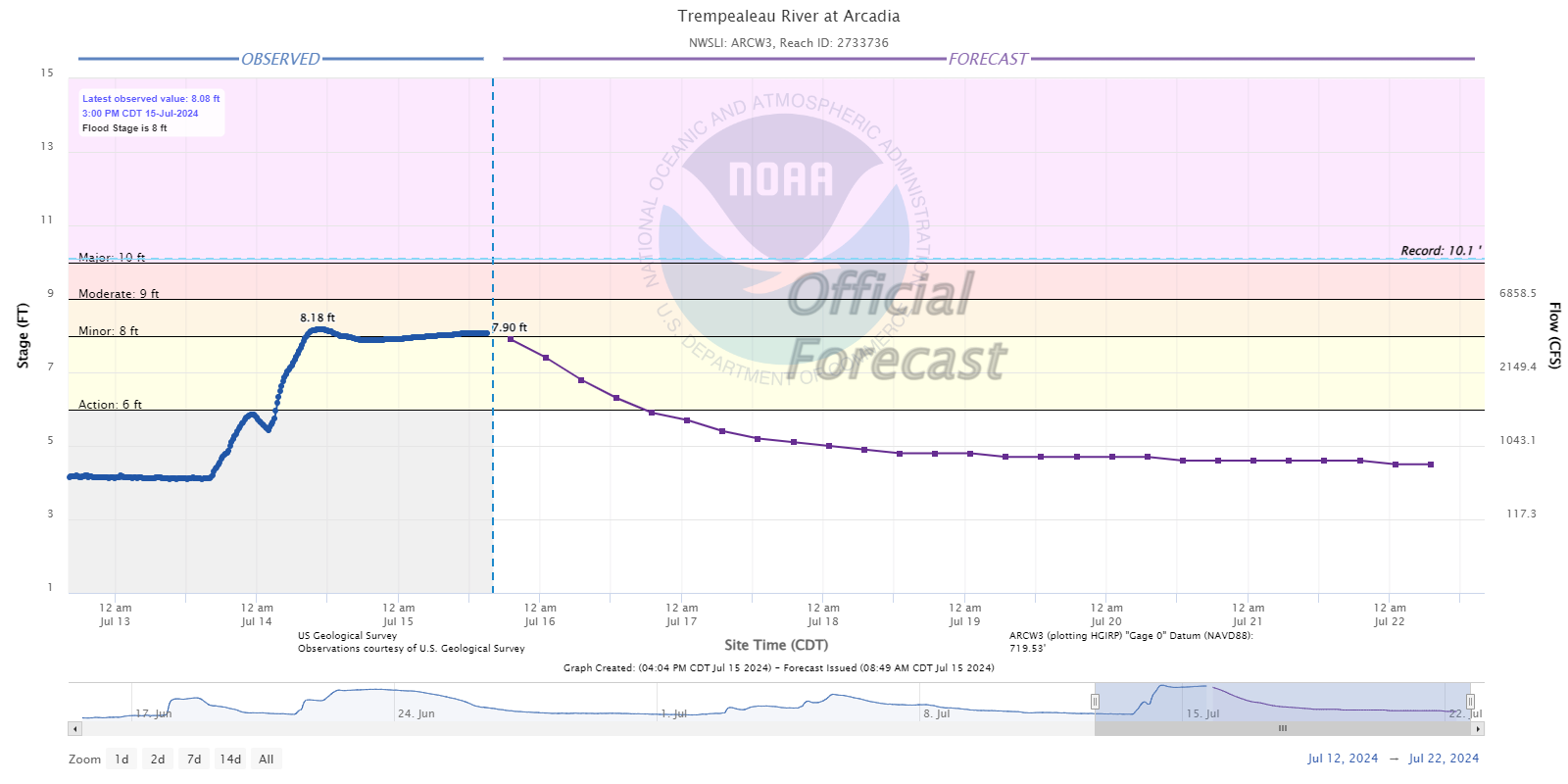
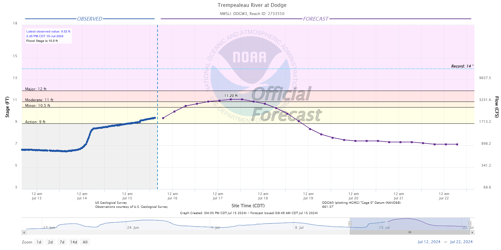
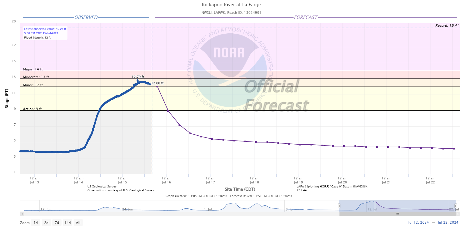
Flooding
Hydrographs
 |
 |
 |
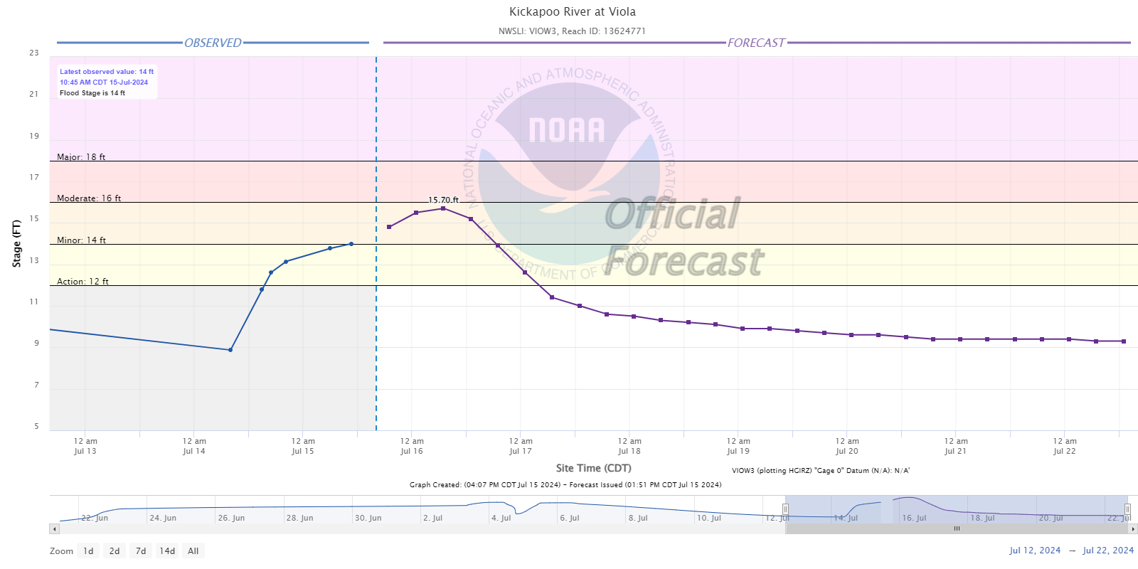 |
| Trempealeau River at Arcadia, WI | Trempealeau River at Dodge, WI | Kickapoo River at La Farge, WI | Kickapoo River at Viola, WI |
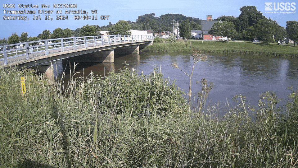
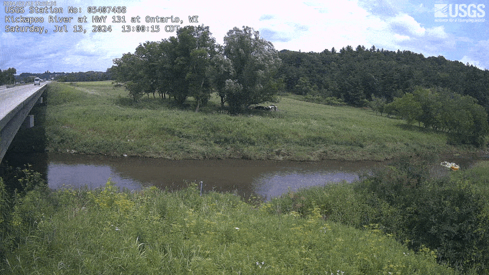
Timelapses
 |
 |
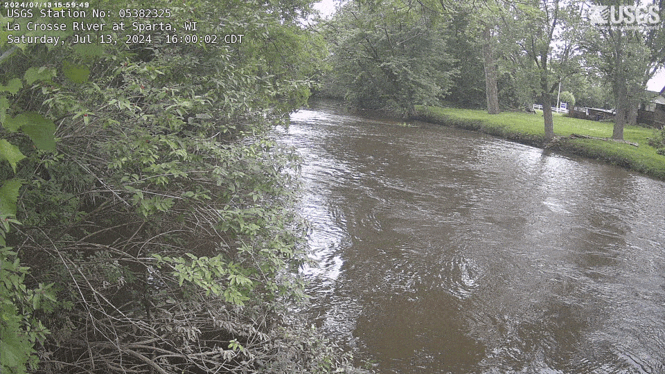 |
| Trempealeau River at Arcadia, WI | Kickapoo River at Ontario, WI | La Crosse River at Sparta, WI |
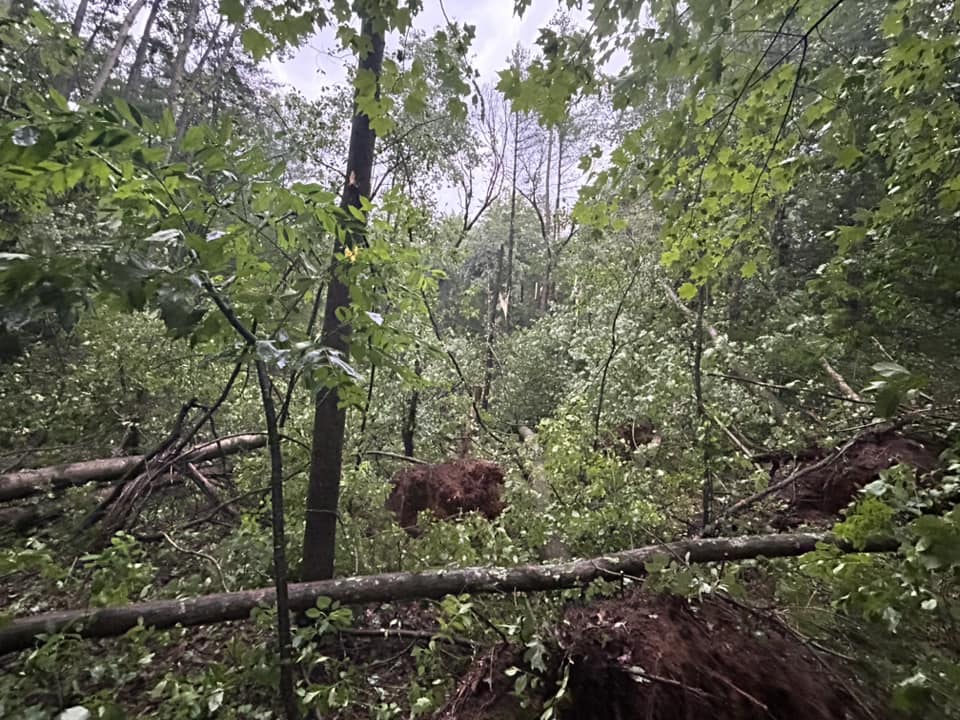
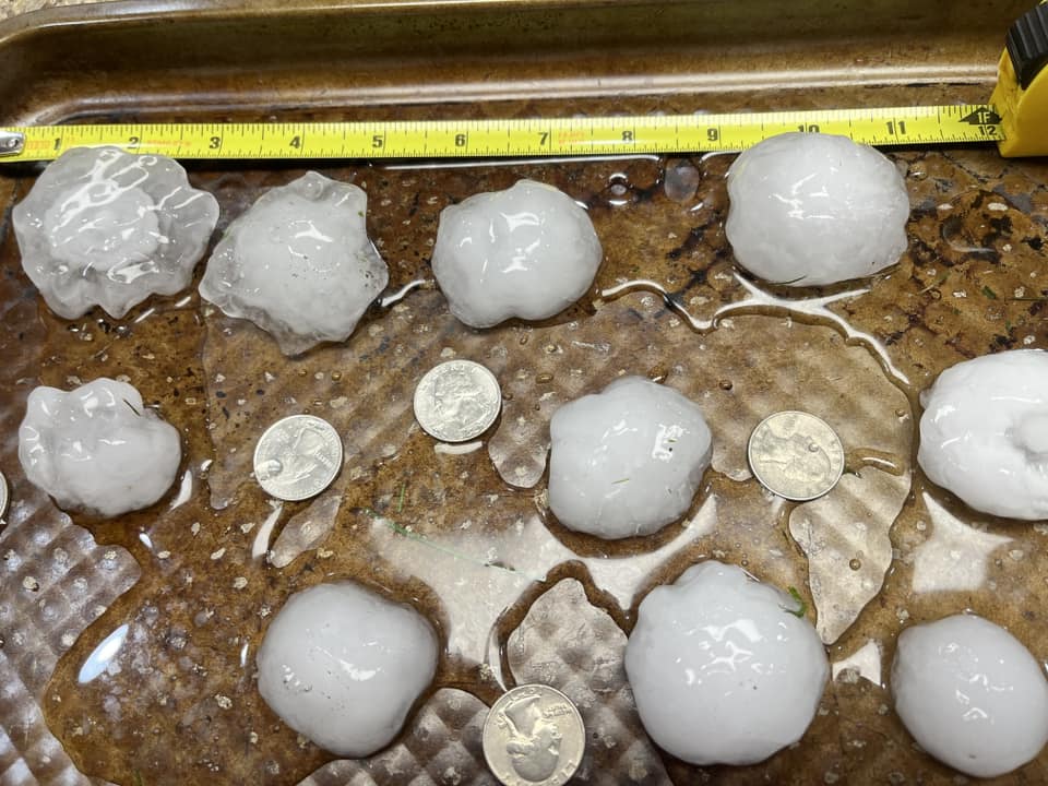
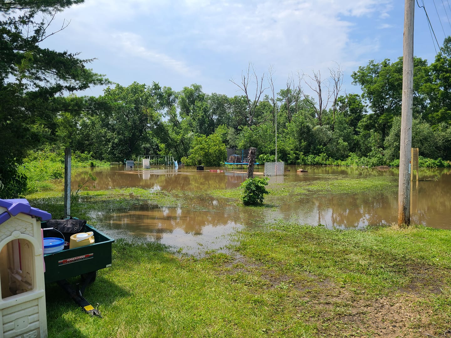
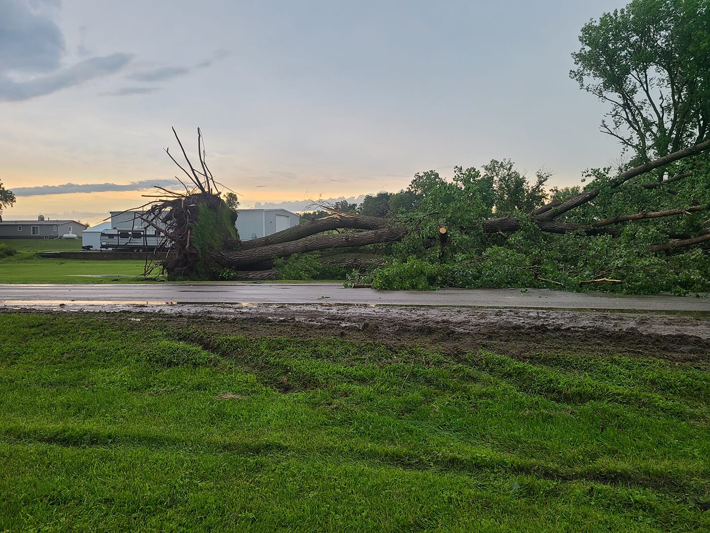
Photos & Video:
 |
 |
 |
 |
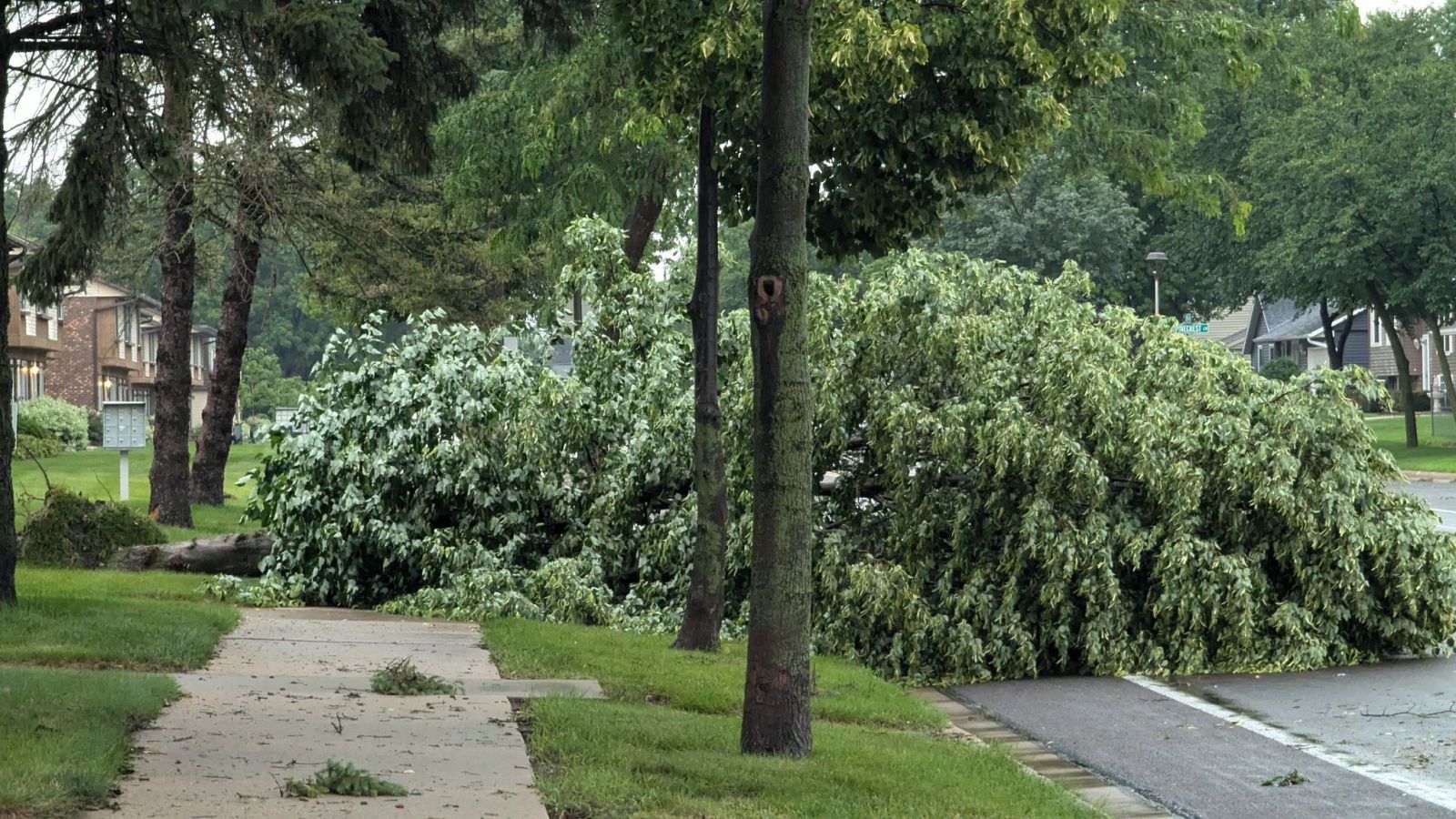
| North of Black River Falls, WI (Dan Taylor) |
Minnesota City, MN (Patti Horner Reick) |
Onalaska, WI (Dave Knudson) |
Trempealeau, WI (Dustin Osborn) |
 |
 |
 |
 |
| Northwest of Dodge Center, MN (Lorne Brinkman) |
West Concord, MN (Lorne Brinkman) |
Gilmanton, WI (Tony Hill) |
Gilmanton, WI (Tony Hill) |
Services:
Graphics
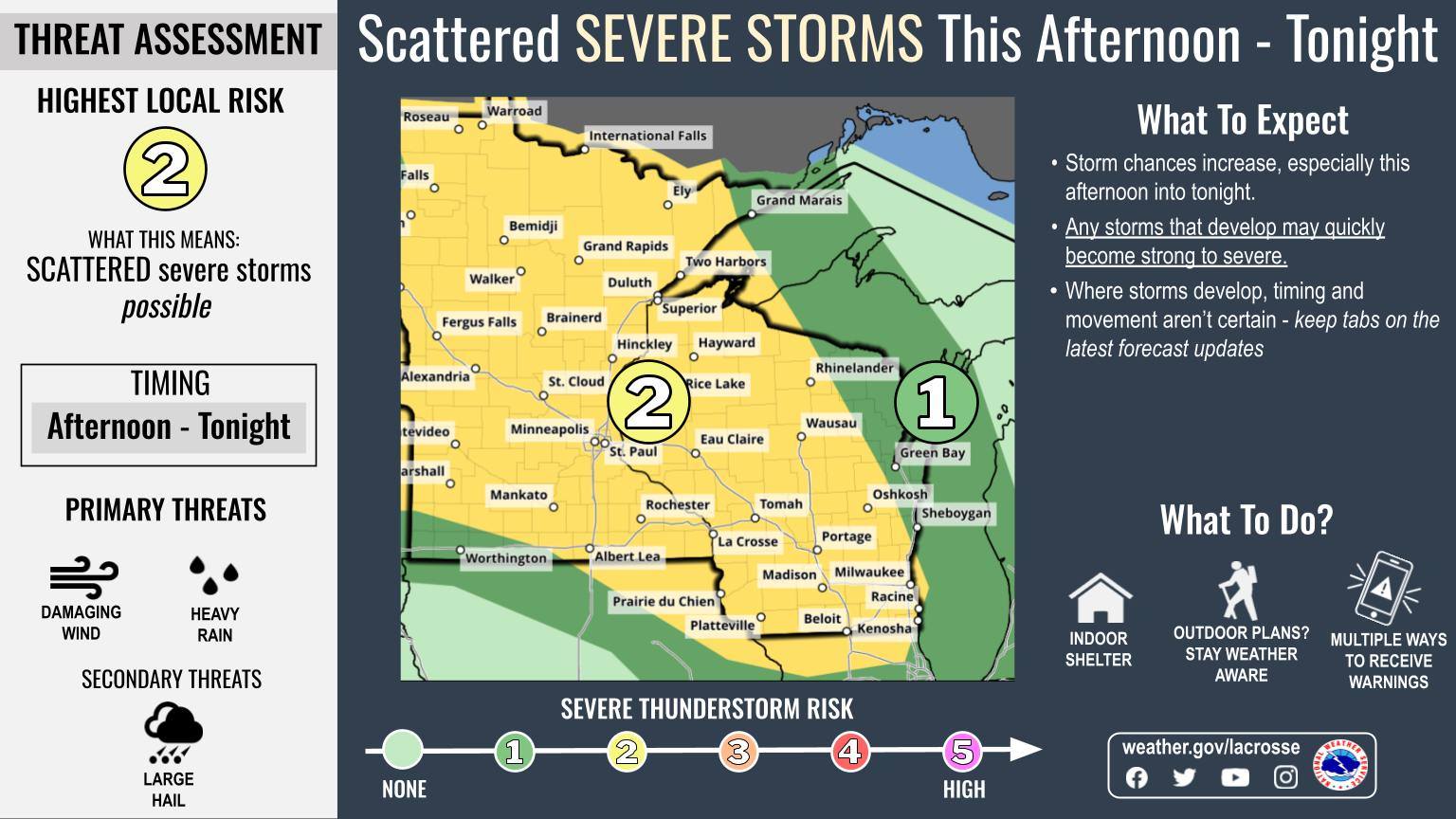 |
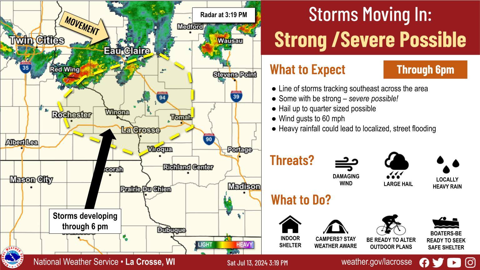 |
 |
| Severe Weather Risk Graphic | Storms Developing Graphic | Storm Progression Graphic |
Watches
 |
 |
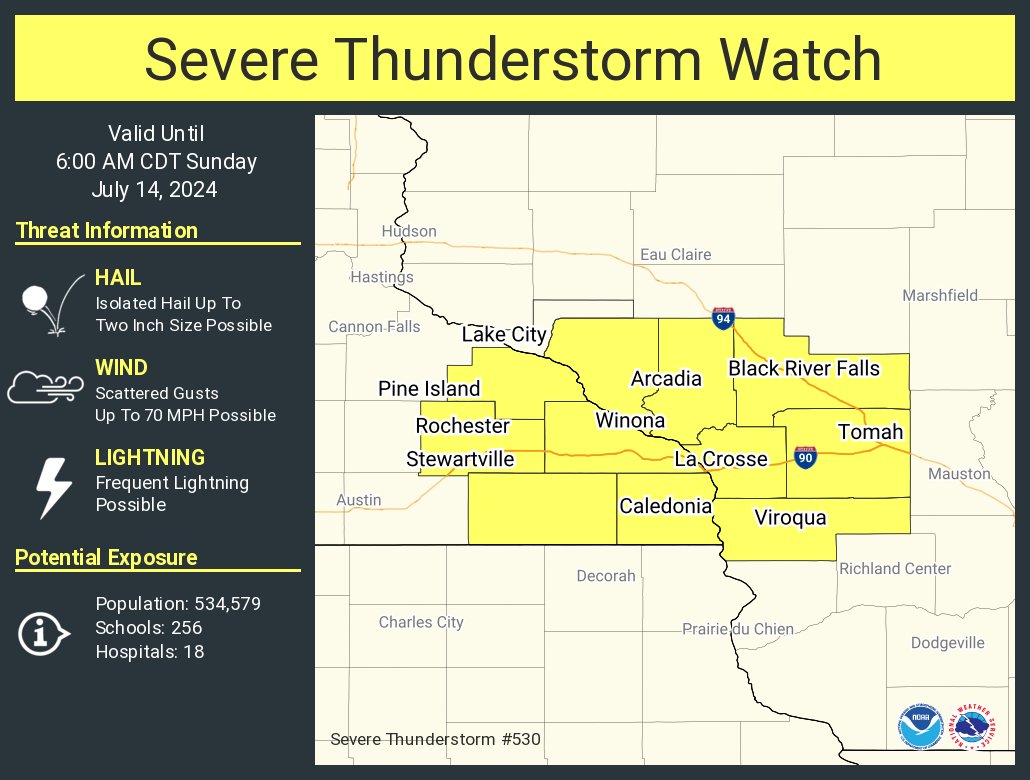 |
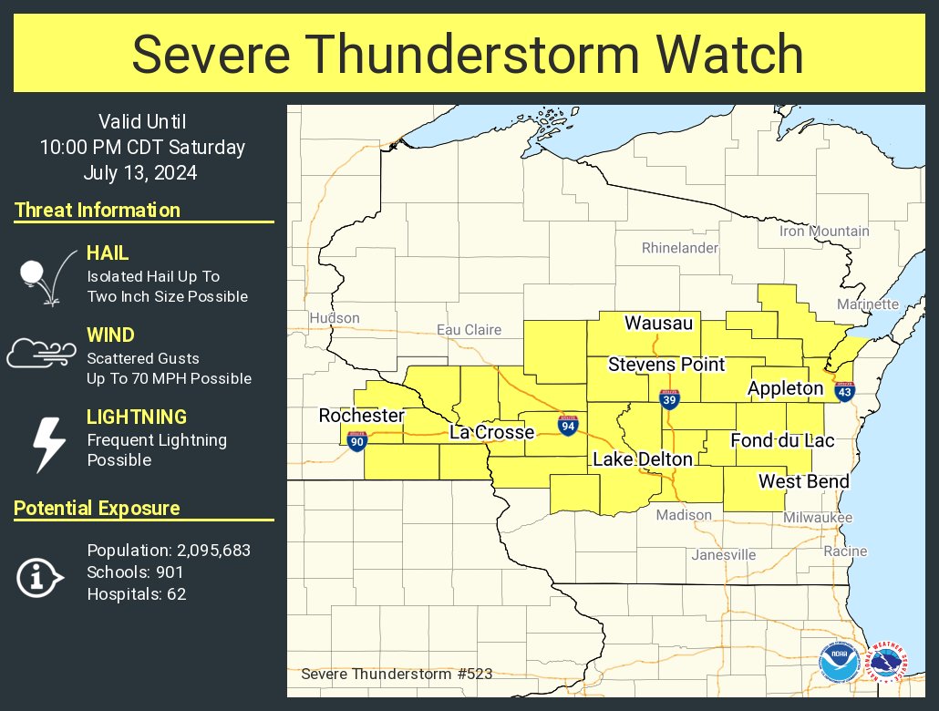
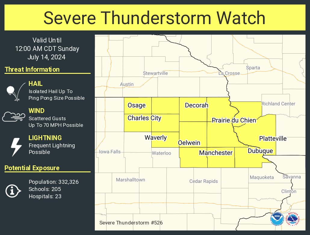
| Severe Thunderstorm Watch #523 | Severe Thunderstorm Watch #526 | Severe Thunderstorm Watch #530 |
 |
Media use of NWS Web News Stories is encouraged! Please acknowledge the NWS as the source of any news information accessed from this site. |
|


 Weather Story
 Weather Map
 Local Radar