Upper Mississippi River Climate Summary for January 2025:
Temperatures - Near Normal
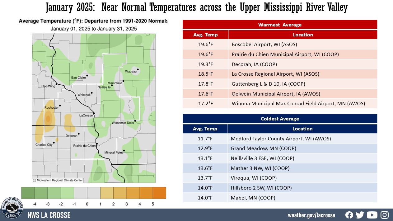
- During January 2025, average temperatures ranged from 11.7°F at Medford Taylor County Airport, WI (AWOS) to 19.6°F at Boscobel Airport, WI (ASOS) & Prairie du Chien Municipal Airport, WI (AWOS).
- Temperature anomalies ranged from 2°F colder-than-normal to 2°F warmer-than-normal.
- While temperatures ended the month near-normal, temperatures were highly variable during the month. There were 6 days well below normal and 7 days well above normal.
- There was a 88°F difference between the warmest and coldest temperatures in the Upper Mississippi River Valley.
- The warmest temperature was 62°F at Decorah, IA (COOP) on January 30. Meanwhile, the coldest temperature was -26°F near Theilman, MN (COOP) on January 21.
|
 |
Precipitation - Below to Well-Below Normal
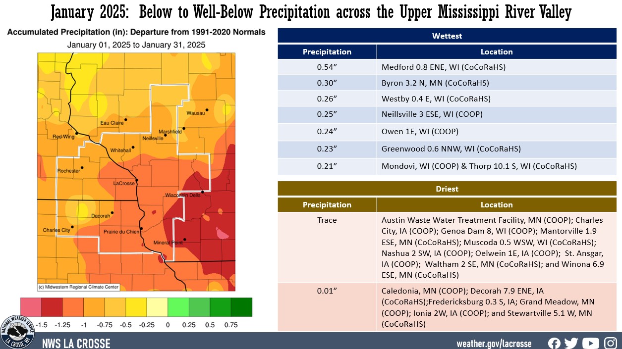
- Precipitation totals varied from just a trace at numerous sites to 0.54" near Medford, WI (CoCoRaHS).
- Precipitation anomalies ranged from a 0.5" to 1.5" drier than normal.
- The highest one-day precipitation was 0.20" near Byron from January 9 to January 10.
|
 |
| Snowfall - Less than Normal |
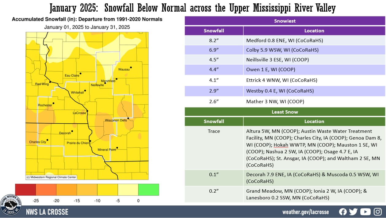
- Snowfall totals varied from just a trace at numerous sites to 8.2" near Medford, WI (CoCoRaHS).
- Snowfall anomalies ranged from near-normal to 15" below normal.
- The highest one-day snowfall was 3.5" near Owen, WI (COOP) from January 12 to January 13.
|
 |
Below are the January 2025 climate summaries for La Crosse, WI, and Rochester, MN.
La Crosse, WI
January 2025: La Crosse WI Saw Highly Variable Temperatures
and a Record Lack of Precipitation, Snowfall, and Snow Depth
...January 2025 Highlights...
Temperatures - Slightly Cooler than Normal
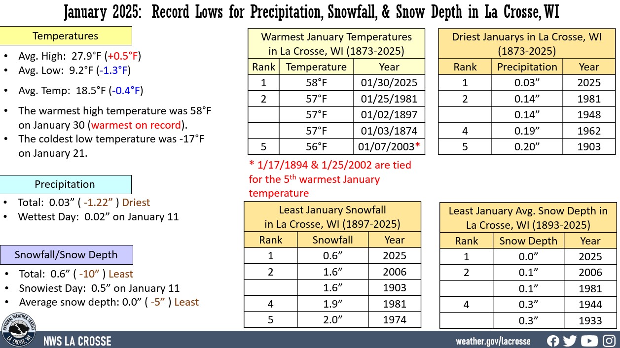
- The average temperature at La Crosse Regional Airport was 18.5°F. This was 0.4°F colder than the 1991-2020 normal of 18.5°F.
- The average high temperature was 27.9°F. This was 0.5°F warmer than the 1981-2020 normal of 27.4°F.
- The average low temperature was 9.2°F. This was 1.3°F colder than the 1981-2020 normal of 10.5°F.
- The warmest temperature was 58°F (warmest ever for a January) on January 30 and the coldest temperature was -17°F on January 21. This 75°F difference was tied for the 10th greatest for January with 1894, 1916, 1967, and 1974. The largest difference was 87°F in 2019 (the warmest temperature was 54°F and the coldest temperature was -33°F).
|
 |
The month was filled with temperature extremes...
- On January 21, the high temperature of -1°F ended a 1,435 day stretch with high temperatures above zero. This was the 5th longest stretch. The last time that occurred was on February 14, 2021 (-2°F). The longest stretch was 2,590 days from December 26, 1996 to January 28, 2004.
- On January 20, the high temperature was -1°. This was the first time that a high temperature was below zero with no snow on the ground for La Crosse. The previous record for the coldest high temperature with no snow on the ground was 0°F on December 29, 1917 and January 29, 1934.
- On January 20, the low temperature was -10°F. This tied December 17, 1964 for the 7th coldest low temperature with no snow on the ground. There have only been 67 days with a sub-zero low temperature with no snow on the ground.
- On January 21, the low temperature of -17°F ended a 1,090 day stretch with a low temperature -15°F or warmer. This was the 3rd longest stretch. The last time there was a temperature colder than -15°F was on January 26, 2022 (-18°F). The longest stretch was 1,434 days from January 27, 1943 to December 30, 1946.
- On January 21, the low temperature was -17°F. This was the 2nd coldest low temperature with no snow on the ground for La Crosse. The only day colder with no snow on the ground was -18°F on January 7, 1968.
- On January 28, the high temperature was 54°F. This not only set a daily high temperature record (previous record was 49°F in 1914), but it was also tied for the 10th warmest January temperature with January 24, 1981; January 26, 2002; January 27, 2002; January 27, 2006; and January 5, 2019.
- On January 30, the high temperature was 58°F. This not only set a daily high temperature record (previous record was 48°F in 1931), but also a monthly high temperature record (previous record was 57°F on January 3, 1874; January 1, 1897; and January 25, 1981). The daily high temperature record was broken by 10°F. This was the largest since December 15, 2021 when the daily high temperature was broken by 17°F.
- The daily temperature departure was plus or minus 10°F on 13 days. 7 were above normal (largest departure was 22°F on January 13) and 6 were below normal (largest departure was -23°F on January 20 and January 21).
- The temperature was 50°F or warmer on January 30 (58°F) and January 31 (50°F). This was the first time that La Crosse has had consecutive January days with high temperatures in the 50s.
- Temperatures were 0°F or colder on 7 days. The long-term normal is 10 days. The least was 0 days in 1891, 1923, 1990, 2002, and 2006. The most was 25 days in 1875.
- Temperatures were 50°F or warmer on 3 days. This tied 1880, 1894, and 1944 for the second most in January. The most was 5 days in 2002.
Daily temperature records began on October 15, 1872.
Precipitation - Driest January
- A total of 0.03" of precipitation fell at La Crosse Regional Airport.
- This was 1.22" below the 1991-2020 normal of 1.25".
- This was the driest January. The previous record was 0.14" in 1948 and 1981.
- The table below lists the ten driest Januarys in La Crosse, WI.
Driest Januarys
in La Crosse WI
1873-2025
Precipitation
Rank Total Year
---- ----- ----
1 0.03 inches 2025
2 0.14 inches 1981
0.14 inches 1948
4 0.19 inches 1962
5 0.20 inches 1903
6 0.25 inches 1957
0.25 inches 1887
8 0.27 inches 1961
9 0.28 inches 1984
10 0.30 inches 1955
- The greatest daily precipitation total was 0.02" on January 11.
- Measurable rain fell on 2 days and trace amounts fell on 12 days.
- Daily precipitation records began on October 15, 1872.
Snowfall - Least January Snowfall
- A total of 0.6" of snowfall was recorded by the NWS official snowfall near La Crosse Regional Airport.
- This was 11.2" below the 1981-2020 normal of 11.8".
- This was the least amount of snow in January. The previous record was 1.6" in 1903 and 2006.
- The table below lists the ten least amounts of January snowfalls in La Crosse, WI
Least Snowfall in January
in La Crosse WI
1897-2025
Snowfall
Rank Total Year
---- ----- ----
1 0.6 inches 2025
2 1.6 inches 2006
1.6 inches 1903
4 1.9 inches 1981
5 2.0 inches 1974
6 2.1 inches 1944
7 2.3 inches 1948
8 2.9 inches 1962
9 3.4 inches 1957
10 3.4 inches 1928
- The greatest daily snowfall total was 0.5" on January 11.
- Measurable snow fell on 2 days and trace amounts fell on 11 days.
- Daily snow records began on January 1, 1897.
Snow Depth - Least
The average snow depth was 0". This was 5" below the 1897-2025 long-term average of 5". This was the lowest January average. The previous record was 0.2" in 2006.
The table below lists the ten least average snow amounts of January snowfalls in La Crosse, WI
Least Avg. January Snow Depth
in La Crosse WI
1893-2025
Avg Snow Depth
Rank Total Year
---- ----- ----
1 0.0 inches 2025
2 0.2 inches 2006
3 0.3 inches 1981
0.3 inches 1933
5 0.4 inches 1944
6 0.6 inches 1934
7 0.7 inches 2003
0.7 inches 2002
9 0.9 inches 1921
0.9 inches 1897
- The greatest daily snow depth was a trace from January 11 through January 17 and from January 22 to January 23.
- There was trace amounts of snow on the ground on 9 days, and no days with measurable snow at 7 AM.
- This is the first time that this has occurred in January. The previous record was 27 days in 1981 and 2006.
- Daily snow depth records began on January 1, 1893.
...Records...
Daily...
- Record High (54°F) - Previous record was 49°F in 1914
- Record High (58°F) - Previous record was 48°F in 1931
Daily temperature records go back to October 15, 1872.
Monthly...
- Warmest High Temperature (58°F) - Previous record was 57°F on January 3, 1874; January 1, 1897; and January 25, 1981. Daily temperature records began on October 15, 1872.
- Driest (0.03") - Previous record was 0.14" in 1948 and 1981. Daily precipitation records began on October 15, 1872. Tied with 1910 for 4th driest month. Driest month since November 1976 (trace - driest month).
- Least Snowfall (0.6") - Previous record was 1.6" in 1903 and 2006. Daily snowfall records began on January 1, 1897.
- Least Average Snow Depth (0") - Previous record was 0.2" in 2006. Daily snow depth records began on January 1, 1893.
- First January with no days with measurable snow on the ground at 7 AM. Previous record was 27 days in 1981 and 2006. Daily snow depth records began on January 1, 1893.
...Looking ahead to February...
- The normal high temperature in La Crosse starts off at 28°F on February 1st and warms to 38°F by the end of the month. The normal low temperature starts off at 10°F on the 1st and warms to 19°F by the end of the month. The warmest February temperature on record was 65°F on February 12, 1882, February 15, 1921, and February 19, 2017; and the coldest was -36°F on February 8, 1971.
- The normal mean temperature for February is 23.3°F. La Crosse’s warmest February occurred in 1878 with an average temperature of 36.7°F, and their coldest February occurred in 1875 with an average temperature of 3.9°F.
- The normal February precipitation is 1.19" (driest month). The wettest February occurred in 1922 with 4.04" of precipitation and the driest February occurred in 1969 with just 0.05". The wettest February day occurred on February 22, 1922, when 2.05" of precipitation fell.
- The normal February snowfall is 9.7" (3rd snowiest month). The snowiest February occurred in 2019 with 31.1" of snow and the least snow was 0.5" in 1954. The snowiest February day occurred on February 28, 1939, when 10.9" of snow fell.
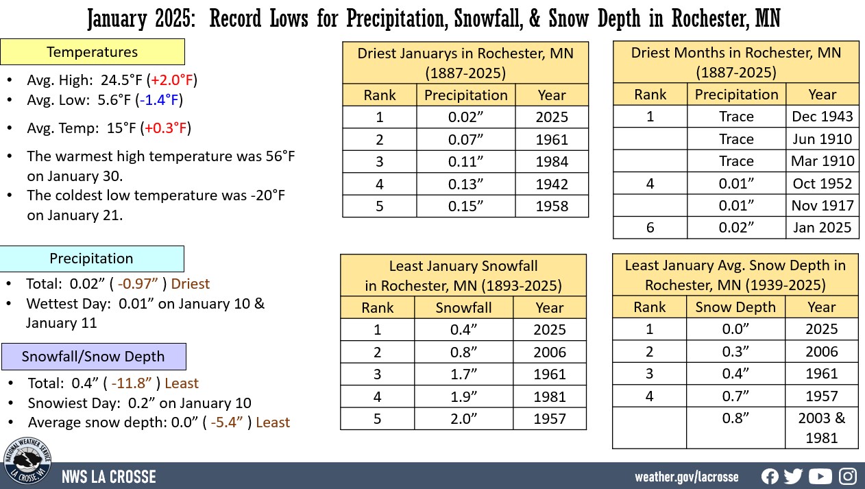
Rochester, MN
January 2025: Rochester MN Saw Highly Variable Temperatures and
a Record Lack of Precipitation, Snowfall, and Snow Depth
...January 2025 Highlights...
Temperatures - Slightly Warmer than Normal
- The average temperature at Rochester International Airport was 15°F. This was 0.3°F warmer than the 1991-2020 normal of 14.7°F.
- The average high temperature was 24.5°F. This was 2°F warmer than the 1981-2020 normal of 22.5°F.
- The average low temperature was 5.6°F. This was 1.4°F colder than the 1981-2020 normal of 7°F.
- The warmest temperature was 56°F on January 30 and the coldest temperature was -20°F on January 21. This 76°F difference was tied for the 6th greatest for January with 1919. The largest difference was 82°F in 1887 (the warmest temperature was 40°F and the coldest temperature was -42°F).
|
 |
The month was filled with temperature extremes...
- On January 19, the high temperature of -2° was the first time that a high temperature was below zero with no snow on the ground for Rochester. The previous record for the coldest high temperature with no snow on the ground was 1°F on January 21, 2013.
- On January 19, the low temperature of -12°F was the 5th coldest low temperature with no snow on the ground for Rochester. There have only been 44 days with a sub-zero low temperature with no snow on the ground.
- On January 20, the high temperature of -5° was only the second time that a high temperature was below zero with no snow on the ground for Rochester. The previous record for the coldest high temperature with no snow on the ground was -2°F on January 19, 2025.
- On January 20, the low temperature of -18°F was briefly the coldest low temperature with no snow on the ground for Rochester. This record would be broken on the next day.
- On January 21, the low temperature was -20°F. This is the coldest low temperature with no snow on the ground for Rochester.
- On January 21, the low temperature of -20°F ended a 1,090 day stretch with a low temperature -20°F or warmer. This was the 4th longest stretch. The last time there was a temperature colder than -20°F was on January 26, 2022 (-21°F). The longest stretch was 1,130 days from January 26, 2000 to January 29, 2004.
- On January 28, the high temperature was 51°F. This not only set a daily high temperature record (previous record was 49°F in 1931), but it also tied the 10th warmest January temperature with January 26, 1944 and January 7, 2003.
- On January 30, the high temperature was 56°F. This not set a daily high temperature record (previous record was 48°F in 1919), but it was also the 2nd warmest January temperature. The warmest January temperature was 58°F on January 25, 1944.
- Temperatures were 0°F or colder on 11 days. The long-term normal is 13 days. The least was 0 days in 1990 and 2006. The most was 27 days in 1977.
- Temperatures were 50°F or warmer on 2 days. This tied 1944, 2003, and 2012 for the second most in January. The most was 3 days in 1981.
- The daily temperature departure was plus or minus 10°F on 12 days. 7 were above normal (largest departure was 25°F on January 30) and 5 were below normal (largest departure was -25°F on January 20).
Daily temperature records began on July 1, 1886.
Precipitation - Driest January
- A total of 0.03" of precipitation fell at Rochester International Airport.
- This was 0.97" below the 1991-2020 normal of 0.99".
- This was the driest January. The previous record was 0.07" in 1961.
- The table below lists the ten driest Januarys in Rochester, MN.
Driest Januarys
in Rochester MN
1886-2025
Precipitation
Rank Total Year
---- ----- ----
1 0.02 inches 2025
2 0.07 inches 1961
3 0.11 inches 1984
4 0.13 inches 1942
5 0.15 inches 1958
6 0.17 inches 1962
7 0.18 inches 1957
8 0.19 inches 1913
9 0.20 inches 1948
10 0.23 inches 1981
- The greatest daily precipitation total was 0.01" on January 10 and January 11.
- Measurable rain fell on 2 days and trace amounts fell on 13 days.
- Daily precipitation records began on July 1, 1886.
Snowfall - Least January Snowfall
- A total of 0.4" of snowfall was recorded by the NWS official snowfall near Rochester International Airport.
- This was 11.8" below the 1991-2020 normal of 12.2".
- This was the least amount of snow in January.
- The previous record was 0.8" in 2006.
- The table below lists the ten least amounts of January snowfalls in Rochester MN.
Least Snowfall in January
in Rochester MN
1893-2025
Snowfall
Rank Total Year
---- ----- ----
1 0.4 inches 2025
2 0.8 inches 2006
3 1.7 inches 1961
4 1.9 inches 2013
5 2.0 inches 1957
6 2.1 inches 1974
2.1 inches 1958
8 2.2 inches 1944
9 2.3 inches 1948
10 2.5 inches 1962
- The greatest daily snowfall total was 0.2" on January 10.
- Measurable snow fell on 3 days and trace amounts fell on 12 days.
- Daily snow records began on January 1, 1939.
Snow Depth - Least
- The average snow depth was 0".
- This was 5.4" below the 1939-2025 long-term average of 5.4".
- This was the lowest January average. The previous record was 0.3" in 2006.
- The table below lists the ten least average snow amounts of January snowfalls in Rochester, MN.
Least Avg. January Snow Depth
in Rochester MN
1939-2025
Avg Snow Depth
Rank Total Year
---- ----- ----
1 0.0 inches 2025
2 0.3 inches 2006
3 0.4 inches 1961
4 0.7 inches 1957
5 0.8 inches 2003
0.8 inches 1981
7 1.0 inches 1995
8 1.1 inches 2002
9 1.4 inches 1964
1.4 inches 1960
1.4 inches 1959
- The greatest daily snow depth was a trace from January 11 through January 16.
- There were trace amounts of snow on the ground on 6 days, and no days with measurable snow. This was the first January that has occurred. Previous record was 26 days in 1981 and 2006.
- Daily snow depth records began on January 1, 1939.
...Records...
Daily...
- Record High (51°F) - Previous record was 49°F in 1931. Daily temperature records began on July 1, 1886.
Monthly...
- Driest (0.02") - Previous record was 0.07" in 1961. Daily precipitation records began on July 1, 1886. 6th driest month. Driest month since October 1952 (0.01” -4th driest month). Driest months were in March and June 1910 & December 1943 with a trace.
- Least snowfall (0.4 ") - Previous record was 0.8" in 2006. Daily snowfall records began on January 1, 1939.
- Least Average Snow Depth (0") - Previous record was 0.3" in 2006. Daily snow depth records began on January 1, 1939.
- First January with no days with measurable snow on the ground at 7 AM - Previous record was 26 days in 1981 and 2006. Daily snow depth records began on January 1, 1939.
...Looking ahead to February...
- The normal high temperature in Rochester starts off at 23°F on February 1st and warms to 32°F by the end of the month. The normal low temperature starts off at 7°F on the 1st and falls to 16°F by the end of the month. The warmest February temperature on record was 63°F on February 17, 1981, and the coldest was -35°F on February 2, 1996.
- The normal mean temperature for February is 18.7°F (2nd coldest month). Rochester’s warmest February occurred in 1931 with an average temperature of 32°F, and its coldest February occurred in 1936 with an average temperature of 0.5°F.
- The normal February precipitation is 1.02" (2nd driest month). The wettest February occurred in 2019 with 2.97" of precipitation and the driest February occurred in 1964 with just 0.04". The wettest February day occurred on February 20, 2014, when 1.12" of precipitation fell.
- The normal February snowfall is 10.7" (3rd snowiest month). The snowiest February occurred in 2019 with 40" of snow and the least snow was 0.2" in 1930 and 1954. The snowiest February day occurred on February 27, 1893, when 13.5" of snow fell.

