Temperatures:
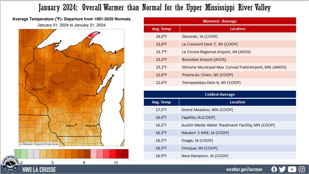
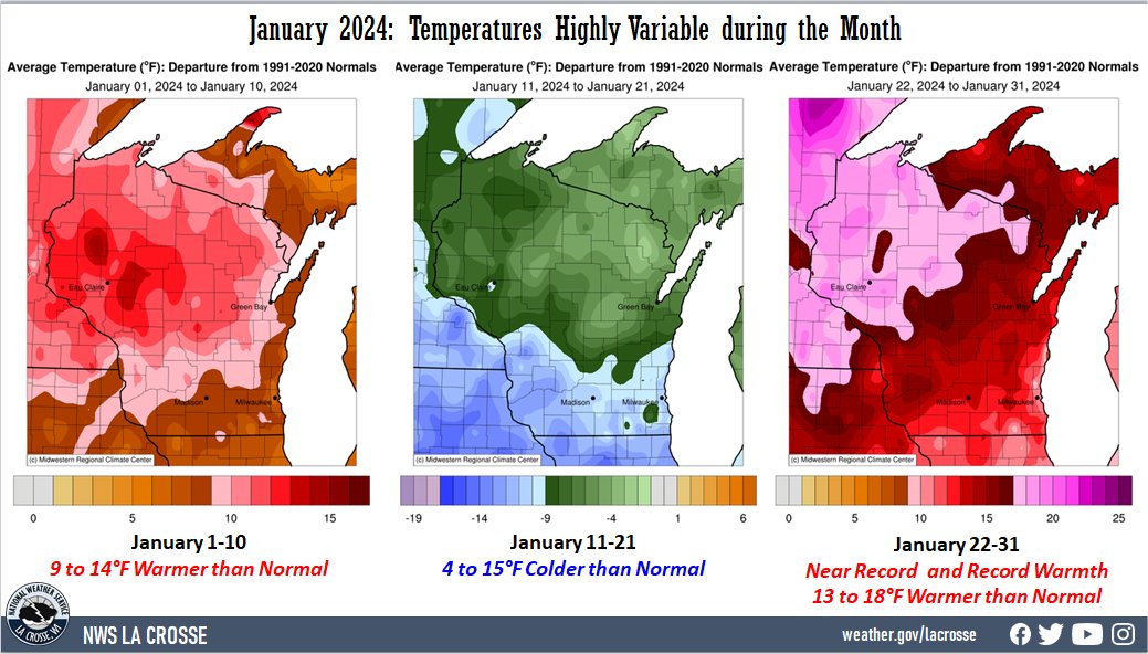
- During January 2024, temperatures were highly variable during the month. Temperatures were well above normal during the first and last 10 days and well below normal during the middle of the month. Overall, the month averaged warmer than normal (3-9°F) across the Upper Mississippi River Valley. The largest anomalies were north of Interstate 90. Average temperatures ranged from 17.5°F at Grand Meadow, MN (COOP) to 24°F at Decorah, IA (COOP).
- There was an 84°F difference between the warmest and coldest temperatures in the Upper Mississippi River Valley. The warmest temperature was 54°F at Austin Municipal Airport (AWOS) on January 31. Meanwhile, the coldest temperature was -30°F at Theilman, MN (COOP) on January 21.
|
 |
Precipitation:
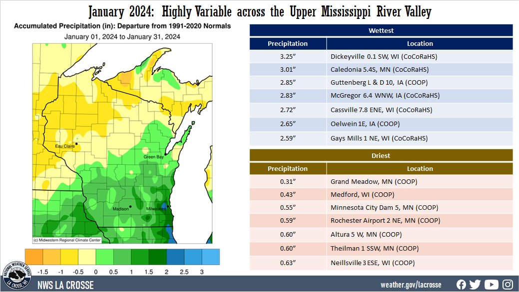
- Precipitation ranged from near normal to 2" wetter than normal in northeast Iowa and from southwest into central Wisconsin. Elsewhere precipitation ranged from near-normal to 1" drier than normal. Precipitation varied from 0.31" at Grand Meadow, MN (COOP) to 3.25" near Dickeyville, WI (CoCoRaHS). The highest one-day precipitation was 1.31" at Oelwein 1E, IA (COOP) from January 8 through January 9.
- Abnormally dry (D0) to moderate (D1) drought continues north of Interstate 90, and abnormally dry (D0) to extreme (D3) drought lingers elsewhere.
|
 |
Snowfall:
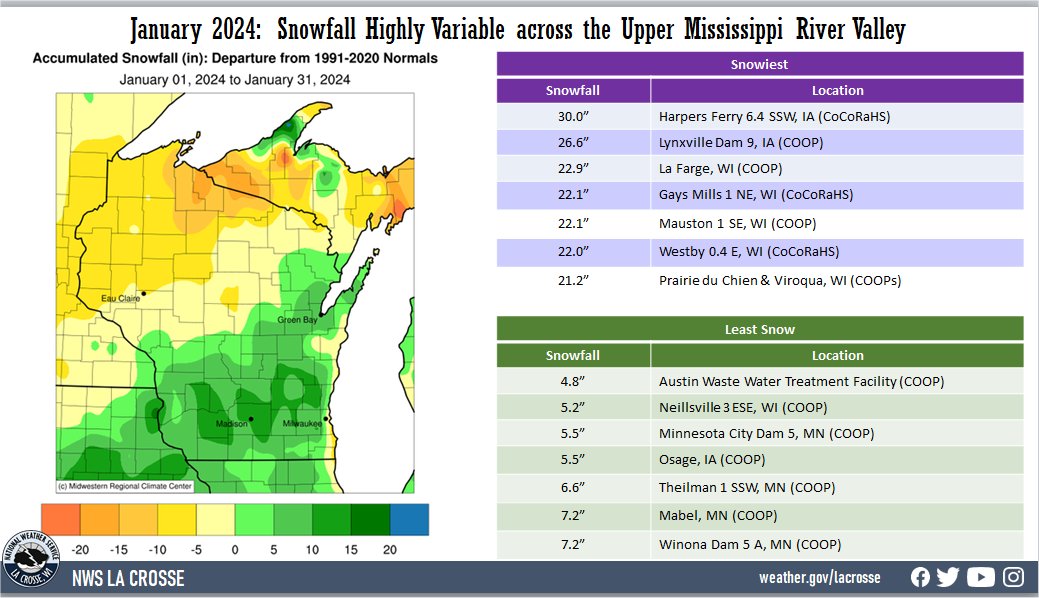
- Snowfall ranged from near normal to 20" above normal south of a Charles City, IA to Nekoosa, WI line. Elsewhere snowfall totals ranged from near normal to 10" below normal. Snowfall varied from 4.8" of snow at the Austin Waste Water Treatment Facility (COOP) to 30" near Harpers Ferry, IA (CoCoRaHS). The highest one-day snowfall was 12.5" at La Farge, WI (COOP) from January 12 to January 13.
|
 |
The information below details January 2024 temperatures, precipitation, and snowfall for La Crosse WI, and Rochester MN.
La Crosse, WI
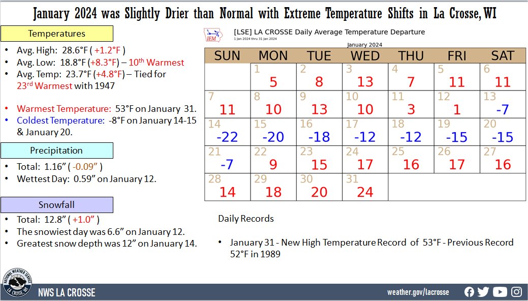
January 2024 was Slightly Drier than Normal with Extreme Temperature Shifts in La Crosse, WI
...January 2024 Highlights...
Temperatures - Tied for the 23rd Warmest January with 1947
-
During January 2024, the average temperature at La Crosse Regional Airport was 23.7°F. This was 4.8°F warmer than the 1991-2020 normal of 18.9°F. This was tied for the 23rd warmest January with 1947.
-
While the average temperature was warmer than normal, it does not tell the full story of the month. The month was full of extremes. There were 17 days where the temperatures ranged from 10°F to 24°F warmer than normal (January 3, January 5-10, and January 22-31) and 7 days where the temperatures ranged from 12°F to 22°F colder than normal (January 14-20).
|
 |
-
From January 1-10, temperatures were well above normal with an average temperature of 30.1°F. This was 10.3°F warmer than the 1991-2020 normal of 19.8°F. This was the 9th warmest and the warmest since 2012 (30.7°F). The warmest start to a year was in 1880 when the average temperature was 37.7°F.
-
In contrast, January 14-20 was much colder than normal. Temperatures averaged just 1.9°F which was 16.5°F colder than the 1991-2020 normal of 18.4°F. This was the 18th coldest for this period. This was the coldest for these dates since 2009 (0.4°F). The coldest temperature for this period was -15.2°F in 1994.
-
The area then returned to well above normal temperatures from January 22-31. Temperatures averaged 35.6°F which was 17°F warmer than the 1991-2020 normal of 18.6°F. This was the 2nd warmest for this period. Only 1944 was warmer with an average temperature of 36.7°F.
-
The average high temperature was 28.6°F. This was 1.2°F warmer than the 1991-2020 normal of 27.4°F.
-
The average low temperature was 18.8°F. This was 8.3°F warmer than the 1991-2020 normal of 10.5°F.
-
The highest temperature was 53°F on January 31.
-
The coldest high temperature was 2°F on January 14.
-
The warmest low temperature was 36°F on January 30.
-
The coldest low temperature was -8°F on January 14-15 and January 20.
-
Temperatures fell to 0°F or colder on 9 days. The long-term average (1873-2024) is 10 days.
​Precipitation - Slightly Drier than Normal
-
A total of 1.16 inches of precipitation fell. This is 0.09" drier than the 1991-2020 normal of 1.25".
-
The wettest day was on January 12 when 0.59" of precipitation fell.
-
Measurable precipitation fell on 7 days (22.6% of the month) and trace amounts fell on another 4 days (12.9% of the month).
Snowfall - Slightly Snowier than Normal
-
A total of 12.8" of snow was measured by the official NWS snow observer near the airport. This was 1" greater than the 1991-2020 normal of 11.8". All of this measurable snow fell from January 8 through January 13.
-
The greatest snow fell on January 12 when 6.6" of snow fell.
-
Measurable snow fell on 5 days (16.1% of the month) and trace amounts fell on another 4 days (12.9% of the month).
Snow Depth - Slightly Below Average
-
The average snow depth was 4.9 inches. This was 0.1" below the long-term average (1873-2024) of 5".
-
The greatest snow depth was 12" on January 14.
-
Measurable snow was on the ground for 23 days (74.2% of the month). There was 1 day with just a trace of snow of the ground (3.2% of the month) and no snow on 7 days (22.6% of the month).
...Records...
- Daily
- January 31 - New High Temperature Record 53°F - Previous Record 52°F in 1989
...Looking ahead to February...
- The normal high temperature in La Crosse starts off at 28°F on February 1st and warms to 38°F by the end of the month. The normal low temperature starts off at 10°F on the 1st and warms to 19°F by the end of the month. The warmest February temperature on record was 65°F on February 12, 1882, February 15, 1921, and February 19, 2017; and the coldest was -36°F on February 8, 1971.
- The normal mean temperature for February is 23.3°F. La Crosse’s warmest February occurred in 1878 with an average temperature of 36.7°F, and their coldest February occurred in 1875 with an average temperature of 3.9°F.
- The normal February precipitation is 1.19" (driest month). The wettest February occurred in 1922 with 4.04" of precipitation and the driest February occurred in 1969 with just 0.05". The wettest February day occurred on February 22, 1922, when 2.05 inches of precipitation fell.
- The normal February snowfall is 9.7" (3rd snowiest month). The snowiest February occurred in 2019 with 31.1" of snow and the least snow was 0.5" in 1954. The snowiest February day occurred on February 28, 1939, when 10.9" of snow fell.
Rochester
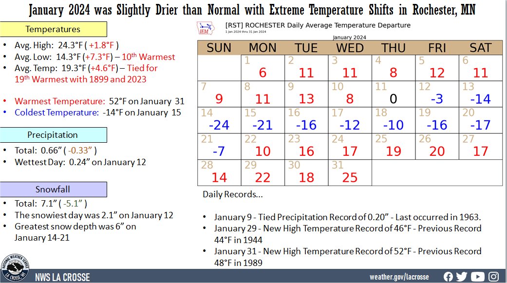
January 2024 was Drier than Normal with Extreme Temperature Shifts in Rochester, MN
...January 2024 Highlights...
Temperatures - Tied for 19th Warmest January with 1889 and 2023
-
During January 2024, the average temperature at Rochester International Airport was 19.3°F. This was 4.6°F warmer than the 1991-2020 normal of 14.7°F. This January was tied for the 19th warmest January with 1889 and 2023.
-
While the average temperature was warmer than normal, it does not tell the full story of the month. The month was full of extremes. There were 16 days where the temperatures were 11°F or warmer (January 2-3, January 5-6, January 8-9, and January 22-31) and 8 days where the temperatures were 10°F or colder than normal (January 13-20).
|
 |
-
From January 1-10, temperatures were well above normal with an average temperature of 25.6°F. This was 10.1°F warmer than the 1991-2020 normal of 15.5°F. This was the 13th warmest and the warmest since 2012 (30.7°F - warmest start to a year).
-
In contrast, January 13-20 was much colder than normal. Temperatures averaged just -2.2°F which was 16.5°F colder than the 1991-2020 normal of 14.3°F. This was tied with 1893 for the 8th coldest for this period. This was the coldest for these dates since 1994 (-14.1°F - coldest for this period).
-
The area then returned to well above normal temperatures from January 22-31. Temperatures averaged 32.6°F which was 18.2°F warmer than the 1991-2020 normal of 14.4°F. This was the 2nd warmest for this period. Only 1944 was warmer with an average temperature of 34.8°F.
-
The average high temperature was 24.3°F. This was 1.8°F warmer than the 1991-2020 normal of 22.5°F.
-
The average low temperature was 14.3°F. This was 7.3°F warmer than the 1991-2020 normal of 7°F. This was the 10th warmest.
-
The highest temperature was 52°F on January 31.
-
The coldest high temperature was -5°F on January 14.
-
The warmest low temperature was 32°F on January 25-26.
-
The coldest low temperature was -14°F on January 15.
Precipitation - Drier than Normal
-
A total of 0.66" of precipitation fell. This is 0.33" drier than the 1991-2020 normal of 0.99".
-
The wettest day was on January 12 when 0.24" of precipitation fell.
-
Measurable precipitation fell on 8 days (25.8% of the month) and trace amounts fell on another 4 days (12.9% of the month).
Snowfall - Below Normal
-
A total of 7.1" of snow was measured by the official NWS snow observer near the airport. This was 5.1" lower than the 1991-2020 normal of 12.2 inches.
-
The greatest snow fell on January 12 when 2.1" of snow fell.
-
Measurable snow fell on 7 days (22.6% of the month) and trace amounts fell on another 4 days (12.9% of the month).
Snow Depth - Below Normal
-
The average snow depth was 2.9". This was 2.6" below the long-term average (1886-2024) of 5.5".
-
The greatest snow depth was 6" on January 14-21.
-
Measurable snow was on the ground for 21 days (67.7% of the month). There was no snow on 10 days (32.3% of the month).
...Records...
- Daily
- January 9 - Tied Precipitation Record of 0.20" - Last occurred in 1963.
- January 29 - New High Temperature Record of 46°F - Previous Record 44°F in 1944
- January 31 - New High Temperature Record of 52°F - Previous Record 48°F in 1989
...Looking ahead to February...
- The normal high temperature in Rochester starts off at 23°F on February 1st and warms to 32°F by the end of the month. The normal low temperature starts off at 7°F on the 1st and falls to 16°F by the end of the month. The warmest February temperature on record was 63°F on February 17, 1981, and the coldest was -35°F on February 2, 1996.
- The normal mean temperature for February is 18.7°F (2nd coldest month). Rochester’s warmest February occurred in 1931 with an average temperature of 32°F, and its coldest February occurred in 1936 with an average temperature of 0.5°F.
- The normal February precipitation is 1.02" (2nd driest month). The wettest February occurred in 2019 with 2.97" of precipitation and the driest February occurred in 1964 with just 0.04". The wettest February day occurred on February 20, 2014, when 1.12" of precipitation fell.
- The normal February snowfall is 10.7" (3rd snowiest month). The snowiest February occurred in 2019 with 40" of snow and the least snow was 0.2" in 1930 and 1954. The snowiest February day occurred on February 27, 1893, when 13.5" of snow fell.


 Weather Story
 Weather Map
 Local Radar