Temperatures:
|
During January 2023, monthly temperatures ranged from 18.2°F at Dodge Center Airport, MN (AWOS) to 26.2°F at Boscobel Airport, WI (ASOS). These temperatures were 5 to 9°F warmer than normal. The warmest temperature was 45°F at Boscobel Airport, WI (ASOS) on the 11th; New Hampton, IA (COOP) on the 15th; and Preston, MN (COOP) on the 1st. The coldest temperature was -25°F at Black River Falls, WI (RAWS); southwest of Elkader, IA (COOP); and near Theilman, MN (COOP) on the 31st.
|
 |
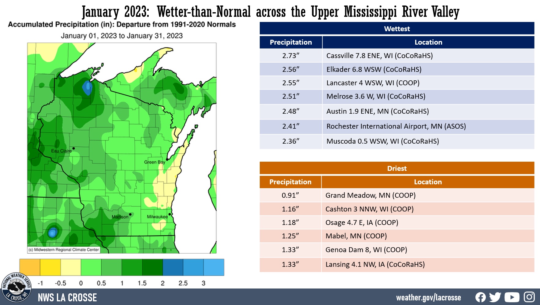
Precipitation:
|
Like December 2022, January 2023 was wetter-than-normal across much of the Upper Mississippi River Valley. precipitation anomalies ranged from near-normal to 2” wetter-than-normal. Precipitation totals ranged from 0.91” at Grand Meadow, MN (COOP) to 2.73” near Cassville, WI (CoCoRaHS). The greatest 1-day precipitation was 1.15" near Altura, MN (COOP). This precipitation fell from 7 AM on January 3 to 7 AM on January 4.
|
 |
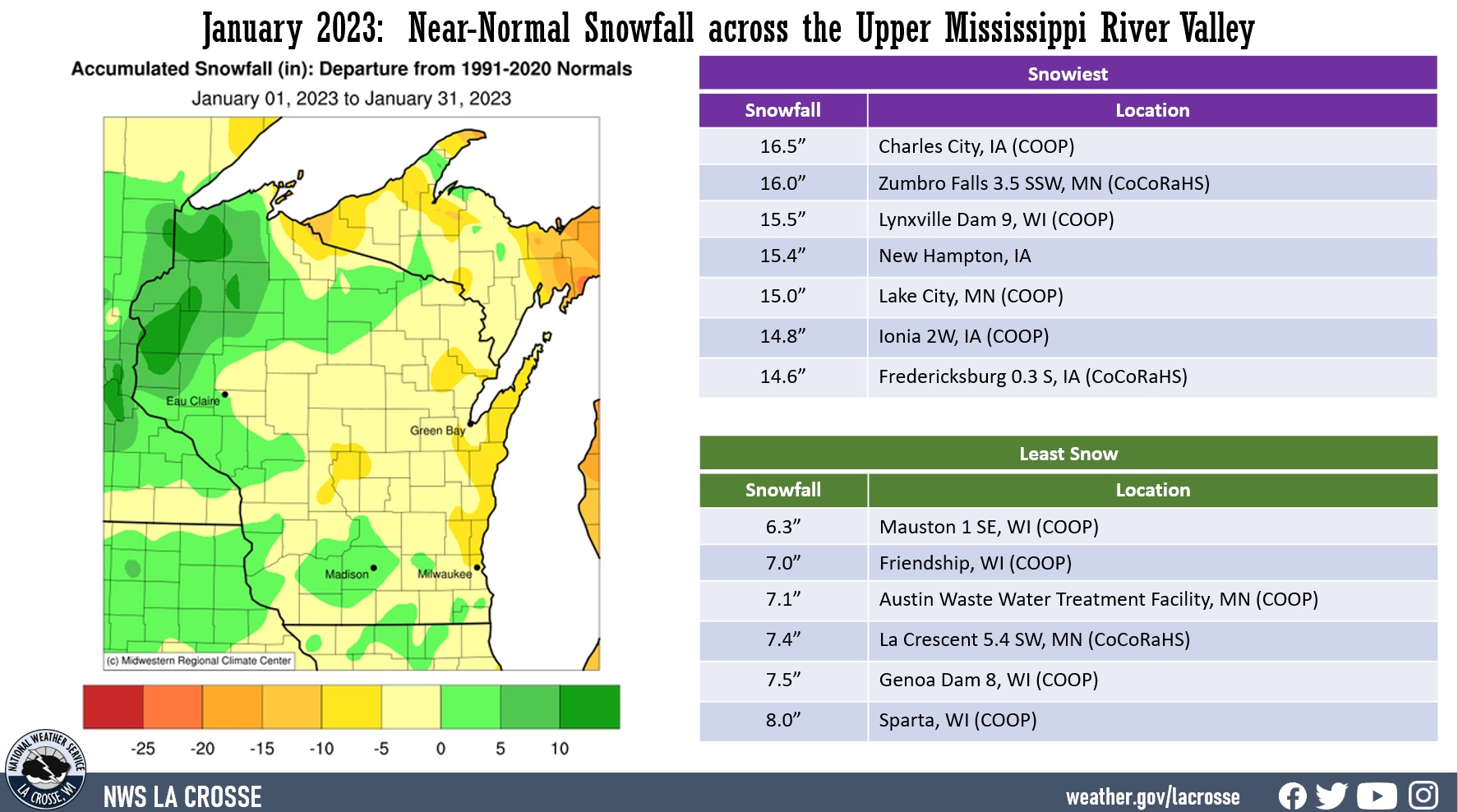
Snowfall:
|
Snowfall was near-normal for January 2023. Snowfall ranged from 6.3” near Mauston, WI (COOP) to 16.5” at Charles City, IA (COOP). The greatest 1-day snowfall was 9.1" at Charles City, IA (COOP). This snow fell from 7 AM on January 18 to 7 AM on January 19.
|
 |
Below are December 2022 climate summaries for La Crosse, WI, and Rochester, MN.
La Crosse, WI
January 2023 was Warmer and Wetter than Normal in La Crosse, WII
Temperatures - 14th Warmest January
- During January 2023, the average temperature at La Crosse Regional Airport was 24.4°F. This was 5.5°F warmer than 1991-2020 normal of 18.9°F. This was the 14th warmest January and the warmest January since 2006 (average temperature 31.1°F - 2nd warmest). The warmest January occurred in 1880 when the average temperature was 32.0°F.
- The average high temperature was 29.8°F. This was 2.4°F warmer than 1991-2020 normal of 27.4°F. This was the warmest January average since 2021 (30.3°F).
- The average low temperature was 18.9°F. This was 8.4°F warmer than 1991-2020 normal of 10.5°F. This was the 9th warmest in January and the warmest since 2006 (24.1°F - warmest ever).
|
 |
- The warmest temperature was 41°F on January 15.
- The coldest temperature was -12°F on January 31.
- The low temperature was at or below 0°F on just 2 days (30th and 31st). The long-term average (1873-2023) is 10 days. There have only been 13 Januarys that have had that few. 5 of these had none (1891, 1923, 1990, 2002, and 2006).
- The first half of January was tied with 2019 for the 7th warmest with an average temperature of 27.6°F which was 8.3°F above the 1991-2020 normal of 19.3°F. The warmest first half of January occurred in 1880 (34.3°F).
- January 2023 (24.4°F) was warmer than December 2022 (21.5°F). This was the first time that a January has been warmer than a December since 2016-17. This was the 28th time that this has occurred since 1872-73. January 2023 was 2.9°F warmer than December 2022. This was the 14th largest temperature difference when this occurred. It was the largest difference since 2005-06 (January 2006 was 11.4°F warmer than December 2005). The largest temperature difference where January was warmer than December occurred in 1989-90. During that winter, January 1990 (28.1°F) was 16°F warmer than December 1989 (12.1°F).
Precipitation - 17th Wettest January
- A total of 2.17" of precipitation fell. This is 0.92" wetter than 1991-2020 normal of 1.25". This made it the 17th wettest January and the wettest since 2017 (2.69" - 6th wettest). The wettest January occurred in 1886 when 3.44" of precipitation fell.
- The wettest day was 0.91" on January 3. Tied for the 9th wettest January day with January 3, 1906. The wettest January day was 1.67" on January 5, 1946.
- There were 13 days with measurable precipitation which is 4 more days than the long-term average (1873-2023).
- There were another 3 days with just a trace of precipitation.
- This was the third month in a row to see above-normal precipitation.
Snowfall - Slightly Less than Normal
- The official NWS snow observer near La Crosse Regional Airport reported 10.2" of snow. This was 1.6" below 1991-2020 normal of 11.8". This was the third January in a row to see below-normal snowfall.
- The snowiest day was 5" on January 19.
Snow Depth - Below Normal
- The average snow depth was 3.7". This was 1.3 inches below the long-term average (1873-2023) of 5".
- The greatest snow depth was 6" on January 28-31.
Clouds
- In January, there were 16 cloudy days. While it seemed very cloudy, it was still 1 day below the average of 17 days. It probably seemed much cloudier than normal because we had a 10-day stretch of cloudy days from January 16 through January 25. January is the 3rd cloudiest month. The only other months with more are December with 19 days and November with 18 days.
...Records...
...Looking ahead to February...
- The normal high temperature in La Crosse starts off at 28°F on February 1st and warms to 38°F by the end of the month. The normal low temperature starts off at 10°F on the 1st and warms to 19°F by the end of the month. The warmest February temperature on record is 65°F on February 12, 1882, February 15, 1921, and February 19, 2017; and the coldest is -36°F on February 8, 1971.
- The normal mean temperature for February is 23.3°F. La Crosse’s warmest February occurred in 1878 with an average temperature of 36.7°F, and their coldest February occurred in 1875 with an average temperature of 3.9°F.
- The normal February precipitation is 1.19" (driest month). The wettest February occurred in 1922 with 4.04" of precipitation and the driest February occurred in 1969 with just 0.05". The wettest February day occurred on February 22, 1922, when 2.05" of precipitation fell.
- The normal February snowfall is 9.7" (3rd snowiest month). The snowiest February occurred in 2019 with 31.1" of snow and the least snow was 0.5" in 1954. The snowiest February day occurred on February 28, 1939, when 10.9" of snow fell.
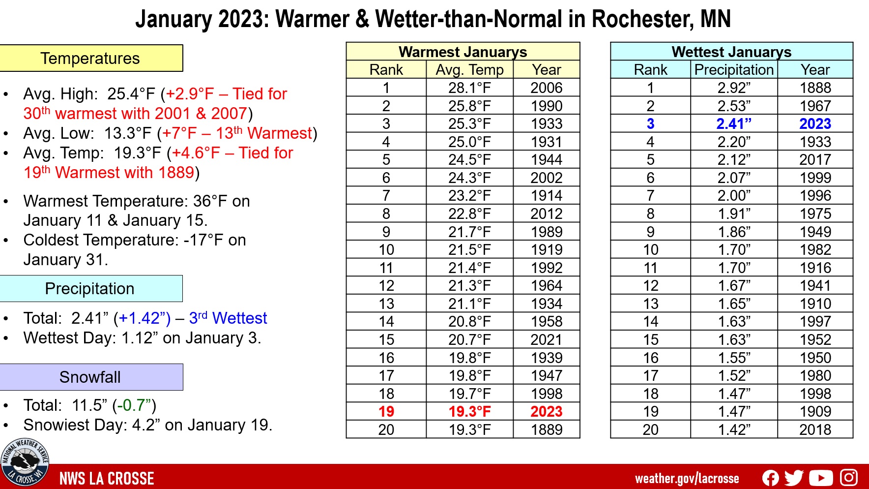
Rochester, MN
January 2023 was Warmer and Wetter than Normal in Rochester, MN
Temperatures - Warmer than Normal
- During January 2023, the average temperature at Rochester International Airport was 19.3°F. This was 4.6°F warmer than 1991-2020 normal of 14.7°F.
- The average high temperature was 25.4°F. This was 2.9°F warmer than 1991-2020 normal of 22.5°F.
- The average low temperature was 13.3°F. This was 7°F warmer than 1991-2020 normal of 4.6°F. This was the 25th warmest in January.
- The warmest temperature was 36°F on January 11.
- The coldest temperature was -17°F on January 31.
|
|
 |
- The low temperature was at or below 0°F on just 5 days. The long-term average (1886-2023) is 13 days. There have only been 14 Januarys that have had that few. Two of these had none (1990 and 2006).
- The first half of January was 4th warmest with an average temperature of 25.8°F which was 10.7°F above 1991-2020 normal of 15.1°F. The warmest first half of January occurred in 2006 (29.1°F).
- January 2023 (19.3°F) was warmer than December 2022 (17.2°F). This was the first time that a January has been warmer than a December since 2016-17. This was the 17th time that this has occurred since 1885-86. January 2023 was 2.1°F warmer than December 2022. This was tied with 1933-34 for the 13th largest temperature difference when this occurred. It was the largest difference since 2005-06 (January 2006 was 10.9°F warmer than December 2005). The largest temperature difference where January was warmer than December occurred in 1989-90. During that winter, January 1990 (25.8°F) was 15.8°F warmer than December 1989 (10°F).
Precipitation - 3rd Wettest January
- A total of 2.41" of precipitation fell. This is 1.42" wetter than the 1991-2020 normal of 0.99". This made it the 3rd wettest January and the wettest since 1967 (2.53" - 2nd wettest). The wettest January occurred in 1888 when 2.92" of precipitation fell.
- The wettest day was 1.12" on January 3. This was the 5th wettest January day. The wettest January day was 1.50" on January 6, 1888.
- There were 9 days with measurable precipitation which was 1 more day than the long-term average (1873-2023).
- There were another 8 days with just a trace of precipitation.
Snowfall...Slightly Less than Normal
- The official NWS snow observer near Rochester International Airport reported 11.5" of snow. This was 0.7" below 1991-2020 normal of 12.2". This was the third January in a row to see below-normal snowfall.
- The snowiest day was 4.2" on January 19.
Snow Depth...Above Normal
- The average snow depth was 5.9". This was 0.4" above the long-term average (1873-2023) of 5.9".
- The greatest snow depth was 8" on January 20-22.
Clouds
- In January, there were 16 cloudy days. While it seemed very cloudy, it was still 1 day below the average of 17 days. It probably seemed much cloudier than normal because we had a 7-day stretch of cloudy days from January 16 through January 22. January is the 3rd cloudiest month. The only other months with more are November and December with 19 days.
...Records...
Daily Precipitation...
- January 3 - 1.12" - Previous Record 0.77" in 1973
...Looking ahead to February...
- The normal high temperature in Rochester starts off at 23°F on February 1st and warms to 32°F by the end of the month. The normal low temperature starts off at 7°F on the 1st and falls to 16°F by the end of the month. The warmest February temperature on record is 63°F on February 17, 1981, and the coldest is -35°F on February 2, 1996.
- The normal mean temperature for February is 18.7°F (2nd coldest month). Rochester’s warmest February occurred in 1931 with an average temperature of 32°F, and its coldest February occurred in 1936 with an average temperature of 0.5°F.
- The normal February precipitation is 1.02" (2nd driest month). The wettest February occurred in 2019 with 2.97" of precipitation and the driest February occurred in 1964 with just 0.04". The wettest February day occurred on February 20, 2014, when 1.12" of precipitation fell.
- The normal February snowfall is 10.7" (3rd snowiest month). The snowiest February occurred in 2019 with 40" of snow and the least snow was 0.2" in 1930 and 1954. The snowiest February day occurred on February 27, 1893, when 13.5" of snow fell.


 Weather Story
 Weather Map
 Local Radar