January 2022 Climate Summary for the Upper Mississippi River Valley
Temperature Summary
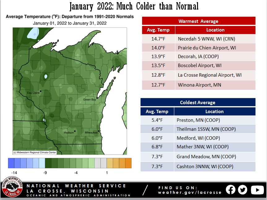
- During January 2022, average temperatures in the Upper Mississippi River Valley ranged from 5°F to 10°F colder than normal. The average temperatures ranged from 5.4°F at Preston, MN (COOP observer) to 14.7°F near Necedah, WI (Climate Reference Network). January average temperatures typically range from 10°F to 20°F. For most locations, this was the coldest January since 2014 and the coldest month since February 2021.
- The warmest temperature was 46°F at Boscobel Airport (ASOS) on January 12. Meanwhile, the coldest temperature was -36°F at Preston, MN on January 26.
|
 |
- There were periodic Wind Chill Advisories (11 of them) and Wind Chill Warnings (3 of them) during the month. The coldest wind chill at La Crosse, WI was -35°F at 8:53 AM on January 26. Meanwhile, the coldest wind chill at Rochester, MN was -42°F at 6:54 AM on January 26.
Precipitation Summary
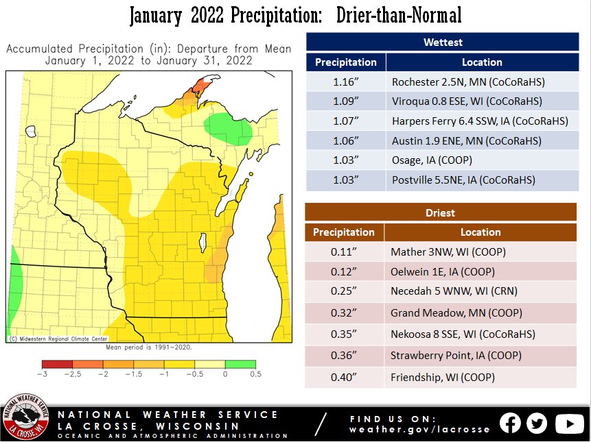
- Precipitation was drier than normal across the Upper Mississippi River Valley. Precipitation departures were up to 1" drier-than-normal across the region. Precipitation totals ranged from 0.11" near Mather, WI (COOP observer) to 1.16" near Rochester, MN (CoCoRaHS observer). January precipitation typically ranges from 0.75 to 1.5".
- For most locations, the wettest day was on January 14. The wettest location on this day was near Austin, MN (0.71" from a CoCoRaHS observer).
|
 |
Snowfall Summary
- January 2022 snowfall was below normal across the Upper Mississippi River Valley. Snow totals ranged from 2.8" near Oxford, WI (CoCoRaHS observer) to 12" at the Austin, MN Waste Water Treatment Facility (COOP Observer) and near New Hampton, IA (CoCoRaHS observer). Snowfall typically ranges from 10 to 15".
- While snowfall averaged below normal, it did not mean that we did not see some impactful winter weather. There were 5 Winter Weather Advisories, 1 Winter Storm Warning (January 13-14), and 1 Blizzard Warning (January 4-5).
- The greatest 1-day snowfall was 8" near Nora Springs, IA (CoCoRaHS observer) on January 14.
|
 |
Below are the January 2022 climate summaries for La Crosse, WI, and Rochester, MN.
La Crosse, WI Climate Summary
January 2022 was Colder & Drier than Normal in La Crosse, WI
...January 2022 Highlights...
|
Temperatures...
- The average temperature was 12.8°F. This was 6.1°F colder than 1991-2020 normal of 18.9°F.
- Coldest January since 2014 (9.4°F - tied for 24th coldest with 1920).
- This was the first month to be colder than normal since February 2021.
- This was the coldest month since February 2021. The average temperature was the same as this month.
- The average high temperature was 23.3°F. This was 4.1°F colder than 1991-2020 normal of 27.4°F.
|
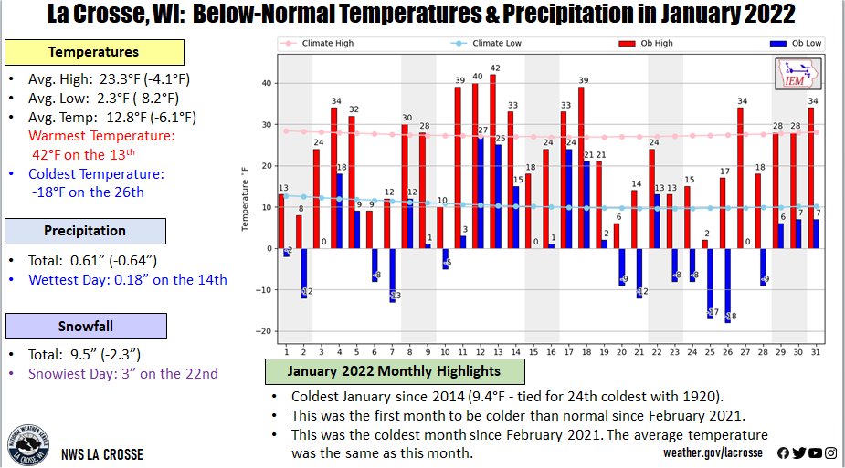 |
- The average low temperature was 2.3°F. This was 8.2°F colder than 1991-2020 normal of 16.5°F.
Precipitation...
- A total of 0.61" of precipitation fell. This was 0.64" drier than the 1991-2020 normal of 1.25".
- Driest January since 2006 (0.47" - tied with 1925 for 21st driest).
- Driest month since December 2020 (0.36" - tied with 2002 for the 11th driest)
- The wettest day was 0.18" on January 14.
Snowfall...
- A total of 9.5" of snow fell. Which was 2.3 inches below the 1991-2020 normal of 11.8".
- The snowiest day was 3 inches on January 22.
Snow Depth...
- The average snow depth was 6.6". This was 1.6" greater than the long-term average of 5". This was the greatest January average since 2014 (9.4" - 19th greatest).
- The greatest snow depth was 9" from January 24 through January 30.
- The least snow depth was 4 inches on January 14, and from January 19 through January 21.
...Records...
...Looking Ahead to February...
- The normal high temperature in La Crosse starts off at 28°F on February 1st and warms to 38°F by the end of the month. The normal low temperature starts off at 10°F on the 1st and rises to 19°F by the end of the month. The warmest February temperature on record is 65°F on February 12, 1882, February 15, 1921, and February 19, 2017; and the coldest is -36°F on February 8, 1971.
- The normal mean temperature for the month is 23.3°F. La Crosse’s warmest February occurred in 1878 with an average temperature of 36.7°F, and their coldest February occurred in 1875 with an average temperature of 3.9°F.
- The normal February precipitation is 1.19" (driest month). The wettest February occurred in 1922 with 4.04" of precipitation and the driest February occurred in 1969 with just 0.05". The wettest February day occurred on February 22, 1922, when 2.05" of precipitation fell.
- The normal February snowfall is 9.7" (3rd snowiest month). The snowiest February occurred in 2019 with 31.1" of snow and the least snow was 0.5" in 1954. The snowiest February day occurred on February 28, 1939, when 10.9" of snow fell.
Rochester, MN Climate Summary
January 2022 was Colder & Drier than Normal in Rochester, MN
...January 2022 Highlights...
|
Temperatures...
- The average temperature was 9.4°F. This was 5.3°F colder than 1991-2020 normal of 14.7°F.
- Coldest January since 2014 (6.5°F - tied with 1972 for the 20th coldest January).
- This was the first month to be colder than normal since February 2021.
- This was the coldest month since February 2021 (8.3°F).
- The average high temperature was 18.8°F. This was 3.7°F colder than 1991-2020 normal of 22.5°F.
|
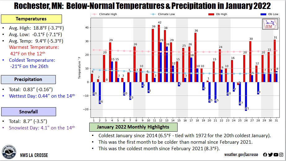 |
- The average low temperature was -0.1°F. This was 7.1°F colder than 1991-2020 normal of 7°F.
Precipitation...
- A total of 0.83" of precipitation fell. This was 0.16" drier than 1991-2020 normal of 0.99".
- Driest January since 2016 (0.75").
- Driest month since April 2021 (0.81").
- The wettest day was 0.44 inches on January 14.
Snowfall...
- A total of 8.7 inches of snow fell. This was 3.5" below the 1991-2020 normal of 12.2".
- This was the least amount of snow in January since 2016 (5.7").
- The snowiest day was 4.1" on January 14.
Snow Depth...
- The average snow depth was 3.3". This was 2.2" lower than the long-term average of 5.5".
- Greatest January average since 2014 (9.4" - 19th greatest).
- The greatest snow depth was 6" from January 23 through January 28.
- The least snow depth was 0" on January 14.
...Records...
...Looking Ahead to February...
- The normal high temperature in Rochester starts off at 23°F on February 1st and warms to 32°F by the end of the month. The normal low temperature starts off at 7°F on the 1st and rises to 16°F by the end of the month. The warmest February temperature on record is 63°F on February 17, 1981, and the coldest is -35°F on February 2, 1996.
- The normal mean temperature for the month is 18.7°F (2nd coldest month). Rochester’s warmest February occurred in 1931 with an average temperature of 32°F, and its coldest February occurred in 1936 with an average temperature of 0.5°F.
- The normal February precipitation is 1.02" (2nd driest month). The wettest February occurred in 2019 with 2.97" of precipitation and the driest February occurred in 1964 with just 0.04". The wettest February day occurred on February 20, 2014, when 1.12" of precipitation fell.
- The normal February snowfall is 10.7" (3rd snowiest month). The snowiest February occurred in 2019 with 40" of snow and the least snow was 0.2" in 1930 and 1954. The snowiest February day occurred on February 27, 1893, when 13.5" of snow fell.

