Overview
|
A slow moving storm system brought a mix of rain, freezing rain, sleet, and finally snow to the area beginning Monday January 2 and lasting into Thursday January 5. The most impact occurred Monday night into Tuesday morning when freezing rain brought ice accumulations up to around 1/4 of an inch across southeast Minnesota into western Wisconsin. Temperatures warmed over most of the area for a change over to rain Tuesday, followed by colder air moving in Wednesday and Thursday with light snow accumulations up to about 3 inches. |
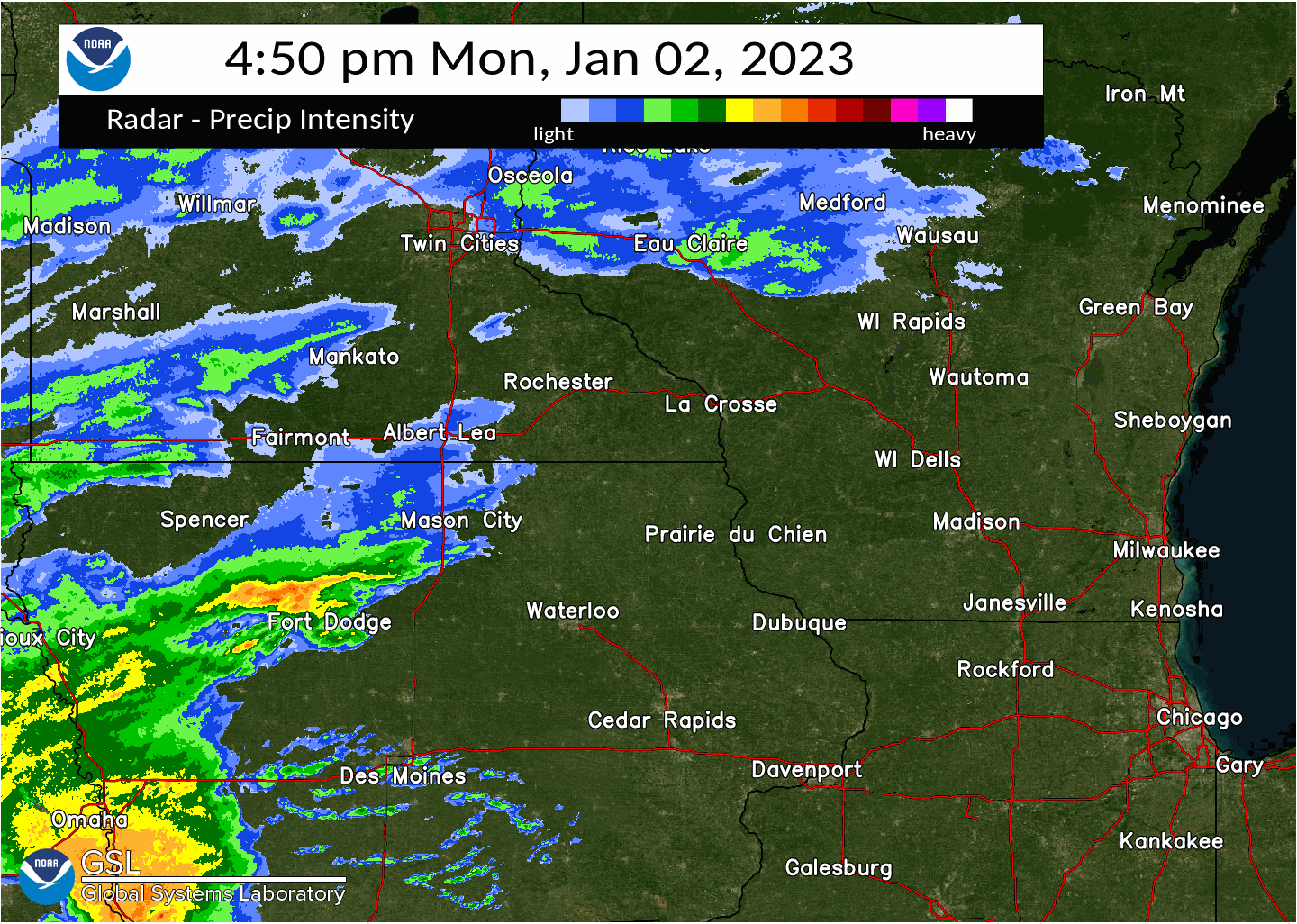 Initial period of the storm when a wintry mix and icing occurred Monday night and Tuesday Morning Jan 3 2023. |
Ice
PRELIMINARY LOCAL STORM REPORT...SUMMARY
NATIONAL WEATHER SERVICE LA CROSSE WI
349 PM CST SAT JAN 7 2023

..TIME...   ...EVENT...      ...CITY LOCATION...     ...LAT.LON...
..DATE...   ....MAG....      ..COUNTY LOCATION..ST.. ...SOURCE....
            ..REMARKS..

0857 AM     FREEZING RAIN    3 WNW STEVENSTOWN       44.06N 91.22W
01/03/2023  M0.30 INCH       TREMPEALEAU        WI   TRAINED SPOTTER

            WINTRY MIX OF SLEET, SNOW, AND FREEZING
            RAIN.

0857 AM     FREEZING RAIN    3 WNW STEVENSTOWN       44.06N 91.22W
01/03/2023  M0.30 INCH       TREMPEALEAU        WI   TRAINED SPOTTER

            WINTRY MIX OF SLEET, SNOW, AND FREEZING
            RAIN.

0812 AM     FREEZING RAIN    2 E LA CROSSE           43.82N 91.19W
01/03/2023  M0.08 INCH       LA CROSSE          WI   OFFICIAL NWS OBS


0900 AM     FREEZING RAIN    2 NNW WILSON            43.99N 91.71W
01/03/2023  M0.25 INCH       WINONA             MN   TRAINED SPOTTER

            WINTRY MIX OF ICE AND SLEET ON DRIVE. LESS
            ON TREES. RAINING NOW.

0900 AM     FREEZING RAIN    2 SSE DAKOTA            43.88N 91.34W
01/03/2023  M0.20 INCH       WINONA             MN   NWS EMPLOYEE

            ASYMMETRICAL ICE ACCUMULATION ON DOWEL,
            GREATER IN THE VERTICAL.

0900 AM     FREEZING RAIN    2 NNW WILSON            43.99N 91.71W
01/03/2023  M0.25 INCH       WINONA             MN   TRAINED SPOTTER

            WINTRY MIX OF ICE AND SLEET ON DRIVE. LESS
            ON TREES. RAINING NOW.

1200 PM     FREEZING RAIN    LEWISTON                43.98N 91.87W
01/03/2023  E0.20 INCH       WINONA             MN   PUBLIC

            PUBLIC REPORT VIA KAAL TV.

0832 AM     FREEZING RAIN    BYRON                   44.03N 92.64W
01/03/2023  M0.25 INCH       OLMSTED            MN   BROADCAST MEDIA


0945 AM     FREEZING RAIN    2 NNE ROCHESTER         44.04N 92.46W
01/03/2023  M0.19 INCH       OLMSTED            MN   TRAINED SPOTTER

            SEVEN MEASUREMENTS - SOME SLEET AND SNOW
            MIXED IN.

1200 PM     FREEZING RAIN    3 NNW ROCHESTER         44.05N 92.51W
01/03/2023  E0.25 INCH       OLMSTED            MN   PUBLIC

            PUBLIC REPORT VIA KAAL TV.

1204 PM     FREEZING RAIN    1 SSW ORONOCO           44.15N 92.54W
01/03/2023  E0.15 INCH       OLMSTED            MN   PUBLIC


0828 AM     FREEZING RAIN    3 WSW LA CRESCENT       43.81N 91.37W
01/03/2023  M0.05 INCH       HOUSTON            MN   BROADCAST MEDIA
Snow
...SNOWFALL TOTALS...

Location                     Amount    Time/Date       Lat/Lon

...Iowa...

...Allamakee County...
Postville 5.5 NE             1.5 in    0700 AM 01/05   43.14N/91.49W
Harpers Ferry 6.4 SSW        1.1 in    0700 AM 01/05   43.11N/91.20W

...Chickasaw County...
New Hampton 0.4 SW           0.7 in    0700 AM 01/05   43.06N/92.32W
Fredericksburg 0.3 S         0.5 in    0800 AM 01/05   42.96N/92.20W

...Clayton County...
Strawberry Point             1.2 in    0700 AM 01/05   42.69N/91.53W
McGregor 6.4 WNW             1.0 in    0716 AM 01/05   43.07N/91.29W
Elkader 6SSW                 0.7 in    0700 AM 01/05   42.78N/91.45W
Elkader 6.8 WSW              0.6 in    0600 AM 01/05   42.81N/91.52W

...Fayette County...
Oelwein 1 E                  0.8 in    0630 AM 01/05   42.68N/91.88W
Fayette                      0.8 in    0700 AM 01/05   42.88N/91.83W

...Floyd County...
Nora Springs 2.4 SSE         1.0 in    0700 AM 01/05   43.11N/92.99W

...Mitchell County...
Osage                        0.4 in    0800 AM 01/05   43.28N/92.81W
St Ansgar                    0.3 in    0630 AM 01/05   43.38N/92.92W
Osage                        0.2 in    0745 AM 01/04   43.28N/92.81W

...Winneshiek County...
7 ENE Decorah                1.0 in    0834 AM 01/05   43.34N/91.64W

...Minnesota...

...Dodge County...
Mantorville 1.9 ESE          2.4 in    0700 AM 01/04   44.05N/92.72W
Hayfield 0.3 SSE             1.2 in    0400 AM 01/04   43.89N/92.85W
Mantorville 1.9 ESE          1.0 in    0700 AM 01/05   44.05N/92.72W
Hayfield 0.3 SSE             0.9 in    0400 AM 01/05   43.89N/92.85W

...Fillmore County...
Wykoff 3.1 NW                1.8 in    0700 AM 01/05   43.74N/92.31W
Chatfield 9.0 ESE            1.2 in    0700 AM 01/05   43.79N/92.03W
Mabel                        1.0 in    0640 AM 01/05   43.52N/91.76W
Wykoff 3.1 NW                0.2 in    0700 AM 01/04   43.74N/92.31W

...Houston County...
1 ENE Mound Prairie          1.6 in    0700 AM 01/05   43.79N/91.42W
Hokah 4 NW                   1.6 in    0700 AM 01/05   43.80N/91.43W
3 WSW La Crescent            1.2 in    0441 AM 01/05   43.81N/91.37W
Caledonia                    1.0 in    0800 AM 01/05   43.63N/91.50W

...Mower County...
Grand Meadow                 1.0 in    0530 AM 01/05   43.71N/92.56W
Waltham 2.0 SE               1.0 in    0800 AM 01/05   43.80N/92.85W
Austin 2.4 W                 0.5 in    0710 AM 01/05   43.67N/93.02W
Austin 2.4 W                 0.3 in    0700 AM 01/04   43.67N/93.02W
Austin Waste Water Treatment 0.2 in    0700 AM 01/04   43.65N/92.97W

...Olmsted County...
Elgin 2SSW                   3.0 in    0700 AM 01/05   44.10N/92.27W
Oronoco 3.3 ESE              2.6 in    0700 AM 01/04   44.14N/92.48W
1 SSW Oronoco                2.5 in    1135 AM 01/04   44.15N/92.54W
Rochester 5.7 N              2.3 in    0740 AM 01/05   44.10N/92.46W
2 NE Rochester               2.0 in    0600 AM 01/04   44.04N/92.44W
Stewartville 4.3 E           2.0 in    0430 AM 01/05   43.86N/92.40W
2 NE Rochester               2.0 in    0600 AM 01/05   44.04N/92.44W
Rochester 5.7 N              1.5 in    0700 AM 01/04   44.10N/92.46W
Rochester 4.7 N              1.5 in    0700 AM 01/04   44.08N/92.48W
2 NNW Rochester              1.5 in    0800 AM 01/04   44.05N/92.49W
Oronoco 3.3 ESE              1.5 in    0700 AM 01/05   44.14N/92.48W
Rochester 4.7 N              1.3 in    0700 AM 01/05   44.08N/92.48W
2 NNE Rochester              1.2 in    0726 AM 01/04   44.04N/92.46W
Rochester 1.5 WSW            1.0 in    0600 AM 01/05   44.00N/92.50W
2 NNW Rochester              1.0 in    0600 AM 01/05   44.05N/92.49W
Rochester AP 2NE             0.9 in    0700 AM 01/04   43.93N/92.48W
Elba 4.7 SW                  0.9 in    1030 PM 01/04   44.04N/92.09W
Rochester AP 2NE             0.9 in    0700 AM 01/05   43.93N/92.48W
Elba 4.7 SW                  0.8 in    1159 PM 01/03   44.04N/92.09W
Stewartville 4.3 E           0.5 in    0430 AM 01/04   43.86N/92.40W
Rochester 4.2 N              0.5 in    0600 AM 01/05   44.08N/92.49W
Elgin 2SSW                   0.2 in    0700 AM 01/04   44.10N/92.27W

...Wabasha County...
Wabasha 6.2 WNW              3.4 in    0700 AM 01/04   44.39N/92.16W
Zumbro Falls 3.5 SSW         2.6 in    0735 AM 01/04   44.24N/92.46W
Theilman 1 SSW               2.4 in    0730 AM 01/04   44.28N/92.19W
Zumbro Falls 3.5 SSW         2.1 in    0846 AM 01/05   44.24N/92.46W
Wabasha 6.2 WNW              1.2 in    0700 AM 01/05   44.39N/92.16W

...Winona County...
2 NNW Wilson                 2.5 in    0835 AM 01/05   43.98N/91.71W
La Crescent 4.0 NNW          2.0 in    0700 AM 01/05   43.88N/91.34W
4.2 N Rollingstone           1.0 in    0800 AM 01/04   44.16N/91.81W
La Crescent 4.0 NNW          0.1 in    0700 AM 01/04   43.88N/91.34W

...Wisconsin...

...Adams County...
Arkdale                      2.0 in    0645 AM 01/05   44.03N/89.88W
9 ENE Friendship             2.0 in    0808 AM 01/05   44.01N/89.66W
0.6 W Friendship             1.4 in    0700 AM 01/05   43.98N/89.83W
Oxford 4.0 W                 1.3 in    0700 AM 01/05   43.79N/89.64W

...Buffalo County...
Mondovi 12.1 SSE             0.3 in    0645 AM 01/05   44.40N/91.60W

...Clark County...
Owen 1E                      0.5 in    0700 AM 01/04   44.95N/90.55W

...Crawford County...
Eastman                      1.2 in    0303 PM 01/05   43.17N/91.02W
Gays Mills 1.0 NE            1.0 in    0700 AM 01/05   43.33N/90.84W
Steuben 4SE                  0.9 in    0729 AM 01/05   43.13N/90.84W
0.6 NE Prairie Du Chien      0.8 in    0700 AM 01/05   43.05N/91.13W
Prairie Du Chien 1.4 N       0.7 in    0700 AM 01/05   43.06N/91.14W
1 S De Soto                  0.5 in    0626 AM 01/05   43.41N/91.19W

...Grant County...
4.3 W Lancaster              0.7 in    0800 AM 01/05   42.83N/90.79W
Cassville 7.8 ENE            0.3 in    0700 AM 01/05   42.75N/90.84W
4.3 W Lancaster              0.1 in    0800 AM 01/04   42.83N/90.79W

...Jackson County...
Melrose 3.6 W                2.9 in    0700 AM 01/05   44.13N/91.07W
Melrose 3.6 W                0.4 in    0700 AM 01/04   44.13N/91.07W

...Juneau County...
1.0 E Mauston                1.2 in    0800 AM 01/05   43.79N/90.06W

...La Crosse County...
La Crosse 4NNW               1.8 in    0730 AM 01/05   43.87N/91.27W
Onalaska 1.9 E               1.6 in    0700 AM 01/05   43.89N/91.18W
1 NNW Onalaska               1.5 in    0715 AM 01/05   43.90N/91.23W
2 E La Crosse                1.5 in    1025 AM 01/05   43.82N/91.19W
French Island                1.4 in    0600 AM 01/05   43.86N/91.27W
Coon Valley 4.5 NNW          1.3 in    0700 AM 01/05   43.76N/91.06W
West Salem 0.7 W             0.1 in    0700 AM 01/04   43.90N/91.10W
West Salem                   0.1 in    0700 AM 01/04   43.90N/91.09W
La Crosse 4NNW               0.1 in    0730 AM 01/04   43.87N/91.27W

...Monroe County...
Warrens 4.7 WSW              2.0 in    0700 AM 01/05   44.10N/90.59W
1 NNW Tomah                  1.5 in    0925 AM 01/05   44.01N/90.51W
Cashton 3 NNW                1.4 in    0733 AM 01/05   43.79N/90.80W
0.5 SW Sparta                1.0 in    0800 AM 01/05   43.94N/90.82W

...Richland County...
Richland Center 4 N          2.0 in    0700 AM 01/05   43.40N/90.39W

...Taylor County...
Medford 0.8 ENE              0.6 in    0700 AM 01/04   45.14N/90.33W
Medford 0.8 ENE              0.4 in    0700 AM 01/05   45.14N/90.33W

...Trempealeau County...
Ettrick 4.0 WNW              3.1 in    0838 AM 01/05   44.19N/91.34W
4 NW Stevenstown             2.5 in    0730 AM 01/05   44.07N/91.23W
Ettrick 4.0 WNW              0.8 in    0752 AM 01/04   44.19N/91.34W

...Vernon County...
Viroqua 0.8 ESE              1.5 in    0700 AM 01/05   43.55N/90.87W
Stoddard 4.7 NNE             1.3 in    0700 AM 01/05   43.72N/91.17W
Hillsboro 2 SW               1.2 in    0700 AM 01/05   43.63N/90.38W
Stoddard 1.5 NE              0.8 in    0730 AM 01/05   43.67N/91.19W

Observations are collected from a variety of sources with varying
equipment and exposures. We thank all volunteer weather observers
for their dedication. Not all data listed are considered official.

$$
Photos:
 |
 |
 |
 |
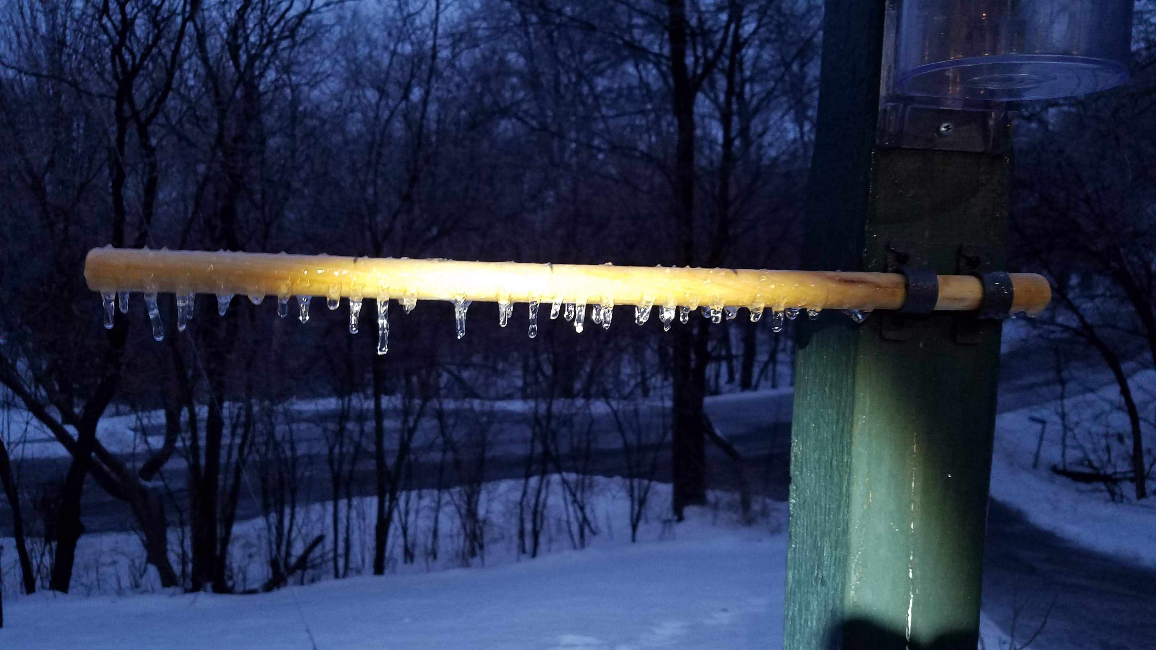
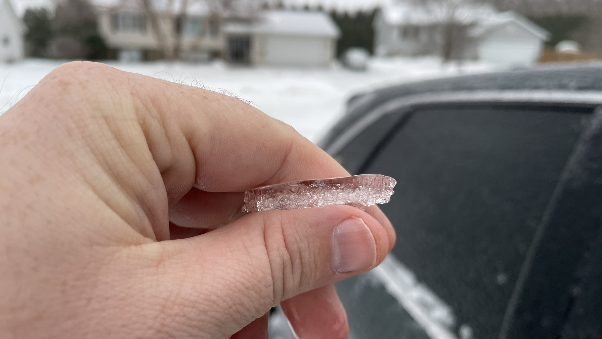
| Dakota, MN ice accumulation 7 am Tue Jan 3 2023 ​(NWS Andrea Skow) |
Dakota, MN ice accumulation 7 am Tue Jan 3 2023 ​(NWS Andrea Skow) |
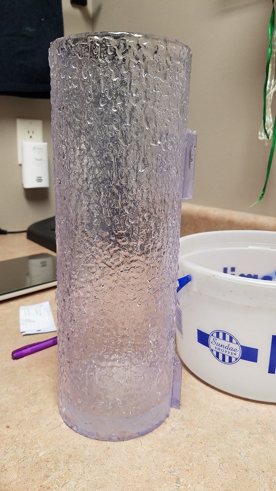
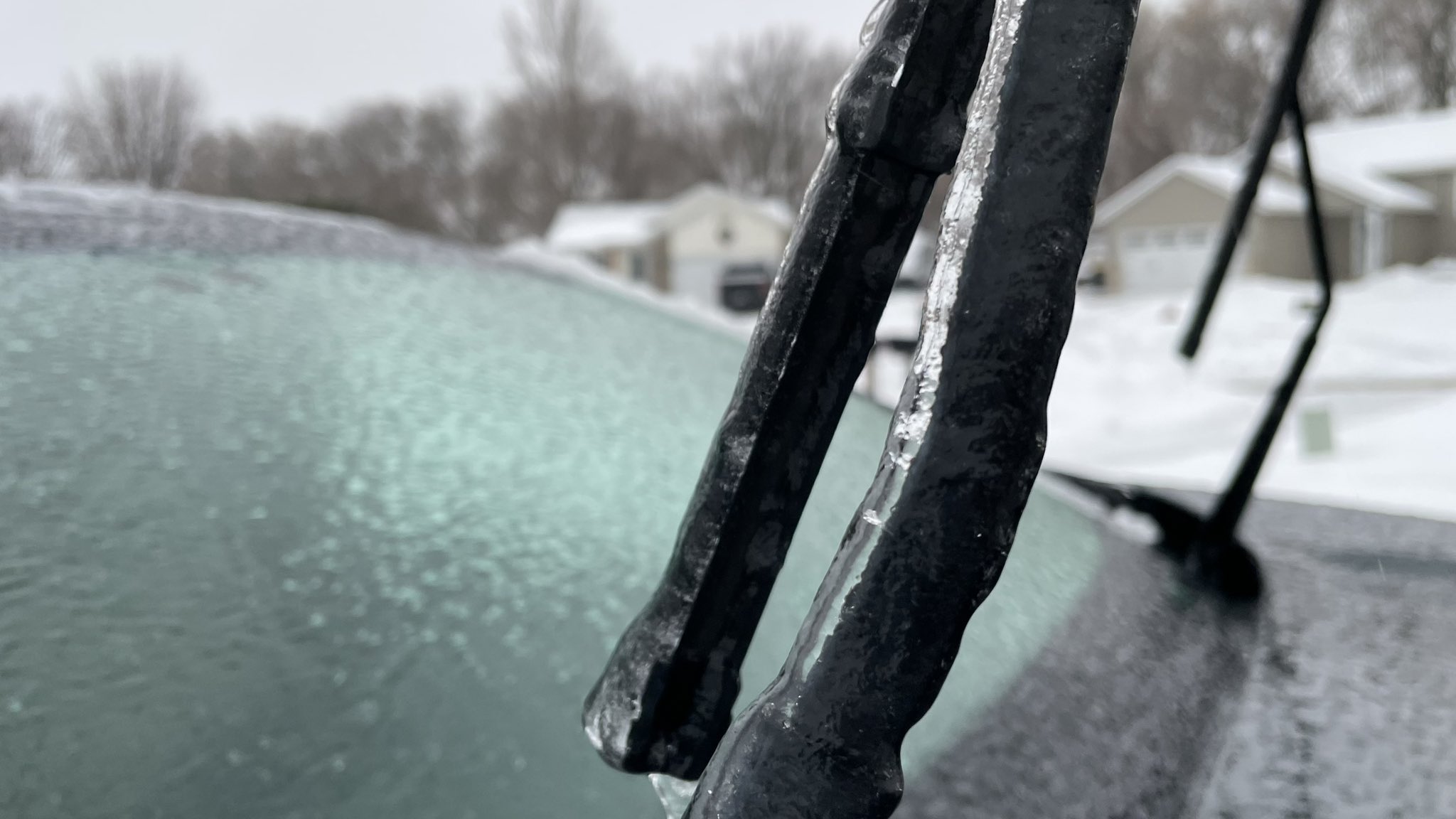
NWS La Crosse ice accumulation 915 am Tue Jan 3 2023 |
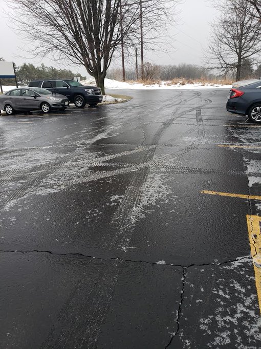
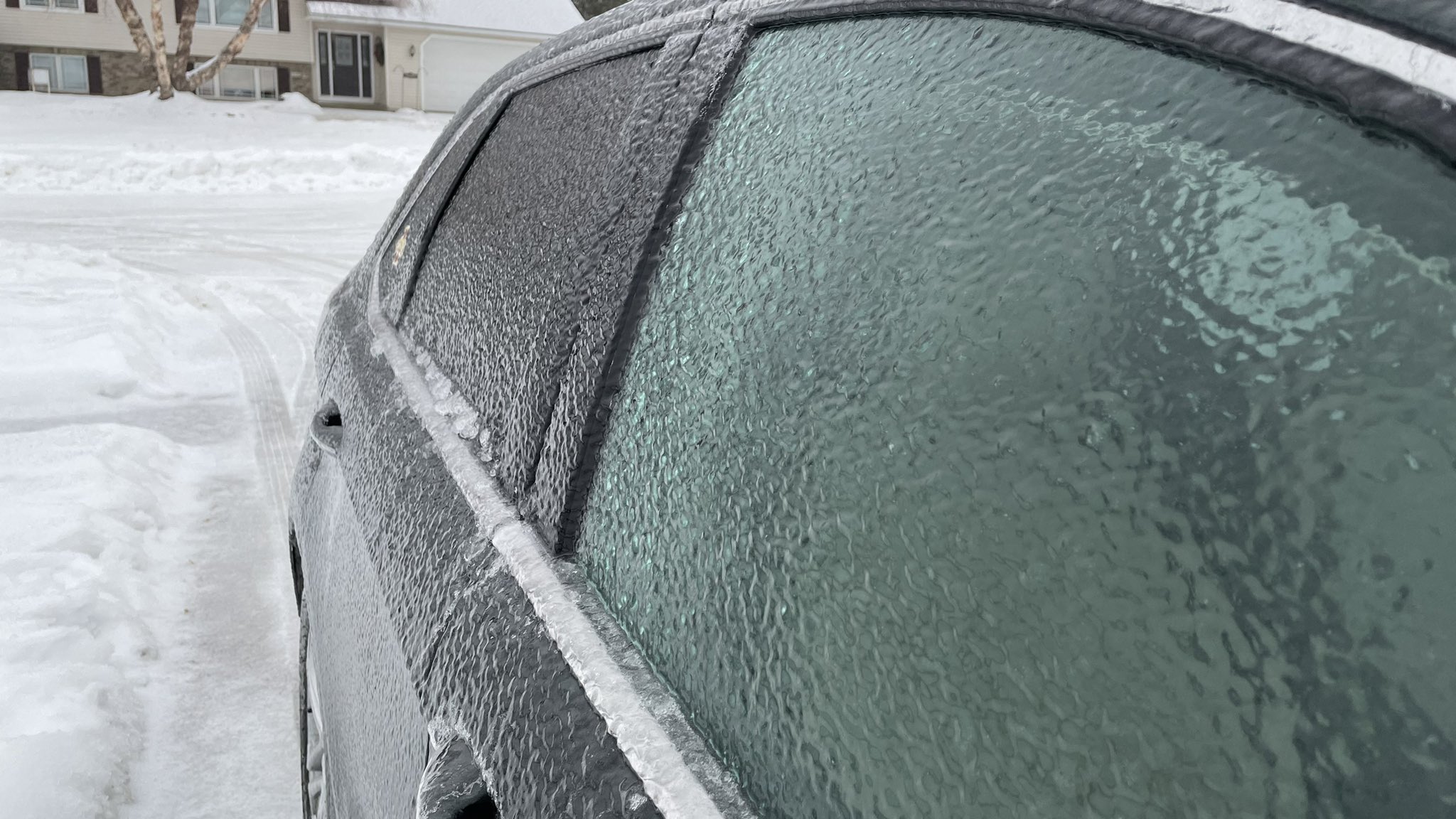
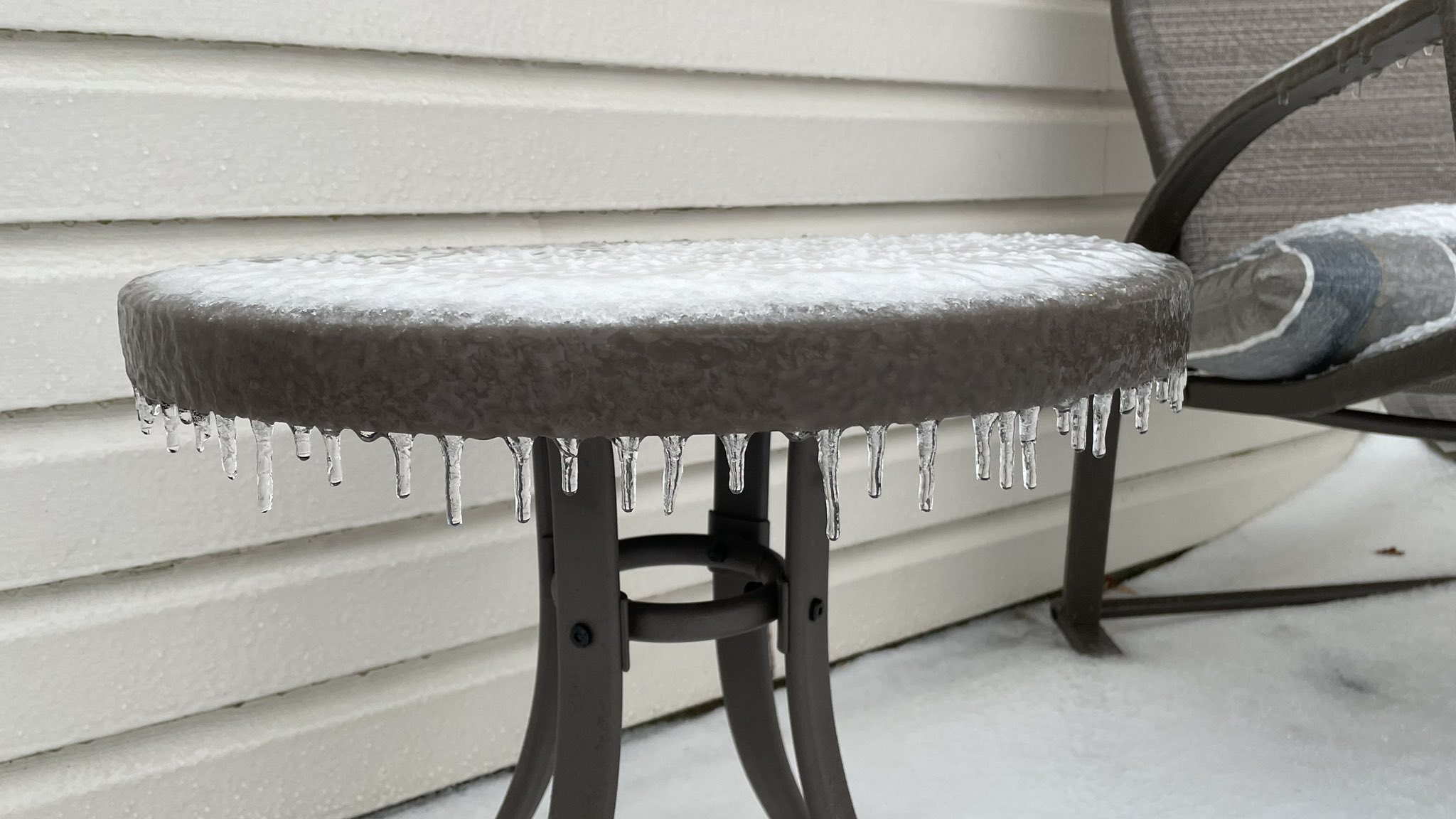
Rochester, MN ice accumulation 8 am Tue Jan 3 2023 (Twitter @ChrisKuball ABC 6 News) |
 |
 |
 |
|
| Rochester, MN ice Accumulation 8 am Tue Jan 3 2023 ​(Twitter @ChrisKuball ABC 6 News) |
Rochester, MN Ice Accumulation 8 am Tue Jan 3 2023 ​(Twitter @ChrisKuball ABC 6 News) |
Rochester, MN Ice Accumulation 8 am Tue Jan 3 2023 ​(Twitter @ChrisKuball ABC 6 News) |
 |
Media use of NWS Web News Stories is encouraged! Please acknowledge the NWS as the source of any news information accessed from this site. |
|

