
Blizzard conditions will develop across much of the area tonight, especially in rural wind-prone areas. This new snow will be lighter and fluffier, making it much more susceptible to blowing around in the strong winds. TRAVEL STRONGLY DISCOURAGED tonight! The Monday morning commute will be impacted. Sporadic power outages will be possible. Read More >
This page was developed and is maintained in cooperation with Hatfield Hydro & Black River Partners

2026 Recreational Flow Release Dates:
June 13
July 11
August 8
September 12
Release flows of 200 and 325 CFS are planned
over the course of 4 hours on these dates.
Additional details below.
Click Here For The Latest Precipitation Across The Area
** 24-Hr Precipitation **
Latest River Information (Click On The Image To Open The Latest Hydrograph)
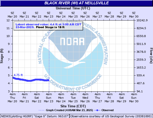 Black River - Neillsville |
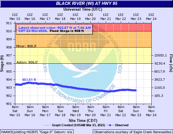 Black River - Highway 95 |
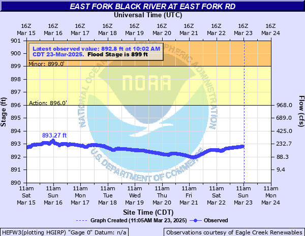 East Fork Black River - East Fork Road |
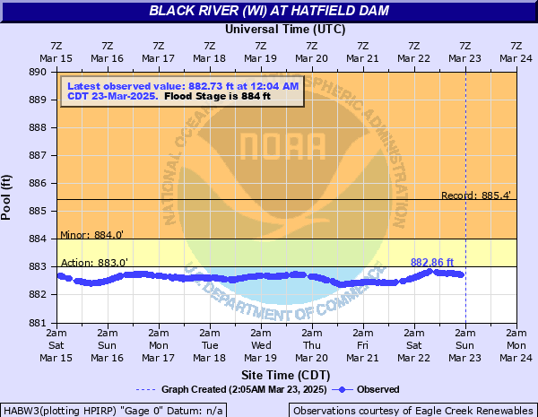 Lake Arbutus Pool Level - Hatfield Dam |
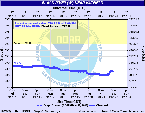 Black River - Hatfield Hydro Plant |
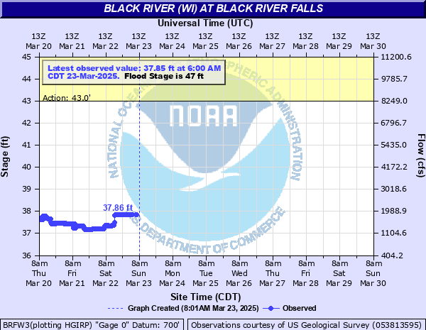 Black River - Black River Falls |
National Weather Service Product Listing
HATFIELD HYDRO FLOW RELEASE PLAN 2026
Whitewater Flow Releases on the Black River
Where: On the original river channel about 3.5 miles upstream from Hatfield Hydroelectric Project on the Black River.
When: Whitewater flow releases for 2026 will occur between 11:00 AM and 3:00 PM June 13, July 11, August 8, and September 12.
Description: The planned releases will create Class II, III, and IV pool-drop rapids depending on flow and location, requiring an intermediate to advanced skill level. Boaters should be aware that there are inherent risks associated with whitewater boating and are encouraged to use common sense at all times. Boating is at your own risk.
Please note: In addition to planned releases below, the Black River at Hatfield provides fantastic whitewater boating opportunities throughout the entire boating season. When total river flows at Hatfield Powerhouse gauge are in the 3000-3500 CFS (cubic feet per second) range, this inflow produces a renowned surf wave in the East Channel for expert enthusiasts. Other times of the year river flows are more accommodating to less experience paddlers. Varying river conditions are the result of inflow from upstream of the Hatfield Dam. Daily stream flow data and information regarding predicted flow volume for a planned release can be found on the National Weather Service (NWS) website(see below). Please note that the information provided by NWS is only an estimate and does not guarantee a specific river flow volume.
Targeted flow releases for 2026:
On the Thursday prior to a scheduled release, flows from the previous five days recorded at the Neillsville gauge will be used to determine an average flow during that period. Flow releases will be based on this value. See “Trigger Points” below.
Targeted flow rates are subject to following trigger points:
The releases (130 CFS inflow or 325 CFS) will be from the east side of the dam through the Tainter Gates, which will feed the class IV drops. Note: These drops become unboatable above 700 CFS.
Lake Levels:
Black River Partners LLC. must maintain the license-stipulated lake elevations and the minimum flow requirement. A concerted effort will be made to maintain lake levels at or near the high limits of the acceptable operating range prior to a scheduled flow release. This will minimize the possibility of a cancellation. Consequently, lake elevation must be at least 882.4 (NGVD) to begin the release and at or above 882.30 (NGVD) to continue the release. Predicted precipitation and other circumstances may necessitate a modified release at the discretion of the operator in charge.
Directions:
Access the main river channel via a service road going upstream/northwest of the HWY K Bridge. Yellow gates will be open into a small parking lot. Please don’t park on canal embankment.
Sign In: Please assist us with the monitoring of these events by signing in at the specified launch site. The attendance record helps assure future flow releases.
Information and River Forecast: https://www.weather.gov/arx/hatfield_arbutus_monitor
*Flow releases are provided by Hatfield Hydro (managed by Black River Partners LLC.) in conjunction with the Friends of the Black River, National Park Service, Wisconsin Department of Natural Resources, and American Whitewater.*
Other Relevant Links:


 Weather Story
 Weather Map
 Local Radar