|
Early morning wind chills of 15 to 30 below zero slowly ease through the late morning. The coldest conditions seen west of the Mississippi River in southeast Minnesota and northeast Iowa where a Cold Weather Advisory remains in effect until 9 am.
Winter weather potential returns Friday afternoon and evening. Current confidence places the highest totals in Wisconsin where 2" to 5" are currently forecasted. Amounts from 1" to 4" expected elsewhere. Depending on the evolution of the weather system, exact locations and amounts may change.
A narrow band of lighter snow moves from north to south Saturday morning through evening. Current confidence places highest accumulations of 1" to 3" from northeast Iowa into southwest Wisconsin. Although, higher values cannot be ruled out at this time. Exact locations, amounts, and subsequent impacts may change given the narrow nature of expected snowfall.
Continue to monitor trends. If you have travel plans, allow extra time. Leave extra space between yourself and the vehicle in front of you when travelling in winter weather. The Friday evening commute will be impacted for some.
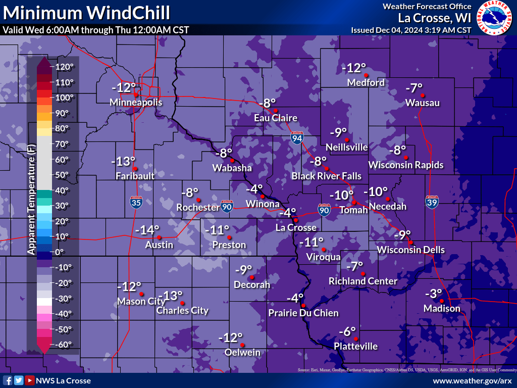
This Morning: Bitter Cold
- What: Wind chills from 15 to 30 below zero.
- Where: Primarily west of the Mississippi River Valley.
- Timing: Overnight and early Thursday morning.
- Impacts: Frost bite can occur in as little as 30 minutes.
- ACTION: Cover exposed skin. Wear several layers of clothing, hat, and gloves. Protect pets from the cold. Limit outdoor exposure if possible.
Friday Afternoon and Evening: Snow, Heavy At Times
- What: Snowfall, with totals of 2" to 5". Winds of 20 to 30 mph could cause drifting and blowing snow. 1 inch per hour snow rates possible in Wisconsin.
- Where: Entire area. Moderate confidence for highest amounts along and east of the Mississippi River.
- Timing: Begins Friday afternoon and ends Friday evening.
- Impacts: Evening commute impacted with snow covered roads and reductions in visibility. Some blowing and drifting of snow.
- ACTION: Anticipate slippery travel. Slow down, and allow extra time to reach your destination, and leave extra space between yourself and the car in front of you.
Saturday: Additional Light Snow
- What: Additional 1" to 3" with higher amounts possible in spots.
- Where: Mainly along and south of Interstate 90. Higher amounts may be possible primarily in northeast Iowa and southwest Wisconsin.
- Timing: Saturday morning through evening.
- Impacts: Snow covered roads and temporary reductions in visibility. Some blowing and drifting of snow.
- ACTION: Anticipate slippery travel. Slow down, and allow extra time to reach your destination, and leave extra space between yourself and the car in front of you.
Saturday Night Into Next Week: Dangerous Cold
- What: Wind chills 20 to 35 below zero at times.
- Where: Area wide. Coldest north and west of La Crosse.
- Timing: Coldest in the morning hours.
- Impacts: Frost bite can occur in 10 to 30 minutes. Hypothermia when outdoors for periods of time. Frozen pipes are possible in cold susceptible areas of the home.
- ACTION: Cover exposed skin. Wear several layers of clothing, hat, and gloves. Protect pets from the cold. Limit outdoor exposure if possible as there is the potential for hypothermia.

Friday Snow Forecast
|
Coldest Wind Chill
|
|
|
• Submit Report •
Winter Monitor
Precipitation Reports
Snowfall Plotter
Latest Winter Statement
Storm Reports
Latest Reports
Current Conditions

Weather Story

Radar
|

