
An additional round of severe weather will move into the region early this afternoon and depart before sunset. Large hail (2-3" diameter), damaging wind gusts and a few tornadoes, perhaps some strong (EF2-EF3) will be possible. Be sure to have multiple ways to receive warnings and to promptly head to your safe location when a warning is issued! Read More >
|
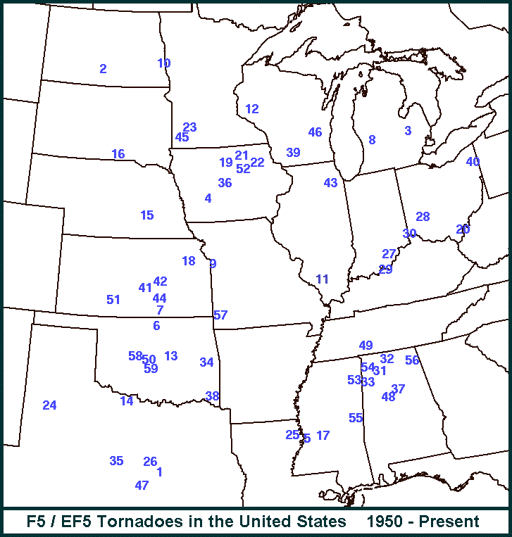
The damage survey has rated the Parkersburg, IA tornado on Sunday, May 25th as a low end EF5 tornado (correlated to wind speeds up to 205 mph). This was the second tornado (the first was Greensburg, KS on May 4, 2007) in the United States to receive this rating since the Fujita Scale was enhanced in 2006. EF5 tornadoes are equivalent to F5 tornadoes. |
F5/EF5 tornadoes since 1950 |
||||||||||||||||||||||||||||||||
| Since 1871, Iowa has had eleven F5/EF5 tornadoes (the most intense damage category on the Fujita and Enhanced Fujita damage scales - less than 1% of tornado occurrences - wind speeds greater than 200 mph). Since 1950, the United States has experienced fifty-three F5/EF5 tornadoes. Six of these tornadoes have occurred in Iowa. This ties Kansas and Texas for the greatest total of F5/EF5 tornadoes. Here is a monthly break down of the F5/EF5 tornadoes in the United States
The other F5/EF5 Iowa tornadoes are included in the table below: |
|||||||||||||||||||||||||||||||||
|
F5/EF5 Tornadoes that have occurred
in Iowa Since 1871* |
||||||
|
Counties
|
Date
|
Time in CST
|
Fatalities**
|
Injuries**
|
Length of Path (Miles)
|
Width
of Path (Feet) |
|
Greene, Boone, Story, Marshall, Jasper & Poweshiek
|
June 17, 1882
|
1830
|
68
|
300
|
105
|
2400
|
| This event may have begin as far west as Arcadia in Carroll County, but it is plotted here from southeast Greene County, and across southern Boone and Story Counties, where 16 farms were blown away. Ten people were killed near Rippley, Kelley, and in the southwest corner of Marshall County, as the tornado leveled farm after farm. This alone would have made it a major tornado event, but from there, the tornado continued to the southeast, killing seven people in Jasper County, and then devastating the town of Grinnell in Poweshiek County. The History of Poweshiek County counts 39 people dead at, or near, Grinnell as 73 homes were destroyed. Eye-witness descriptions point to the possibility of two tornadoes passing through together through Grinnell. Three of the deaths were students in the dormitory rooms at Grinnell College (which was called Iowa College at that time.) Grinnell damage totaled over $600,000. Continuing to the southeast, the tornado killed about 10 people in and near Malcolm, with $100,000 damage. Near the end of its path, two more people died 3 miles south of Brooklyn. There was downburst damage further to the southeast with some deaths. As with most tornadoes in the 19th century, the Grinnell death total is only an estimate, because no accurate storm survey was ever conducted. While the general movement was to the southeast, funnel clouds were reported as moving to the northeast. This indicates that the event was possibly a family of tornadoes. Each tornado turning to the northeast before lifting. Debris from Grinnell was reportedly found over 100 miles to the northeast in Wisconsin. Two people were killed on a train west of Grinnell. | ||||||
|
Cherokee, Buena Vista, Pocahontas, & Calhoun
|
July 16, 1893
|
1635
|
71
|
200
|
55
|
1500
|
| The tornado moved east southeast from 2 miles north of Quimby, passing 3 miles south of Alta, south of Newell, and crossing the northern part of Storm Lake. Homes were swept away in every county as the tornado was "bounding along the prairie like a huge ball." In Cherokee County, six people in a single family were killed. Three died in one family near Newell. Continuing east southeast, the tornado passed just to the south of many small communities along the railroad tracks and the tornado path finally coincided at the town of Pomeroy at 6:40 PM. Eighty percent of the homes of the 200 families in Pomeroy were damaged or destroyed, with many of them leveled to the ground. Damage was centered in the central and southern portions of town. The tornado lifted 3 miles east of Pomeroy, while still on a heading for Manson. Death toll estimates for this tornado vary from 50 to 100. Monthly Weather Review listed the death toll at 50. The Report of the Chief of the Weather Bureau listed 89 deaths. The latter death total is possible only if every rumored dead or seriously injured person is counted. From the study that Thomas P. Gazulis (A Chronology and Analysis of Events: Significant Tornadoes 1680-1991) conducted the death count was settled to be 71. These fatalities would include12 in Cherokee County, 6 in Buena Vista County, 4 in Pocohontas County, and 49 in Calhoun (mainly in an around Pomeroy). Losses totaled about $400,000 for all counties. | ||||||
|
Kossuth, Hancock,Winnebago, IA & Faribault, MN
|
Sep 21, 1894
|
2000
|
14
|
100
|
50
|
4500
|
| This tornado moved east northeast from 3 miles north of Whitemore, then gradually turning to the northeast crossing the northwest corner of Hancock County. It passed between Buffalo Center and Thompson and ended near Kiester, MN. At least ten farms in Kossuth County were entirely leveled and swept away, with five or more having "little left to show that a farm once existed on the site." At least 13 deaths occurred in Kossuth County, with losses at over $500,000. One person died east of Buffalo Center, as a "home was wiped out of existence." It is possible that an F3 tornado struck west of Buffalo Center. | ||||||
|
Sioux
|
May 3, 1895
|
1520
|
9
|
35
|
13
|
3000
|
| The tornado moved northeast from 3 miles north of Ireton to 2 miles southwest of of Hull. This tornado hit four schools. Two school houses several miles apart were leveled killing teachers and students. The dead teacher at the teacher at the first school (George Marsden at the Haggie School) was the brother of the teacher killed at the second school (Ann Marsden at the Coombs School). Adjoining farms were entirely leveled, with several deaths in homes. School children were carried for up to a half mile, and many sustained injuries that would be life-long burdens. Some publications put the death toll at 15. | ||||||
|
Crawford, Carroll, & Greene
|
May 21, 1918
|
1430
|
4
|
30
|
37
|
2400
|
| This tornado moved east northeast from 5 miles east of Denison to near Adaza. Twenty or more farms were devastated, and debris were carried for miles. A couple died in their home northeast of Carroll. Another couple were caught in a buggy racing home, north of Churdan, and was killed. No schools were apparently hit, although they were in session. Mattresses were carried two miles, as foundation of homes and barns were left bare. Damage was estimated at $300,000. | ||||||
|
Cass & Adair
|
June 27, 1953
|
1545
|
1
|
2
|
10
|
300
|
| This tornado moved east northeast from 5 miles southwest of Adair to four miles south of town. Four farms were destroyed. Virtually nothing was left on the site of a farm near the county border. Heavy machinery was thrown over 100 yards and boards were driven into trees. Damage was estimated at $100,000. | ||||||
|
Wright
|
October 14, 1966
|
1355
|
6
|
172
|
19.7
|
3000
|
| The tornado moved north northeast from one mile north of Clarion to Belmond where a large section of town was devastated. About 109 homes were destroyed and 468 were damaged. Between Clarion and Belmond, 27 farms were hit, and several farm homes were leveled. About 75 of the 112 businesses in town were destroyed or damaged. The threatening skies had forewarned the crowd at the homecoming parade, and they had dispersed. Five of the six deaths were elderly people. One man died in a cement mixer truck. | ||||||
|
Franklin, Butler, Floyd, Chickasaw, & Howard
|
May 15,1968
|
1510
|
13
|
450
|
62.1
|
1800
|
| Tornado first sighted passing over a farmstead northeast of Hansell. It moved over the east edge of Aredale. Two funnels were simultaneously sighted at Aerdale. A funnel was observed to lift at Marble Rock. A continuous tornado path and associated tornado sightings were reported from east of Marble Rock to Charles City. The northeastward path of the tornado became northward as it swept through downtown Charles City at 3:47 p.m. and then recurving as it left Charles City to move northeast to Elma, passing northeastward across Elma and thence moving north-northeast to Highway 9 and finally north and northwest as it dissipated south of Chester. The greatest losses were in Charles City where 13 persons were killed, 450 injured of which 76 were hospitalized. 337 homes were completely destroyed and 1565 families in Charles City were affected by the tornado. Losses were estimated up to 30 million dollars. In Elma 12 persons were injured, 3 hospitalized and damage estimated at 1.5 million dollars. Additionally many farmsteads and rural homes were damaged or destroyed. The tornado entered Elma at 4:25 p.m. and continued to a point 14 miles north of Elma where its destructive path ended. | ||||||
|
Fayette
|
May 15,1968
|
1557
|
5
|
156
|
13.1
|
500
|
| The tornado passed through downtown Oelwein and moved north-northeast to Maynard moving through the town in a northward direction. It ended about 5 miles north-northeast of Maynard. Of the 156 injuries, 34 were hospitalized. 965 families were affected by the tornado. Loss estimates ranged upward to 21 million dollars. Most of which occurred in Oelwein. | ||||||
|
Boone & Story
|
June 13,1976
|
1425
|
0
|
9
|
21.3
|
2640
|
| This tornado first appeared as "the spinning underside of a saucer" (large rotating wall cloud) 3 miles southwest of Luther. The tornado moved northeast passing one mile north of Luther where it turned to the north. The massive tornado then passed through and destroyed the hamlet of Jordan. The tornado then curved to the northwest, then made a 110 degree turn, and moved east to just over the county line. From there damage was continuous to Story City, but not everyone agrees whether that damage was from microbursts or tornadoes. About 75% of Story City had some kind of wind damage (mostly F0). The F4 and F5 damage was in rural areas in and near Jordon. Hundreds of animals on nearby farms were killed. The tornado was on the ground about an hour. The unusual U-shaped path was probably caused by an interaction with some manner of cold air outflow from the parent thunderstorm. | ||||||
| * The data in this table came from Storm Data, Significant Tornadoes--1680-1991 by Thomas P. Grazulis and the TornadoHistoryProject.com ** Injuries and Deaths are for the entire tornado track. |
||||||


 Weather Story
 Weather Map
 Local Radar