Temperatures:
|
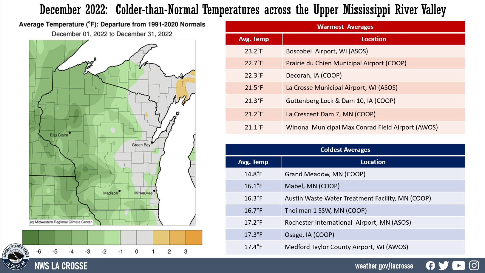
During December 2022, monthly temperatures ranged from 14.8°F at Grand Meadow, MN (COOP) to 23.2°F at Boscobel Airport, WI (ASOS). These temperatures were up to 6°F colder than normal. The warmest temperature was 54°F at Guttenberg Lock & Dam 10, IA (COOP) & Lancaster 4 WSW, WI (COOP) on December 30, and the coldest temperature was -17°F near Mather, WI (COOP) on December 24. |
 |
Precipitation:
|
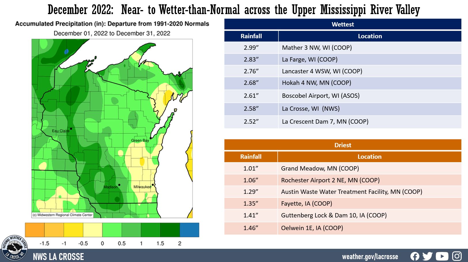
December 2022 precipitation anomalies ranged from near-normal to 2.5” wetter-than-normal across the Upper Mississippi River Valley. Precipitation totals ranged from 1.01” at Grand Meadow, MN (COOP) to 4.01” at Black River Falls, WI (COOP). The greatest 1-day precipitation was 2.31" at Black River Falls, WI (COOP). This precipitation fell from 7 AM on December 14 to 7 AM on December 15. |
 |
Snowfall:
|
Snowfall was up to 10” above-normal for the month. Snowfall ranged from 7.3” near Oelwein, IA (COOP) to 21.1” at La Farge, WI (COOP). The greatest 1-day snowfall was 6" near Decorah, IA (COOP). This snow fell from 7 AM on December 8 to 7 AM on December 9. |
 |
Below are December 2022 climate summaries for La Crosse, WI, and Rochester, MN.
Temperatures - Colder-than-Normal
|
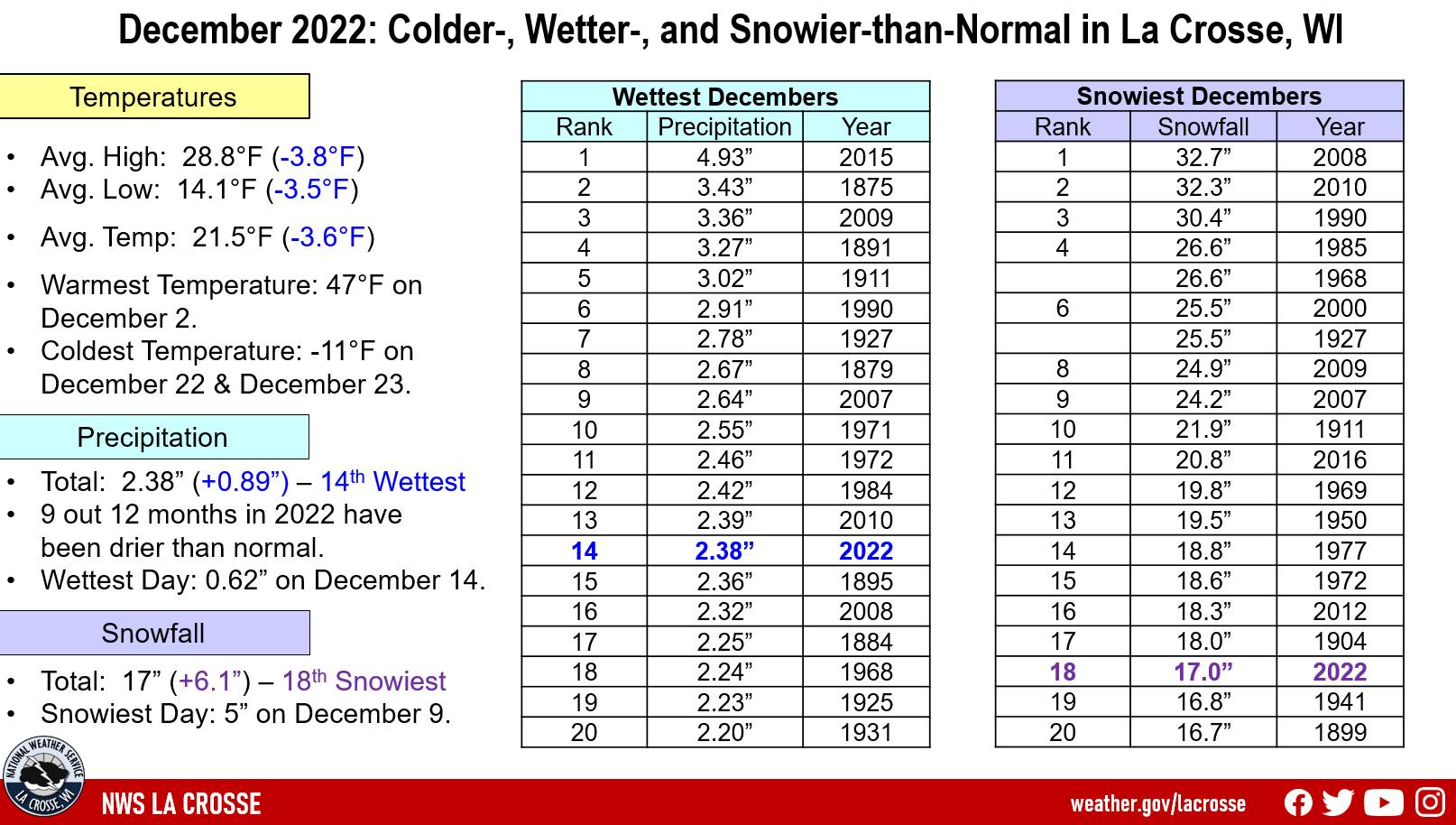 |
Precipitation - 14th Wettest
Twenty Wettest Decembers
in La Crosse WI
1872-2022
Rank Precipitation Year
---- ------------- ----
1 4.93 inches 2015
2 3.43 inches 1875
3 3.36 inches 2009
4 3.27 inches 1891
5 3.02 inches 1911
6 2.91 inches 1990
7 2.78 inches 1927
8 2.67 inches 1879
9 2.64 inches 2007
10 2.55 inches 1971
11 2.46 inches 1972
12 2.42 inches 1984
13 2.39 inches 2010
14 2.37 inches 2022
15 2.36 inches 1895
16 2.32 inches 2008
17 2.25 inches 1884
18 2.24 inches 1968
19 2.23 inches 1925
20 2.20 inches 1931
Snowfall - 18th Snowiest December
Twenty Snowiest Decembers
in La Crosse WI
1896-2022
Rank Snowfall Year
---- -------- ----
1 32.7 inches 2008
2 32.3 inches 2010
3 30.4 inches 1990
4 26.6 inches 1985
26.6 inches 1968
6 25.5 inches 2000
25.5 inches 1927
8 24.9 inches 2009
9 24.2 inches 2007
10 21.9 inches 1911
11 20.8 inches 2016
12 19.8 inches 1969
13 19.5 inches 1950
14 18.8 inches 1977
15 18.6 inches 1972
16 18.3 inches 2012
17 18.0 inches 1904
18 17.0 inches 2022
19 16.8 inches 1941
20 16.7 inches 1899
Snow Depth - Greater than the Long-Term Average
...Records...
...Looking ahead to January...
The normal high temperatures in La Crosse range from 27 to 28°F. The coldest normal high temperatures occur from January 8 through January 27. The normal low temperatures range from 10 to 13°F. The coldest low temperatures occur from January 13 through the end of the month. The warmest January temperature on record is 57°F on January 3, 1874, January 1, 1897, and January 25, 1981, and the coldest temperature is -43°F on January 18, 1873.
The normal mean temperature for the month is 18.9°F. La Crosse’s warmest January occurred in 1880 with an average temperature of 32°F, and their coldest January occurred in 1912 with an average temperature of -1.1°F (coldest month ever recorded).
The normal January precipitation is 1.25". The wettest January occurred in 1886 with 3.44" of precipitation and the driest January occurred in 1948 and 1981 with just 0.14". The wettest January day occurred on January 5, 1946, when 1.67" of precipitation fell.
The normal January snowfall is 11.8" (the snowiest month on average). The snowiest January occurred in 1929 with 39.6" of snow (the snowiest month ever recorded) and the least snow was 1.6" in 1903 and 2006. The snowiest January day occurred on January 26, 1996, when 12" of snow fell.
Temperatures - Colder-than-Normal
|
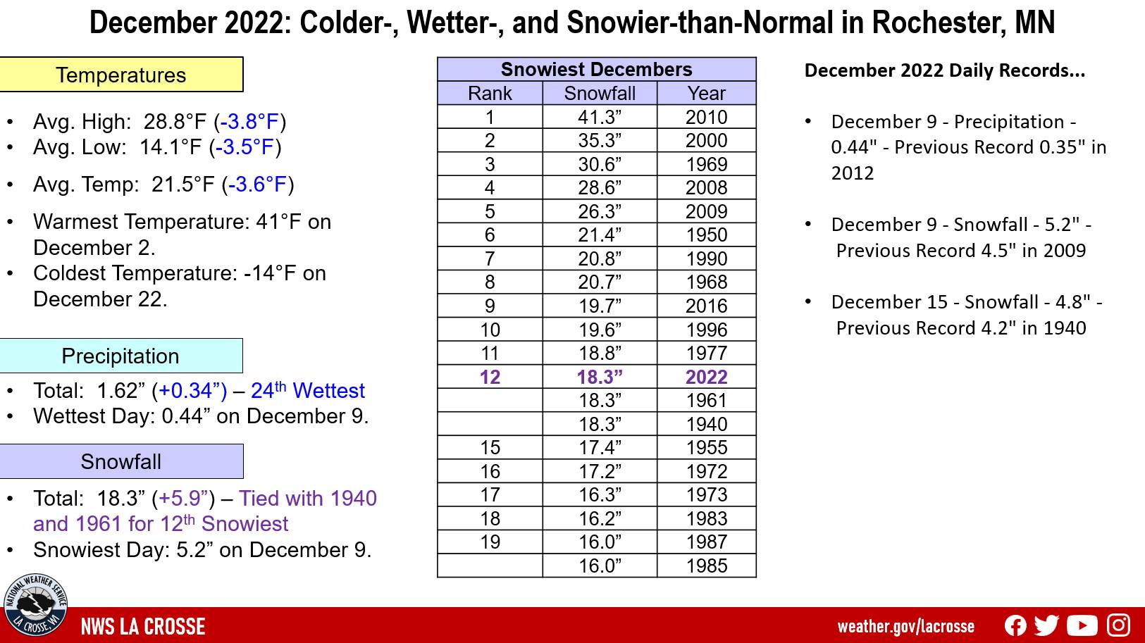 |
Precipitation - 24th Wettest
A total of 1.62" of precipitation fell. Which was 0.34" wetter than the 1991-2020 normal of 1.28". This was the 24th wettest and the wettest since 2018 (2.10" - 10th wettest).
10 out of the last 17 Decembers have been wetter than normal.
The wettest day was December 9 when 0.44 inches of precipitation fell.
Snowfall - Tied for 12th Snowiest
A total of 18.3" of snow fell. Which was 5.9" snowier than the 1991-2020 normal of 12.4".
This was tied for the 12th snowiest with 1940 and 1961 and it was the snowiest December since 2016 (19.7" - 9th snowiest December).
6 out of the 14 snowiest Decembers have occurred since 2000.
Twenty Snowiest Decembers
in Rochester MN
1908-2022
Rank Snowfall Year
---- -------- ----
1 41.3 inches 2010
2 35.3 inches 2000
3 30.6 inches 1969
4 28.6 inches 2008
5 26.3 inches 2009
6 21.4 inches 1950
7 20.8 inches 1990
8 20.7 inches 1968
9 19.7 inches 2016
10 19.6 inches 1996
11 18.8 inches 1977
12 18.3 inches 2022
18.3 inches 1961
18.3 inches 1940
15 17.4 inches 1955
16 17.2 inches 1972
17 16.3 inches 1973
18 16.2 inches 1983
19 16.0 inches 1987
16.0 inches 1985
Snow Depth - Greater than the Long-Term Average
...Records...
Daily...
...Looking ahead to December...
The normal high temperatures in Rochester range from 22 to 24°F. The coldest normal high temperatures occur from January 10 through January 26. The normal low temperatures range from 6 to 9°F. The coldest low temperatures occur from January 18 through January 30. The warmest January temperature on record is 58°F on January 25, 1944, and the coldest temperature is -42°F on January 7, 1887.
The normal mean temperature for the month is 14.7°F. Rochester’s warmest January occurred in 2006 with an average temperature of 28.1°F, and their coldest January occurred in 1912 with an average temperature of -3.8°F (coldest month ever recorded).
The normal January precipitation is 0.99" (driest month on average). The wettest January occurred in 1888 with 2.92" of precipitation and the driest January occurred in 1961 with just 0.07". The wettest January day occurred on January 6, 1888, when 1.50" of precipitation fell.
The normal January snowfall is 12.2" (2nd snowiest month by average). The snowiest January occurred in 1996 with 30.2" of snow and the least snow was 0.8" in 2006. The snowiest January day occurred on January 22, 1982, when 15.4" of snow fell.


 Weather Story
 Weather Map
 Local Radar