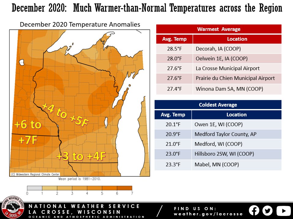
During December 2020, average temperatures ranged 3 to 7F warmer-than-normal across the Upper Mississippi River Valley. This was the second month in a row that temperatures averaged well-above normal. Average temperatures ranged from 20.1F at Owen, WI to 28.5F at Decorah, IA.
Precipitation totals ranged from 0.15” at Alma Dam WI and Austin MN to 1.20” at Preston, MN. This resulted in precipitation deficits ranging from a half to 1.5 inches below normal.
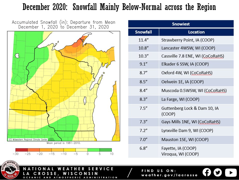
Snowfall was up to 10 inches below normal across the Upper Mississippi River Valley. The highest snow total was 11.4 inches at Strawberry Point, IA. More details for La Crosse, WI and Rochester, MN can be found below the images.
 |
 |
 |
| Temperature Anomalies | Precipitation Anomalies | Snowfall Anomalies |
...Month Highlights...
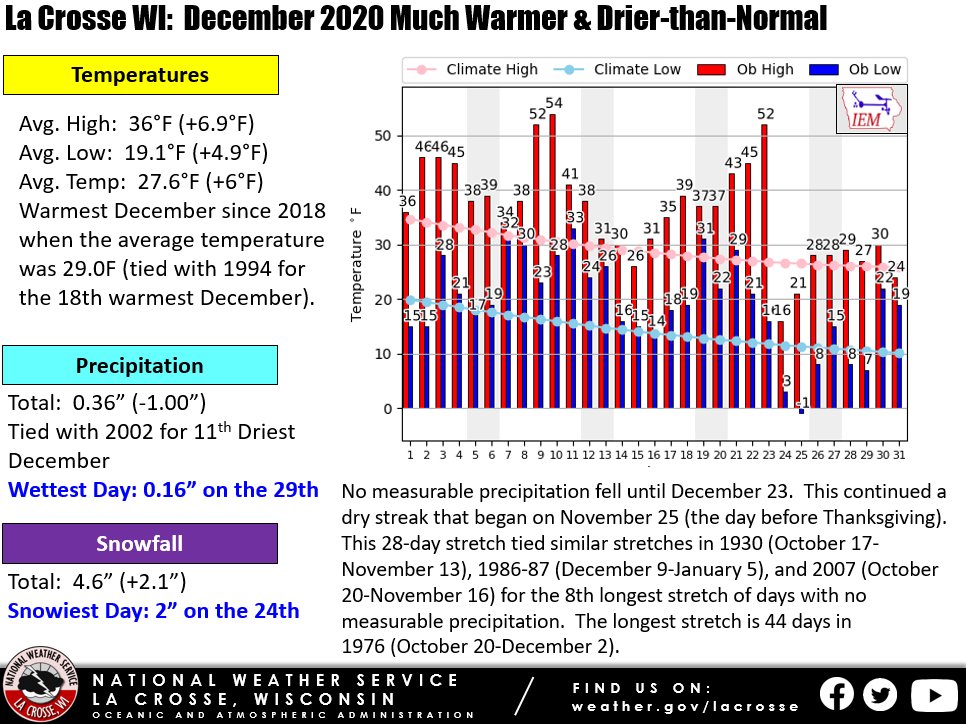
During December 2020, the average temperature at La Crosse Regional Airport was 27.6 degrees. This was 6F warmer than the 1981-2010 normal of 21.6F. This was the warmest December since 2018 when the average temperature was 29.0F (tied with 1994 for the 18th warmest December).
Only 0.36 inches of precipitation fell during December. This was 1 inch drier than the 1981-2010 normal of 1.36 inches. This tied 2002 for the 11th driest December. It was the driest December since 2002. The driest December occurred in 1943 when 0.01 inches of precipitation fell.
No measurable precipitation fell until December 23. This continued a dry streak that began on November 25 (the day before Thanksgiving). This 28-day stretch tied similar stretches in 1930 (October 17-November 13), 1986-87 (December 9-January 5), and 2007 (October 20-November 16) for the 8th longest stretch of days with no measurable precipitation. The longest stretch is 44 days in 1976 (October 20-December 2).
A total of 4.6 inches of snow fell. This was 6.7 inches below the 1981-2010 normal of 11.3 inches. Typically, December is La Crosse's snowiest month of the winter.
...Records...
None.
...Looking ahead to January...
January is the coldest month of the year in La Crosse with an average temperature of 17.4 degrees. The average high is 25.9 degrees and the average low is 8.9 degrees. The average daily high temperature starts at 26 degrees then dips to 25 degrees by the 6th and ends up at 27 degrees on the 31st. The average low temperature is 10 degrees on the 1st, then drops to 8 degrees above zero on the 17th and jumps back up to 9 degrees on the 22nd.
Normal precipitation for January is 1.12 inches of liquid with 10.7 inches of snow.
|
...Month Highlights...
During December 2020, the average temperature was 24.7F at Rochester International Airport. This was 5F warmer than the
1981-2010 normal of 19.7F. This was the 16th warmest December. This was the warmest December since 2015 when the average temperature was 29.8F (2nd warmest December - only 1931 was warmer with an average temperature of 30.7F). 11 out of the 20 warmest Decembers have occurred since 1997.
Only 0.20 inches of precipitation fell during December. This was 1.03 inches drier than the 1981-2010 normal of 1.23 inches. It was the 5th driest December and the driest December since 1943 when just a trace of precipitation fell. The table below lists the ten driest
Decembers in Rochester.
Ten Driest Decembers
in Rochester MN
1886-2020
Precipitation
Rank Total Year
---- ------------- ----
1 Trace 1943
2 0.07 inches 1929
3 0.13 inches 1913
4 0.18 inches 1917
5 0.20 inches 2020
6 0.22 inches 1967
0.22 inches 1958
8 0.28 inches 1998
0.28 inches 1962
0.28 inches 1914
A total of 3.9 inches of snow fell. This was 8.6 inches below the 1981-2010 normal of 12.5 inches. Typically, December is Rochester's snowiest month of the winter.

...Records...
December 9 - Record High Tied - 52F - Last set in 1918
December 23 - Record High Broken - 47F - Previous Record 43F in 1936
...Looking ahead to January...
January is the coldest month of the year in Rochester with an average temperature of 15.7 degrees. The average high is 23.6 degrees and the average low is 7.7 degrees. The average daily high temperature starts at 24 degrees, then dips to 23 degrees by the 2nd week, and then ends up at 25 degrees on the 31st. The average low temperature is 9 degrees on the 1st, then drops to 7 degrees by mid-month, then rises to 8 degrees on the 31st.
Normal precipitation for January is 0.86 inches with 12.0 inches of snow.

