Temperatures:
|
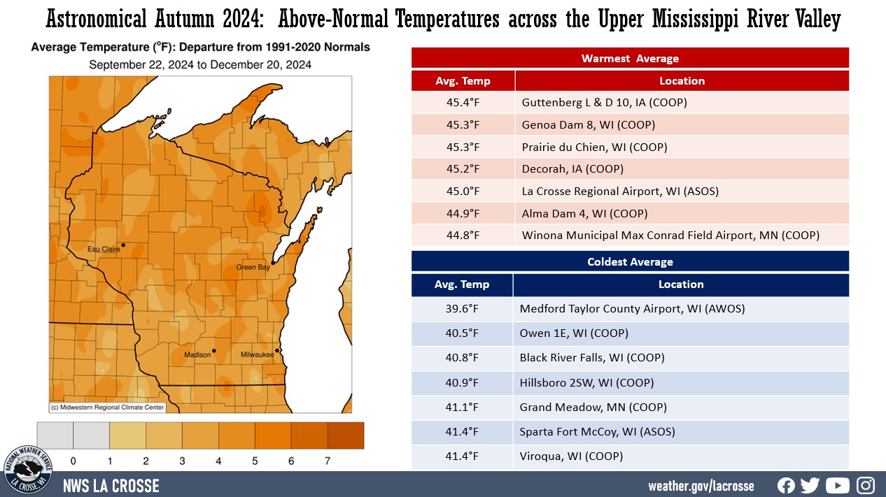
During Astronomical Autumn 2024 (September 22 through December 20), average temperatures ranged from 39.6°F at Medford Taylor County Airport, WI (AWOS) to 45.4°F at Guttenberg Lock & Dam 10, IA (COOP) in the Upper Mississippi River Valley. Temperature anomalies ranged from 2°F to 6°F warmer than normal. The hottest temperature was 91°F at Decorah, IA (COOP) and Oelwein, IA (COOP) on September 22. Meanwhile, the coldest temperature was -14°F at Black River Falls, WI (RAWS) and Owen, WI on December 13.
|
 |
Precipitation:
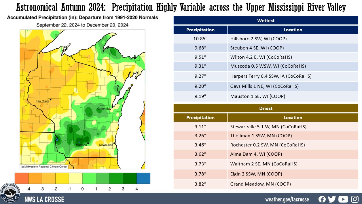
| Precipitation was highly variable across the Upper Mississippi River Valley. Precipitation varied from 3.11" near Stewartville, MN (CoCoRaHS) to 12.62" near Hillsboro, WI (COOP). Precipitation anomalies ranged from 4" below normal to 5" wetter than normal. The highest one-day precipitation was 3.11" near Platteville (CoCoRaHS) from October 30 through October 31. |
 |
Snowfall:
|
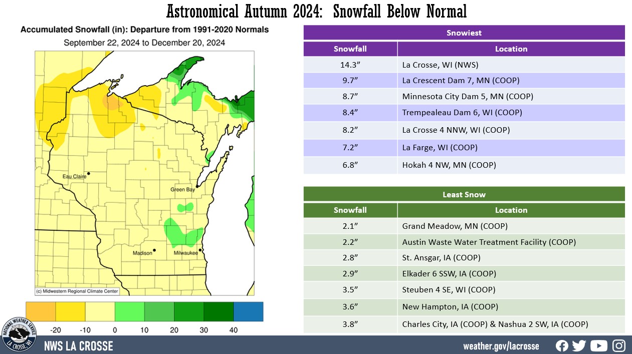
Snowfall was primarily below normal. Totals ranged from 2.1" at Grand Meadow, MN (COOP) to 14.3" at NWS La Crosse, WI. These values were up to 10 inches below normal. The snowiest day was 8.4" near Oxford, WI (CoCoRaHS) from 7 AM on December 19 to 7 AM on December 20.
|
 |
The information below details astronomical autumn 2023 temperatures, precipitation, and snowfall for La Crosse WI, and Rochester MN.
La Crosse WI...
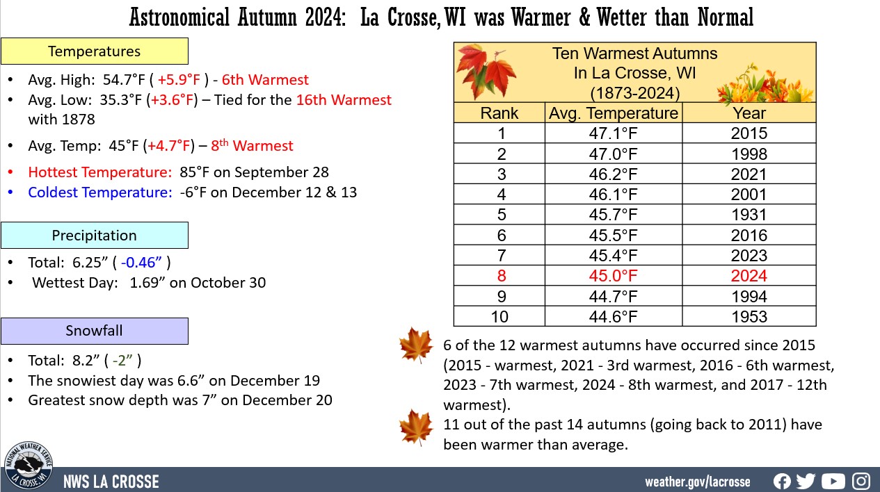
The astronomical Autumn of 2024 (September 22 through December 20) was warmer and wetter than normal in La Crosse, WI. More details can be found below.
Temperatures - 8th Warmest
- During astronomical autumn, La Crosse Regional Airport had an average temperature of 45.0°F.
- This was 4.7°F warmer than the 1873-2024 long-term average of 40.3°F.
- This was the 8th warmest autumn.
- 6 of the 12 warmest autumns have occurred since 2015 (2015 - warmest, 2021 - 3rd warmest, 2016 - 6th warmest, 2023 - 7th warmest, 2024 - 8th warmest, and 2017 - 12th warmest).
- 11 out of the past 14 autumns (going back to 2011) have been warmer than average.
- The table below lists the 10 warmest autumns in La Crosse, WI.
|
 |
Ten Warmest Astronomical Autumns
in La Crosse, WI
1873-2024
Average
Rank Temperature Year
---- ----------- ----
1 47.1°F 2015
2 47.0°F 1998
3 46.2°F 2021
4 46.1°F 2001
5 45.7°F 1931
6 45.5°F 2016
7 45.4°F 2023
8 45.0°F 2024
9 44.7°F 1994
10 44.6°F 1953
- The average high temperature was 54.7°F which was 5.9°F warmer than the 1873-2024 long-term average of 48.8°F. This was the 6th warmest and the warmest since 2021 (55.6°F - 3rd warmest).
- The average low temperature was 35.3°F which was 3.6°F warmer than the 1873-2024 long-term average of 31.7°F. This was tied with 1878 for the 16th warmest and the warmest since 2023 (37.1°F - 6th warmest).
- The hottest high temperature was 85°F on September 28.
- The coldest high temperature was 7°F on December 12.
- The warmest low temperature was 59°F on October 20 and October 29.
- The coldest low temperature was -6°F on December 12 and December 13.
Precipitation - Slightly Wetter-than-Average
- During astronomical autumn, La Crosse Regional Airport received 6.25 inches of precipitation. Which was 0.46 inches wetter than the 1873-2024 long-term average of 5.79 inches.
- The wettest day occurred on October 30 when 1.69 inches fell.
- No precipitation fell on 58 days (64.4%).
- A trace of precipitation fell on 13 days (14.4%).
- Measurable (0.01 inches or greater) fell on 19 days (21.1%).
Snowfall - Below Average
- During astronomical autumn, the official NWS snow observer near La Crosse Regional Airport received 8.2 inches of snow. This was 2 inches below the 1897-2024 long-term average of 10.2 inches.
- The snowiest day occurred on December 19 when 6.6 inches fell.
- No snow fell on 76 days (84.4%).
- A trace of snow fell on 10 days (11.1%).
- Measurable (0.1" or greater) fell on 4 days (4.4%).
Snow Depth - Below Average
- During astronomical autumn, the official NWS snow observer near La Crosse Regional Airport had an average snow depth of 0.1 inches. This was 0.5 inches below the 1893-2024 long-term average of 0.6 inches.
- The greatest snow depth was 7 inches on December 20.
Rochester MN...
The astronomical Autumn of 2024 (September 22 through December 20) was warmer and drier than normal at Rochester, MN. More details can be found below.
Temperatures - 7th Warmest
- During astronomical autumn, Rochester International Airport had an average temperature of 42.2°F.
- This was 4.6°F warmer than the 1886-2024 long-term average of 37.6°F.
- This was tied for the 7th warmest with 1953 and 2012.
- 12 out of the 17 warmest autumns have occurred since 1998.
- 17 out of the past 21 autumns (since 2005) have been warmer than average.
- The table below lists the 10 warmest autumns in Rochester, MN.
|
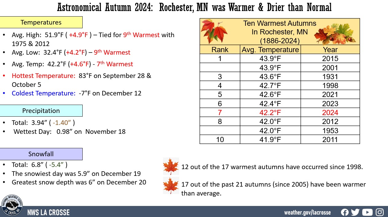 |
Ten Warmest Astronomical Autumns
in Rochester MN
1886-2024
Average
Rank Temperature Year
---- ----------- ----
1 43.9°F 2015
43.9°F 2001
3 43.6°F 1931
4 42.7°F 1998
5 42.6°F 2021
6 42.4°F 2023
7 42.2°F 2024
8 42.0°F 2012
42.0°F 1953
10 41.9°F 2011
- The average high temperature was 51.9°F which was 4.9°F warmer than the 1886-2024 long-term average of 47°F. This was tied for the 9th warmest with 1975 and 2012 and the warmest since 2021 (52°F - 8th warmest).
- The average low temperature was 32.4°F which was 4.2°F warmer than the 1886-2024 long-term average of 28.2°F. This was 9th warmest and the warmest since 2023 (33.3°F - tied with 2021 for the 5th warmest).
- The warmest high temperature was 83°F on September 28 and October 5.
- The coldest high temperature was 4°F on December 12.
- The warmest low temperature was 58°F on October 20.
- The coldest low temperature was -7°F on December 12.
Precipitation - Drier than Normal
- During astronomical autumn, Rochester International Airport received 3.94 inches of precipitation. Which was 1.40 inches drier than the 1886-2024 long-term average of 5.34 inches.
- The wettest day occurred on November 18 when 0.98 inches fell.
- No precipitation fell on 61 days (67.8%).
- A trace of precipitation fell on 9 days (10%).
- Measurable (0.01 inches or greater) fell on 20 days (22.2%).
Snowfall - Below Average
- During astronomical autumn, the official NWS snow observer near Rochester International Airport received 6.8 inches of snow. This was 5.4 inches less than the 1933-2024 long-term average of 12.2 inches.
- The snowiest day occurred on December 19 when 5.9 inches fell.
- No snow fell on 75 days (83.3%).
- A trace of snow fell on 10 days (11.1%).
- Measurable (0.1 inches or greater) fell on 5 days (5.6%).
Snow Depth - Below Average
- During astronomical autumn, the official NWS snow observer near Rochester International Airport had an average snow depth of 0.1 inches. This was 0.7 inches less than the 1944-2024 long-term average of 0.8 inches.
- The greatest snow depth was 6 inches on December 20.