Temperatures:
|
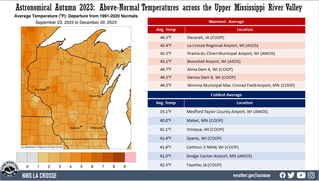
During Astronomical Autumn 2023 (September 23 through December 20), average temperatures ranged from 39.1°F at Medford Taylor County Airport, WI (AWOS) to 46.3°F at Decorah, IA (COOP) in the Upper Mississippi River Valley. Temperature anomalies ranged from 1°F to 6°F warmer than normal. The hottest temperature was 100°F at Boscobel Airport, WI (ASOS) on September 3. Meanwhile, the coldest temperature was -6°F at Black River Falls, WI (RAWS) on November 28. |
 |
Precipitation:
| Precipitation was highly variable across the Upper Mississippi River Valley. Precipitation varied from 4.40" near Oelwein, IA (COOP) to 16.72" at Black River Falls Sewage, WI (COOP). Precipitation anomalies ranged from 4" below normal to 8" wetter than normal. The highest one-day precipitation was 6.23" at Black River Falls Sewage, WI (COOP) from October 24 through October 25. | 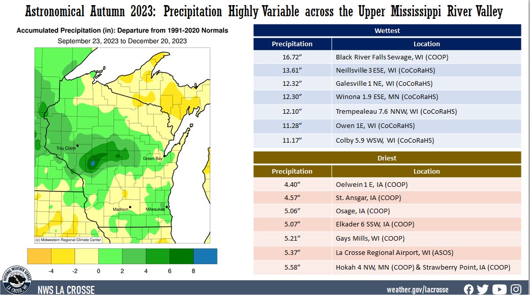 |
During autumn, moderate (D1) to extreme (D3) drought improved from 99.85% to 64.9% of the La Crosse Hydrologic Service Area (HSA). Extreme (D3) drought improved from 41.9% to 20.1% of the HSA.
Snowfall:
|
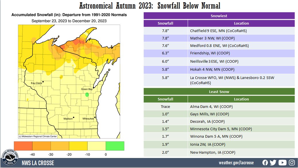
Autumn snowfall ranged trace at Alma Dam 4, WI (COOP) to 7.8" at Chatfield 9 ESE, MN (CoCoRaHS). These values were up to 10 inches below normal. The snowiest day was 3.9" at Lanesboro 0.2 SSW, MN (CoCoRaHS) from 7 AM on October 31 to 7 AM on November 1. |
 |
The information below details astronomical autumn 2023 temperatures, precipitation, and snowfall for La Crosse WI, and Rochester MN.
The astronomical Autumn of 2023 was warmer and drier than normal in La Crosse, WI. More details can be found below.
Temperatures - 7th Warmest
|
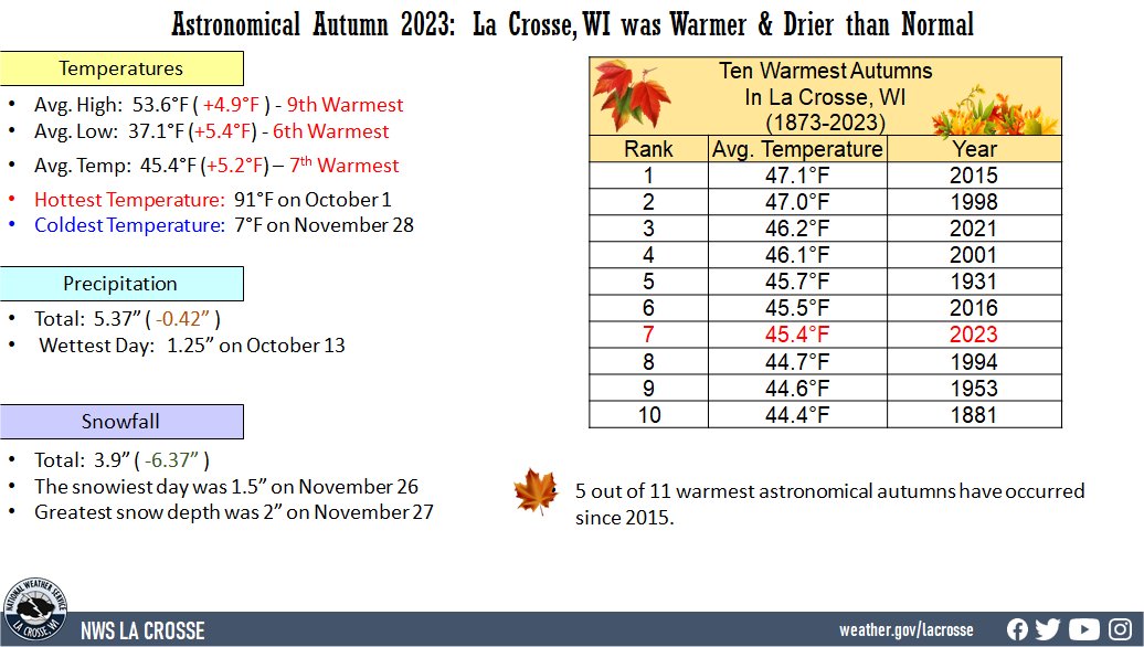 |
Ten Warmest Astronomical Autumns
in La Crosse, WI
1873-2023
Average
Rank Temperature Year
---- ----------- ----
1 47.1°F 2015
2 47.0°F 1998
3 46.2°F 2021
4 46.1°F 2001
5 45.7°F 1931
6 45.5°F 2016
7 45.4°F 2023
8 44.7°F 1994
9 44.6°F 1953
10 44.4°F 1881
The average high temperature was 53.6°F which was 4.9°F warmer than the 1873-2023 long-term average of 48.7°F. This was the 9th warmest and the warmest since 2021 (55.6°F - 3rd warmest).
The average low temperature was 37.1°F which was 5.4°F warmer than the 1873-2023 long-term average of 31.7°F. This was the 6th warmest and the warmest since 2015 (38.3°F - warmest).
The hottest high temperature was 91°F on October 1.
The coldest high temperature was 24°F on November 27 and November 28.
The warmest low temperature was 68°F on September 30 and October 1.
The coldest low temperature was 7°F on November 28.
Precipitation - Drier than Average
Snowfall - Below Average
Snow Depth - Below Average
The astronomical Autumn of 2023 was warmer and wetter than normal at Rochester, MN. More details can be found below.
Temperatures - 6th Warmest
|
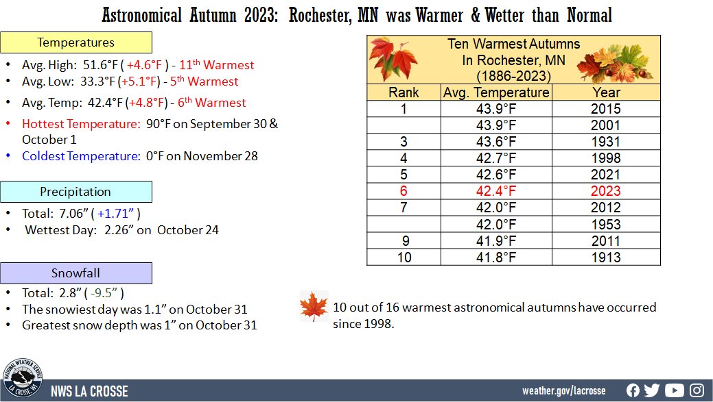 |
Ten Warmest Astronomical Autumns
in Rochester MN
1886-2023
Average
Rank Temperature Year
---- ----------- ----
1 43.9°F 2015
43.9°F 2001
3 43.6°F 1931
4 42.7°F 1998
5 42.6°F 2021
6 42.4°F 2023
7 42.0°F 2012
42.0°F 1953
9 41.9°F 2011
10 41.8°F 1913
The average high temperature was 51.6°F which was 4.6°F warmer than the 1886-2023 long-term average of 47°F. This was the 11th warmest and the warmest since 2021 (52°F - 8th warmest).
The average low temperature was 33.3°F which was 5.1°F warmer than the 1886-2023 long-term average of 28.2°F. This was tied for the 5th warmest with 2021.
The warmest high temperature was 90°F on September 30 and October 1.
The coldest high temperature was 19°F on November 27.
The warmest low temperature was 67°F on September 30.
The coldest low temperature was 0°F on November 28.
Precipitation - Wetter than Normal
Snowfall - 8th Least
Ten Least Amount of Snow
in Astronomical Autumn
in Rochester MN
1933-2023
Rank Snowfall Year
---- -------- ----
1 0.5 inches 1960
2 0.8 inches 1935
0.8 inches 1933
4 0.9 inches 1967
5 1.0 inch 2001
6 1.1 inches 1962
7 1.5 inches 1965
8 2.8 inches 2023
9 3.0 inches 1944
10 3.1 inches 2015
Snow Depth - Tied for Least with 11 Other Years

