Autumn 2021 was warmer and drier than normal across the Upper Mississippi River Valley. More specific details can be found below. This includes information for La Crosse WI and Rochester MN.
Temperatures...
|
During the meteorological autumn of 2021 (September 1-November 30), average temperatures ranged from near-normal to 6 degrees above normal across the Upper Mississippi River Valley. The highest average temperature was 54.5°F at La Crosse Regional Airport. Meanwhile, the coolest average temperature was 46.6°F at Medford Taylor County Airport. Typically autumn temperatures average from 44°F to 50°F. Rochester, MN tied 2005 and 2007 for their 4th warmest autumn (50.7°F). 11 out of their 21 warmest autumns have occurred since 1998. La Crosse, WI had their 5th warmest autumn (54.5°F). 9 out of their 16 warmest autumns have occurred since 1998. The hottest temperature was 91°F at Boscobel, WI, and Mondovi, WI on September 19. Meanwhile, the coldest temperature was 3°F at Black River Falls, WI on November 26. |
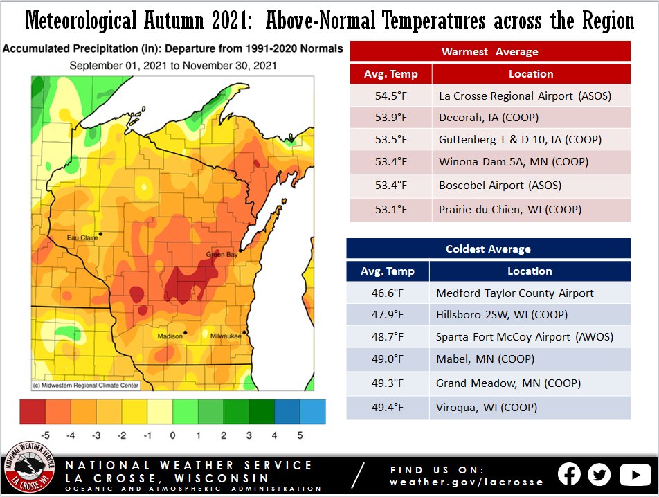 Autumn 2021 Temperature Anomalies |
Precipitation...
|
The autumn precipitation was drier than normal across the Upper Mississippi River Valley. Precipitation total ranged from 2.80" at Friendship, WI to 10.83" near Waucoma, IA. Normally, precipitation totals range from 7.50" to 8.50" south of Interstate 94 and 8.50" to 9.50" across the remainder of the area. Friendship, WI had its driest autumn (2.80"). The previous record was 4.15" in 1944. Precipitation records date back to 1930. Mather, WI had their 5th driest autumn (3.18"). Their driest autumn occurred in 1950 (2.27"). This autumn was their driest since 1953 (3.04" - 2nd driest). La Crosse, WI had their 15th driest (3.91") autumn and their driest since 1990. The autumn began abnormally dry (D0) across parts of southeast Minnesota. Southwest Wisconsin saw abnormally dry (D0) to moderate (D1) drought conditions and northeast Iowa saw abnormally dry (D0) to severe (D2) drought conditions. During the autumn, there were some small improvements across southeast Minnesota and northeast Iowa. Meanwhile, abnormally dry (D0) and moderate (D1) drought conditions developed across central and north-central Wisconsin.
|
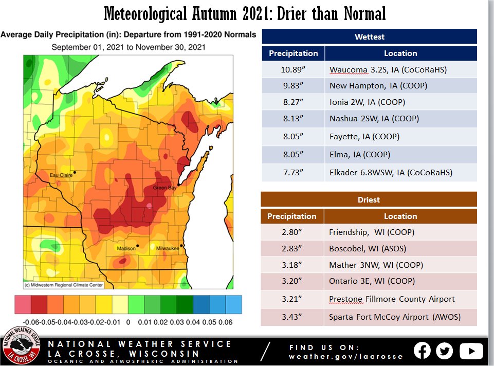 Autumn 2021 Precipitation Anomalies |
Snowfall...
| Snowfall was up to 2 to 6" below the 1991-2020 normal across the Upper Mississippi River Valley. Snowfall typically ranges from 2 to 5“ south of Interstate 90 and 5 to 8” across the remainder of the area. The highest snow total was 5.2” near Medford, WI. | 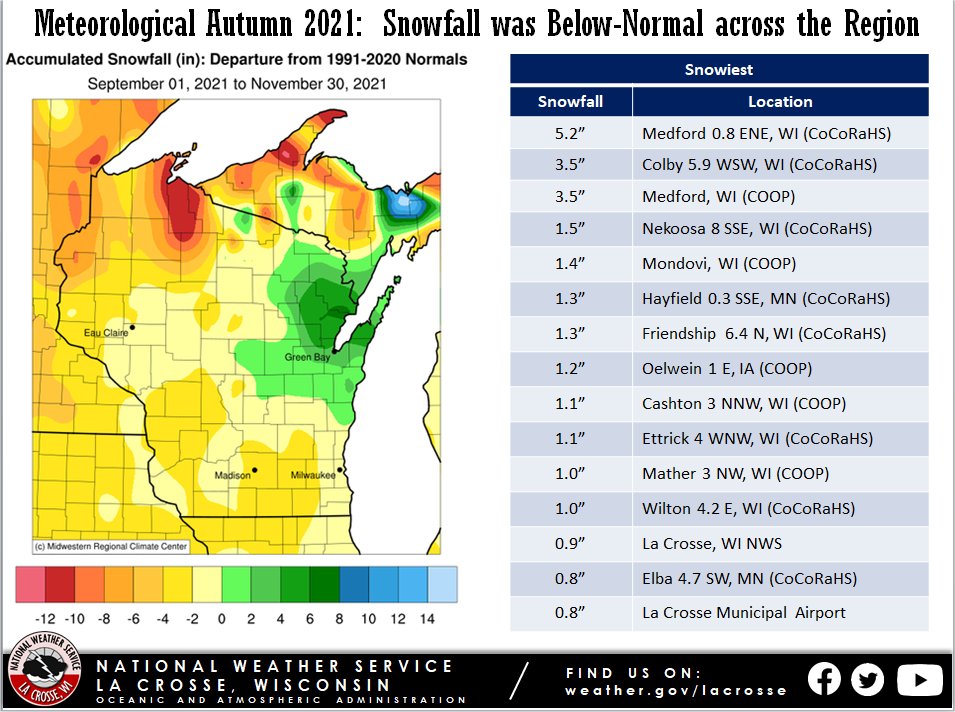 Autumn 2021 Snowfall Anomalies |
|
Temperatures...5th Warmest From September 1 through November 30, La Crosse Regional Airport had an average temperature of 54.5°F. This was 3.1°F warmer than the 1991-2020 normal of 51.4°F. This was the 5th warmest meteorological autumn and the warmest since 2016 (average temperature 56.6°F - warmest autumn). |
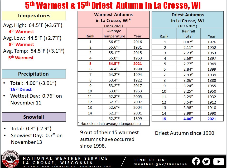 |
The table below contains the 10 warmest meteorological autumns.
Warmest Meteorological
Autumns in La Crosse WI
1873-2021
Rank Avg. Temp Year
---- --------- ----
1 56.6°F 2016
2 55.6°F 1931
3 55.1°F 2015
4 55.0°F 1963
5 54.5°F 2021
6 54.4°F 1998
7 54.2°F 1994
8 53.4°F 1922
9 53.2°F 2017
10 53.0°F 1953
The table below contains the monthly average temperatures and their departures from normal for the autumn of 2021.
Autumn 2021 Temperatures
in La Crosse WI
Average Departure
Month Temperature from Normal
----- ----------- -----------
September 67.2°F +2.4°F - Tied for
11th warmest
October 57.6°F +5.9°F - 5th warmest
November 38.7°F +1.1°F
Autumn 54.5°F +3.1°F - 5th warmest
Precipitation...15th Driest
From September 1 through November 30, La Crosse Regional Airport received 4.06 inches of precipitation. This was 3.91 inches drier than the 1991-2020 normal of 7.97 inches. This was the 15th driest meteorological autumn and the driest since 1990 (3.99 inches - 14th driest). The table below contains the 20 driest meteorological autumns.
Driest Meteorological
Autumns in La Crosse WI
1873-2021
Rank Precipitation Year
---- ------------- ----
1 0.82 inches 1976
2 2.11 inches 1952
3 2.23 inches 1953
4 2.69 inches 1897
5 2.77 inches 1949
6 2.84 inches 1899
7 2.93 inches 1939
8 3.06 inches 1888
9 3.24 inches 1955
10 3.25 inches 1950
11 3.29 inches 1932
12 3.54 inches 1912
13 3.98 inches 1910
14 3.99 inches 1990
15 4.06 inches 2021
16 4.08 inches 1967
17 4.12 inches 1993
18 4.23 inches 1893
19 4.30 inches 1918
20 4.40 inches 1895
The table below contains the monthly precipitation totals and their departures from normal for the autumn of 2021.
Autumn 2021 Precipitation
in La Crosse WI
Precipitation Departure
Month Total from Normal
----- ------------- -----------
September 1.43 inches -2.20 inches
October 1.05 inches -1.44 inches
November 1.58 inches -0.27 inches
Autumn 4.06 inches -3.91 inches - 15th Driest
Breakdown by precipitation amounts
None 58 Days
Trace 14 Days
0.01-0.09 inches 10 Days
0.10-0.24 inches 4 Days
0.25-0.49 inches 2 Days
0.50-0.99 inches 3 Days
Snowfall...Below-Normal
From September 1 through November 30, the official snow observer near La Crosse Regional Airport received 0.8 inches of snow. This was 2.9 inches below the 1991-2020 normal of 3.7 inches. The table below contains the monthly snowfall totals and their departures from normal for the autumn of 2021.
Autumn 2021 Snowfall
in La Crosse WI
Snowfall Departure
Month Total from Normal
----- ------------- -----------
September 0.0 inches 0.0 inches
October 0.0 inches -0.3 inches
November 0.8 inches -2.6 inches
Autumn 0.8 inches -2.9 inches
Breakdown by snowfall amounts
None 87 Days
Trace 2 Days
0.1-0.9 inches 2 Days
Sky...
Sea Level Pressure...
Winds...
|
Autumn of 2021 was much warmer and drier than normal at Rochester, MN. It was tied for the 4th warmest with 2005 and 2007. 14 out of their 25 warmest autumns have occurred since 1998. More details can be found below. Temperatures...Tied for the 4th Warmest with 2005 and 2007 From September 1 through November 30, Rochester International Airport had an average temperature of 50.7°F. This was 3.2°F warmer than the 1991-2020 normal of 47.5°F. This was tied for the 4th warmest meteorological autumn with 2005 and 2007, and the warmest since 2016 (average temperature of 53.1°F - the warmest meteorological autumn. |
|
The table below contains the 10 warmest meteorological autumns.
Warmest Meteorological
Autumns in Rochester MN
1886-2021
Rank Avg. Temp Year
---- --------- ----
1 53.1°F 2016
2 52.6°F 1963
3 52.0°F 2015
4 50.7°F 2021
50.7°F 2007
50.7°F 2005
7 50.5°F 1953
8 50.3°F 2011
9 50.1°F 1998
10 50.0°F 2001
50.0°F 1994
50.0°F 1948
The table below contains the monthly average temperatures and their departures from normal for the autumn of 2021.
Autumn 2021 Temperatures
in Rochester MN
Average Departure
Month Temperature from Normal
----- ----------- -----------
September 63.1°F +2.0°F
October 53.4°F +5.5°F - 10th Warmest
November 35.5°F +1.9°F
Autumn 50.7°F +3.2°F - Tied for 4th Warmest
Precipitation...Drier than normal
From September 1 through November 30, Rochester International Airport received 5.15 inches of precipitation. This was 2.68 inches drier than the 1991-2020 normal of 7.83 inches. The table below contains the monthly precipitation totals and their departures from normal for the autumn of 2021.
Autumn 2021 Precipitation
in Rochester, MN
Precipitation Departure
Month Total from Normal
----- ------------- -----------
September 1.63 inches -1.97 inches
October 1.63 inches -0.80 inches
November 1.89 inches +0.09 inches
Autumn 5.15 inches -2.68 inches
Breakdown by precipitation amounts
None 59 Days
Trace 10 Days
0.01-0.09 inches 14 Days
0.10-0.24 inches 1 Day
0.25-0.49 inches 4 Days
0.50-0.99 inches 1 Day
1.00-1.99 inches 1 Day
Snowfall...Tied for 12th Least with 1933
From September 1 through November 30, the official snow observer near Rochester International Airport received 0.6 inches of snow. This was 4.8 inches below the 1991-2020 normal of 5.4 inches. This was tied with 1933 for the 12th least amount of snow in autumn. The table below contains the 20 autumns with the least amount of snow.
Snowless Meteorological
Autumns in Rochester MN
1933-2021
Rank Total Snow Year
---- ---------- ----
1 Trace 1941
2 0.1 inches 2012
0.1 inches 1960
4 0.2 inches 2011
5 0.3 inches 1973
0.3 inches 1963
7 0.4 inches 2001
0.4 inches 1962
9 0.5 inches 1999
0.5 inches 1967
0.5 inches 1935
12 0.6 inches 2021
0.6 inches 1933
14 0.7 inches 1998
0.7 inches 1980
0.7 inches 1958
17 0.9 inches 2007
18 1.0 inches 2016
19 1.1 inches 1965
20 1.3 inches 2013
1.3 inches 2010
1.3 inches 2003
1.3 inches 1948
The table below contains the monthly snowfall totals and their departures from normal for the autumn of 2021.
Autumn 2021 Snowfall
in Rochester MN
Snowfall Departure
Month Total from Normal
----- ------------- -----------
September 0.0 inches 0.0 inches
October 0.0 inches -0.9 inches
November 0.6 inches -3.9 inches - Tied for 19th Least
Autumn 0.6 inches -4.8 inches - Tied for 12th Least
Breakdown by snowfall amounts
None 84 Days
Trace 5 Days
0.1-0.9 inches 2 Days
Sky...
Sea Level Pressure...
Winds...

