National Weather Service United States Department of Commerce

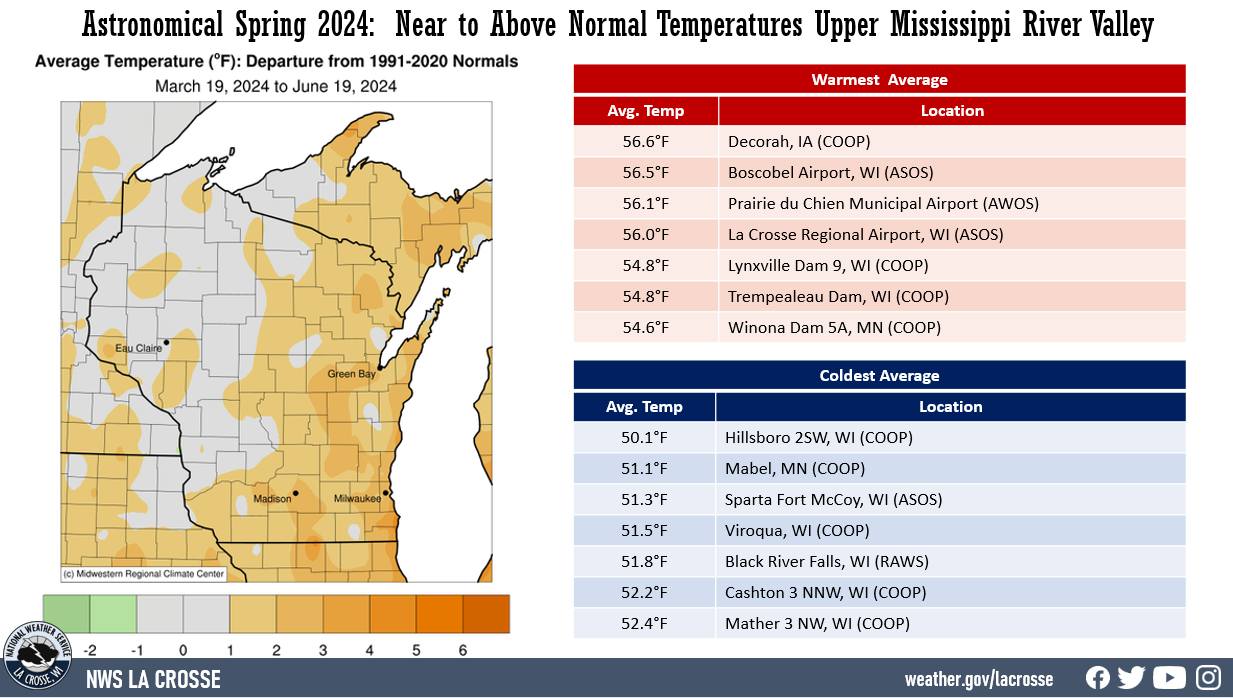
Upper Mississippi River Climate Summary for Astronomical Spring 2024:


Temperatures - Near to Above Normal Temperatures

 
  • During the 2024 astronomical spring (March 19 through June 19), average temperatures ranged from 50.1°F near Hillsboro, WI (COOP) to 56.6°F at Decorah, IA (COOP).
  • Temperature anomalies ranged from near-normal to 3°F above normal.
  • There was a 91°F difference between the warmest and coldest temperatures in the Upper Mississippi River Valley. The warmest temperature was 92°F at Boscobel Airport, WI (ASOS) on June 18. Meanwhile, the coldest temperature was 1°F at Mondovi, WI on March 23.
Astronomical Spring 2024 Temperature Summary

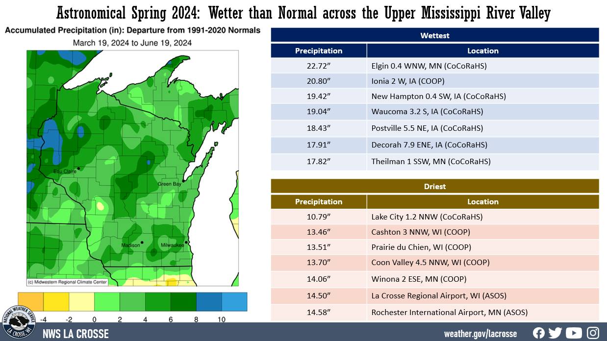
Precipitation - Wetter than Normal

  • Precipitation totals varied from 10.79" near Lake City, MN (CoCoRaHS) to 22.72" near Elgin, MN (CoCoRaHS).
  • Precipitation anomalies were up to 8" wetter than normal.
  • The highest one-day precipitation was 3.72" at Decorah Municipal Airport, IA (AWOS) on May 21.
  • At the beginning of the spring, 82% of the La Crosse Hydrologic Service Area (HSA) was in drought. Severe (D2) and extreme (D3) drought covered much of northeast Iowa. Well above-normal precipitation during April and May, alleviated the drought across the entire area.
Astronomical Spring 2022 Precipitation Summary

Snowfall - Highly Variable

  • Spring snowfall varied from 2" at Prairie du Chien, WI (COOP) to 24.9" at the La Crosse National Weather Service on top of La Crosse Ridge.
  • Snowfall anomalies ranged from 4" below normal to 16" above normal. 
  • The highest one-day snowfall was 11.8" at NWS La Crosse, WI on April 2.
Astronomical Spring 2024 Snow Summary


Below are the climate summaries for the 2024 astronomical spring in La Crosse, WI, and Rochester, MN

La Crosse, WI


 Astronomical Spring 2024 Summary for La Crosse WI 
 

During the astronomical spring of 2024, La Crosse Regional Airport was warmer (56°F or 1.4°F warmer than average) and wetter (14.50" or 4.25" wetter than average) than the long-term average (1873-2024). More details on these statistics can be found below.

Temperatures - Warmer than Average

  • From March 19 through June 19, La Crosse Regional Airport had an average temperature of 56°F.  This was 1.4°F warmer than the long-term average of 54.6°F. This made it the 10th consecutive spring to average warmer than average. This includes the 5th warmest (2021), 12th warmest (2017), 21st warmest (2023), and the 24th warmest (2015).
  • The average high temperature was 66.4°F. This was 1.7°F warmer than the long-term average of 64.7°F. 
  • The average low temperature was 45.5°F. This was 1°F warmer than the long-term average of 44.5°F. 
Astronomical Spring 2024 Climate Summary for La Crosse, WI
  • The warmest high temperature was 91°F on June 18. 
  • The coldest high temperature was 34°F on March 22.
  • The warmest low temperature was 70°F on June 18.
  • The coldest low temperature was 16°F on March 23.
  • There were 2 days in which the high temperature reached or exceeded 90°F. The long-term average is 2 days.
  • There were 16 days in which the low temperature was 32°F or colder. The long-term average is 17 days.  
     

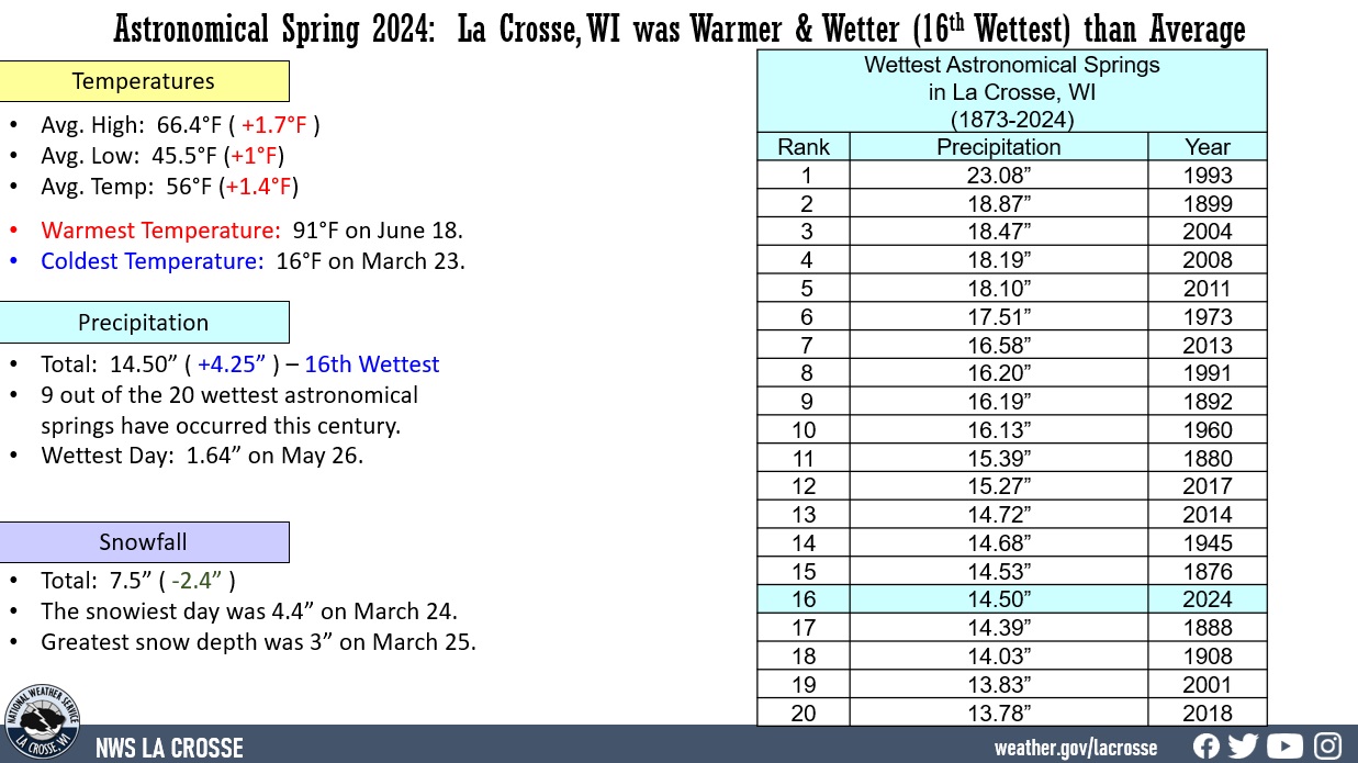
Precipitation - 16th Wettest

  • From March 19 through June 19, La Crosse Regional Airport received 14.50" of precipitation.
  • 9 out of the 20 wettest astronomical springs have occurred this century.
  • This was 4.25" wetter than the long-term average of 10.25".
  • This was the 16th wettest astronomical spring.
  • Here are the 20 wettest astronomical springs in La Crosse, WI.

 Wettest Astronomical Spring
      in La Crosse, WI
          1873-2024

        Precipitation
Rank        Total        Year
----    -------------    ----
  1     23.08 inches     1993
  2     18.87 inches     1899
  3     18.47 inches     2004
  4     18.19 inches     2008
  5     18.10 inches     2011
  6     17.51 inches     1973
  7     16.58 inches     2013
  8     16.20 inches     1991
  9     16.19 inches     1892
 10     16.13 inches     1960
 11     15.39 inches     1880
 12     15.27 inches     2017
 13     14.72 inches     2014
 14     14.68 inches     1945
 15     14.53 inches     1876
 16     14.50 inches     2024
 17     14.39 inches     1888
 18     14.03 inches     1908
 19     13.83 inches     2001
 20     13.78 inches     2018

  • Measurable precipitation (0.01" or greater) fell on 43 days (46.2%) and a trace of precipitation fell on 15 days (16.1%).  Number of days with...​

​None              35 days (37.6%)
Trace             15 days (16.1%)
0.01-0.09 inches   9 days ( 9.7%)
0.10-0.24 inches  12 days (12.9%)
0.25-0.49 inches  10 days (10.8%)
0.50-0.99 inches  10 days (10.8%)
1.00-1.99 inches   2 days ( 2.2%)

  • The wettest spring day was 1.64" on May 26. 
     

Snowfall - Above Average

  • From March 19 through June 19, the snow observer near La Crosse Regional Airport measured 7.5" of snow.  This was 2.4" above the long-term average of 5.1". This was the 26th snowiest astronomical spring.
  • Measurable snow (0.1" or greater) fell on 3 days (3.2%) and a trace of snow fell on 8 other days (8.6%).
  • Number of days with...

No snow       82 Days (88.2%)
Trace          8 Days  (8.6%)
0.1-0.9 inches 0 Days  (0.0%) 
1.0-2.9 inches 2 Days  (0.7%)
3.0-5.9 inches 1 Days  (2.2%)
6.0-8.9 inches 0 Days  (1.1%)    
 

  • The snowiest day was 4.4 inches of snow on March 24. 

Snow Depth - Average 

From March 19 through June 19, the average snow depth near La Crosse Regional Airport was 0.1 inches. This was the same as the long-term average of 0.1 inches.

The greatest snow depth was 3 inches on March 25.

Number of days with...

No snow       86 Days (92.5%)
Trace          3 Days  (3.2%)
1-3 inches     4 Days  (4.3%) 
4-6 inches     0 Days  (0.0%)

Snow Depth 

  • The average snow depth near La Crosse Regional Airport was 0.1". This was the same as the long-term average of 0.1".
  • The greatest snow depth was 3" on March 25.
  • Number of days with...

No snow       86 Days (92.5%)
Trace          3 Days  (3.2%)
1-3 inches     4 Days  (4.3%) 
4-6 inches     0 Days  (0.0%)


Rochester, MN  
 

Astronomical Spring 2024 Summary for Rochester MN


During the astronomical spring of 2024, temperatures averaged warmer than average (53.2°F or 1°F warmer than average) and wetter than average (14.58" or 4.19" wetter than average) at Rochester International Airport. More details on these statistics can be found below.

Temperatures - Warmer than Average

  • From March 19 through June 19, Rochester International Airport had an average temperature of 53.2°F. This was 1°F warmer than the long-term average of 52.2°F.  
  • The average high temperature was 63.5°F. This was 0.7°F warmer than the long-term average of 62.8°F.  
  • The average low temperature was 42.8°F. This was 1.2°F warmer than the long-term average of 41.6°F. 
Astronomical Spring 2024 Climate Summary for Rochester, MN
  • The warmest high temperature was 88°F on May 18. 
  • The coldest high temperature was 30°F on March 22.
  • The warmest low temperature was 68°F on June 18.
  • The coldest low temperature was 12°F on March 23.
  • There were 0 days in which the high temperature reached or exceeded 90°F. The long-term average is 2 days.
  • There were 23 days in which the low temperature was 32°F or colder. The long-term average is 24 days.

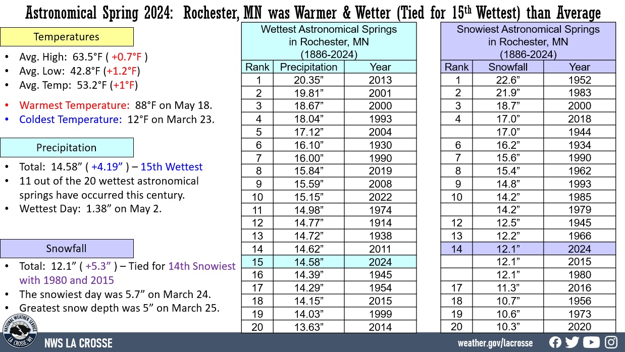
Precipitation - 15th Wettest Spring

  • Rochester International Airport received 14.58" of precipitation.
  • This was 4.19" wetter than the long-term average of 10.39".
  • This made it the 15th wettest astronomical spring.
  • 11 out of the 20 wettest astronomical springs have occurred this century.
  • Here are the 20 wettest astronomical springs in Rochester, MN.

 Wettest Astronomical Spring
      in Rochester, MN
         1886-2024

        Precipitation
Rank        Total        Year
----    -------------    ----
  1     20.35 inches     2013
  2     19.81 inches     2001
  3     18.67 inches     2000
  4     18.04 inches     1993
  5     17.12 inches     2004
  6     16.10 inches     1930
  7     16.00 inches     1990
  8     15.84 inches     2019
  9     15.59 inches     2008
 10     15.15 inches     2022
 11     14.98 inches     1974
 12     14.77 inches     1914
 13     14.72 inches     1938
 14     14.62 inches     2011
 15     14.58 inches     2024
 16     14.39 inches     1945
 17     14.29 inches     1954
 18     14.15 inches     2015
 19     14.03 inches     1999
 20     13.63 inches     2014

  • Measurable precipitation (0.01 inches or greater) fell on 46 days (49.5%) and a trace of precipitation fell on 10 days (10.8%).  
  • Number of days with...

None              37 days (39.8%)
Trace             10 days (10.8%)
0.01-0.09 inches  19 days (20.4%)
0.10-0.24 inches   5 days ( 5.4%)
0.25-0.49 inches   6 days ( 6.5%)
0.50-0.99 inches  15 days (16.1%)
1.00-1.99 inches   1 day  ( 1.1%) 

  • The wettest spring day was 1.38" on May 2. 

Snowfall - Tied for 14th Snowiest with 1980 and 2015

  • From March 19 through June 19, the snow observer near Rochester International Airport measured 12.1" of snow.  
  • This was 5.3" snowier than the long-term average of 6.8".
  • This was tied for the 14th snowiest astronomical spring in 1980 and 2015.  
  • Here are the 20 snowiest astronomical springs in La Crosse, WI.

 Snowiest Astronomical Spring
      in Rochester, MN
         1886-2024

          Snowfall
Rank        Total        Year
----    -------------    ----
  1      22.6 inches     1952
  2      21.9 inches     1983
  3      18.7 inches     2000
  4      17.0 inches     2018
         17.0 inches     1944
  6      16.2 inches     1934
  7      15.6 inches     1988
  8      15.4 inches     1962
  9      14.8 inches     1993
 10      14.2 inches     1985
         14.2 inches     1979
 12      12.5 inches     1945
 13      12.2 inches     1966
 14      12.1 inches     2024
         12.1 inches     2015
         12.1 inches     1980
 17      11.3 inches     2016
 18      10.7 inches     1956
 19      10.6 inches     1973
 20      10.3 inches     2020

  • Measurable snow (0.1 inches or greater) fell on 8 days (8.6%) and a trace of precipitation fell on 1 day (1.1%). 
  • Number of days with...

No snow           84 Days (90.3%)
Trace              1 Day  ( 1.1%)
0.1-0.9 inches     5 Days ( 5.4%)
1.0-2.9 inches     2 Days ( 2.2%) 
3.0 to 5.9 inches  1 Day  ( 1.1%)

  • The snowiest day was 5.7" on March 24.

Snow Depth - Less than Average

  • From March 19 through June 19, the average snow depth near Rochester International Airport was 0.1".  
  • This was 0.2" below the long-term average of 0.3".
  • Number of days with...

No snow       86 Days (92.5%)
Trace          0 Days ( 0.0%)
1-3 inches     6 Days ( 6.5%)
4-6 inches     1 Day  ( 1.1%)

  • The greatest snow depth was 5" on March 25.