Temperatures:
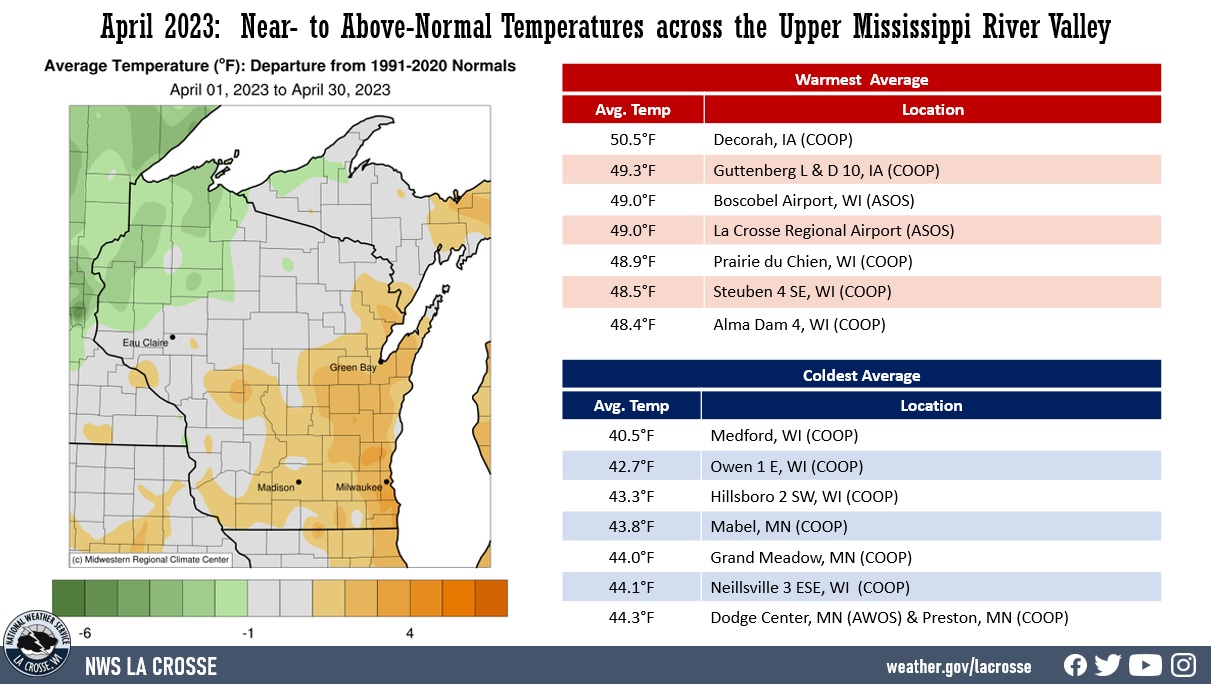
| During April 2023, temperature anomalies ranged from 1°F below normal to 3°F above normal across the Upper Mississippi River Valley. Monthly average temperatures ranged from 40.5°F at Medford, WI (COOP) to 50.5°F at Decorah, IA (COOP (ASOS). The hottest temperature was 90°F at Austin Municipal and La Crosse Regional (third earliest 90°F in a year) airports on April 12 and the coldest temperature was 14°F at Sparta Fort McCoy Airport on April 1. |
 |
Precipitation:
|
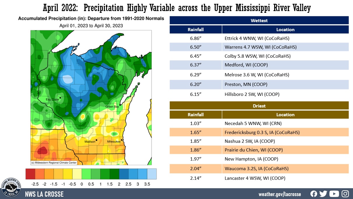
Precipitation anomalies ranged from near-normal to 3" drier than normal across northeast Iowa and southwest Wisconsin, and from near-normal to 3.5" wetter-than-normal across the remainder of the area. Precipitation totals ranged from 1.03" near Necedah, WI (CRN) to 6.86" near Ettrick, WI. The greatest 1-day rainfall was 2.74" near Owen, WI (COOP). This precipitation fell from 7 AM on April 17 to 7 AM on April 18.
|
 |
|
During the month, there were 5 Severe Thunderstorm Warnings. This was below the 1986-2023 average of 9 severe weather warnings. The greatest number of severe weather warnings in April was 53 warnings (50 Severe Thunderstorm Warnings and 3 Tornado Warnings) in 2002.
|
Snowfall:
|
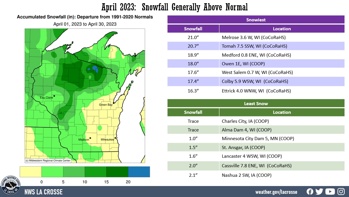
Snowfall anomalies were up to 20" above-normal. Snowfall totals ranged from a trace at Alma Dam 4, WI (COOP) and Charles City, IA (COOP) to 21" near Melrose, WI (CoCoRaHS). The snowiest day was 19.5" near Melrose, WI (CoCoRaHS) from 7 AM on April 16 to 7 AM on April 17.
|
 |
Below are the April 2023 climate summaries for La Crosse, WI, and Rochester, MN.
La Crosse, WI
April 2023 La Crosse, WI was Drier and Snowier than Normal with Normal Temperature
Temperatures - Normal
- The average temperature at La Crosse Regional Airport was 49°F. This was normal for the month of April. While the monthly average was normal, it was far from that. There were 12 days warmer than normal and 18 days colder than normal. The warmest stretch of days was April 10-14. Temperatures during that stretch averaged 71.2°F (23.8°F warmer than normal). This was tied with April 26-30, 1901 for the 5th warmest 5-day stretch in April. The warmest April 5-day stretch was 72.9°F from April 18 through April 22, 1985. There were 2 stretches of days that averaged 12 degrees colder than normal. They were April 16-18 (average 37.7°F) and April 21-25 (average 40.2°F).
|
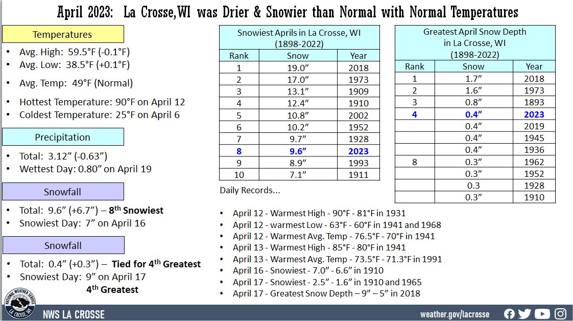 |
- The average high temperature was 59.5°F. This was slightly cooler (-0.1°F) than the 1991-2020 normal of 59.6°F.
- The average low temperature was 38.5°F. This was slightly warmer (+0.1°F) than the 1991-2020 normal of 38.4°F.
- The warmest high temperature was 90°F on April 12. This was only the 13th time that a 90°F or higher temperature was recorded in April. This was also the third earliest in a calendar year. Only 1991 (April 6 - 91°F) and 1930 (April 10 - 91°F).
- The coldest high temperature was 42°F on April 17.
- The warmest low temperature was 63°F on April 12.
- The coldest low temperature was 25°F on April 6.
- The low temperature was 32°F or colder on 11 days. This was slightly greater than 1873-2023 average of 9 days.
Precipitation - Drier-than-Normal
- A total of 3.12" of precipitation fell. This was 0.63" drier than the 1991-2020 normal of 3.75". This ended a stretch of 5 consecutive months with above-normal precipitation. The last time a month saw below-normal precipitation was October 2022.
- The wettest calendar day was 0.80" on April 19.
- Measurable precipitation fell on 13 days and a trace on 1 day.
Snowfall - 8th Snowiest
- A total of 9.6 inches of snow fell. This was 6.7" snowier than the 1991-2020 normal of 2.9". This was the 8th snowiest April and the snowiest since 2018 (snowiest April - 19"). The following table lists the 10 snowiest Aprils in La Crosse, WI.
Snowiest Aprils
in La Crosse, WI
1897-2023
Rank Snowfall Year
---- -------- ----
1 19.0 inches 2018
2 17.0 inches 1973
3 13.1 inches 1909
4 12.4 inches 1910
5 10.8 inches 2002
6 10.2 inches 1952
7 9.7 inches 1928
8 9.6 inches 2023
9 8.9 inches 1993
10 7.1 inches 1911
-
While the airport received 9.5 inches on April 16-17, other parts of La Crosse County saw much higher snow totals from that snowstorm. This includes 12.8 inches near Holmen, 14 inches in Onalaska, and 17.3 inches in West Salem. Hourly snow totals approached 3 inches an hour at times on Sunday.
-
The snowiest calendar day was 7 inches on April 16. This not only surpassed the record for the calendar day (the old record of 6.6 inches in 1910), but it was also the 3rd snowiest April calendar day. Only April 9, 1973 (10.3 inches) and April 13, 1952 (7.3 inches) were snowier.
-
Measurable snow fell on 3 days and trace amounts on 3 days.
Snow Depth - 4th Greatest
- The average snow depth was 0.4". This is 0.3" greater than the 1893-2023 long-term average of 0.1". This was tied with 1936, 1945, and 2019 for the 4th greatest in April. The greatest average snow depth since 2018 (greatest average April snow depth - 1.7 inches). The following table lists the 10 greatest April average snow depths in La Crosse, WI.
Greatest April
Avg. Snow Depth
in La Crosse, WI
1893-2023
Rank Snow Depth Year
---- ---------- ----
1 1.7 inches 2018
2 1.6 inches 1973
3 0.8 inches 1893
4 0.4 inches 2023
0.4 inches 2019
0.4 inches 1945
0.4 inches 1936
8 0.3 inches 1962
0.3 inches 1952
0.3 inches 1928
0.3 inches 1910
- The greatest snow depth was 9" on April 17. This not only surpassed the record for the calendar day (old record of 5" in 2018), but it was also the 4th greatest April snow depth for a calendar day. Only April 10, 1973 (16"); April 11, 1973 (12"); and April 9, 1952 (10") had a greater snow depth for a calendar day.
- No snow was on the ground for 26 days.
- Trace amounts of snow were on the ground for 2 days.
- Measurable snow was on the ground for 2 days.
Mississippi River Flooding - 3rd Highest Crest
- The Mississippi River at La Crosse, WI rose above its 12-foot flood stage shortly before 1 AM on April 17. This was the first time it had risen above flood stage since April 13, 2020. This 1,099 stretch of days below flood stage (10th longest) was the longest since a 1,108-day stretch from April 22, 2011, to May 3, 2014 (9th longest). The longest stretch of days below flood stage is a 3,986-day stretch from May 12, 1954, to April 9, 1965.
- The river then reached a moderate flood stage (13 feet) around 3 AM on April 18. This was the first time that it had reached this level since June 3, 2019. This 1,415-day stretch of days below 13 feet was the longest since a 1,727-day stretch of days from July 5, 2014, through March 27, 2019 (7th longest). The longest stretch of days below 13 feet is a 5,127-day stretch from April 2, 1937, to April 15, 1951.
- The river then climbed to a major flood stage (15.5 feet) for the first time since April 19, 2001, between 6 and 7 PM on April 23. This was the third longest stretch of days (8,039 days) below the major flood stage. The longest stretch of days is 13,137 days from April 29, 1965, through April 16, 2001. The river crested at 15.89 feet (3rd highest crest and the highest since a 16.41-foot crest on April 18, 2001 - 2nd highest) around 2 PM on April 26 and then began a slow fall. It fell below the major flood stage between 11 AM and noon on April 28. It was above the major flood stage for over 4 calendar days. This was the longest stretch of days since a 10-day stretch from April 19-28, 1965. By the end of April, the river had fallen to 14.45 feet.
...Records...
Daily Precipitation...
- April 12 - Warmest High - 90°F - 81°F in 1931
- April 12 - warmest Low - 63°F - 60°F in 1941 and 1968
- April 12 - Warmest Avg. Temp - 76.5°F - 70°F in 1941
- April 13 - Warmest High - 85°F - 80°F in 1941
- April 13 - Warmest Avg. Temp - 73.5°F - 71.3°F in 1991
- April 16 - Snowiest - 7.0" - 6.6" in 1910
- April 17 - Snowiest - 2.5" - 1.6" in 1910 and 1965
- April 17 - Greatest Snow Depth - 9" - 5" in 2018
...Looking ahead to May...
- The normal high temperature in La Crosse rises from 66°F on May 1st to 77°F by the end of the month. The normal low temperature warms from 45°F on the 1st to 56°F by the end of the month. The normal mean temperature for the month is 61°F. La Crosse's warmest May occurred in 1934 with an average temperature of 68°F, and their coldest May occurred in 1907 with an average temperature of 50.8°F.
- For May, the hottest temperature ever recorded was 107°F on May 31, 1934, and the coldest temperature was 26°F on May 2, 1911, May 3, 1971, and May 6, 1989.
- The average precipitation for May is 4.33". There are normally 5 days with thunderstorms during May in La Crosse. The wettest May occurred in 2004 with 9.73" of precipitation, while the driest was in 1887 with 0.50 of an inch. The wettest May day was 3.06" on May 19, 1912. Normally, there are 5 days with thunderstorms.
Rochester, MN
April 2023 - Rochester, MN was Drier and Snowier than Normal with Slightly Cooler than Normal Temperatures
Temperatures - Slightly Colder-than-Normal
-
The average temperature at Rochester International Airport was 45.1°F. This was slightly colder (-0.1°F) colder than the 1991-2020 normal of 45.2°F. While the average temperature was slightly below normal, temperatures were highly variable during the month. There were 18 days below normal, 1 day which was normal, and 11 days above normal. The warmest stretch of days was from April 10-14. The average temperature was 66.2°F or 22.4°F warmer than the 1991-2020 normal of 43.8°F. This was tied with April 15-19, 1977 for the warmest 5-day stretch in April. The warmest April 5-day stretch was 69.3°F from April 18-22, 1985. The coldest stretch of days was from April 21-25. The average temperature was 36.4°F or 11.9°F colder than the 1991-2020 normal of 43.8°F.
|
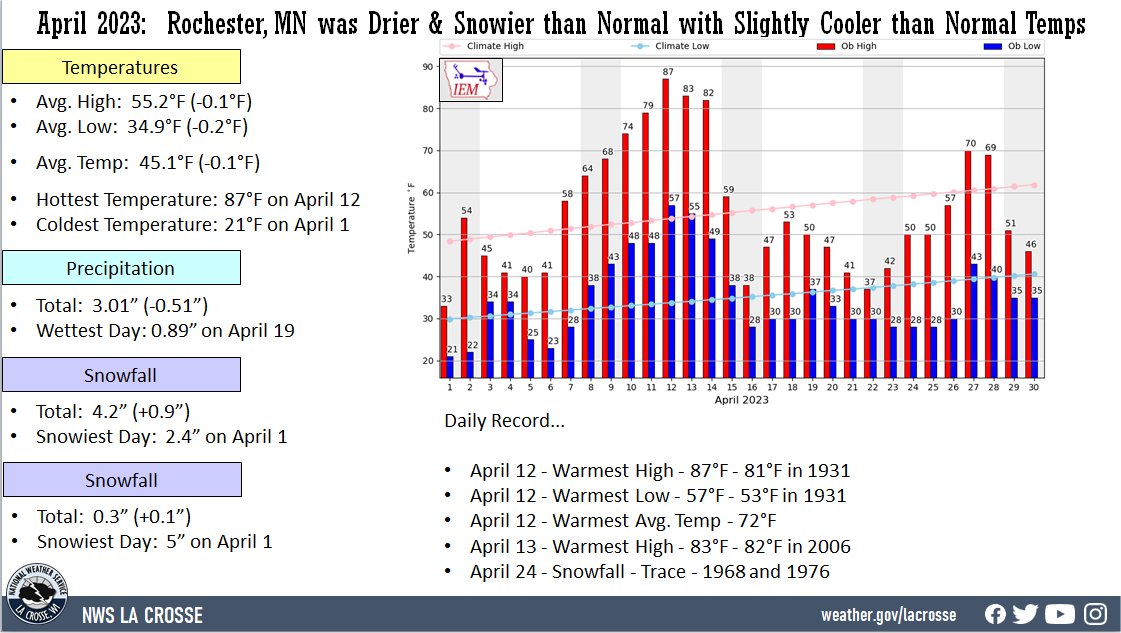 |
- The average high temperature was 55.2°F. This was slightly cooler (-0.1°F) than the 1991-2020 normal of 55.3°F.
- The average low temperature was 34.9°F. This was slightly colder (-0.2°F) than the 1991-2020 normal of 35.1°F.
- The warmest high temperature was 87°F on April 12. This was the warmest April temperature since April 24, 2009 (92°F).
- The coldest high temperature was 33°F on April 1.
- The warmest low temperature was 57°F on April 12.
- The coldest low temperature was 21°F on April 1.
Precipitation - Drier-than-Normal
-
A total of 3.01 inches of precipitation fell. This was 0.51" drier than the 1991-2020 normal of 3.52". This was the first month with below-normal precipitation since November 2022.
-
The wettest calendar day was 0.89" on April 19.
-
Measurable precipitation fell on 10 days and a trace on 7 days.
Snowfall...Above Normal
- A total of 4.2" of snow fell. This was 0.9" snowier than the 1991-2020 normal of 3.3".
- The snowiest calendar day was 2.4" on April 1.
- Measurable snow fell on 2 days and a trace on 6 days.
Snow Depth...Slightly More than the Long-Term Average
- The average snow depth was 0.3". This was 0.1" greater than the long-term average (1948-2023) of 0.2".
- The greatest snow depth was 5" on April 1.
- No snow was on the ground for 27 days.
- Measurable snow was on the ground for 3 days.
...Records...
- Daily Precipitation...
- April 12 - Warmest High - 87°F - 81°F in 1931
- April 12 - Warmest Low - 57°F - 53°F in 1931
- April 12 - Warmest Avg. Temp - 72°F
- April 13 - Warmest High - 83°F - 82°F in 2006
- April 24 - Snowfall - Trace - 1968 and 1976
...Looking ahead to May...
- The normal high temperature in Rochester rises from 62°F on May 1st to 74°F by the end of the month. The normal low temperature rises from 41°F on the 1st to 53°F by the end of the month. The normal mean temperature for the month is 57.6°F. Rochester’s warmest May occurred in 1934 with an average temperature of 66.2°F, and their coldest May occurred in 1888 with an average of only 49.6°F.
- For May, the hottest temperature ever recorded was 106°F on May 31, 1934, and the coldest temperature was 21°F on May 3 in 1910 and 1967. Normally, there is only 1 day with temperatures at or above 90°F.
- The average precipitation for the month of May is 4.35". The wettest May occurred in 2013 with 12.26" of precipitation. While the driest was in 1934 with 0.40 of an inch. The wettest May day was 4.02" on May 17, 2000. Normally, there are 5 days with thunderstorms.


 Weather Story
 Weather Map
 Local Radar