La Crosse, WI
Weather Forecast Office
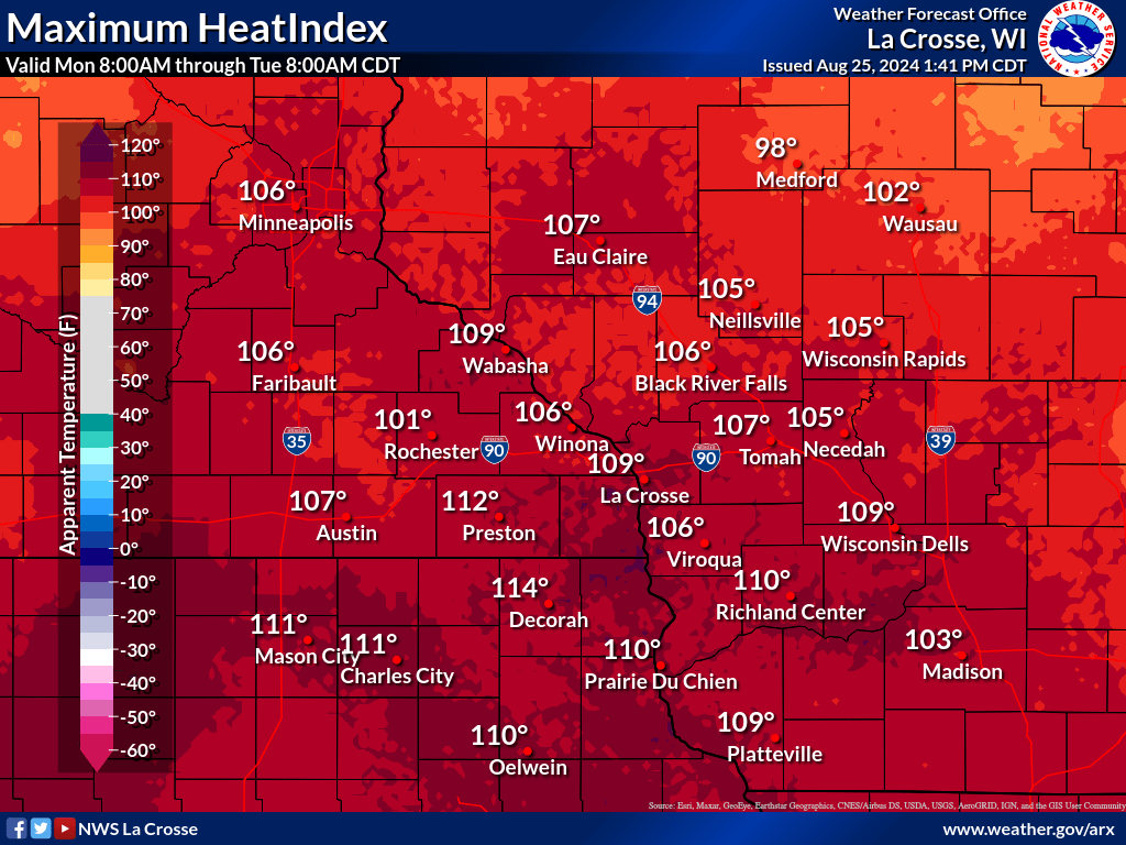
Hot and humid conditions expected today into Monday and depending on the storm progress, could last into Tuesday for some of the area. High temperatures are expected to be in the 80s and 90s with heat indices of 90 to 110 degrees. Overnight low temperatures tonight and Monday night will drop into the upper 60s and low 70s. A cold front will move across the area Tuesday and bring some relief to the heat. This front will be the focus for thunderstorms Monday night into Tuesday with some of the storms becoming severe. However, there is uncertainty in the timing and location of any storms. Therefore, please check back for further updates over the coming days.
    
Today & Mon: Heat Builds in This Weekend and Early Next Week
Mon Night - Tue: Strong to Severe Storm Potential
Additional Information:
|
• Submit Report • Severe Monitor Hazardous Weather Outlook Latest Weather Statement Storm Reports
Weather Story 
Radar |
Our Office
Staff
Want a tour?
Looking for a speaker?
Community Involvement
Station / Location Info
Follow Us On Social Media
Weather Safety
SkyWarn
Preparedness
Preparedness (En Espanol)
Weather Radio
StormReady
WRN Ambassadors
Additional Information
Storm Summaries
Cooperative Observers
Educational Resources
Science / Research
Weather Phenomenon
Mayfly Tracking
Latest
Temp/Pcpn Summary
Precipitation Reports
Forecast Discussion
Hazardous Weather Outlook
Hourly Weather
Public Information Statement
Local Storm Report
Lightning Plot Archive
River Stages
Water Temp
Observations
Precipitation Plotter
Soil Temps
US Dept of Commerce
National Oceanic and Atmospheric Administration
National Weather Service
La Crosse, WI
N2788 County Road FA
LaCrosse, WI 54601
608-784-7294
Comments? Questions? Please Contact Us.