|
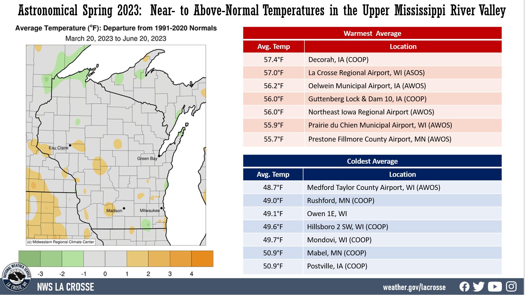
Spring Temperatures in the Upper Mississippi River Valley:
|
 |
|
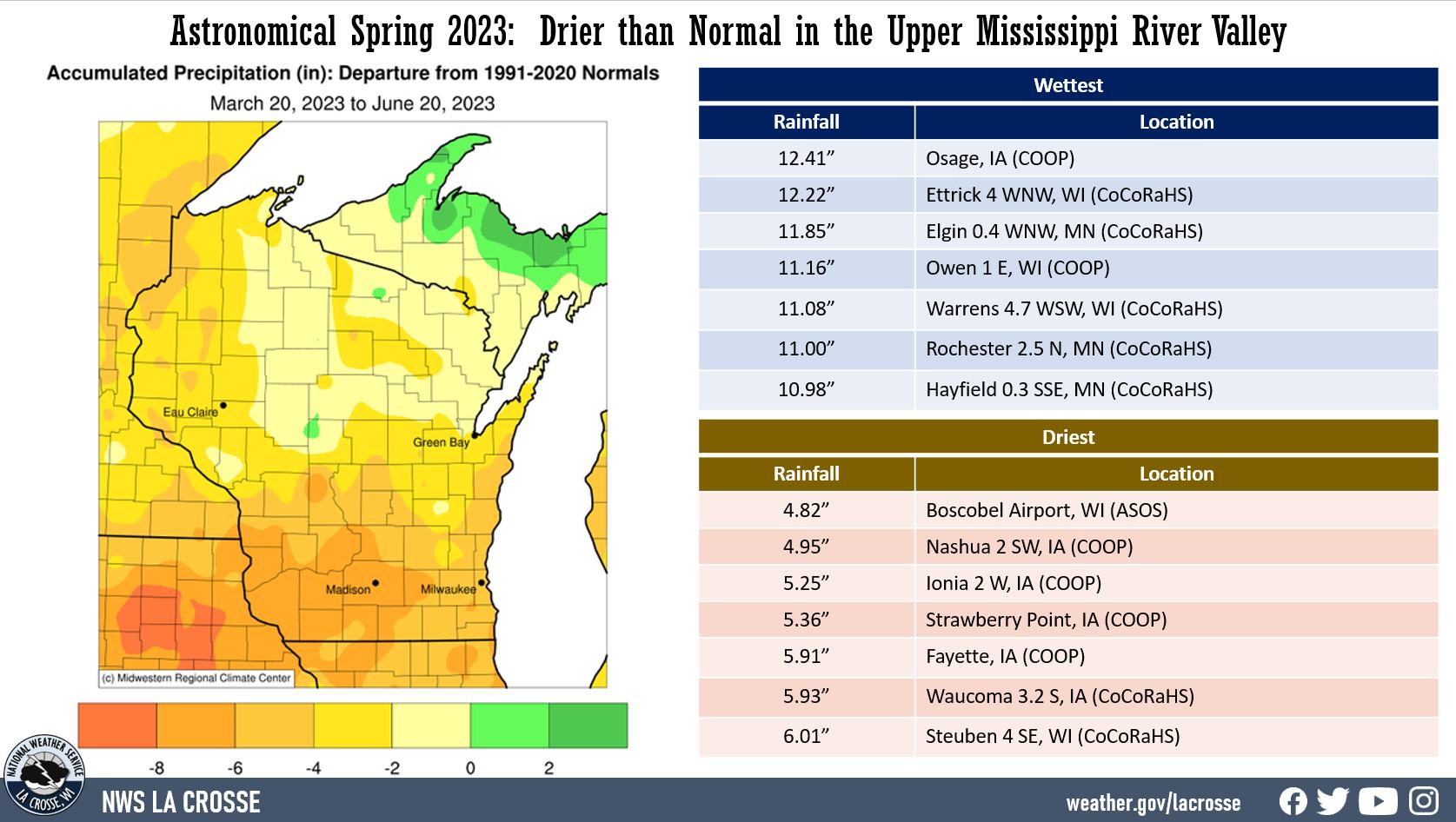
Spring Precipitation in the Upper Mississippi River Valley:
|
 |
|
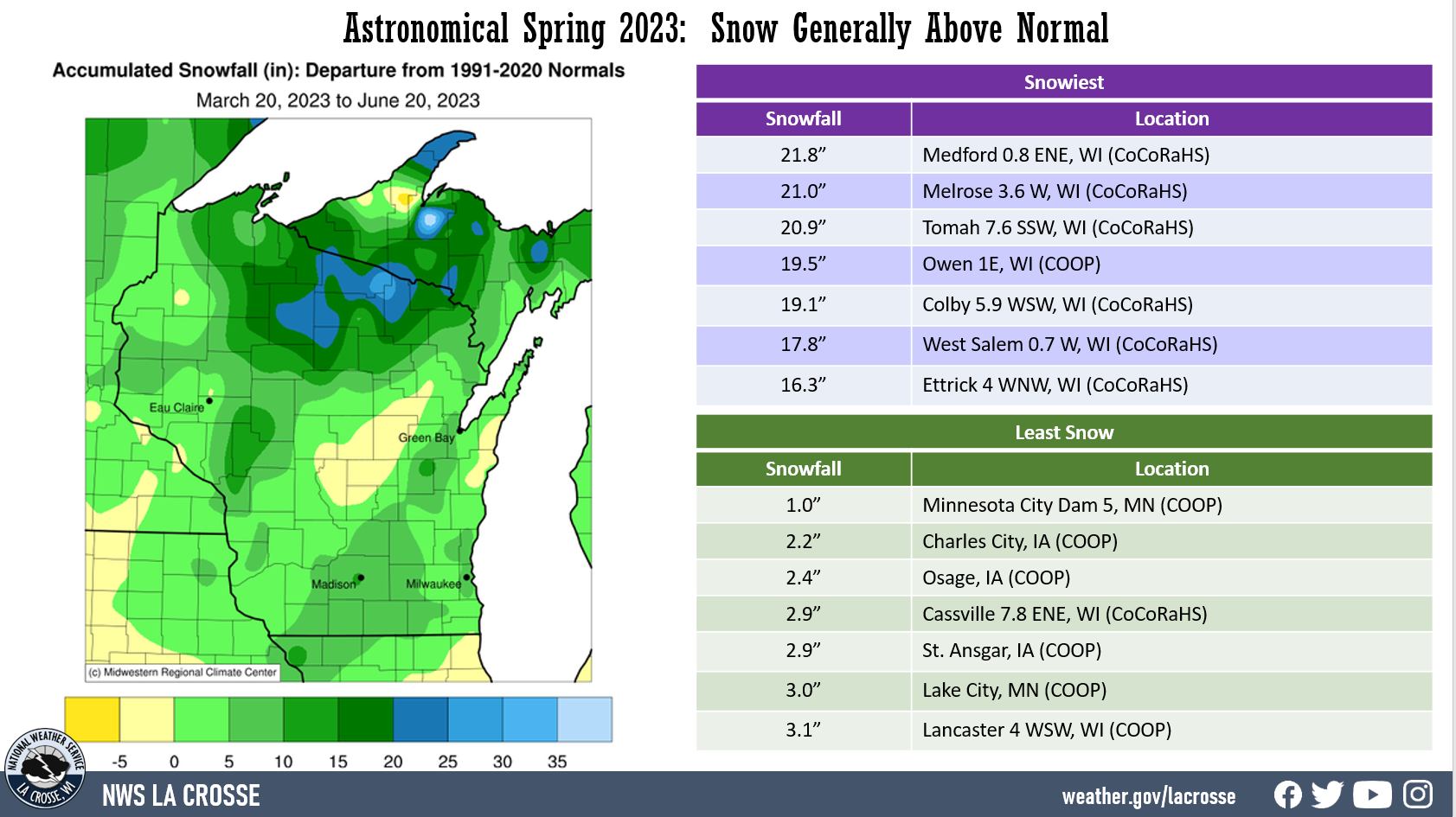
Spring Snowfall in the Upper Mississippi River Valley:
|
 |
Below are the astronomical spring summaries for La Crosse, WI, and Rochester, MN.
|
During the astronomical spring of 2023, La Crosse Regional Airport was warmer (57°F or 2.4°F warmer than average) and drier (8.72 inches or 1.51 inches drier than average) than the long-term average (1873-2023). More details on these statistics can be found below. Temperatures - Warmer than Average From March 20 through June 20, La Crosse Regional Airport had an average temperature of 57°F. This was 2.4°F warmer than the long-term average of 54.6°F. This was the 21st warmest astronomical spring. This made it the 9th consecutive spring to average warmer than average. This includes the 5th warmest (2021), 12th warmest (2017), 21st warmest (2023), and the 24th warmest (2015). |
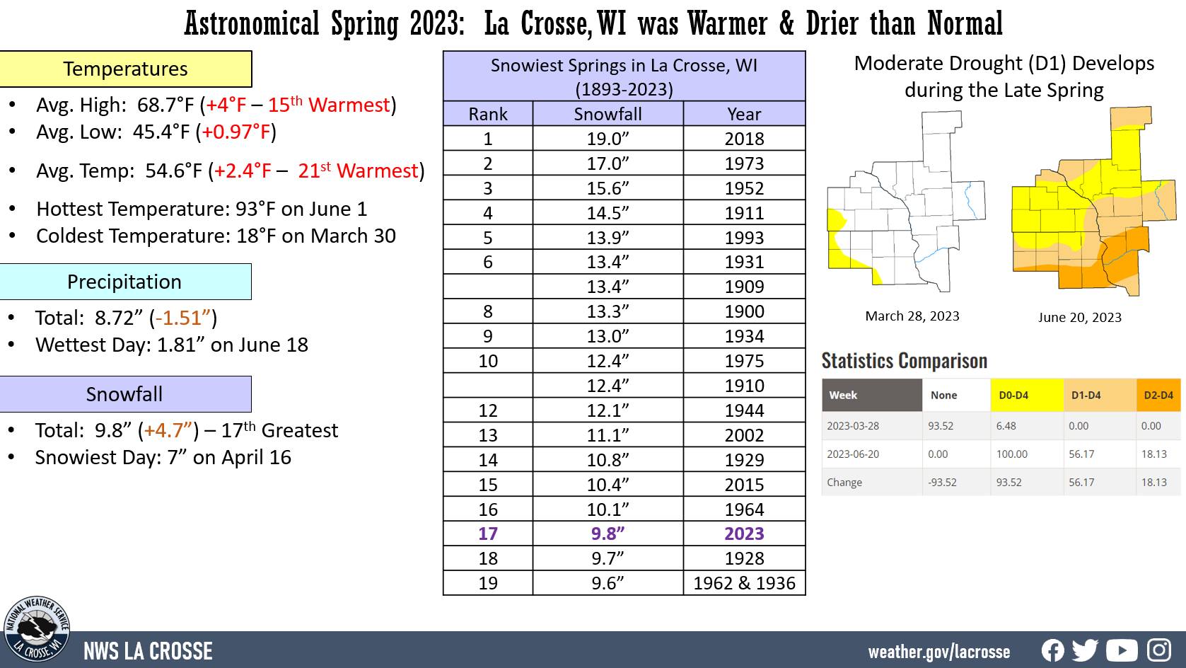 |
The average high temperature was 68.7°F. This was 4°F warmer than the long-term average of 64.7°F. This was the 15th warmest astronomical spring.
The average low temperature was 45.4°F. This was 0.9°F warmer than the long-term average of 44.5°F.
The warmest high temperature was 93°F on June 1.
The coldest high temperature was 35°F on March 29.
The warmest low temperature was 68°F on June 2.
The coldest low temperature was 18°F on March 30.
There were 8 days in which the high temperature reached or exceeded 90°F. The long-term average is 2 days.
There were 21 days in which the low temperature was 32°F or colder. The long-term average is 18 days.
Precipitation - Drier than Average
From March 20 through June 20, La Crosse Regional Airport received 8.72" of precipitation. This was 1.51" drier than the long-term average of 10.23". 2 out of 3 last springs have been drier than average. Prior to this, there were 10 consecutive wet springs (2011-2020).
The combination of anomalous snow in the basins that feed the Upper Mississippi River Valley and a cold March resulted in major flooding along the Upper Mississippi River Valley from mid-April to mid-May. The river above its 12 feet flood stage at La Crosse from April 16 through May 7. It crested at 15.89 feet on April 26. This was the 3rd highest crest. Only 1965 (17.89 feet) and 2001 (16.41 feet) were higher.
Through May 15, 6.52" of precipitation fell. This was 74.8% of the spring precipitation. Since that date, just 2.20" (most of that fell on June 18 - 1.18") has fallen. This was 25.2% of the seasonal total. The combination of above-normal temperatures and the lack of precipitation resulted in moderate (D1) drought developing in the county.
Measurable precipitation (0.01" or greater) fell on 29 days (31.2%) and a trace of precipitation fell on 4 days (4.3%).
Number of days with...
None 60 days (64.5%)
Trace 4 days ( 4.3%)
0.01-0.09 inches 12 days (12.9%)
0.10-0.24 inches 8 days ( 8.6%)
0.25-0.49 inches 3 days ( 3.2%)
0.50-0.99 inches 4 days ( 4.3%)
1.00-1.99 inches 2 days ( 2.2%)
The wettest spring day was 1.81 inches on June 18.
Snowfall - Above Average
From March 20 through June 20, the snow observer near La Crosse Regional Airport measured 9.8" of snow. This was 4.7" above the long-term average of 5.1". This was the 17 snowiest spring and the snowiest since 2018 (19" - snowiest astronomical spring).
20 Snowiest Astronomical Springs
in La Crosse, WI
1893-2023
Rank Snowfall Year
---- -------- ----
1 19.0 inches 2018
2 17.0 inches 1973
3 15.6 inches 1952
4 14.5 inches 1911
5 13.9 inches 1993
6 13.4 inches 1931
13.4 inches 1909
8 13.3 inches 1900
9 13.0 inches 1934
10 12.4 inches 1975
12.4 inches 1910
12 12.1 inches 1944
13 11.1 inches 2002
14 10.8 inches 1929
15 10.4 inches 2015
16 10.1 inches 1964
17 9.8 inches 2023
18 9.7 inches 1928
19 9.6 inches 1962
9.6 inches 1936
Measurable snow (0.1" or greater) fell on 4 days (4.3%) and a trace of snow fell on 5 other days (5.4%).
Number of days with...
No snow 84 Days (90.3%)
Trace 5 Days (5.4%)
0.1-0.9 inches 2 Days (2.2%)
1.0-2.9 inches 1 Day (1.1%)
3.0-5.9 inches 0 Days (0.0%)
6.0-8.9 inches 1 Day (1.1%)
The snowiest day was 7" of snow on April 16. While the airport received 9.5" on April 16-17, other parts of La Crosse County saw much higher snow totals from that snowstorm. This includes 12.8" near Holmen, 14" in Onalaska, and 17.3" in West Salem. Hourly snow totals approached 3" an hour at times on Sunday afternoon.
Snow Depth - Average
From March 20 through June 20, the average snow depth near La Crosse Regional Airport was 0.1". This was the same as the long-term average of 0.1".
The greatest snow depth was 9 inches on April 17.
Number of days with...
No snow 88 Days (94.6%)
Trace 2 Days (2.2%)
1-3 inches 3 Days (3.2%)
4-6 inches 0 Days (0.0%)
7-9 inches 1 Day (1.1%)
|
During the astronomical spring of 2023, temperatures averaged warmer than average (53.8°F or 1.6°F warmer than average) and it was slightly drier than average (10.30 inches or 0.05 inches drier than average) at Rochester International Airport. More details on these statistics can be found below. Temperatures - Warmer than Average From March 20 through June 20, Rochester International Airport had an average temperature of 53.8°F. This was 1.6°F warmer than the long-term average of 52.2°F. The average high temperature was 64.6°F. This was 1.8°F warmer than the long-term average of 62.8°F. |
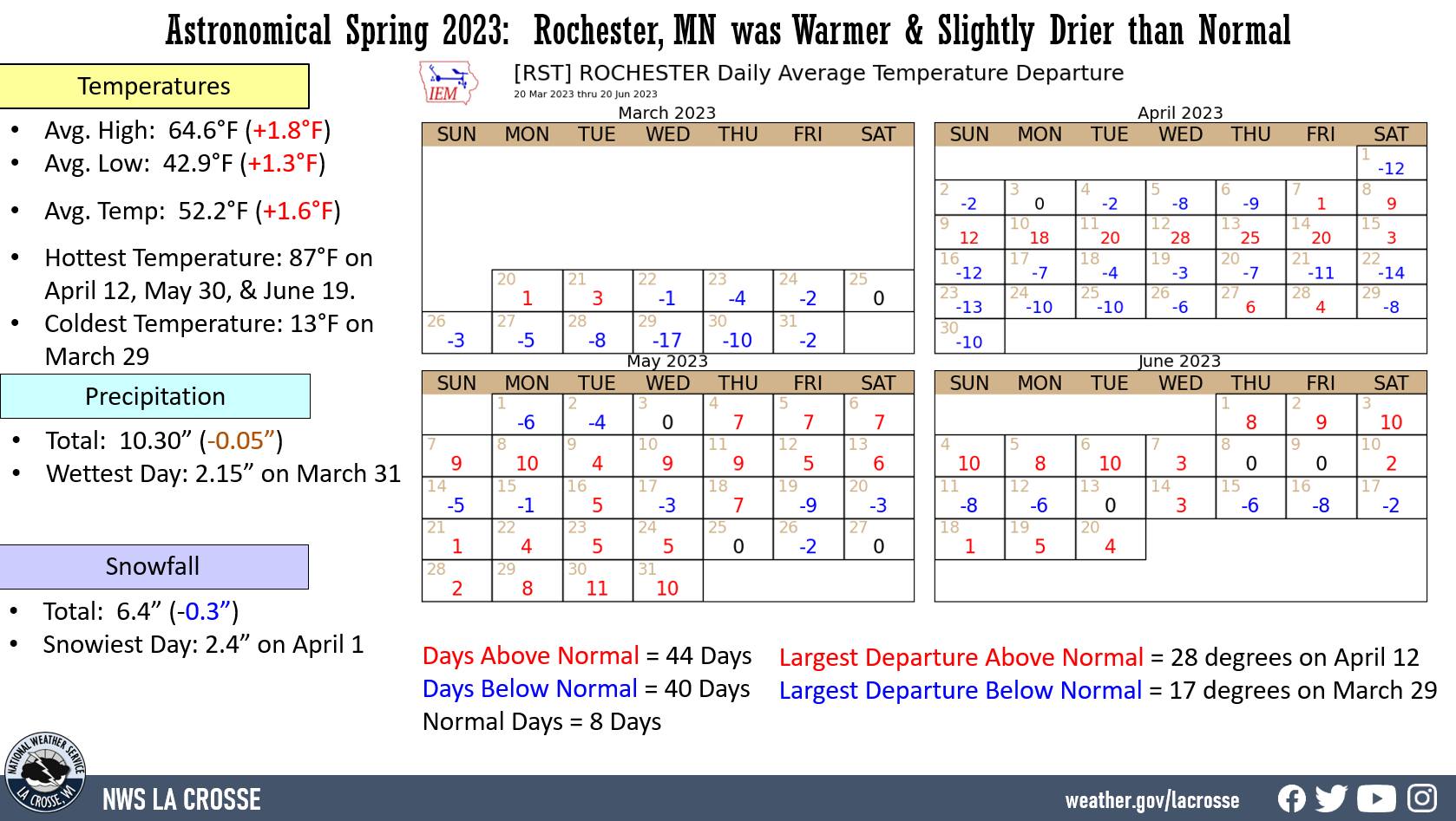 |
The warmest high temperature was 87°F on April 12, May 30, and June 19.
The coldest high temperature was 29°F on March 297.
The warmest low temperature was 65°F on June 6.
The coldest low temperature was 13°F on March 29.
There were 0 days in which the high temperature reached or exceeded 90°F. The long-term average is 2 days.
There were 26 days in which the low temperature was 32°F or colder. The long-term average is 24 days.
Precipitation - Slightly Drier than Average
From March 20 through June 20, Rochester International Airport received 10.30" of precipitation. This was 0.05" drier than the long-term average of 10.35". 2 out of 3 last springs have been drier than average. Prior to this, there were 8 consecutive wet springs (2013-2020). Through May 15, 9.79" of precipitation fell. This was 94.6% of the seasonal precipitation. Since then 0.51" of rain has fallen (5.4% of the seasonal total).
Measurable precipitation (0.01" or greater) fell on 28 days (30.1%) and a trace of precipitation fell on 9 days (9.7%).
Number of days with...
None 56 days (60.2%)
Trace 9 days ( 9.7%)
0.01-0.09 inches 11 days (11.8%)
0.10-0.24 inches 4 days ( 4.3%)
0.25-0.49 inches 7 days ( 7.5%)
0.50-0.99 inches 3 days ( 3.2%)
1.00-1.99 inches 2 days ( 2.2%)
2.00-2.99 inches 1 day ( 1.1%)
The wettest spring day was 2.15" on March 31.
Snowfall - Slightly Below Average
From March 20 through June 20, the snow observer near Rochester International Airport measured 6.4" of snow. This was 0.3" below the long-term average of 6.7".
Measurable snow (0.1" or greater) fell on 3 days (3.2%) and a trace of precipitation fell on 8 days (8.6%).
Number of days with...
No snow 82 Days (88.2%)
Trace 8 Days ( 8.6%)
0.1-0.9 inches 0 Days ( 0.0%)
1.0-2.9 inches 3 Days ( 3.2%)
The snowiest day was 2.4" on April 1.
Snow Depth - Less than Average
From March 20 through June 20, the average snow depth near Rochester International Airport was 0.1". This was 0.2" below the long-term average of 0.3".
Number of days with...
No snow 90 Days (96.8%)
Trace 0 Days ( 0.0%)
1-3 inches 2 Days ( 2.2%)
4-6 inches 1 Day ( 1.1%)
The greatest snow depth was 5" on April 1.


 Weather Story
 Weather Map
 Local Radar