During the astronomical summer of 2021 (June 20-September 20), average temperatures ranged from 2 degrees colder-than-normal to 2 degrees warmer-than-normal. Average temperatures ranged from 63.2°F at Medford Taylor County Airport to 73.1°F at La Crosse Regional Airport. The highest temperature was 96°F at Theilman, MN and the coldest temperature was 32°F on September 18 at Black River Falls, WI.
Rainfall was highly variable across the region. Rainfall totals ranged from 9.64" near Claremont, MN to 25.93" near Harpers Ferry, IA. Typically rainfall ranges from 12" to 15". It was the wettest summer at La Crosse, WI (21.93"). The previous record was 21.73" in 2016. It was the second wettest astronomical season. Only the spring of 1993 was wetter with 23.08".
The summer began with severe drought (D2) across parts of southeast Minnesota, northeast Iowa, and southwest Wisconsin. During July, above-normal rainfall gradually ended the abnormally dry (D0) and moderate drought (D1) across west-central, central, and north-central Wisconsin. In early August, extreme drought (D3) develop across northeast Iowa. This was the first time that this had been seen in the area since 2012. Above-normal rain in late August helped to end the drought across southeast Minnesota, and much of northeast Iowa and southwest Wisconsin.
 |
 |
| Average Temperature Anomalies | Precipitation Anomalies |
Below are the summaries for both La Crosse, WI, and Rochester, MN.
During the astronomical summer of 2021 (June 20 through September 21), it was the wettest summer (21.93" - the previous record was 21.73" in 2016) and tied with 2002 and 2016 for the 14th warmest summer at La Crosse Regional Airport. Records date back to 1873.
More details are listed below...
Temperatures - Tied for 14th Warmest with 2002 and 2016
| During astronomical summer, La Crosse Regional Airport had an average temperature of 73.1°F. This was 2.8°F warmer than the long-term average of 70.3°F. This was tied for the 14th warmest summer with 2002 and 2016. It was the warmest since 2019 (73.4°F - tied for 9th warmest with 1995 and 2005). Since 1995, 24 out 27 astronomical summers have been warmer than normal. This includes the 4th warmest (tied 1998 and 2018), 9th warmest (tied 2005 and 2019), 14th warmest (tied 2002, 2016, and 2021), and 18th warmest (2012). |  |
The average maximum temperature was 83.5°F. This was 3.0°F warmer than the long-term average of 80.5°F. The was tied for 18th warmest with 1930.
The average minimum temperature was 62.7°F. This was 2.7°F warmer than the long-term average of 60°F. This was tied for 11th warmest with 1948, 1955, and 1995.
Other temperature tidbits this summer...
The temperature climbed to or exceeded 90°F on 18 days. Normally, there are 13 days in the summer.
Rainfall - Wettest
During the astronomical summer, La Crosse Regional Airport received 21.93" of rain which was 9.88" wetter than the long-term normal of 12.05". The table below lists the ten wettest astronomical summers in La Crosse WI...
Ten Wettest Astronomical Summers
in La Crosse WI
1873-2021
Rank Rainfall Year
---- -------- ----
1 21.93 inches 2021
2 21.73 inches 2016
3 21.57 inches 1938
4 21.42 inches 1928
5 20.87 inches 1881
6 20.20 inches 1980
7 19.73 inches 2007
8 19.56 inches 2010
9 19.11 inches 1981
10 18.28 inches 1884
Other precipitation tidbits this summer...
Here is a breakdown of the summer rain...
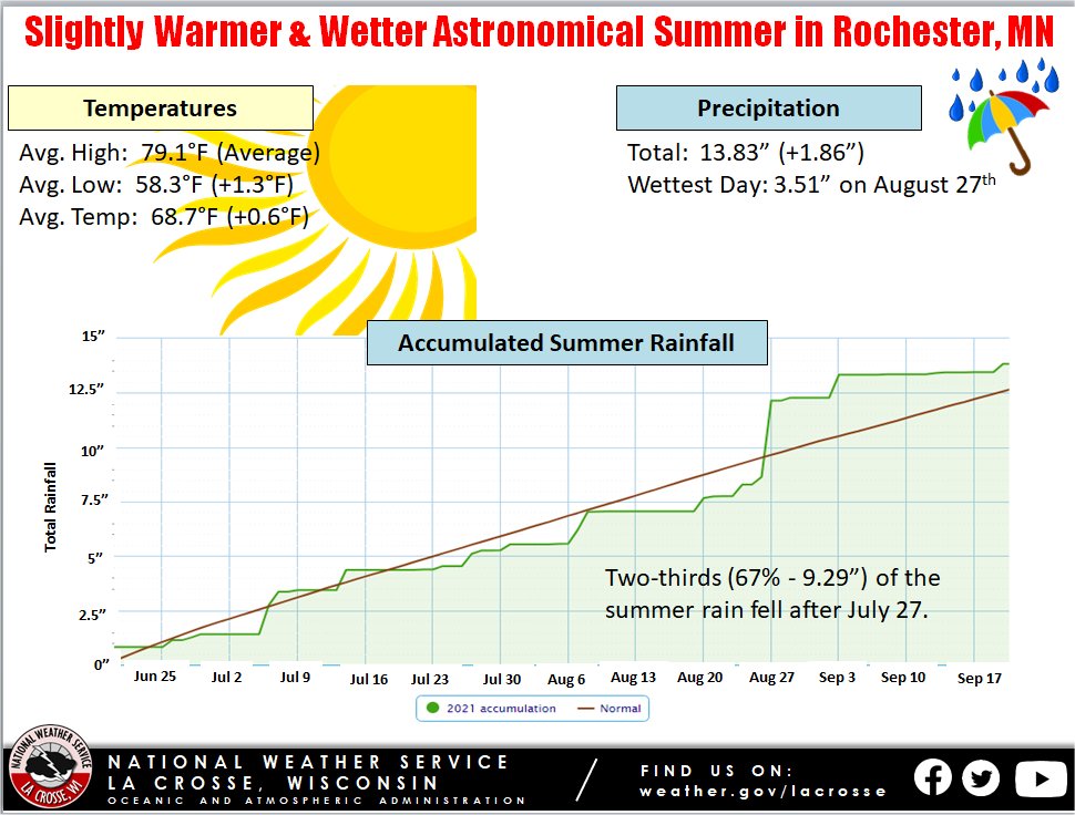
During the astronomical summer of 2021 (June 20 through September 21), it was slightly warmer and wetter than the long-term average at Rochester International Airport.
More details are listed below...
Temperatures - Slightly Warmer than the Long-Term Average
|
During astronomical summer, Rochester International Airport had an average temperature of 68.7 degrees. This was 0.6°F warmer than the long-term average of 68.1°F. The average maximum temperature was 79.1°F. This tied the long-term average of 79.1°F. The average minimum temperature was 58.3°F. This was 1.3°F warmer than the long-term average of 57.1°F. |
 |
Other temperature tidbits this summer...
The temperature climbed to or exceeded 90°F on 2 days. Normally, there are 9 days per summer.
Rainfall - Slightly Wetter than the Long-Term Average
During the astronomical summer, Rochester International Airport received 13.83" of rain which was 1.86" wetter than the long-term normal of 11.97". 6 out of the last 8 summers have been wetter than the long-term normal.
Other precipitation tidbits this summer...
Here is a breakdown of the summer rain...


 Weather Story
 Weather Map
 Local Radar