Upper Mississippi River Valley
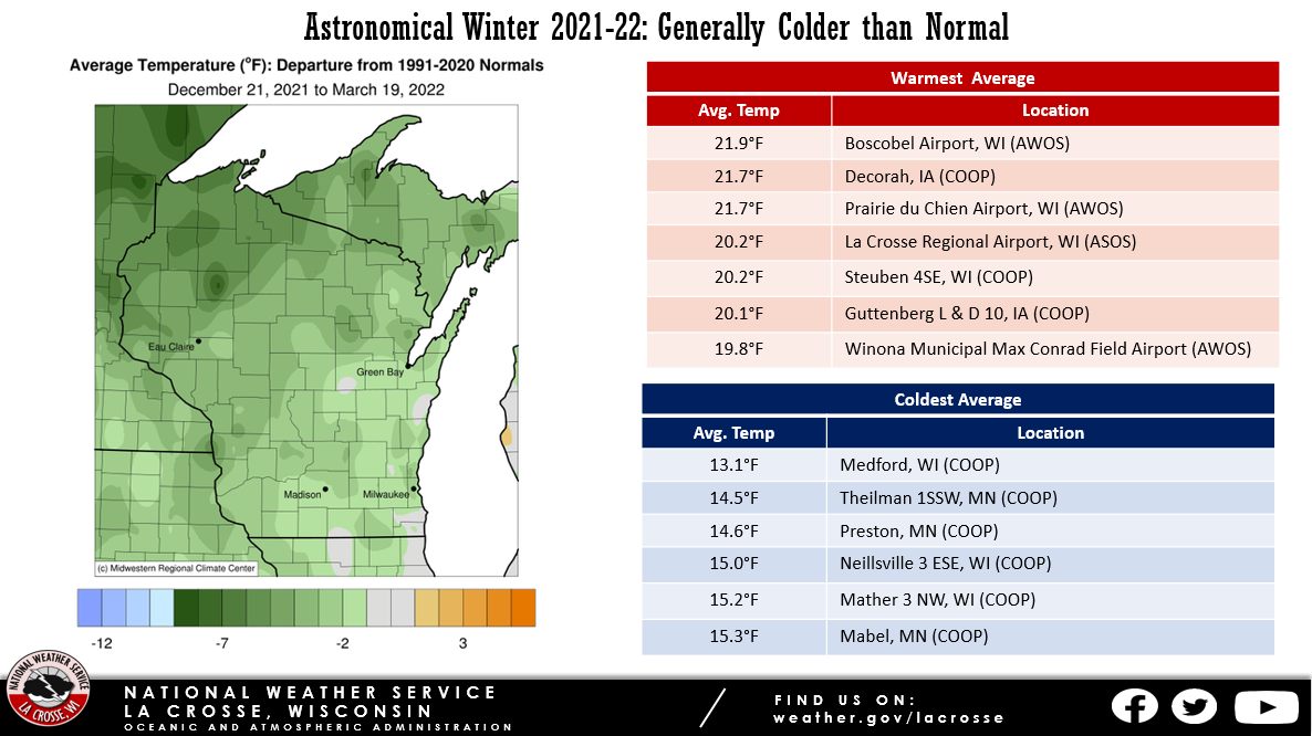
Temperatures - Generally Below Normal
| During the astronomical winter of 2021-22 (December 21-March 19), average temperatures ranged from 13.1°F at Medford, WI (COOP observer) to 21.9°F Boscobel, WI (ASOS) in the Upper Mississippi River Valley. These temperatures were anywhere from near normal to 5°F colder than normal. The warmest temperature was 70°F at the Boscobel and La Crosse airports on March 16. Meanwhile, the coldest temperature was -36°F on January 26. This is a 106°F difference. |
 |
Precipitation - Drier than Average
| Precipitation totals ranged from 1.16" near Osage, IA to 5.94" near Elkader, IA. This precipitation ranged from near normal to 3" below normal. The highest one-day precipitation was 1.92" near Elkader from March 5-6. |
 |
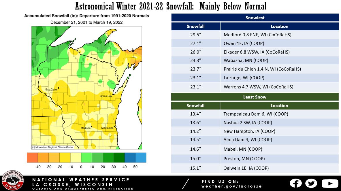
Snowfall - Below Average
| Seasonal snowfall totals ranged from 13.4" at Trempealeau Dam 6 to 29.5" near Medford, WI. This snowfall ranged from near normal to 10" below normal. The highest one-day snowfall was 8" near Nora Springs, IA from January 14-15. |
 |
During the 2021-22 astronomical winter (December 21-March 19), both La Crosse, WI, and Rochester, MN saw near-normal temperatures and below-normal precipitation. Below are more details on each of these sites...
La Crosse WI...
Temperatures - Near Average
- During astronomical winter, temperatures averaged 20.2°F at La Crosse Regional Airport. This was 0.7°F colder than the long-term (1872-2022) average of 20.9°F.
- Coldest astronomical winter since 2018-2019 (19.2°F).
- The average high temperature was 30.4°F. This was 0.7°F warmer than the long-term average of 29.7°F.
- The average low temperature was 10°F. This was 2.1°F colder than the long-term average of 12.1°F.
|
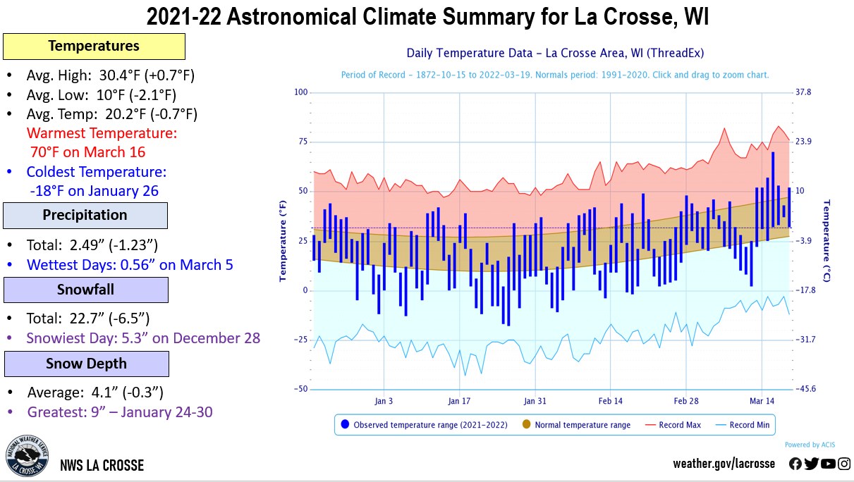 |
- The warmest high temperature was 70°F on March 16.
- The coldest high temperature was 2°F on January 25.
- The warmest low temperature was 37°F on March 18.
- The coldest low temperature was -18°F on January 26.
Precipitation - Drier than Average
- During astronomical winter, a total of 2.49" of precipitation fell at La Crosse Regional Airport. This was 1.23 inches drier than the long-term (1872-2022) average of 3.72".
- Driest astronomical winter since 2014-2015 (1.83" - 12th driest).
- The wettest day occurred on March 5 when 0.56" of precipitation fell.
- Measurable (0.01" or greater) precipitation fell on 22 days (24.7%) and trace amounts of precipitation fell on another 15 days (16.9%).
Snowfall - Below Average
- During astronomical winter, a total of 22.7" of snow was measured by the official NWS snow observer near La Crosse Regional Airport. This was 6.5" below the long-term (1896-2022) average of 29.2".
- Least snow in an astronomical winter since 2014-2015 (20.5").
- The snowiest day occurred on December 28 when 5.3" of snow fell.
- Measurable (0.1" or greater) snow fell on 18 days (20.2%) and trace amounts of snow fell on another 16 days (18%).
Snow Depth - Slightly Below Average
- During astronomical winter, the average snow depth measured by the official NWS snow observer was 4.1". This was 0.3" inches below the long-term (1893-2022) average of 4.4".
- Lowest average snow depth in an astronomical winter since 2019-2020 (3.7").
- Measurable snow was on the ground on 69 days or 77.5% of the season.
- There was no snow on the ground for 20 days or 22.5% of the season.
- The greatest snow depth was 9" from January 24 through January 30.
Rochester...
Temperatures - Slightly Colder than Average
- During astronomical winter, temperatures averaged 16.6°F at Rochester International Airport. This was 1.2°F colder than the long-term (1886-2022) average of 17.8°F.
- Coldest astronomical winter since 2018-2019 (14.8°F).
- The average high temperature was 26°F. This was 0.5°F colder than the long-term average of 26.5°F.
- The average low temperature was 7.1°F. This was 1.9°F colder than the long-term average of 9°F.
|
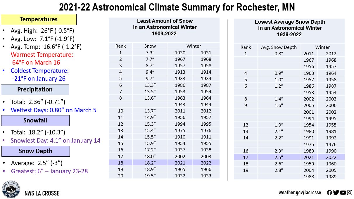 |
- The warmest high temperature was 64°F on March 16.
- The coldest high temperature was -2°F on January 25.
- The warmest low temperature was 37°F on March 16.
- The coldest low temperature was -21°F on January 26.
Precipitation - Slightly Below Average
- During astronomical winter, a total of 2.36" of precipitation fell at Rochester International Airport. This was 0.71" drier than the long-term (1886-2022) average of 3.07". This was the driest astronomical winter since 2014-2015 (2.20").
- The wettest day occurred on March 5 when 0.80" of precipitation fell.
- Measurable (0.01" or greater) precipitation fell on 21 days (23.6%) and trace amounts of precipitation fell on another 20 days (22.5%).
Snowfall - 18th Least
- During astronomical winter, a total of 18.2" of snow was measured by the official NWS snow observer near Rochester International Airport. This was 10.3" below the long-term (1909-2022) average of 28.5". This was the least amount of snow in an astronomical winter since 2011-12 (13.7" - 10th least) and the 18th least for an astronomical winter. In contrast, the greatest total in an astronomical winter was 65.1" in 2018-19. Below are the 20 astronomical winters with the least amount of snow.
Least Amount of Snow
in an Astronomical Winter
1909-2022
Rank Snowfall Winter
---- -------- ------
1 7.3 inches 1930-1931
2 7.7 inches 1967-1968
3 8.7 inches 1957-1958
4 9.4 inches 1913-1914
5 9.7 inches 1933-1934
6 13.3 inches 1986-1987
7 13.5 inches 1953-1954
8 13.6 inches 1963-1964
13.6 inches 1943-1944
10 13.7 inches 2011-2012
11 14.9 inches 1956-1957
12 15.3 inches 1994-1995
13 15.4 inches 1975-1976
14 15.5 inches 1910-1911
15 15.9 inches 1954-1955
16 17.2 inches 1937-1938
17 18.0 inches 2002-2003
18 18.2 inches 2021-2022
19 18.9 inches 1965-1966
20 19.5 inches 1932-1933
- The snowiest day occurred on January 14 when 4.1" of snow fell.
- Measurable (0.1" or greater) snow fell on 18 days (20.2%) and trace amounts of snow fell on another 16 days (18%).
Snow Depth - 17th Least
- During astronomical winter, the average snow depth measured by the official NWS snow observer near Rochester International Airport was 2.5". This was 3" lower than the long-term (1938-2022) average of 5.6".
- This was the lowest seasonal average snow depth in an astronomical winter since 2011-12 (0.8" - tied for the least with 1956-57, 1967-68, and 2011-12) and the 17th least for an astronomical winter. In contrast, the greatest average snow depth in an astronomical winter was 15.6" in 1978-79. Below are the 20 astronomical winters with the least amount of snow.
Lowest Average Snow Depth
in an Astronomical Winter
1938-2022
Average
Rank Snow Depth Winter
---- ---------- ------
1 0.8 inches 2011-2012
0.8 inches 1967-1968
0.8 inches 1956-1957
4 0.9 inches 1963-1964
5 1.0 inches 1957-1958
6 1.2 inches 1986-1987
1.2 inches 1953-1954
8 1.4 inches 2002-2003
9 1.6 inches 2005-2006
1.6 inches 2001-2002
1.6 inches 1994-1995
12 1.9 inches 1954-1955
13 2.1 inches 1980-1981
14 2.2 inches 1991-1992
2.2 inches 1975-1976
16 2.3 inches 1989-1990
17 2.5 inches 2021-2022
18 2.6 inches 1959-1960
19 2.8 inches 2004-2005
2.8 inches 1988-1989
- Measurable snow was on the ground for 60 days or 67.4% of the season.
- A trace of snow was on the ground on 5 days or 5.6% of the season.
- There was no snow on the ground on 24 days or 27% of the season.
- The greatest snow depth was 6" from January 23 through January 28.


 Weather Story
 Weather Map
 Local Radar