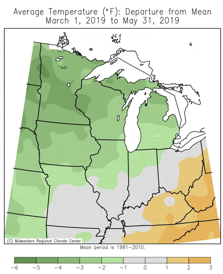
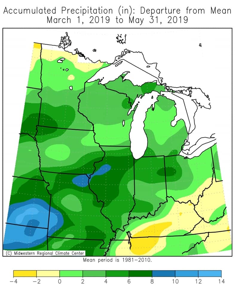
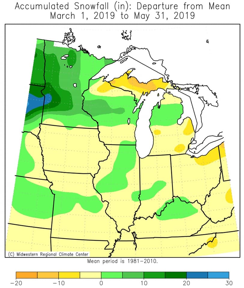
Meteorological Spring (March 1 to May 31) was colder and wetter-than-normal across the Upper Mississippi River Valley. Average temperatures ranged from 37.1°F (Medford, WI) to 46.3°F (Guttenberg Lock & Dam 10). These temperatures were 2 to 4°F below normal. Precipitation totals ranged from 8.29 inches (3 NW of Mather, WI) to 14.89 inches (Rochester International Airport). These values ranged from near-normal to around 6 inches wetter-than-normal. Spring snowfall ranged from a half inch (Guttenberg Lock & Dam 10) to 16.4" (Alma Dam 4). These values ranged from near-normal to 10" above normal.
More specifics can be found for La Crosse, WI and Rochester, MN.
 |
 |
 |
| Spring Temperature Departures from the 1981-2010 Normal |
Spring Precipitation Departures from the 1981-2010 Normal |
Spring Snowfall Departures from the 1981-2010 Normal |
...Another Wet Spring in La Crosse WI...
The meteorological spring of 2019 was another wet one at La Crosse Regional Airport. It was the 24th wettest meteorological spring. This was the 6th time this decade and the 9th time this century that a spring has been among the 25 wettest springs. Temperatures averaged just over 2 degrees (-2.1F) colder-than-normal.
More details on these statistics can be found below.
Temperatures -
From March 1st through May 31st, La Crosse Regional Airport had an average temperature of 45.5F. This was 2.1F colder than the 1981-2010 normal of 47.6F. It was the coldest spring since 2014 when the average temperature was 44.3F.
The table below contains the monthly temperatures and their departures from normal for the spring of 2019.
Spring 2019 Temperatures
in La Crosse WI
Average Departure
Month Temperature from Normal
----- ----------- -----------
March 30.2 degrees -4.3 degrees
April 48.5 degrees -0.1 degrees
May 57.7 degrees -2.0 degrees
Spring 45.5 degrees -2.1 degrees
Precipitation - 24th wettest
From March 1st through May 31st, La Crosse Regional Airport received 11.01 inches of precipitation. This was 2.11 inches wetter than the 1981-2010 spring normal of 8.90 inches. This made it the 24th wettest meteorological spring. This was the 6th time this decade and the 9th time this century that a spring has been among the 25 wettest springs.
Below are the 25 wettest springs in La Crosse WI.
Wettest Springs
in La Crosse WI
1873-2019
Precipitation
Rank Total Year
---- ------------ ----
1 17.21 inches 1973
2 16.53 inches 2013
3 15.37 inches 1945
4 15.04 inches 1991
5 14.61 inches 2004
6 13.83 inches 2017
7 13.70 inches 1993
8 13.61 inches 1888
9 13.28 inches 1908
10 13.11 inches 1903
11 12.88 inches 1960
12 12.41 inches 2008
13 12.31 inches 1951
14 12.29 inches 1892
15 12.03 inches 1965
16 11.97 inches 1876
17 11.53 inches 2018
18 11.51 inches 2006
19 11.41 inches 1956
20 11.38 inches 2015
21 11.17 inches 2011
22 11.10 inches 1913
23 11.07 inches 1938
24 11.01 inches 2019
25 10.99 inches 1999
10.99 inches 1918
The table below contains the monthly precipitation totals and their departures from normal for the spring of 2019.
Spring 2019 Precipitation
in La Crosse WI
Precipitation Departure
Month Total from Normal
----- ------------ -----------
March 1.81 inches -0.23 inches
April 3.17 inches -0.17 inches
May 6.03 inches +2.51 inches - 17th Wettest
Spring 11.01 inches +2.11 inches - 24th Wettest
Snowfall -
From March 1st through May 31st, the snow observer near La Crosse Regional Airport recorded 12.1 inches. This was 3.3 inches snowier than the 1981-2010 normal of 8.8 inches. The table below contains the monthly snowfall totals and their departures from normal for the spring of 2019.
Spring 2019 Snowfall
in La Crosse WI
Snowfall Departure
Month Total from Normal
----- ------------ -----------
March 5.9 inches -1.2 inches
April 6.2 inches +4.5 inches
May 0 inches 0.0 inches
Spring 12.1 inches +3.3 inches
...Another Cold and Wet Meteorological Spring at Rochester MN...
During the meteorological spring of 2019, it was cold (4.2F colder than the 1981-2010 normal) and wet (4th wettest and 6th time this decade to be among the 25 wettest springs) at Rochester International Airport. More details on these statistics can be found below.
Temperatures -
From March 1st through May 31st, Rochester International Airport had an average temperature of 41.5 degrees. This was 4.2 degrees colder than the 1981-2010 normal of 45.7 degrees.
The table below contains the monthly temperatures and their departures from normal for the spring of 2019.
Spring 2019 Temperatures
in Rochester MN
Average Departure
Month Temperature from Normal
----- ----------- -----------
March 25.9 degrees -6.5 degrees
April 44.8 degrees -1.9 degrees
May 53.9 degrees -4.2 degrees
Spring 41.5 degrees -4.2 degrees
Precipitation - 4th Wettest
From March 1st through May 31st, Rochester International Airport received 14.82 inches of precipitation. This was 6.07 inches wetter than the 1981-2010 normal of 8.75 inches. This was the 4th wettest spring. This is the 6th time this decade (2011, 2013, 2015, 2016, 2017, and 2019) and the 8th time this century that a spring has been among the 25 wettest springs. Below are the 10 wettest springs in Rochester MN.
Wettest Springs
in Rochester MN
1886-2019
Precipitation
Rank Total Year
---- ------------ ----
1 21.90 inches 2013
2 15.87 inches 2001
3 15.09 inches 1888
4 14.82 inches 2019
5 14.57 inches 1990
6 14.35 inches 1945
7 12.85 inches 1982
8 12.60 inches 1999
9 12.37 inches 1973
10 12.06 inches 1938
The table below contains the monthly precipitation totals and their departures from normal for the spring of 2019.
Spring 2019 Precipitation
in Rochester MN
Precipitation Departure
Month Total from Normal
----- ------------ -----------
March 1.47 inches -0.41 inches
April 3.93 inches +0.69 inches
May 9.42 inches +5.79 inches - 2nd Wettest
Spring 14.82 inches +6.07 inches - 4th Wettest
Snowfall -
From March 1st through May 31st, the snow observer near Rochester International Airport recorded 13.0 inches of snow. This was 1 inch snowier than the 1981-2010 normal of 12.0 inches. The table below contains the monthly snowfall totals and their departures from normal for the spring of 2019.
Spring 2019 Snowfall
in Rochester MN
Snowfall Departure
Month Total from Normal
----- ------------ -----------
March 4.8 inches -3.9 inches
April 8.2 inches +4.9 inches
May 0.0 inches 0.0 inches
Spring 13.0 inches +1.0 inch

