Heavy, wet snow and potential icing continues across northern Michigan today into tonight. Read More >
Overview
Thunderstorms developed across portions of west central Michigan during the morning hours of Saturday, July 20th, 2019. These thunderstorms continues to regenerate along a stationary boundary in an abnormally hot and humid air mass.
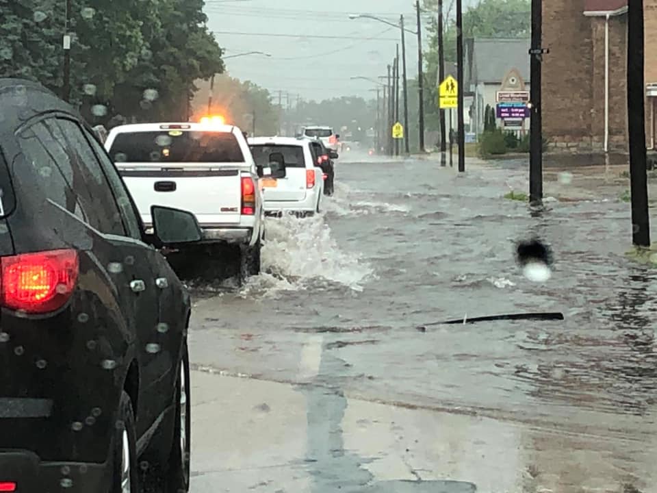
However, a line of thunderstorms raced across Wisconsin during the late morning hours, arriving across parts of northern and central lower Michigan during the early-mid afternoon with damaging wind gusts and more torrential downpours. When all was said and done, sporadic wind damage with occasional road closures was reported across portions of northwest lower Michigan along with 4-8"+ (locally up to 12") of rain in parts of Manistee, Mason and Lake counties.
Heavy Rain/Flooding:
Heavy rain accompanied the thunderstorms with the hardest hit areas across portions of Manistee, Mason and Lake counties
in northwest lower Michigan.
 |
| KAPX Doppler Radar Estimated Rainfall Amounts July 20th, 2019 |
 |
 |
 |
 |
| River Street - Manistee, MI Steve Mitchell |
US 31 - North of Scottville Steve Mitchell |
Orchard Beach St Park - Manistee Bryan Miller |
US 31 - Manistee, MI Edward Bradford |
 |
.20flooding5%20Reed%20City%20-%20Michael%20ODea.jpg) |
 |
 |
| River Street - Manistee, MI James Beaudrie |
Reed City, MI Michael O'Dea |
Lake Michigan Road - NW of Honor Anne Clark |
12th St. Runoff - Manistee, MI Michael Palko |
Storm Reports
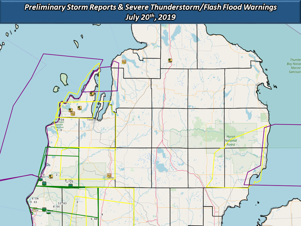
The following is a preliminary storm reports map from July 20th, 2019. Damage to trees and power lines were reported, primarily across the Grand Traverse Bay region of northwest lower Michigan, including significant reports of flooding. Also included on this map are severe thunderstorm warnings in yellow, marine warnings in purple, and flash flood warnings in green.

..TIME...   ...EVENT...      ...CITY LOCATION...     ...LAT.LON...
..DATE...   ....MAG....      ..COUNTY LOCATION..ST.. ...SOURCE....
            ..REMARKS..

0202 PM     TSTM WND GST     3 SSW MAPLE CITY        44.81N 85.90W
07/20/2019  M48 MPH          LEELANAU           MI   MESONET


0315 PM     TSTM WND GST     1 N CADILLAC            44.27N 85.42W
07/20/2019  M40 MPH          WEXFORD            MI   AWOS

            AWOS STATION KCAD CADILLAC - WEXFORD COUNT
            ARPT.

0320 PM     TSTM WND GST     1 WSW IRONTON           45.26N 85.22W
07/20/2019  M39 MPH          CHARLEVOIX         MI   MESONET

            MESONET STATION DW7501 CHARLEVOIX.

0500 PM     HEAVY RAIN       1 NW PARKDALE           44.28N 86.31W
07/20/2019  E8.90 INCH       MANISTEE           MI   PUBLIC

            STORM TOTAL RAIN AS OF 5:00PM.

0347 PM     HEAVY RAIN       1 N MANISTEE            44.26N 86.32W
07/20/2019  M6.57 INCH       MANISTEE           MI   MESONET

            MESONET STATION DW3748 MANISTEE.

0355 PM     HEAVY RAIN       1 NNW WELLSTON          44.23N 85.96W
07/20/2019  M5.35 INCH       MANISTEE           MI   MESONET

            MESONET STATION EW0269 WELLSTON.

0346 PM     HEAVY RAIN       1 SSW MANISTEE          44.23N 86.34W
07/20/2019  M3.91 INCH       MANISTEE           MI   MESONET

            MESONET STATION DW9113 MANISTEE.

0308 PM     HEAVY RAIN       4 S EMPIRE              44.76N 86.06W
07/20/2019  M3.56 INCH       BENZIE             MI   MESONET

            MESONET STATION SBDM4 BEAR.

0235 PM     TSTM WND DMG     1 SE BURDICKVILLE       44.84N 85.93W
07/20/2019                   LEELANAU           MI   LAW ENFORCEMENT

            TREES DOWN ON ROAD.

0235 PM     TSTM WND DMG     1 NW CEDAR              44.86N 85.81W
07/20/2019                   LEELANAU           MI   LAW ENFORCEMENT

            TREES ACROSS ROAD.

0252 PM     TSTM WND DMG     1 NE SUTTONS BAY        44.99N 85.64W
07/20/2019                   LEELANAU           MI   LAW ENFORCEMENT

            TREE DOWN BLOCKING M-22 NORTH OF SUTTONS
            BAY.

0257 PM     TSTM WND DMG     SUTTONS BAY             44.98N 85.65W
07/20/2019                   LEELANAU           MI   LAW ENFORCEMENT

            TREES REPORTED DOWN VIA LAW ENFORCEMENT.

0150 PM     FLASH FLOOD      DUBLIN                  44.18N 85.93W
07/20/2019                   MANISTEE           MI   PUBLIC

            STORE TAKING ON WATER NORTH OF IRONS.

0300 PM     FLASH FLOOD      1 S MANISTEE            44.24N 86.33W
07/20/2019                   MANISTEE           MI   PUBLIC

            FLOODING SURROUNDING SOME 12TH STREET
            RESIDENCES.

0300 PM     FLOOD            3 S EASTLAKE            44.20N 86.28W
07/20/2019                   MANISTEE           MI   LAW ENFORCEMENT

            WATER OVER ROAD DUE TO HEAVY RAIN.

0317 PM     TSTM WND DMG     5 ENE EASTLAKE          44.26N 86.19W
07/20/2019                   MANISTEE           MI   LAW ENFORCEMENT

            TREES DOWN.

0330 PM     TSTM WND DMG     1 SW WOLVERINE          45.27N 84.61W
07/20/2019                   CHEBOYGAN          MI   TRAINED SPOTTER

            MULTIPLE TREES DOWN.
 |
Media use of NWS Web News Stories is encouraged! Please acknowledge the NWS as the source of any news information accessed from this site. |
 |