Bruce B. Smith, and John P. Boris, NWS Gaylord
1. Background
Starting the winter of 2008-2009 the National Weather Service in Gaylord will begin using a new tool to assist with lake effect snow forecasting. This tool, referred to as the Lake Snow Parameter (LSP), is designed to help forecasters more accurately anticipate the location, timing, and intensity of lake snows around the Great Lakes. The LSP is a quantitative measure of the likelihood of high snowfall rates, and is based on data collected during a four year research project conducted by the National Weather Service in Gaylord.
2. Motivation for Developing the Lake Snow Parameter
Forecasting lake effect snow is extremely challenging. There are many reasons for this, among them is the fact that 1) snow accumulations are often very localized, and 2) many complex factors must be considered when forecasting lake effect snow. Several of the factors that must be accurately assessed include: air temperature, water temperature, air-water temperature difference (or Delta-T), instability, instability depth (or inversion height), snow microphysics, upstream moisture, large-scale lift, wind direction, wind speed, fetch length, inland elevation changes, and shoreline orientation.
Assessing the relative importance of these factors on lake snow production is often very difficult, especially when the various factors change in space and time. For example, large-scale lift and moisture may be ideal for lake snow today, while the best snow microphysics may not arrive until tonight. This may result in only a brief three to six hour window when both of these favorable conditions overlap. This forecast challenge (very typical during lake snow events) was the basic motivation for developing the Lake Snow Parameter. In other words, the goal was to develop an operational parameter that accounted for multiple meteorological factors simultaneously and increased when the probability of higher snowfall rates increased.
3. Calculation of the Lake Snow Parameter
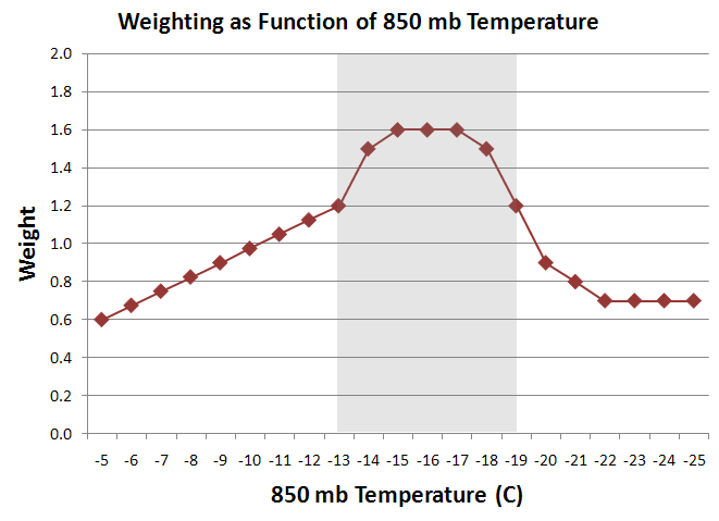
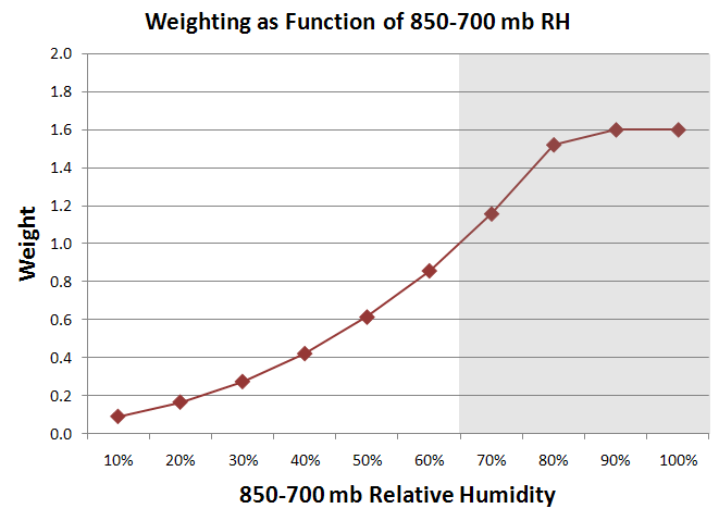
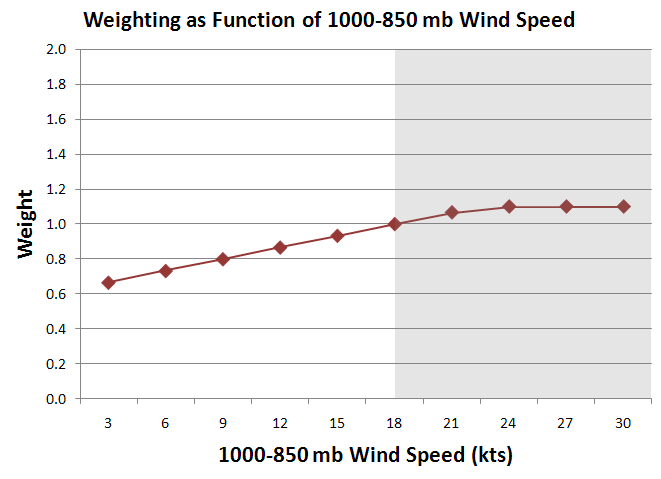
A four year research project conducted by the National Weather Service in Gaylord isolated three factors very critical for lake snow production in northern Michigan. Though all of the meteorological factors listed above are important (and must be considered) the three factors found to be particularly critical included 1) 850 mb temperature, 2) 850-700 mb mean relative humidity, and 3) 1000-850 mb wind speed.
Based on local research, 850 mb temperatures between roughly -12°C and -19°C tended to promote heavier snowfall. This is not surprising, since 850 mb is located near the middle of the snow production layer for many lake snow events, and this temperature range (coupled with sufficient moisture and lift) helps to promote the development of large dendrites (snowflakes). High relative humidity in the 850-700 mb layer was also well correlated with heavy lake snow. There are two reasons for this: 1) It can indicate a higher inversion and therefore a greater convective depth for snow production (pure lake effect), or 2) It can indicate synoptic moisture above the inversion, with implied synoptic ascent and/or seeding from clouds above (lake enhancement). As boundary layer wind speed increased, local research indicated a tendency for greater snowfall. This is consistent with the known relationships between higher wind speeds and greater heat and moisture flux across an air-water interface. As a result, 1000-850 mb wind speed is the third factor considered in the LSP (of the three factors included, wind speed has the least overall impact on the LSP).
The LSP is non-dimensional, and is the product of three Weighting Functions (WF) -- one WF for each of the meteorological parameters previously described.
Lake Snow Parameter (LSP) =
WF(850 mb Temp) x WF(850-700 mb RH) x WF (1000-850 mb WS (Wind Speed))
The weighting function for each of the meteorological parameters is shown below (click to enlarge).
|
|
|
|
Two example LSP calculations follow. Example One: 850 mb Temperature = -16°C (excellent for large dendrites), 850-700 mb RH = 75% (high), and 1000-850 mb Wind Speed = 19 kts (moderate) would result in a Lake Snow Parameter of 2.17 (1.60 x 1.33 x 1.02). Example Two: 850 mb Temperature = -24°C (too cold for large dendrites), 850-700 mb RH = 50% (moderate), and 1000-850 mb Wind Speed = 17 kts (moderate) would result in a Lake Snow Parameter of 0.42 (0.70 x 0.61 x 0.98).
4. Operational Use and Limitations of the Lake Snow Parameter
The Lake Snow Parameter is a tool. It cannot replace a thorough examination of all meteorological factors contributing to the lake snow event!
Forecasters should not use the LSP to determine if lake snow will occur. Rather, they should look at spatial and temporal trends in the LSP, as well as the magnitude of the LSP, to help them more accurately anticipate the timing and location of higher snowfall rates associated with lake snow events. It is hoped that by using the LSP in this manner (as a situational awareness tool) forecasters will more quickly recognize when subtle meteorological changes may impact the behavior and magnitude of a lake snow event.
Preliminary experience suggests the following Lake Snow Parameter thresholds for anticipating the likelihood of high snowfall rates:
| LSP Range | Potential for High Snowfall Rates |
| Less than 1.0 | Low Potential |
| From 1.0 to 2.0 | Moderate Potential (conditional) |
| Greater than 2.0 | High Potential |
Lastly, it should be noted that since the LSP was developed over northern Lower Michigan (where multiple band lake snow events are most common) its direct application to other parts of the Great Lakes may be problematic. For example, because single band lake effect snow events have different characteristics than multiple band events, the LSP may have limitations in some areas. In addition, the LSP does not directly account for the impact of forced topographic ascent, fetch length, vertical wind shear, or kinematic vertical motion.
Forecasters may find the LSP particularly useful when viewed together with low level model omega fields. The resulting diagnostics would not be unlike the "cross hair" signature for heavy synoptic snow.