
By Bruce B. Smith, Meteorologist, NWS Gaylord
What is Lake Effect Snow?
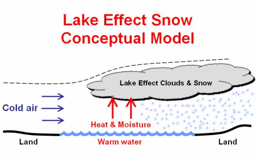
Lake Effect Snow (LES) is very common across the Great Lakes region during the late fall and winter. LES occurs when cold air, often originating from Canada, moves across the open waters of the Great Lakes. As the cold air passes over the unfrozen, and relatively warm waters of the Great Lakes, warmth and moisture is transferred into the lowest portion of the atmosphere. The air becomes warmer and less dense than the overriding cold air, so it rises. The rising air ultimately leads to cloudiness and snow on the leeward sides of the Great Lakes. A conceptual model has been developed highlighting these concepts.
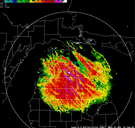
LES typically takes the form of discrete, narrow bands. These bands are often characterized by intense snowfall, and limited visibility. One unique aspect of LES is the extreme variability that can occur in space and time. It is not uncommon for sunny skies at a particular location to be quickly replaced by blinding, wind-driven snowfall in a matter of minutes. Similarly, snowfall accumulations can vary from a trace to several inches over a short distance. The variability of LES is of particular danger to motorists.
How does the National Weather Service forecast LES?
National Weather Service (NWS) meteorologists must consider many factors when forecasting the intensity and location of LES. Many are associated with the prevailing meteorological situation, while others are a function of the local geography.
A few of the meteorological factors that impact LES include air temperature, instability (as approximated by the lake to air temperature difference), cold air depth (inversion height), upstream moisture (relative humidity), large-scale lift, and winds. The physical geography of the land and water is also important; including aspects such as fetch, elevation, and shoreline orientation.
One of the more challenging aspects of forecasting LES is pinpointing where the heaviest snow will occur. Even small changes in wind direction can change tremendously the areas impacted. The following table shows which areas typically receive the heaviest snowfall, as a function of wind direction. Though LES can occur with any wind direction, it is most common when winds are from the north through southwest.
|
WIND DIRECTION |
COMMUNITIES GENERALLY IMPACTED |
| North | Frankfort, Manistee |
| North-northwest | Whitefish Point, Traverse City, Leland, Kalkaska |
| Northwest | Whitefish Point, East Jordan, Mancelona, Waters |
| West-northwest | Sault Ste Marie, Boyne Falls, Gaylord |
| West | Boyne City, Indian River, Petoskey |
| West-southwest | Harbor Springs, Pellston, St. Ignace, Mackinaw City |
| Southwest | Brevort, Naubinway, Frankfort, Good Hart |
*** Click on wind direction in table to see threat map ***
Note how even a minor change in wind direction can influence which counties are impacted. This is, in part, why snowfall amounts can vary so widely from location to location during LES events.

