Overview
A dynamic severe weather setup occurred across northern Michigan on Friday July 8th, 2016. A total of 21 severe weather warnings were issued, one of which was a tornado warning. The first warning was issued at 10:33 am with the event continuing for the next several hours as the last warning expired at 4:00 pm. The estimated 3.00" hail that fell near Glen Arbor, MI in Leelanau County is some of the largest hail ever recorded in northern Michigan and largest since August 2nd, 2015 when 4.25" (softball sized) hail was recorded in West Branch. Aside from large hail and damaging winds, very heavy rain fell across parts of the region with several locations picking up 1-2" of rainfall in less than an hour.
Wind & Hail:
.png)
Wind
Several reports of wind damage were received throughout the day, especially east of Interstate 75, which included damage to outbuildings, downed trees and power lines. Wind gusts were estimated to be between 60-70 mph.
.JPG) |
.JPG) |
 |
 |
| Alpena, MI Courtesy of Lyle Schultz |
Alpena, MI Courtesy of Lyle Schultz |
Shelf cloud over NWS Gaylord Courtesy of Shaye Lenz |
Shelf cloud over Central Lake, MI Courtesy of Bryan Peter Keast |
Hail
The largest hail reported across northern Michigan was estimated at 3.00", or roughly the size of a tea cup, in Leelanau County. There were several reports of additional large hail along with reports of damage to vehicles, homes, and crops.
|
|
 |
|
 |
| Leelanau County, MI Courtesy of Julie Backmon Lattimore |
Blue Lake Township, MI Courtesy of Dan Bowman |
Gladwin, MI Courtesy of Bruce Smith |
Alpena, MI Courtesy of Sawyer Boyd |
|
|
 |
|
|
| Hail hitting Lake Michigan (near Glen Arbor) Courtesy of Paul May |
Glen Arbor, MI Courtesy of Colleen Macaddino |
Lake City, MI Courtesy of Angela Helsel |
Montmorency County, MI Courtesy of Lani Lyttle |
Radar:
 |
| July 8th, 2016 Radar Loop 10:03 am - 4:01 pm |
Storm Reports:
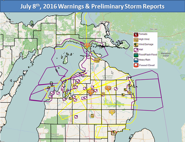
The following image are the issued warnings overlaid with preliminary storm reports from July 8th. A full list of storm reports including time, event, and magnitude follows below.

PRELIMINARY LOCAL STORM REPORT...SUMMARY
NATIONAL WEATHER SERVICE GAYLORD MI
558 PM EDT FRI JUL 08 2016

..TIME...   ...EVENT...      ...CITY LOCATION...     ...LAT.LON...
..DATE...   ....MAG....      ..COUNTY LOCATION..ST.. ...SOURCE....
            ..REMARKS..

1050 AM     HAIL             EMPIRE                  44.81N 86.06W
07/08/2016  E1.75 INCH       LEELANAU           MI   PUBLIC

1051 AM     HAIL             TRAVERSE CITY           44.75N 85.60W
07/08/2016  M1.00 INCH       GRAND TRAVERSE     MI   SPOTTER

1055 AM     HAIL             TRAVERSE CITY           44.75N 85.60W
07/08/2016  E1.00 INCH       GRAND TRAVERSE     MI   SPOTTER

1058 AM     HAIL             GLEN ARBOR              44.90N 86.00W
07/08/2016  E3.00 INCH       LEELANAU           MI   PUBLIC

1104 AM     TSTM WND DMG     WILLIAMSBURG            44.77N 85.40W
07/08/2016                   GRAND TRAVERSE     MI   LAW ENFORCEMENT

            MULTIPLE TREES DOWN AND ROADS CLOSED NEAR BUNKER HILL RD
            AND SUPPLY RD

1117 AM     HAIL             3 N CEDAR               44.89N 85.80W
07/08/2016  E1.50 INCH       LEELANAU           MI   SPOTTER

1120 AM     HAIL             2 S RAPID CITY          44.80N 85.28W
07/08/2016  E1.00 INCH       KALKASKA           MI   SPOTTER

1135 AM     HAIL             12 SE MANCELONA         44.78N 84.89W
07/08/2016  E1.75 INCH       KALKASKA           MI   PUBLIC

1136 AM     HAIL             4 NW BELLAIRE           45.02N 85.26W
07/08/2016  E0.50 INCH       ANTRIM             MI   NWS EMPLOYEE

1140 AM     HAIL             SUTTONS BAY             44.98N 85.65W
07/08/2016  E1.00 INCH       LEELANAU           MI   BROADCAST MEDIA

1144 AM     HAIL             10 SSE MANCELONA        44.77N 84.98W
07/08/2016  E1.50 INCH       KALKASKA           MI   PUBLIC

            MANISTEE LAKES AREA

1149 AM     HAIL             EAST JORDAN             45.16N 85.13W
07/08/2016  E3.00 INCH       CHARLEVOIX         MI   PUBLIC

1152 AM     HAIL             2 NNW EAST JORDAN       45.18N 85.15W
07/08/2016  E1.25 INCH       CHARLEVOIX         MI   CO-OP OBSERVER

1200 PM     HAIL             CENTRAL LAKE            45.07N 85.26W
07/08/2016  E1.00 INCH       ANTRIM             MI   SPOTTER

            1.00 INCH OF RAIN IN 20 MINUTES

1202 PM     TSTM WND GST     CENTRAL LAKE            45.07N 85.26W
07/08/2016  E55.00 MPH       ANTRIM             MI   PUBLIC

1203 PM     TSTM WND GST     4 NNW BELLAIRE          45.03N 85.24W
07/08/2016  E40.00 MPH       ANTRIM             MI   NWS EMPLOYEE

1215 PM     HAIL             5 N FREDERIC            44.86N 84.73W
07/08/2016  E1.50 INCH       CRAWFORD           MI   PUBLIC

1230 PM     HAIL             8 SE GAYLORD            44.95N 84.56W
07/08/2016  E0.50 INCH       OTSEGO             MI   PUBLIC

            MICHAYWE AREA

1243 PM     HAIL             4 NW BELLAIRE           45.02N 85.26W
07/08/2016  E1.00 INCH       ANTRIM             MI   NWS EMPLOYEE

1245 PM     HAIL             2 N SUTTONS BAY         45.01N 85.65W
07/08/2016  E1.00 INCH       LEELANAU           MI   PUBLIC

            1.29 INCHES OF RAIN

1245 PM     HAIL             4 NW BELLAIRE           45.02N 85.26W
07/08/2016  E1.50 INCH       ANTRIM             MI   NWS EMPLOYEE

1248 PM     HAIL             4 NW BELLAIRE           45.02N 85.26W
07/08/2016  E3.00 INCH       ANTRIM             MI   NWS EMPLOYEE

1249 PM     HAIL             2 S LEWISTON            44.85N 84.32W
07/08/2016  E1.00 INCH       MONTMORENCY        MI   SPOTTER

1249 PM     HAIL             4 N BELLAIRE            45.03N 85.21W
07/08/2016  E1.75 INCH       ANTRIM             MI   PUBLIC

0100 PM     HAIL             LEWISTON                44.88N 84.32W
07/08/2016  E1.75 INCH       MONTMORENCY        MI   PUBLIC

0111 PM     HAIL             2 NW ATLANTA            45.02N 84.18W
07/08/2016  E1.00 INCH       MONTMORENCY        MI   SPOTTER

0111 PM     HAIL             3 W KALKASKA            44.73N 85.24W
07/08/2016  E0.25 INCH       KALKASKA           MI   PUBLIC

0118 PM     HAIL             ATLANTA                 45.00N 84.15W
07/08/2016  E1.00 INCH       MONTMORENCY        MI   SPOTTER

0120 PM     HAIL             MACKINAW CITY           45.78N 84.73W
07/08/2016  E0.25 INCH       EMMET              MI   PUBLIC

0144 PM     HAIL             5 S HILLMAN             44.99N 83.90W
07/08/2016  E1.50 INCH       MONTMORENCY        MI   SPOTTER

0150 PM     HAIL             6 S GAYLORD             44.95N 84.67W
07/08/2016  E0.25 INCH       OTSEGO             MI   NWS EMPLOYEE

0150 PM     HAIL             LAKE CITY               44.33N 85.21W
07/08/2016  E1.00 INCH       MISSAUKEE          MI   PUBLIC

0150 PM     HAIL             GAYLORD                 45.03N 84.67W
07/08/2016  E0.25 INCH       OTSEGO             MI   PUBLIC

0206 PM     HEAVY RAIN       9 SSW GAYLORD           44.91N 84.74W
07/08/2016  M1.42 INCH       OTSEGO             MI   OFFICIAL NWS OBS

0207 PM     HAIL             2 E ATLANTA             45.00N 84.11W
07/08/2016  E0.75 INCH       MONTMORENCY        MI   COUNTY OFFICIAL

0209 PM     TSTM WND GST     LEWISTON                44.88N 84.32W
07/08/2016  E65.00 MPH       MONTMORENCY        MI   SPOTTER

0220 PM     TSTM WND DMG     10 SW ALPENA            44.97N 83.58W
07/08/2016                   ALPENA             MI   SPOTTER

            DAMAGE TO FARM BUILDINGS

0227 PM     TSTM WND GST     1 W OSSINEKE            44.91N 83.45W
07/08/2016  M50.00 MPH       ALPENA             MI   SPOTTER

0227 PM     HAIL             ALPENA                  45.07N 83.44W
07/08/2016  E2.00 INCH       ALPENA             MI   SPOTTER
0241 PM     HEAVY RAIN       ATLANTA                 45.00N 84.15W
07/08/2016  M1.80 INCH       MONTMORENCY        MI   SPOTTER

0241 PM     TSTM WND DMG     ALPENA                  45.07N 83.44W
07/08/2016                   ALPENA             MI   SPOTTER

            TREES DOWN
0315 PM     TSTM WND DMG     1 SSE STANDISH          43.97N 83.96W
07/08/2016                   ARENAC             MI   LAW ENFORCEMENT

            SEVERAL TREES AND POWER LINES DOWN FROM
            WORTH TO NORTHEAST OF STANDISH.

0311 PM     TSTM WND GST     1 W OSSINEKE            44.91N 83.45W
07/08/2016  M62 MPH          ALPENA             MI   TRAINED SPOTTER


0310 PM     TSTM WND GST     1 W OSSINEKE            44.91N 83.45W
07/08/2016  M60 MPH          ALPENA             MI   TRAINED SPOTTER


0307 PM     HAIL             STANDISH                43.98N 83.96W
07/08/2016  E1.50 INCH       ARENAC             MI   TRAINED SPOTTER


0257 PM     TSTM WND DMG     4 WSW THE TOWN OF HUBBA 44.85N 83.66W
07/08/2016                   ALCONA             MI   TRAINED SPOTTER

            CAMPER BLOWN OVER. ROOF PEELED OFF OF OUT
            BUILDING.

0230 PM     TSTM WND DMG     1 NE ROSCOMMON COUNTY A 44.37N 84.67W
07/08/2016                   ROSCOMMON          MI   TRAINED SPOTTER

            DAMAGE TO SEVERAL TREES.

0228 PM     NON-TSTM WND GST 1 ESE ROSCOMMON COUNTY  44.35N 84.67W
07/08/2016  M58 MPH          ROSCOMMON          MI   ASOS

            ASOS STATION ROSCOMMON COUNTY AIRPORT /HTL/.
Environment
The overall setup for severe weather across Northern Lower Michigan on July 8th had looked good for a couple of days. At the 12Z (8 am) issuance, SPC placed all of Northern Lower in at least a marginal risk, with the southeast portion of the CWA in a slight. This would be upgraded just after noon, with most of the CWA now in a slight, and areas generally east of US-131 in an enhanced risk.
Moisture availability was very good, with precipitable water values in the neighborhood of 1.4 to 1.5 inches. A look at the sounding climatology puts that just above the 90th percentile of values, with the average for this time of year right around 1 inch. Dewpoints overnight and into the morning held in the low to mid 60s, with some areas on the west side of the state climbing to the upper 60s by 10am. Once again, these values are well above the average of 55°F, and lie somewhere between the 90th percentile and daily maximum.
With the overnight dewpoints remaining in the low to mid 60s, CAPE values were already nearing 1500 J/kg by 10am as temperatures climbed into the low to mid 70s. A quick and simplistic calculation of updraft speeds ((2*CAPE)^1/2)), gives a maximum vertical velocity of around 55 m/s. Certainly enough to support hail formation, but on the lower end of updraft strength spectrum you would expect to see for the formation of large (> 2”) hail.
 |
 |
 |
| 12:30 pm SPC Outlook | 6 am - 4 pm PWAT | 6 am - 4 pm Most Unstable CAPE & Bulk Shear |
Wetbulb zero heights are also often looked at for how favorable an environment is for hail formation. This is the temperature of the environment when the cooling effects of evaporation are taken into consideration. The lower the wetbulb zero height the better, with values less than 10 thousand feet considered ideal. Model soundings from around the area showed the wetbulb zero from 10 to 11 thousand, again not bad but not screaming large hail formation.
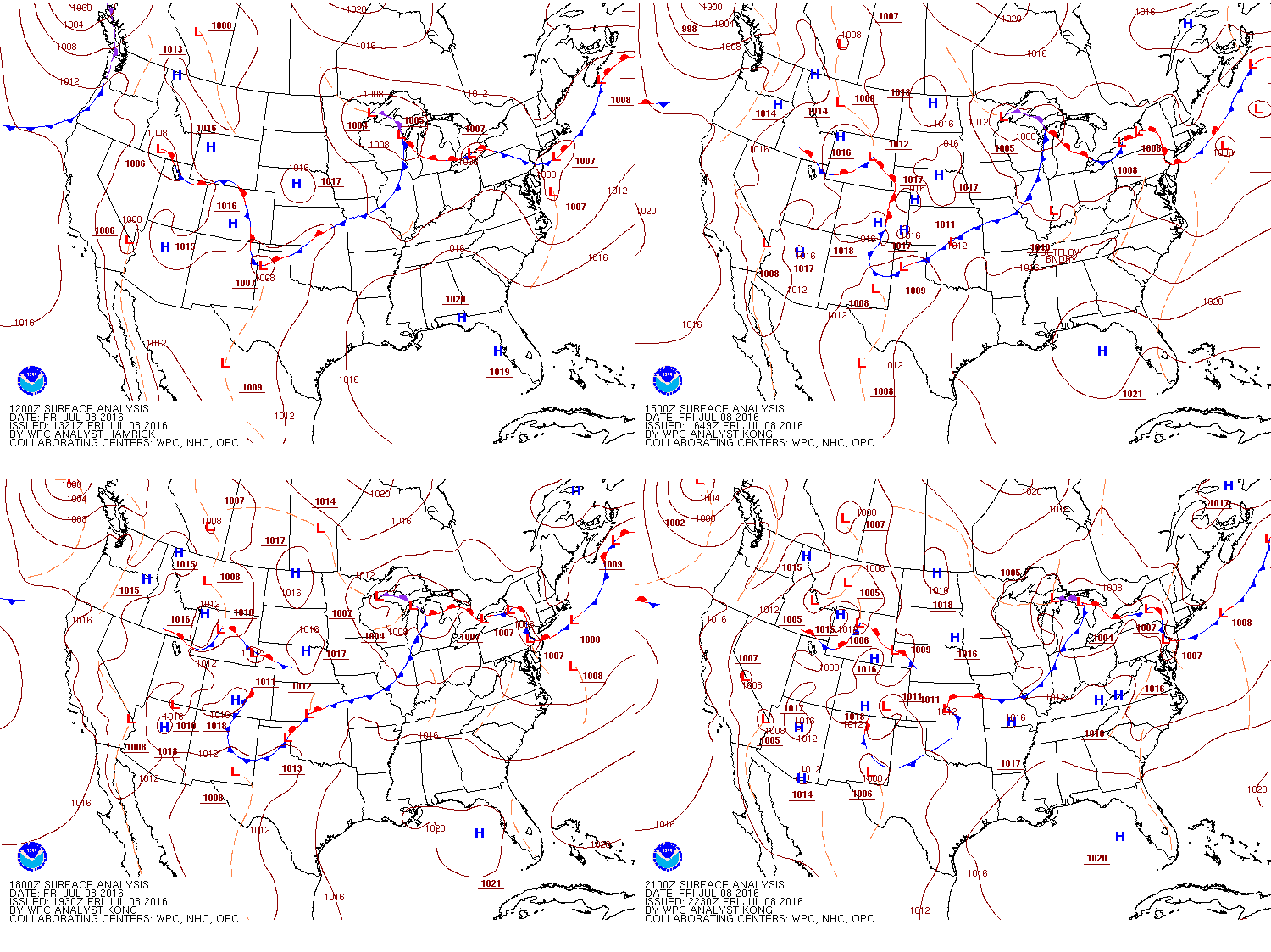
On this occasion, the severe weather was helped along by a couple of features coming through the area at the right time. At the surface, a weakening low pressure system was moving in from northern Wisconsin. This resulted in a warm front setup across central Michigan in the morning, with the triple point (where the warm and cold fronts join) offshore from the Leelenau Peninsula just before 11am, around the time the first warnings went out. The cold front moved through the state through the day, getting to Lake Huron around 5pm. These boundaries helped to produce the lift needed for storms to initiate. Looking aloft, we were also in a favorable location under the jet stream. Divergence aloft aids in upward vertical motion, as nature likes to conserve mass. In a divergent area, mass is leaving and must be replaced, this is done with air from below rushing in, resulting in the upward movement of air. Both the right entrance and left exit region of jets (curvature not considered) are areas of divergence, and as you can see in the 300 mb analysis below, we were located in the left exit region for most of the day.
But perhaps the biggest factor in the severe weather and large hail production was the 500 mb wave that was coming through as well. A strong wave such as this is often what is needed to get widespread severe storms like we saw July 8th. This wave did a few things to help in the severe weather development. Downstream from a trough axis, positive vorticity advection is maximized which enhances vertical motion. Also, the trough took on a small negative tilt (NW to SE orientation) as it moved over the state. This results in diffluent flow aloft, which similar to divergence also enhances vertical motion. But perhaps most importantly, this trough represents height falls and cooler temperatures. 500mb lies within the hail growth region (-10°C to -30°C). So with this influx of cooler air, the lapse rates in this region were steepened. Looking at RAP model soundings, CAPE in the hail growth region was in the 700 to 900 J/kg, nearly half of what the total CAPE was. Many features played a role, but this feature is what really helped develop the large hail.
 |
 |
 |
| WPC Surface Analysis | 6 am - 4 pm 300 mb Analysis | 6 am - 4 pm 700-400 mb Differential Vorticity Advection & 500 mb Height |
 |
Media use of NWS Web News Stories is encouraged! Please acknowledge the NWS as the source of any news information accessed from this site. |
 |