
Thunderstorms, some severe, may produce heavy to excessive rainfall and isolated flooding over portions of the Southern Plains today and Saturday. Dry conditions, combined with gusty winds and low relative humidities will continue to support an elevated to critical fire weather threat in the Desert Southwest into to early next week. Read More >
Memphis
Center Weather Service Unit
Mem_tracon
TRACON PAGES: Memphis Nashville NW Arkansas Little Rock Huntsville Jackson
|
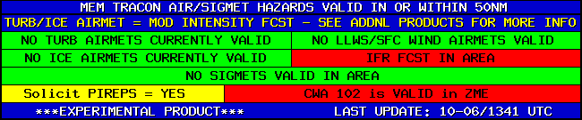
ZME TRACON BRIEFING
CWSU closed between 9:00 PM and 5:15 AM...CWAs will not be updated after 9:00 PM...page will auto-refresh every 5 minutes.. TRACON Briefing Loop Situational Awareness/Webcams
|
Go to New Page with correct radar zoom
| Update ⇒ Pause/Play Last Frame |  |
 |
 |
Flight Category: VFR MVFR IFR LIFR |
Weather Shading: Convective Freezing Winter Smoke/Ash Liquid Fog/Haze |
The above loop uses radar and visible/IR satellite data obtained from Aviation Weather Center (AWC), lightning (GLM) data from NOAA nowCOAST, and observations (for flight category and weather) from MesoWest. The radar, lightning, visible satellite, IR satellite, and flight categories/weather can be toggled on/off. When both the flight category and weather are displayed, the flight category icon will be on the inside and the partially-transparent weather color on the outside. Clicking on the map will start/stop the loop. Left-clicking on the "Speed" area will slow the loop and right-clicking will accelerate the loop, ranging from 0.05 to 5 second interval. Additional URL parameters include lt (center latitude), ln (center longitude), zm (zoom level, 0-12), nolabel (removes flight category icon ID labels), wide (thicken US state boundaries), and start (UTC start date/time, YYYYMMDDhhmm format, AWC data goes back up to 2 days, GLM data up to 5 hours). The URL should auto-update with the current settings, allowing for an easy bookmark/favorite.
US Dept of Commerce
National Oceanic and Atmospheric Administration
National Weather Service
Memphis
3229 Democrat Road
Memphis, TN 38118
Comments? Questions? Please Contact Us.

