Tallahassee, FL
Weather Forecast Office
New River Forecast Services for Santa Fe River


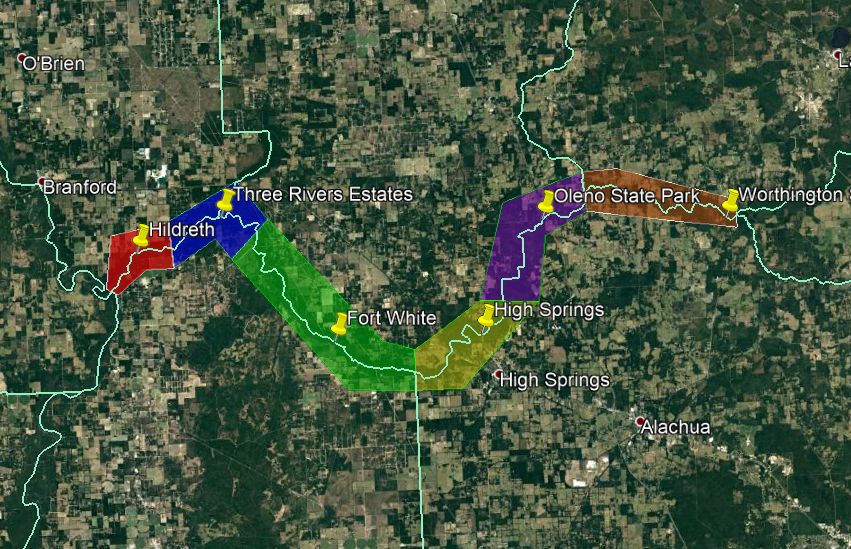
Starting on Thursday, February 1, 2018 the National Weather Service will expand flood only river forecast services for three new locations in the Santa Fe River Basin. These new forecast services will provide additional warning services to the affected areas during times of heavy rainfall across the Santa Fe Basin.
Forecast services for these three new locations are supported by the Southeast River Forecast Center in Peachtree City, Georgia. River flood warnings for these locations are issued by the National Weather Service in Jacksonville, Florida.
River flood warnings are issued whenever the river rises above flood stage. For each of the current and new forecast points on the Santa Fe River, flood stages have been established with graphical areas of impact. These flood warning zones are shown in the image below, referenced to the nearest river forecast point. Note that these zones do not depict areal extent of flood inundation.

As part of this process to provide new forecast services, an in depth review of flood impacts across the basin has been conducted following Hurricane Irma. As a result of this review, flood stages have been modified and additional impact statements created. You can view these changes through these documents listed below:
Santa Fe River at Worthington Springs Santa Fe River at O'leno State Park
Santa Fe River near High Springs Santa Fe River near Fort White
Santa Fe River at Three Rivers Estates Santa Fe River near Hildreth
For questions about these updated and new forecast services in the Santa Fe Basin please contact:
Kelly Godsey Jason Hess
Senior Service Hydrologist/Meteorologist Senior Meteorologist / Hydrology Program Lead
National Weather Service Tallahassee, FL National Weather Service Jacksonville, FL
(850) 942-8833 ext 228 (904) 741-5186
Email Kelly Godsey Email Jason Hess
Current Hazards
Hazardous Weather Outlook
National Outlook
Rip Current Risk
Local Storm Reports (Text)
Local Storm Reports (Map)
Submit a Storm Report
Radar Imagery
National
Florida Panhandle (EVX)
Southwest Alabama (EOX)
Tallahassee (TLH)
Valdosta (VAX)
Current Weather
Observations (Map)
Observations (Text)
Observed Precipitation
Rivers and Lakes
Satellite Images
Upper Air Sounding
Forecasts
Aviation Weather
Fire Weather
Forecast Discussion
Forecast Text Products
Hydrology
Local Model Data
Marine Weather
Tropical Weather
Climate
Climate Text Products
Climate Graphs
CoCoRAHS
Drought
Local Data and Records
ENSO
Tropical Cyclone Reports
US Dept of Commerce
National Oceanic and Atmospheric Administration
National Weather Service
Tallahassee, FL
1017 Academic Way
FSU, Love Bldg, 4th Floor
Tallahassee, FL 32306-4509
850-942-8833 (person) or 850-942-8851 (recording)
Comments? Questions? Please Contact Us.

