Introduction
- New on 2/20/2002: For 209 hours during the calibration and validation periods specified in the DMIP Modeling instructions some data files are missing from the StageIII archive maintained at NWS-HL(link in next paragraph). The StageIII archives maintained at NWS-HL are continually being updated. Tar files containing missing hours for 1994, 1995, 1996, 1997, 1999, and 2000 (through July 31) are now available here (via the anonymous ftp site ftp.nws.noaa.gov/oh/dmip/missing_ppt). These files were obtained directly from ABRFC and reformatted to be consistent with the other files in the NWS-HL archive.
1994_missed.tar.gz
1995_missed.tar.gz
1996_missed.tar.gz
1997_missed.tar.gz (tar file within a tar file)
1999_missed.tar.gz (tar file within a tar file)
2000_missed.tar.gz
- Hourly NEXRAD Stage III products in binary format are available at Hydrology Laboratory, Office of Hydrology Development, National Weather Service. To download hourly NEXRAD Stage III data, click here. Then select ABRFC for Illinois River Basins and Blue River Basin, select OHRFC for Cheat River Basin, select desired YEAR and MONTH. To extract hourly NEXRAD Stage III products, first untar the monthly file to get the daily files, then untar the daily files to get the compressed hourly files and then uncompress the hourly files. Use the UNIX tar and uncompress utilities or equivalent.
Codes to Read XMRG Files
NEXRAD Stage III grids are stored in a binary file format called XMRG. A C program that will read an XMRG file is provided here:
- Code to Read XMRG File on Big Endian machines (Successfully tested on HP UNIX workstations): read_xmrg.c (see program comments for more explanation)
IMPORTANT: XMRG data with corrupted header lines were found in the ABRFC archive for June 1997. At noon on May 17, 2001, the code at this link was modified to read these corrupted files correctly, in addition to all normal XMRG formats. Thus, if you downloaded this code prior to May 17, you should take a look at the recent changes to this code.
- Codes to Read XMRG File on Little Endian machines (Successfully tested on Intel/RedHat Linux machine): read_xmrg_lin.c (see program comments for more explanation), reverse_byte_order.c
The coordinate system that defines the locations of XMRG data values is called the HRAP (Hydrologic Rainfall Analysis Project) grid. An explanation of how to locate the corner of an XMRG data set in HRAP coordinates and how to convert an HRAP cell box coordinate to latitude-longitude coordinates is provided in the header of the read_xmrg.c program. The explanation in this header refers to a FORTRAN subroutine called hrap_to_latlon. A link to hrap_to_latlon and latlon_to_hrap subroutines is provided here:
Checking Your Results
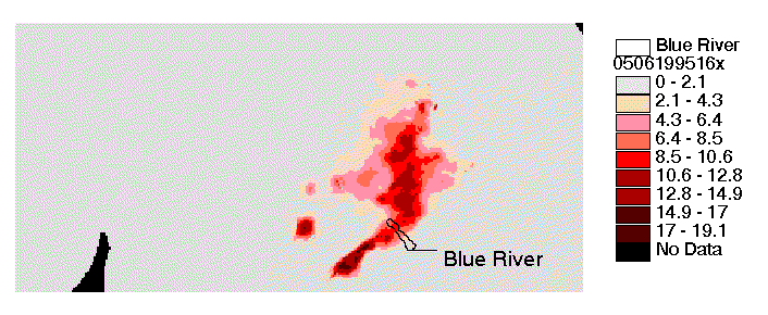
If you wish to check your codes to see if you are getting the same results that we get when reading XMRG files, try reading the data for May 6, 1995 at 16:00 (Single binary file for this hour is provided here: xmrg0506199516z.gz). The mean of non-negative values in this file is 0.766547 mm. The maximum value is 19.1299 mm. A map of the values in this file should look as shown below. Units for the map legend are mm/hour.

Additional Information
The above programs contain all of the information you need to read and use XMRG files. If you really want more information, the following links are provided:
Link to technical specifications for HRAP and XMRG:
https://www.nws.noaa.gov/oh/hrl/pps/pps.htm
Tools for displaying HRAP/XMRG files in ArcView or Arc/Info
https://www.nws.noaa.gov/oh/hrl/distmodel/distmod.htm#tools