Moderate to heavy mountain snow and strong winds are expected across the Northern Rockies. Lake effect snow will continue downwind of the Lower Great Lakes. Gusty winds and dry conditions will result in critical fire weather conditions in the Southwest and Southern Plains Wednesday through Friday. Extremely critical fire weather conditions are expected Thursday in portions of New Mexico. Read More >
|
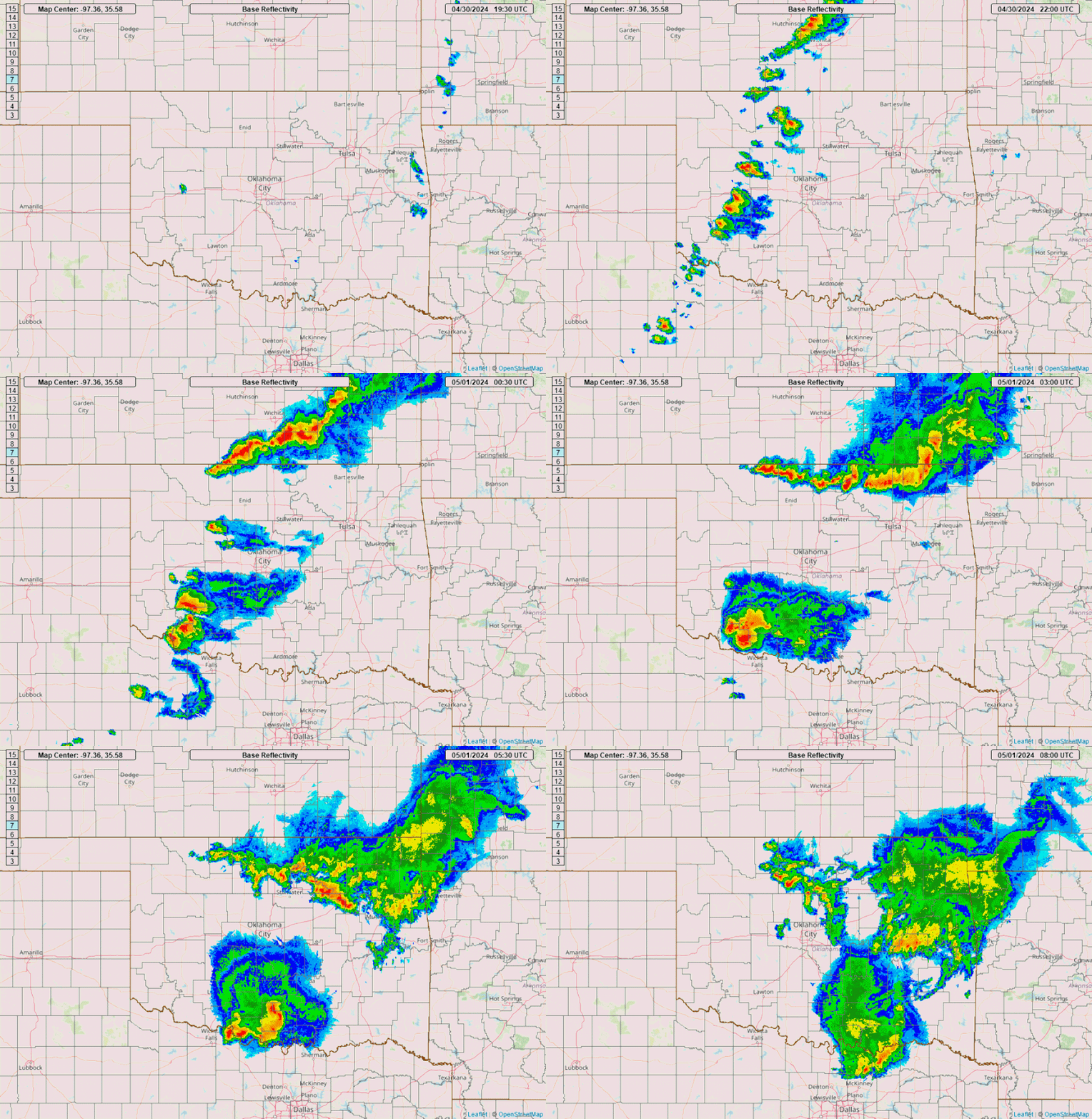
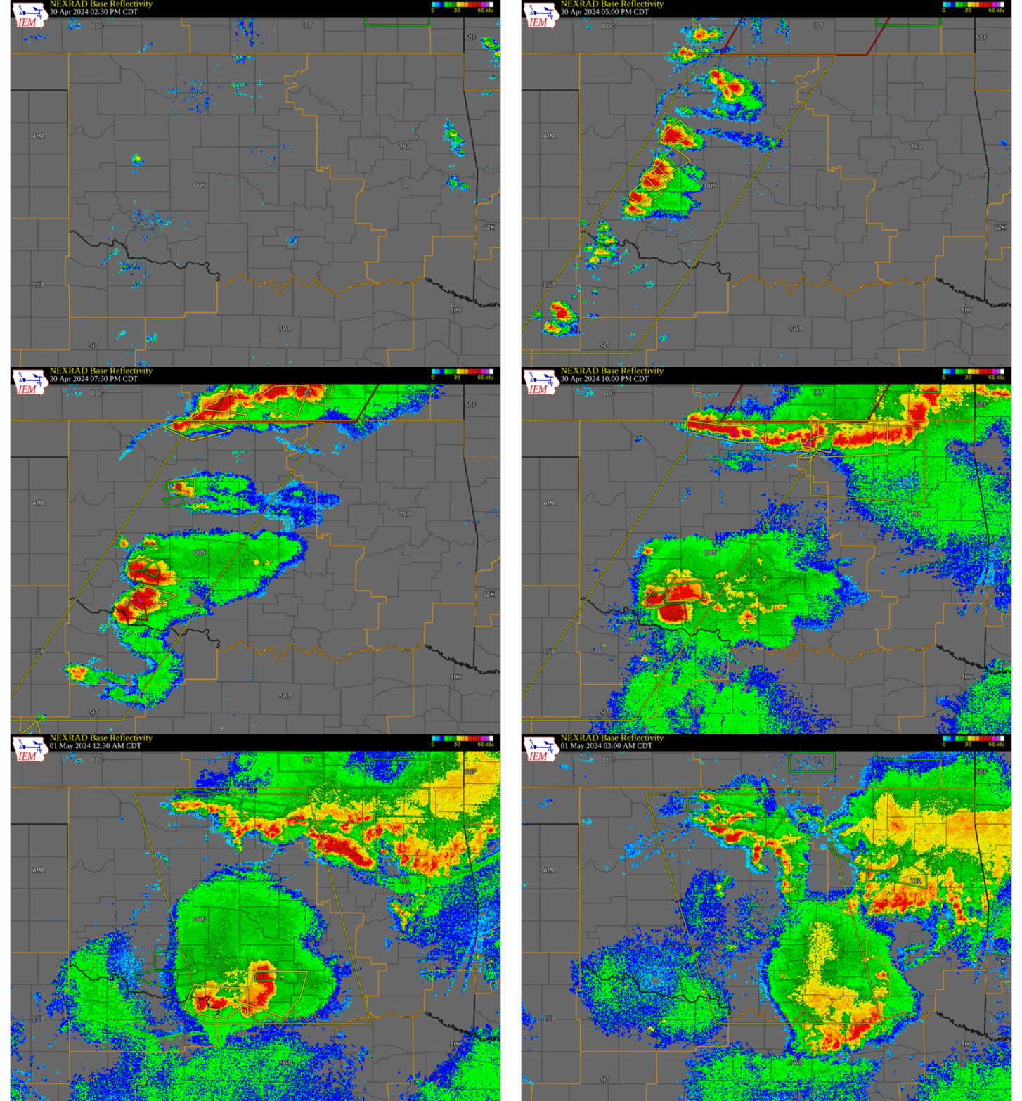
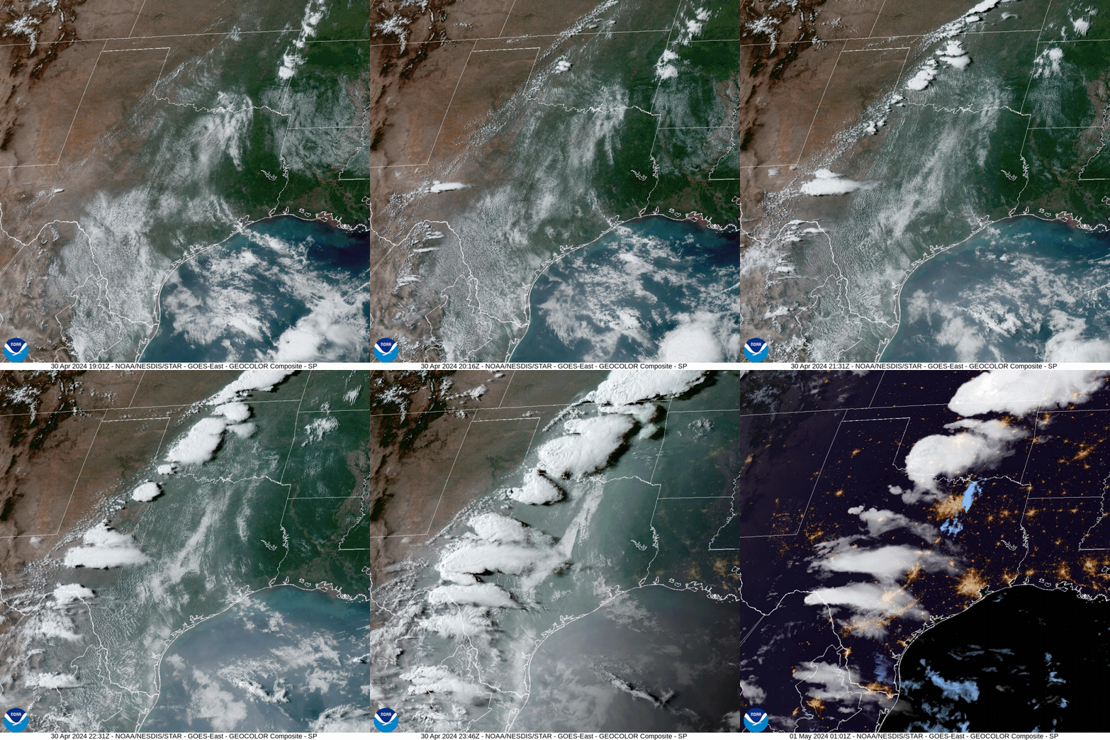
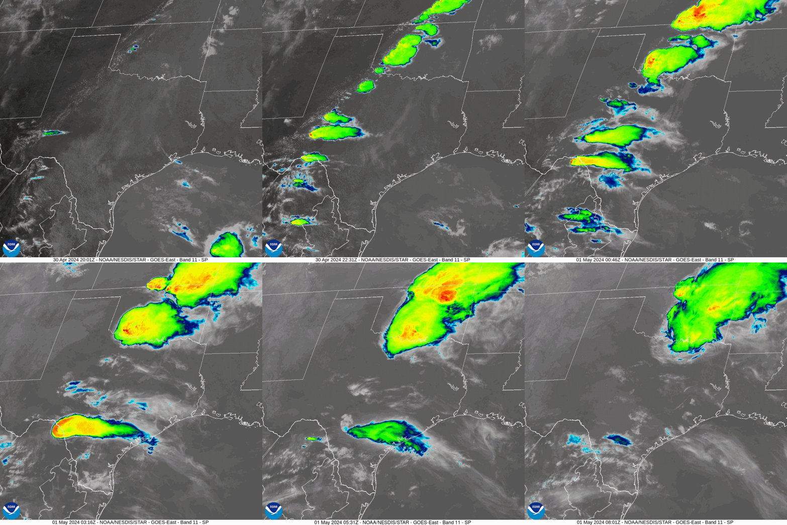
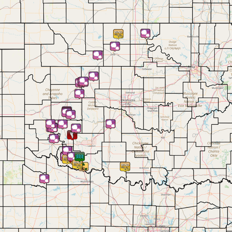
During the midafternoon (~2:30-3:00 pm CDT) of April 30, 2024, thunderstorms began to form along a dryline that stretched from north central Oklahoma into west central and southwestern Oklahoma and also western north Texas in the NWS Norman forecast area. Some of these storms became supercell thunderstorms, and one supercell generated a tornado (rated EF-1) that hit parts of Cordell, OK in Washita County during the late afternoon of April 30th. Large hail (1.0 to 4.4 inches in diameter) was also reported in Blaine, Dewey, Greer, Kiowa, Major, and Washita counties. As the event progressed, some thunderstorms in the middle of the line eventually dissipated by early evening. Around 7 pm CDT, one cluster of storms was located along the OK/KS state line in north central Oklahoma and southern Kansas, and another cluster of thunderstorms were occurring in southwestern Oklahoma. Just a few scattered reports of large hail and severe wind gusts were documented with the northern storms as they moved eastward and out of the NWS Norman forecast area, but these storms also dropped heavy rainfall (2- to 5-inch storm total amounts) in Alfalfa, Garfield, Grant, Kay and Noble counties, prompting the issuance of flash flood warnings. During the evening of April 30th, the group of supercell thunderstorms in southwestern Oklahoma interacted with each other in various ways, and created odd movements in these storms and some of the weak tornadoes that they would produce. A total of 5 tornadoes were documented in Kiowa and Tillman counties, and one was unrated, one was rated EF-0, and three more were rated EF-1. One tornado near Hollister, OK in Tillman County moved east and then northeast and then hooked back to the west-northwest before it dissipated. More reports of large hail (1.0 to 2.0 inches diameter)and severe wind gusts (58 to 62 mph) were received from southwestern Oklahoma during this time. Heavy rainfall amounts of 1.5 to 4 inches occurred in parts of the southwestern Oklahoma, and more flash flood warnings were issued.
|
|
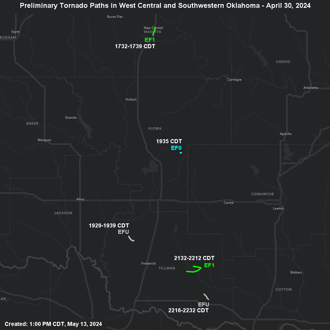
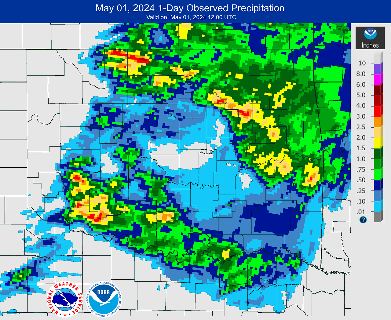
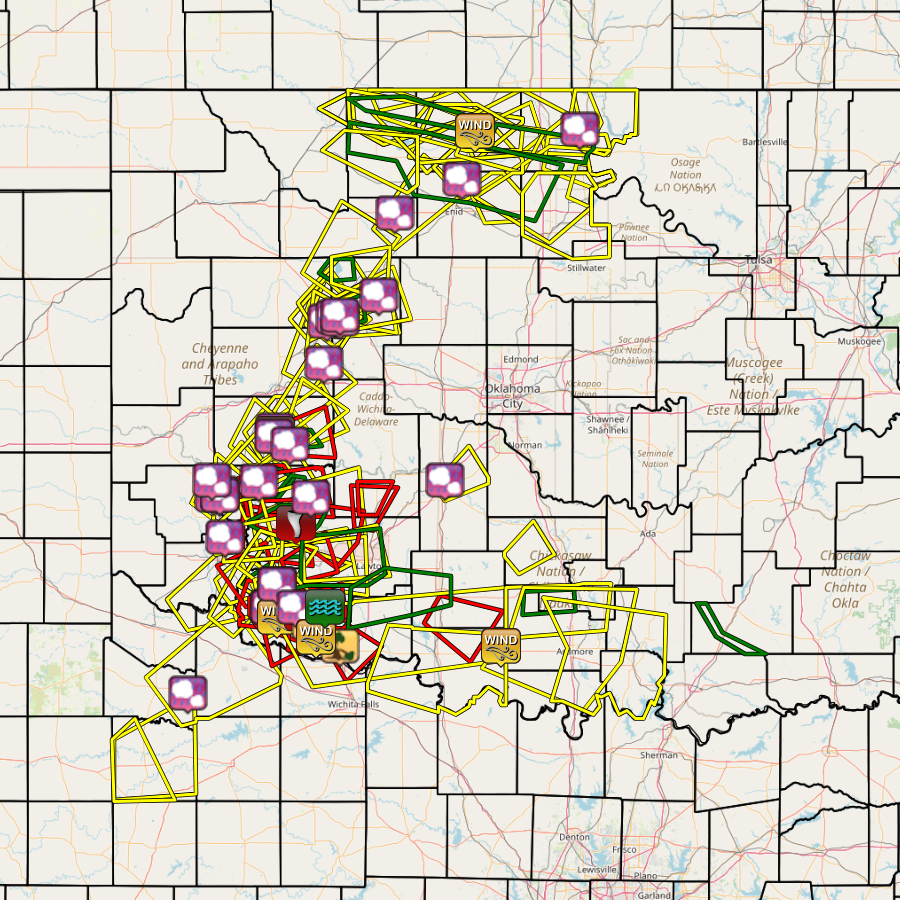
NWS teams conducted storm damage surveys in west central and southwestern Oklahoma during early May 2024 and documented 5 tornadoes that occurred on April 30, 2024. One was unrated, one was rated EF-0, and three more were rated EF-1.
| Tornado Number |
Date | Time (CST) |
Length of Path (miles) |
Width of Path (yards) |
F-Scale | Killed | Injured | County | Location |
|---|---|---|---|---|---|---|---|---|---|
| 1 | 04/30/2024 | 1632-1639 | 2.5 | 200 | EF1 | 0 | 0 | Washita | 1 S Cordell - Cordell - 1 NNE Cordell |
| 2 | 04/30/2024 | 1825-1839 | 2.4 | 50 | EF? | 0 | 0 | Tillman | 4 ESE - 2 E Tipton |
| 3 | 04/30/2024 | 1835-1835 | 0.5 | 100 | EF0 | 0 | 0 | Kiowa | 3 SSE Cooperton |
| 4 | 04/30/2024 | 2032-2112 | 6 | 1200 | EF1 | 0 | 0 | Tillman | 3 NE - 5 NE Hollister |
| 5 | 04/30/2024 | 2118-2132 | 2 | 200 | EF1 | 0 | 0 | Tillman | 2 SSE Loveland - 3 WNW Grandfield |
| Report Date |
Report Time (CST) |
Location | County | State | Event Type |
Mag. | Source | Lat. | Lon. | Remark |
|---|---|---|---|---|---|---|---|---|---|---|
| 04/30/2024 | 14:55 | 2 N Fay | Dewey | OK | Hail | 1.25 in. | Public | 35.84 | -98.67 | Report from mPING: Half Dollar (1.25 in.). |
| 04/30/2024 | 15:19 | 1 ESE Granite | Greer | OK | Hail | 0.88 | Trained Spotter | 34.96 | -99.37 | Spotter Network report. |
| 04/30/2024 | 15:22 | 2 NNW Altus-Lugert Lake | Kiowa | OK | Hail | 1 | Public | 34.96 | -99.33 | Phone call report. |
| 04/30/2024 | 15:23 | 2 NW Altus-Lugert Lake | Kiowa | OK | Hail | 1.25 in. | Public | 34.97 | -99.33 | Report from mPING: Half Dollar (1.25 in.). |
| 04/30/2024 | 15:27 | 2 NNW Altus-Lugert Lake | Kiowa | OK | Hail | 1.50 in. | Public | 34.96 | -99.33 | Phone call report. |
| 04/30/2024 | 15:35 | Ringwood | Major | OK | Hail | 0.88 in. | Emergency Mngr | 36.38 | -98.25 | |
| 04/30/2024 | 15:35 | 5 N Granite | Greer | OK | Hail | 1.50 in. | Emergency Mngr | 35.04 | -99.38 | Relayed image. Radar estimated time. |
| 04/30/2024 | 16:11 | Kremlin | Garfield | OK | Hail | 1.00 in. | Emergency Mngr | 36.55 | -97.83 | |
| 04/30/2024 | 16:19 | 3 NE Fay | Blaine | OK | Hail | 1.75 in. | Public | 35.86 | -98.62 | Report from mPING: Golf Ball (1.75 in.). |
| 04/30/2024 | 16:21 | Cordell | Washita | OK | Hail | 1.00 in. | Public | 35.29 | -98.99 | Report from mPING: Quarter (1.00 in.). |
| 04/30/2024 | 16:24 | 7 N Weatherford | Custer | OK | Hail | 1.00 in. | Public | 35.63 | -98.69 | Report from mPING: Quarter (1.00 in.). |
| 04/30/2024 | 16:25 | 2 S Cordell | Washita | OK | Hail | 1.75 in. | Public | 35.26 | -98.99 | Report from mPING: Golf Ball (1.75 in.). |
| 04/30/2024 | 16:30 | 2 S Cordell | Washita | OK | Tornado | Broadcast Media | 35.27 | -98.99 | Multiple visual reports. Damage reported in Cordell. Additional details pending. Radar estimated time. | |
| 04/30/2024 | 16:31 | 2 SW Cordell | Washita | OK | Hail | 2.50 in. | Public | 35.26 | -99.00 | Report from mPING: Tennis Ball (2.50 in.). |
| 04/30/2024 | 16:44 | 4 WSW Cloud Chief | Washita | OK | Hail | 3.00 in. | Broadcast Media | 35.22 | -98.90 | |
| 04/30/2024 | 16:45 | 4 ENE Fay | Blaine | OK | Hail | 3.73 in. | Trained Spotter | 35.85 | -98.59 | Digital caliper measurement. Radar estimated time. |
| 04/30/2024 | 16:45 | 4 S Eagle City | Blaine | OK | Hail | 4.40 in. | Trained Spotter | 35.87 | -98.59 | Digital caliper measurement. Radar estimated time. |
| 04/30/2024 | 16:48 | Hobart | Kiowa | OK | Hail | 1.25 in. | Public | 35.03 | -99.09 | Report from mPING: Half Dollar (1.25 in.). |
| 04/30/2024 | 17:33 | 3 S Thalia | Foard | TX | Hail | 1.00 in. | Public | 33.95 | -99.53 | Report from mPING: Quarter (1.00 in.). |
| 04/30/2024 | 18:19 | Manitou | Tillman | OK | Hail | 1.00 in. | Fire Dept/Rescue | 34.51 | -98.98 | |
| 04/30/2024 | 18:35 | 3 S Cooperton | Kiowa | OK | Tornado | Trained Spotter | 34.82 | -98.86 | Multiple social media images. Additional details pending. Radar estimated time. | |
| 04/30/2024 | 18:58 | 8 NE Cooperton | Kiowa | OK | Hail | 2.00 in. | Public | 34.95 | -98.77 | 1.9 inch diameter hail reported by trained storm spotter. |
| 04/30/2024 | 19:08 | 1 NE Frederick | Tillman | OK | Hail | 1.00 in. | Public | 34.40 | -99.01 | Report from mPING: Quarter (1.00 in.). |
| 04/30/2024 | 19:11 | 1 W Frederick | Tillman | OK | Hail | 1.00 in. | Emergency Mngr | 34.39 | -99.03 | |
| 04/30/2024 | 19:12 | Frederick | Tillman | OK | Hail | 1.50 in. | Emergency Mngr | 34.39 | -99.02 | |
| 04/30/2024 | 19:20 | Frederick | Tillman | OK | Hail | 2.00 in. | Trained Spotter | 34.39 | -99.02 | Social media image. |
| 04/30/2024 | 19:35 | 1 SW Medford | Grant | OK | Tstm Wnd Gust | 66 mph | Mesonet | 36.79 | -97.75 | Medford Mesonet. |
| 04/30/2024 | 19:45 | 3 SE Blair | Jackson | OK | Hail | 1.75 in. | Public | 34.75 | -99.30 | Report from mPING: Golf Ball (1.75 in.). Radar estimated time. |
| 04/30/2024 | 19:56 | Manitou | Tillman | OK | Hail | 1.75 in. | Emergency Mngr | 34.51 | -98.98 | |
| 04/30/2024 | 20:28 | 3 W Kildare | Kay | OK | Hail | 1.25 in. | Public | 36.80 | -97.10 | Report from mPING: Half Dollar (1.25 in.). |
| 04/30/2024 | 20:33 | 4 SSE Frederick | Tillman | OK | Tstm Wnd Gust | 63 mph | ASOS | 34.34 | -98.98 | KFDR. |
| 04/30/2024 | 20:42 | 4 ENE Hollister | Tillman | OK | Tornado | Trained Spotter | 34.36 | -98.81 | TDS noted along with visual confirmation. Additional details pending. | |
| 04/30/2024 | 21:15 | Manitou | Tillman | OK | Hail | 1.75 in. | Emergency Mngr | 34.51 | -98.98 | |
| 04/30/2024 | 21:20 | 1 NNE Loveland | Tillman | OK | Tstm Wnd Dmg | Public | 34.31 | -98.77 | Damage to fence and roof partially removed from barn. Also occasional tree damage. | |
| 04/30/2024 | 21:21 | 3 SE Loveland | Tillman | OK | Tornado | Official NWS Obs | 34.27 | -98.74 | TDS noted. Additional details pending. | |
| 04/30/2024 | 21:32 | 3 N Hollister | Tillman | OK | Hail | 1.00 in. | Public | 34.39 | -98.86 | Report from mPING: Quarter (1.00 in.). |
| 04/30/2024 | 21:45 | 3 W Grandfield | Tillman | OK | Tstm Wnd Gust | 58 mph | Mesonet | 34.24 | -98.74 | Grandfield Mesonet. |
| 04/30/2024 | 21:50 | Devol | Cotton | OK | Tstm Wnd Dmg | Storm Chaser | 34.19 | -98.59 | Social media image showing a tree uprooted. Radar estimated time. | |
| 04/30/2024 | 22:10 | 3 W Grandfield | Tillman | OK | Tstm Wnd Gust | 59 mph | Mesonet | 34.24 | -98.74 | Grandfield Mesonet. |
| 04/30/2024 | 22:48 | 3 SSW Chattanooga | Tillman | OK | Flash Flood | Emergency Mngr | 34.39 | -98.68 | Report of water across portions of Oklahoma State Highway 5. | |
| 04/30/2024 | 23:00 | 1 N Ringling | Jefferson | OK | Tstm Wnd Gust | 62 mph | Mesonet | 34.19 | -97.59 | Ringling Mesonet. |
| 05/01/2024 | 03:36 | Hitchcock | Blaine | OK | Hail | 1.00 in. | Emergency Mngr | 35.97 | -98.35 | |
| 05/01/2024 | 05:00 | Chickasha | Grady | OK | Hail | 1.00 in. | Emergency Mngr | 35.04 | -97.94 |
