
Excessive rainfall may produce locally considerable flash flooding over parts of the northwestern Gulf Coast, lower Mississippi River Valley, and Deep South through Thursday. Potential Tropical Cyclone One is forecast to become a tropical storm (Arthur) as it moves along or just off the northwestern Gulf coast through Wednesday. An outbreak of severe weather is forecast in the Midwest Wednesday. Read More >

| Washita County, OK Tornadoes Prior to 1950 | |||||||||
| # | Date | Time (CST) |
Path Length (miles) |
Path Width (yards) |
F-Scale | Killed | Injured | County | Path |
|---|---|---|---|---|---|---|---|---|---|
| 05/23/1903 | Aft | 0 | Washita | "Burns" (just N of Burns Flat) | |||||
| 04/27/1912 | 1230 | 85 | 880 | 15 | 39 | Kiowa/ Washita/ Caddo/ Canadian | Lugert - near Hobart - Colony - near Hinton - near Calumet | ||
| 04/27/1912 | 1400 | 880 | 0 | 2 | Washita | Rocky | |||
| 04/27/1912 | 2045 | 12 | Kiowa/ Washita | Near Hobart - near Sentinel | |||||
| 04/28/1912 | 0130 | 2 | 2 | Washita | Sentinel | ||||
| 06/05/1936 | 1700 | 1 | 50 | 1 | 0 | Washita | Corn | ||
| 04/09/1944 | 1730 | 14 | 1 | 10 | Washita | Near Cordell and Cloud Chief | |||
| 06/26/1946 | 1845 | 440 | 0 | 0 | Washita | Near Cowden | |||
| 10/09/1949 | 2315 | 16 | 440 | 0 | 0 | Beckham/ Washita | Elk City - near Canute - near Foss | ||
| Washita County, OK Tornadoes (1950-Present*) | |||||||||
| # | Date | Time (CST) |
Path Length (miles) |
Path Width (yards) |
F-Scale | Killed | Injured | County | Path |
| 1 | 04/28/1950 | 1417 | 21 | 400 | F3 | 1 | 1 | Kiowa/ Washita | near Lugert (15 SW Hobart) - near Lone Wolf - near Sentinel |
| 2 | 06/08/1951 | 1830 | 11 | 173 | F3 | 0 | 0 | Washita | Corn - Colony - 3 ESE Colony |
| 3 | 04/22/1957 | 1901 | 0.1 | 10 | F1 | 0 | 0 | Washita | SW of Sentinel |
| 4 | 05/22/1957 | 0615 | 15 | 10 | F2 | 0 | 0 | Kiowa/ Washita/ Caddo | 5 SW Mountain View - near Eakly |
| 5 | 05/04/1959 | 2200 | 0.1 | 10 | F1 | 0 | 0 | Washita | S of Sentinel |
| 6 | 05/25/1962 | 1605 | 0.1 | 10 | F0 | 0 | 0 | Washita | 13 E Elk City |
| 7 | 05/25/1962 | 1825 | 0.1 | 10 | F0 | 0 | 0 | Washita | 11 NNE Cordell |
| 8 | 05/25/1962 | 1828 | 7 | 250 | F4 | 0 | 9 | Washita | 3 W Dill City- Dill City- 4 W Cordell |
| 9 | 05/26/1962 | 1745 | 0.1 | 10 | F? | 0 | 0 | Washita | 4 W Sentinel |
| 10 | 09/11/1963 | 1745 | 0.1 | 10 | F1 | 0 | 0 | Washita | Near Foss |
| 11 | 11/06/1964 | 1130 | 0.1 | 10 | F0 | 0 | 0 | Washita | 1 ESE Sentinel |
| 12 | 04/04/1965 | 1710 | 4 | 33 | F2 | 0 | 0 | Washita | 1.5 E- 5 ENE Dill City |
| 13 | 06/08/1966 | 1800 | 0.1 | 10 | F0 | 0 | 0 | Washita | Just East of Cowden |
| 14 | 06/11/1970 | 1200 | 0.1 | 10 | F1 | 0 | 0 | Washita | Near Colony |
| 15 | 06/07/1971 | 1900 | 0.1 | 10 | F0 | 0 | 0 | Washita | 4 N Cordell |
| 16 | 05/22/1972 | 2027 | 1.9 | 33 | F1 | 0 | 0 | Washita | Near Cordell |
| 17 | 03/27/1975 | 0230 | 20 | 150 | F1 | 0 | 0 | Beckham/ Washita/ Custer | 10 SW- 10 NE Elk City |
| 18 | 05/02/1975 | 1530 | 5 | 150 | F3 | 0 | 0 | Washita | 1 NW Rocky - 4 NE Rocky |
| 19 | 05/02/1975 | 1540 | 0.8 | 100 | F1 | 0 | 0 | Washita | 8 SE Cordell |
| 20 | 04/17/1976 | 0350 | 5 | 30 | F1 | 0 | 0 | Washita | 10 NW Mountain View |
| 21 | 06/12/1977 | 1200 | 2 | 50 | F1 | 0 | 0 | Washita | 4 WSW Dill City |
| 22 | 06/12/1977 | 1225 | 6 | 77 | F1 | 0 | 0 | Washita | 5 WNW- 8 NNW Cordell |
| 23 | 06/12/1977 | 1225 | 6 | 77 | F1 | 0 | 0 | Washita | 5 WNW Cordell... then merger with other tornado |
| 24 | 07/23/1979 | 1430 | 0.1 | 10 | F1 | 0 | 0 | Washita | Near Lake Valley |
| 25 | 05/20/1980 | 2130 | 0.1 | 10 | F0 | 0 | 0 | Washita | NW of Carnegie |
| 26 | 05/22/1981 | 1617 | 7 | 200 | F2 | 0 | 0 | Washita | 2 NW Cordell - E of Bessie |
| 27 | 05/22/1981 | 1725 | 1 | 50 | F1 | 0 | 0 | Washita | 2 E Lake Valley |
| 28 | 05/22/1981 | 1807 | 5 | 300 | F2 | 0 | 0 | Washita/ Caddo | 3 ESE- ~6 ENE Cowden |
| 29 | 05/22/1981 | 1830 | 15 | 100 | F2 | 0 | 0 | Kiowa/ Washita/ Caddo | N of Mountain View - 6 N Alfalfa |
| 30 | 05/11/1982 | 1822 | 7 | 50 | F2 | 0 | 0 | Washita | 4 SW Sentinel - S of Port |
| 31 | 05/11/1982 | 1900 | 0.1 | 10 | F0 | 0 | 0 | Washita | ~3 E Burns Flat |
| 32 | 06/13/1983 | 1800 | 0.1 | 10 | F0 | 0 | 0 | Washita | 11 SSW Cordell |
| 33 | 03/17/1986 | 1755 | 34 | 100 | F1 | 0 | 0 | Greer/ Beckham/ Washita | 2 W Plainview- S of Delhi- 5 S Carter- N of Retrop- 2 N Canute |
| 34 | 05/16/1986 | 2000 | 0.2 | 23 | F0 | 0 | 0 | Washita | 1.5 N Dill City |
| 35 | 10/01/1986 | 2025 | 0.1 | 30 | F0 | 0 | 0 | Washita | 2 S Canute |
| 36 | 06/06/1994 | 2029-2045 | 6 | 150 | F1 | 0 | 2 | Custer/ Washita | 5 NNW Foss- 0.5 S Foss |
| 37 | 04/02/1999 | 2050-2052 | 1.1 | 25 | F1 | 0 | 0 | Washita | Dill City |
| 38 | 03/07/2000 | 1715-1719 | 2 | 20 | F1 | 0 | 0 | Washita | 5 E - 7 E Sentinel |
| 39 | 05/26/2000 | 1812-1828 | 3 | 20 | F0 | 0 | 0 | Washita/ Caddo | 2 SSE - 3 ESE Colony (3 W Eakly) |
| 40 | 05/05/2001 | 1911 | 0.1 | 15 | F0 | 0 | 0 | Washita | 2 N Cordell |
| 41 | 05/05/2001 | 1915-1919 | 0.5 | 75 | F0 | 0 | 0 | Washita | 4 NNE Cordell |
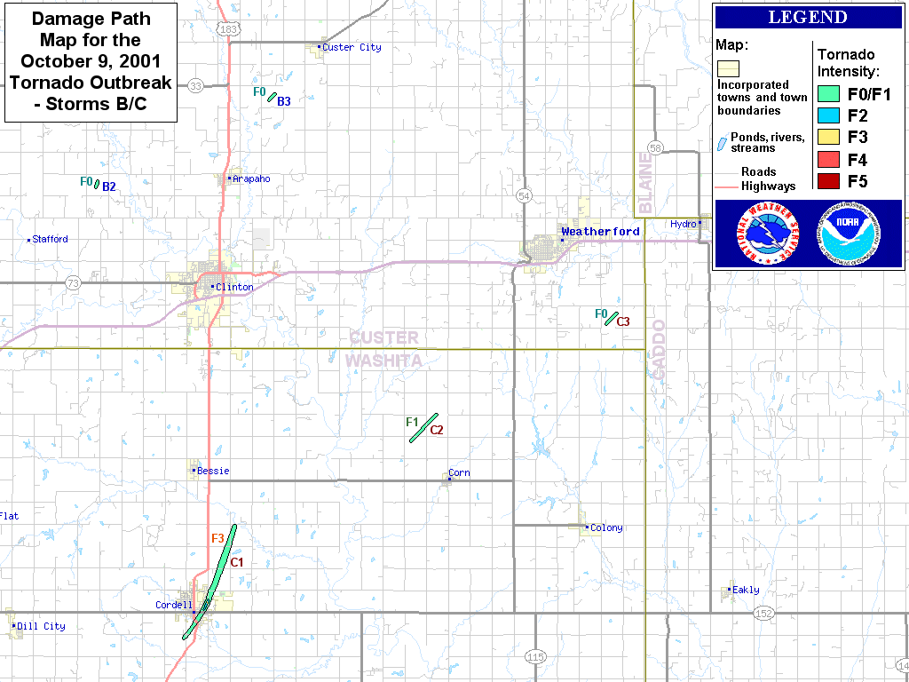
| 42 | 10/09/2001 | 1530-1556 | 12 | 600 | F3 | 0 | 0 | Beckham/ Washita/ Custer | NE side of Elk City (2 NE Elk City) - 2.5 W Foss Reservoir Dam (7.5 SSW Butler) |
| 43 | 10/09/2001 | 1608-1621 | 6 | 500 | F3 | 0 | 9 | Washita | 1.5 SSW Cordell - Cordell - 3.5 NNE Cordell |
| 44 | 10/09/2001 | 1632-1636 | 2 | 200 | F1 | 0 | 0 | Washita | 2.5 NW - 3 NNW Corn |
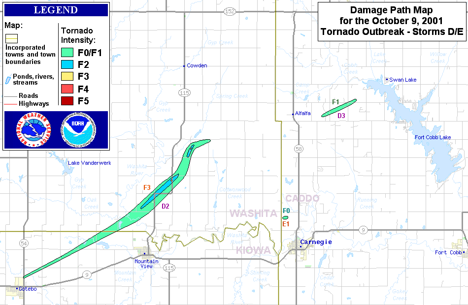
| 45 | 10/09/2001 | 1636-1710 | 13 | 440 | F3 | 0 | 1 | Kiowa/ Washita | 1 N Gotebo - 4.5 SSE Cowden (7 NNE Mountain View) |
| 46 | 05/24/2002 | 1727-1729 | 0.2 | 25 | F0 | 0 | 0 | Washita | 3 SE Burns Flat |
| 47 | 08/18/2007 | 1610-1620 | 4 | 30 | EF0 | 0 | 0 | Washita | 10 SSE - 6 SSE Cordell |
| 48 | 05/12/2010 | 1921-1935 | 10 | 50 | EF1 | 0 | 0 | Washita/ Custer | 7 S - 6 ENE Clinton |
| 49 | 05/16/2017 | 1746-1818 | 18 | 1000 | EF2 | 1 | 10 | Beckham/ Washita | 3 NW Carter - Elk City (S side) - 3 WSW Canute |
| 50 | 05/18/2017 | 1429-1437 | 6 | 100 | EF1 | 0 | 0 | Washita | 6 ENE Rocky - 2.5 SW Cloud Chief |
| 51 | 05/18/2017 | 1440 | 0.5 | 100 | EF? | 0 | 0 | Washita | 2.5 NNW Cloud Chief |
| 52 | 05/18/2017 | 1540 | 0.3 | 50 | EF? | 0 | 0 | Washita | 4 N Cloud Chief |
| 53 | 05/07/2019 | 2232-2255 | 9 | 400 | EF2 | 0 | 0 | Washita | 2.5 S Rocky - Rocky - 3.5 SSW Cordell |
| 54 | 05/07/2019 | 2246-2248 | 0.5 | 40 | EF? | 0 | 0 | Washita | 5 SSW Cordell |
| 55 | 10/12/2021 | 1824 | 0.1 | 25 | EF? | 0 | 0 | Washita | 3 S Foss |
| 56 | 04/30/2024 | 1632-1639 | 2.5 | 200 | EF1 | 0 | 0 | Washita | 1 S Cordell - Cordell - 1 NNE Cordell |
| 57 | 11/18/2024 | 0348-0351 | 2.4 | 30 | EF? | 0 | 0 | Kiowa/ Washita | 6 SE - 4 SE Retrop |
| 58 | 11/18/2024 | 0420-0421 | 1 | 50 | EF? | 0 | 0 | Washita | 5 E Burns Flat |
| Date | Time (CST) |
Path Length (miles) |
Path Width (yards) |
F-Scale | Killed | Injured | County | Path | |
|---|---|---|---|---|---|---|---|---|---|
| 04/28/1950 | 1417 | 21 | 400 | F3 | 1 | 1 | Kiowa/ Washita | Near Lugert (15 SW Hobart) - near Lone Wolf - near Sentinel | |
|
This tornado touched down in the vicinity of Altus-Lugert Lake about 15 miles southwest of Hobart in Kiowa County, and progressed north-northeasterly to near Lone Wolf. It then turned more northerly and dissipated near Sentinel in Washita County. The tornado traveled along a 21-mile path. Five homes were demolished and another 6 were damaged. A total of 17 farms were damaged. One person was killed and another person injured. Property loss was estimated at $100,000. |
|||||||||
| 05/25/1962 | 1828 | 7 | 250 | F4 | 0 | 9 | Washita | 3 W Dill City- Dill City- 4 W Cordell | |
|
This tornado touched down onto two farms three miles west of Dill City, destroying buildings and killing 400 turkeys. As the twister moved eastward toward Dill City, it was observed without a full condensation funnel. The tornado was spotted by a Highway Patrol Unit at 6:20 pm CST west of the city. The storm was described by witnesses as having two distinct vortices rotating within the main tornado circulation. The tornado was observed with a full condensation funnel as it approached the west edge of town at 6:28 pm CST. The tornado cut a 750-yard damage swath across the northern part of Dill City before continuing east, causing destruction to farms for another 3 miles before it veered to the north. The tornado then traveled across OK State Highway 152, about 5 miles west of Cordell, and headed northeast. It continued for 1 more mile, demolishing all buildings on a farm, before it dissipated. Nine people were injured from the storm, although no serious injuries were reported. The toll of damage along the 7-mile path included 29 homes (including 2 trailer homes) destroyed. A total 12 more homes received major damage while 13 had minor damage, and 7 farm buildings were destroyed. A total of 60 families were affected by the damage. Thirty-five vehicles were lost, trees were snapped, and 26 utility poles downed. |
|||||||||
| 06/06/1994 | 2029-2045 | 6 | 150 | F1 | 0 | 2 | Custer/ Washita | 5 NNW Foss- 0.5 S Foss | |
|
Thunderstorms developed in west-central Oklahoma during the evening hours of June 6th and moved into portions of southern Oklahoma. These storms produced a tornado, hail up to 2 inches in diameter, damaging winds, damaging lightning and flash flooding rains. This tornado developed at 8:29 pm CST 5 miles north-northwest of Foss and moved south-southeast 5.5 miles before dissipating 0.5 miles south of Foss. This F1 tornado tore a section of the roof off an abandoned gas station, blew a pickup from a parking lot in a truck stop onto U.S. Interstate Highway I-40, overturned 4 cars and 4 tractor trailers on U.S. Interstate Highway I-40 closing both directions of travel for several hours. The tornado also destroyed a mobile home, damaged an antenna, the roof of a hay barn, a flagpole, a travel trailer and the roofs of homes, blew the windows out of a restaurant, tore a section of a roof off a boat storage building, damaged or destroyed several signs, uprooted trees, and broke off tree limbs. Two people received minor injuries when the vehicle they were in was overturned on U.S. Interstate Highway I-40. |
|||||||||
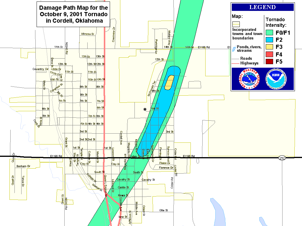
| 10/09/2001 | 1608-1621 | 6 | 500 | F3 | 0 | 9 | Washita | 1.5 SSW Cordell - Cordell - 3.5 NNE Cordell | |
|
A major tornado outbreak occurred across western Oklahoma during the afternoon and early evening of October 9th. Nineteen tornadoes were confirmed, with three rated F3. The first F3 tornado developed in northeast Beckham County, near Elk City, and tracked northeastward for 11 miles before dissipating. As the tornado entered Custer County, a home of wood frame with brick exterior had most of its interior and exterior walls destroyed. The tornado then continued across an unpopulated area, causing major damage to trees and fences, before dissipating 2.5 miles west of Foss Dam. The second F3 tornado developed in Washita County, near Cordell. The Oklahoma State Emergency Management Office estimated that 477 single-family homes were damaged, 132 considered uninhabitable. In addition, 40 businesses were damaged, 22 considered uninhabitable. Damage was estimated near 100 million dollars, and nine injuries were reported. The last F3 tornado developed in Kiowa County and produced F3 damage soon after entering Washita County. Several vehicles and large pieces of farm equipment were tossed and destroyed. About 4 miles north-northeast of Mountain View, 3 homes suffered major damage, with one rated F3. As the tornado continued northeastward, F3 damage was inflicted on a farm, where a house and several barns and outbuildings were leveled. A 10,000-gallon diesel tank ended up in an open field about one-quarter mile away from its original position. For simplicity, the tornadoes that occurred on this day were identified by the supercell thunderstorm that produced them, beginning with A and ending with E. Each tornado was then given its own number. For example, the 3rd tornado produced by supercell thunderstorm A is called A3. In addition, some tornadoes tracked across multiple counties. Tornado C1: This tornado developed on the southwest side of Cordell, where a mobile home and metal warehouse were blown into a farmhouse. The tornado then moved through the south, east and northeast portions of Cordell, including a business district and a large residential area. Most damage south of Main Street was rated F0 or F1. North of Main Street, the damage path widened to approximately 500 yards, with the tornado then inflicting widespread F1 to F2 damage up to 12th Street. Hundreds of homes were damaged in this area. As the tornado began to exit the northeast side of Cordell, F3 damage was sustained to several homes on 9th Street, just west of Crider Road. An F4 rating was considered; however, the structural integrity of most structures was at or below average, and was taken into consideration. Another interesting note is that several eye-witnesses reported that the tornado was widest and contained the most violent-looking winds at this time. The tornado eventually exited Cordell and dissipated 3.5 miles northeast of town. The Oklahoma State Emergency Management Office estimated that 477 single-family homes were damaged, 132 considered uninhabitable. In addition, 40 businesses were damaged, 22 considered uninhabitable. Damage was estimated near 100 million dollars, and nine injuries were reported. |
|||||||||
| 10/09/2001 | 1636-1710 | 13 | 440 | F3 | 0 | 1 | Kiowa/ Washita | 1 N Gotebo - 4.5 SSE Cowden (7 NNE Mountain View) | |
|
See the narrative for the previous tornado for a summary of the October 9, 2011 tornado outbreak. Tornado D2, Kiowa County portion: This multiple-vortex tornado developed 1 mile north of Gotebo, resulting in mostly minor tree damage before crossing into Washita County at 1649 CST. F1 damage was observed, however, 5 miles west of Mountain View, where a wood-frame barn was heavily damage. Tornado D2, Washita County portion: Extensive tree damage was observed from the Kiowa/Washita County border, northeastward to near State Highway 115, where the tornado leveled (rated F2) the Oakdale Schoolhouse, an old structure built in the 1920s. Across the street from the schoolhouse, a diesel shop was leveled, along with a barn, garage, and an unanchored wood-floor home. Several vehicles and large pieces of farm equipment were also tossed and destroyed. About 4 miles north-northeast of Mountain View, 3 homes suffered major damage, with one rated F3. As the tornado continued northeastward, F3 damage was inflicted on a farm, where a house and several barns and outbuildings were leveled. A 10,000-gallon diesel tank ended up in an open field about one-quarter mile away from its original position. |
|||||||||
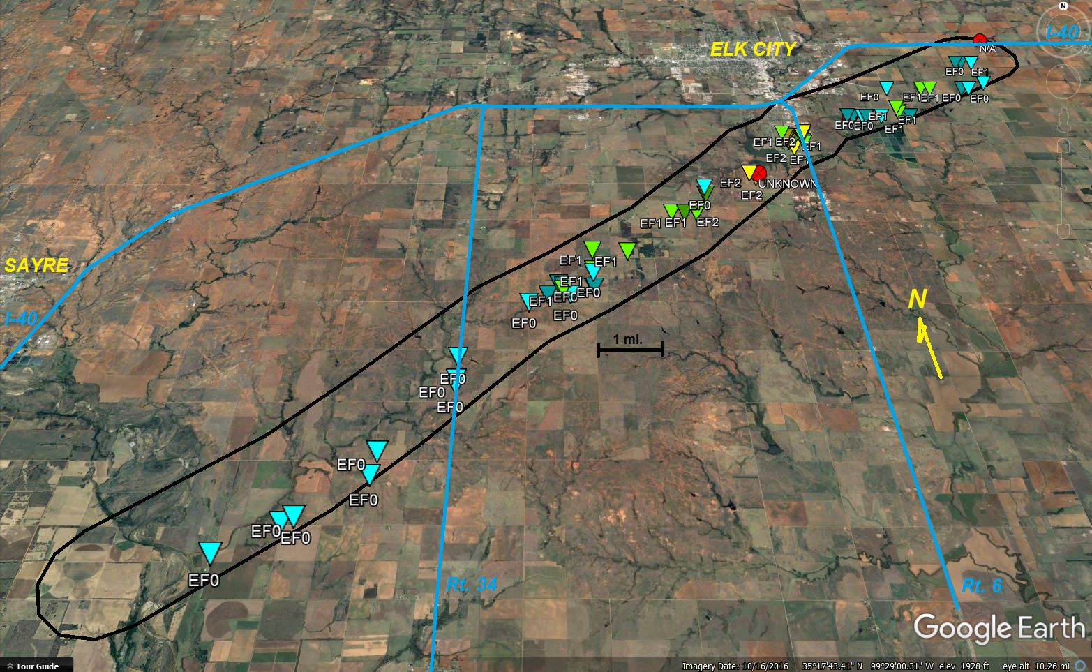
| 05/16/2017 | 1746-1818 | 18 | 1000 | EF2 | 1 | 10 | Beckham/ Washita | 3 NW Carter - S side of Elk City - 3 WSW Canute | |
|
The Elk City tornado initially developed near the North Fork of the Red River about 3 miles northwest of Carter. Damage was primarily to trees and power poles for the first few miles as it moved northeast approaching OK State Highway 34. One fatality occurred on State Highway 34 (Merritt Road) south of OK State Highway 152 when his vehicle was impacted by the tornado. According to law enforcement, the victim had been in a mobile home, then left in his vehicle to try and find more substantial shelter. He had returned to his mobile home and it's believed he was still in the vehicle when the tornado hit. Moving northeast, permanent homes and mobile homes were damaged, and damage continued to power poles and trees. About two miles southwest of Elk City Reservoir, persistent EF-2 damage occurred as the tornado continued northeast over Elk City Reservoir and through a neighborhood on south side of Elk City just west of OK State Highway 6. Numerous homes were damaged and mobile homes damaged or destroyed from southwest of Elk City Reservoir through the south side of Elk City. The tornado continued moving east- northeast out of Elk City and moved into Washita County. Damage assessments found 66 homes destroyed (62 in Elk City) and 140 homes damaged (126 in Elk City). In addition, 3 businesses were destroyed and 5 businesses were damaged by the tornado. Damage costs are a rough estimate. |
|||||||||
Records taken from the Storm Prediction Center archive data, "Storm Data", and data from the National Weather Service office in Norman. Data modified as described in NOAA Tech Memo NWS SR-209 (Speheger, D., 2001: "Corrections to the Historic Tornado Database").
Historic data, especially before 1950, are likely incomplete.

