Records. Records. Records. Records. Records. Records. Records. Records. Records. Records. Records. Records. Records. Records. Records. Records. Did we mention that we broke a few records in this past year (see the "Fast Facts" tab)? 2011 is certainly gonna be one of those weather years to remember. If you can think of a weather scenario, it probably happened over Oklahoma or western north Texas. We have seen crippling blizzards, devastating tornado outbreaks, and the king of all heat waves. Throw in a couple of strong earthquakes (although not weather related) and you have a year to remember. The promise of La Niña meant warmer temperatures and below normal precipitation, but I don't think any of us were prepared for what was in store over the upcoming 12 months.
 |
 |
A graphical review of the significant weather events for the region in 2011 is available below.

|
The year started with little fanfare. The January average temperature was a little below normal (although record high temperatures were set on the 28th and 29th), but not a lot of precipitation occurred. That is, until late on January 31st, which began our first significant winter storm of the year. Widespread snowfall totals of 4 to 8 inches occurred over central and eastern Oklahoma. Kicking it up a notch, over a foot of snow fell onto parts of Oklahoma City, and this band of 12"+ extended well into northeast Oklahoma. To make matters worse, wind gusts over 50 mph were measured at several locations, causing local white-out conditions. To read more about this event, click here. |
 |
|
About a week later, parts of Oklahoma were treated to another strong winter storm. This time northern Oklahoma won out for the most snowfall. The northern half of Oklahoma received over 4 inches of snow accumulation. A heavier band of 8 to 12 inches of snow accumulated over north-central Oklahoma. As with the previous storm, wind gusts exceeded 45 mph at times, causing local white-out conditions. This particular storm also had some unusually cold air associated with it. The low temperatures over a large portion of Oklahoma and isolated areas of north Texas fell below zero. Many areas that received the snowfall dropped to around -20 degrees, some of which were all-time record low temperatures. The coldest temperature that morning was at Nowata, OK, falling to a bone-chilling -31 degrees. These temperatures will be a stark contrast to what the region would experience during the summer. To read more about this event, click here. |
 |
March is usually the transition month between the dry months of winter to the wet months of the spring. However, the average precipitation between 2 and 3 inches was not realized. In fact, very little precipitation occurred over much of the region. This was not good news, and officially, Wilbarger and Wichita Counties in Texas, and Tillman County in Oklahoma, were the first to be categorized as being in an Extreme Drought, or D3. Not only did the area of the drought expand over the next several months, but it worsened at the same time. By the end of the month, several counties in southwest, central, and southeast Oklahoma, and western north Texas were categorized as being in a D3 drought.

April 2011 brought a mixed bag of weather events with it. Most of the region remained below normal, precipitation-wise, with above normal temperatures. However, even with warm/dry weather, a few severe weather episodes occurred, some of which were significant. The dry line began to create havoc early in the month, over northern Oklahoma on April 8th, and over southern Oklahoma on April 10th. Ponca City took the brunt of the thunderstorms on the April 8th, with widespread damage over a large portion of the city.
A few days later on April 14th, a significant tornado outbreak occurred over the eastern half of Oklahoma. At least 33 tornadoes occurred from Osage County, south to Marshall County, and east toward McCurtain County. The strongest tornado struck Tushka in Atoka county, causing EF-3 damage, resulting in 2 fatalities and numerous injuries.
The drought continued to worsen, with the western half of Oklahoma and western north Texas now in a D3 drought, and D4 drought was introduced for Tillman and Jackson Counties in Oklahoma, and Wilbarger and Wichita Counties in north Texas.

May 2011 brought its share of severe weather events to the state, including some of it in devastating fashion. Most severe events during the early portion of the month were nothing in comparison to what happened on the May 24, 2011. There was a set-up severe weather day on the May 23rd, with very large hail and 1 weak tornado coming from one of many supercell thunderstorms. What made this day "special" was the largest hailstone in Oklahoma history that fell near Gotebo, and was measured at 6 inches in diameter!

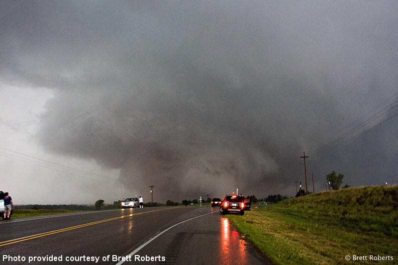
The next day, however, would be the BIG day of the 2011 Severe Weather season. A tornado outbreak occurred over the eastern two-thirds of Oklahoma. Three particular tornadoes were the headline of the event. All 3 were long-track, violent tornadoes that moved through central Oklahoma during the late afternoon/early evening hours. One of the tornadoes was rated an EF-5, the first Oklahoma EF-5 tornado since the historic tornado outbreak of May 3, 1999. The other two tornadoes were rated strong EF-4 tornadoes. The long-track tornadoes left behind a trail of destruction, debarking/uprooting trees and wiping foundations clean. A mesonet site near El Reno took an indirect hit from the EF-5 tornado, measuring a wind gust of 151 mph! Unfortunately, 11 people lost their lives as a result of the tornadoes.
A little under the radar tidbit, May 1st was actually quite chilly. The high temperature may officially go down as being in the 60s, but that was an early in the day high temperature. Temperatures quickly fell into the 40s over many areas with a cold rain falling. As it turns out, this was our last taste of cool weather, with the hottest summer on record just around the corner.
And just like that...

...the weather got hot and stayed hot for 3 months!
The D4 drought was moving northward, now covering the western tier of counties in Oklahoma, and all but Clay County in western north Texas.

Those in Norman will not forget the sudden severe thunderstorm that struck just after dinnertime on the June 14, 2011. A wet downburst occurred on the west side of town and moved east through the northern half of the city. The winds were measured at 82 mph near 12th and Boyd, and may have been stronger had the large hail not destroyed the anemometer.
The summer of 2011 is a season we would all like to forget. Parts of southwest Oklahoma and northern Texas had already had a few days with temperatures over 100 degrees, but a larger area joined the party toward the middle of the month. The hotter and drier conditions that were forecast began to unfold as planned. Hot temperatures continued through July and August, many not getting any reprieve for 2 solid months! Wichita Falls recorded temperatures at or over 100 degrees from June 22 until August 12. After a 2 day "cool down" (93 and 99 degrees) they had temperatures again over 100 degrees from August 15 through September 3. The hot temperatures were coupled with only 0.59 inches of rainfall (the majority fell in August). A comprehensive list summertime temperature facts and data can be found for Oklahoma City, and for Wichita Falls, TX.
By the end of August, the western two-thirds of Oklahoma and all of western north Texas were considered to be in an Exceptional (D4) drought. Changes were coming, in the form of some temperature relief and increased rainfall.
The day that most of us had been waiting on for a few months, the last day with temperatures exceeding 100 (at least for this year) finally came. September 13th was that day. Temperatures soared over 100 degrees over many areas, but were only in the 80s the next day (and even 60s the day after that). In total for the summer, Oklahoma City set a record of 63 days with high temperatures at or above 100 degrees. Wichita Falls also broke a record, with high temperatures reaching or exceeding 100 degrees 100 times.
Although the drought status changed little through the month, September brought some relief to the intense heat. The drought had taken its toll on the region agriculturally, with some estimates as high as $2 billion in losses. Several heat related deaths were also reported, with at least 20 people lost from heat related illnesses.
October marked the return of beneficial rainfall!!!!!!!!!!!!! Yay!!!!!!!!!!!! A couple of good soaking rainfall events occurred during the month, adding up to over 5 inches for many areas. Even parched western Oklahoma received between 3 and 5 inches of rainfall. It wasn't a drought buster, but it was a step in the right direction toward getting out of the D4 Drought mess.

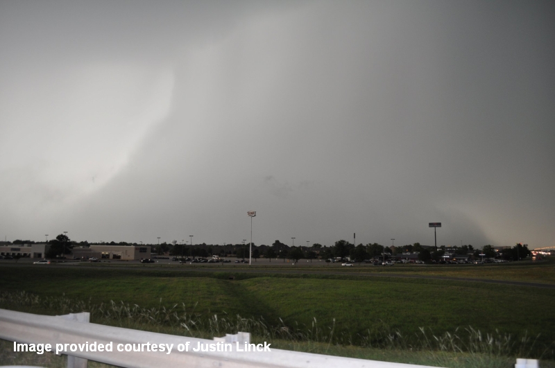
November was an interesting month for a few reasons. First, a late-season mini-tornado outbreak occurred over southwest Oklahoma on the 7th. A particularly nasty supercell thunderstorm developed and moved from northern Wilbarger County in north Texas into Tillman, Comanche, and Caddo Counties. The storm produced several tornadoes, including the first recorded November EF-4 tornado in Oklahoma near Tipton, OK. Other strong tornadoes occurred that day as they moved toward the Wichita Mountain National Wildlife Refuge, with spectacular video captured of a large tornado moving over the refuge. The supercell was eventually overtaken by a squall line that had formed to the west. Very heavy rainfall occurred as the line moved east, including a swath of 5"+ from northern Canadian into Oklahoma County.
Unrelated to the weather, several strong (for Oklahoma standards) earthquakes rattled central Oklahoma from the 5th through the 7th. The first earthquake occurred during the early morning hours of the 5th (magnitude 4.8). The second and strongest of the 3 quakes occurred later that evening (magnitude 5.7). And finally, the third earthquake struck during the early evening of the 7th (magnitude 4.8). The last earthquake actually hit during the severe weather episode written about above.
With all that had happened during the year, blizzards, tornadoes, record hail, drought, and earthquakes, it was only fitting that December was about as uneventful as it could be. One cold temperature episode occurred early in the month, with many locations not warming above freezing for over 24 hours. A big snowstorm almost moved into northwest Oklahoma on the 20th, but stayed mostly to the west. So, to sum up the month of December considering the previous 11 months, "ho-hum" comes to mind.