Headlines Issued by NWS Memphis
The NWS issues watches, warnings, advisories, and statements to highlight potential for hazardous or dangerous weather conditions. These special products, often referred to as ‘headlines’, are issued when the forecaster feels there is sufficient confidence of an event occurring. The NWS warning program uses a multi-tiered concept to increase public awareness and promote proper response to the impending hazard. Generally, the multi-tiered concept conveys certain levels of urgency as described below:
1. Outlook/Statement: An outlook or statement is used to indicate that a hazardous weather event may develop, but there is still much uncertainty. Forecaster confidence of an event occurring is generally greater than 30 percent. This stage is intended to provide those who need considerable lead-time prepare for the possible event. Examples of statements include the the Special Weather Statement and the Significant Weather Advisory product.
2. Watch: A watch is used when the risk of a dangerous weather event has increased, but its occurrence, location, and/or timing are still somewhat uncertain. Forecaster confidence at this stage is generally 50 percent or greater that a warning will be issued at a later time. This stage is intended to provide enough lead-time so those who need to set their plans in motion can do so.
3. Warning/Advisory: A warning or advisory is used when a hazardous weather event is imminent, or is already occurring. Forecaster confidence is generally greater than 80 percent. A warning is used for conditions that pose a threat to life and property. An advisory is used for less serious conditions that cause significant inconvenience and, if proper precautions are not taken, could pose a threat to life and property. Preparations should be completed or rushed to completion. Some warnings, especially the short-fuse, convective ones, will be followed by statements that contain updated information.
Jump to:
Convective
Fire Weather
Hydrology
Non-Precipitation
Tropical
Winter Weather
Other
| Non-Precipitation | |||||||
| Headline | Issuance Criteria | Typical Leadtime | VTEC Code | Product Acronym | Followup Product | Issued By | |
| Watches | Extreme Heat Watch | Conditions are favorable for heat indices to reach 110°F due to a combination of heat and humidity or air temperature greater than 105°F. | 24 to 72 hours | EH.A | NPW | Weather Message | WFO MEG |
| Extreme Cold Watch | Possibility of very cold temperatures and brisk winds causing dangerously cold wind chills. Consult link for criteria details. | 12 to 48 hours | EC.A | NPW | Weather Message | WFO MEG | |
| Freeze Watch | Minimum shelter temperatures below 32°F are possible during the growing season which poses a threat to plants and crops. | 18 to 48 hours | FZ.A | NPW | Weather Message | WFO MEG | |
| High Wind Watch | Conditions are favorable for sustained winds of at least 40 mph for one hour or longer, or wind gusts of at least 58 mph of any duration. | 18 to 48 hours | HW.A | NPW | Weather Message | WFO MEG | |
| Warnings | Dust Storm Warning | Widespread or localized blowing dust reducing visibilities to 1/4 mile or less. Sustained winds of 25 mph or greater are usually required. | 6 to 24 hours | DS.W | NPW | Weather Message | WFO MEG |
| Extreme Heat Warning | Heat index values of 110°F or air temperature greater than 105°F | 12 to 48 hours | EH.W | NPW | Weather Message | WFO MEG | |
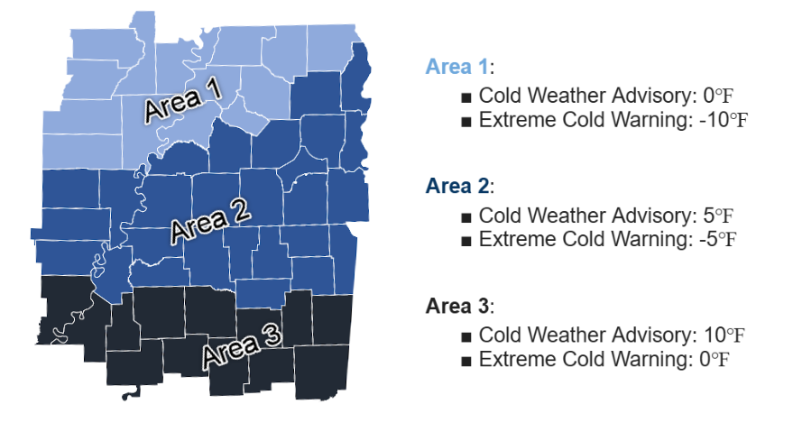
| Extreme Cold Warning | Very cold air temperatures and brisk winds causing dangerously cold wind chills are imminent or occurring. Hypothermia, frost bite, or death is likely if proper precautions are not taken. Consult link for criteria details. | 8 to 36 hours | EC.W | NPW | Weather Message | WFO MEG | |
| Freeze Warning | Minimum shelter temperatures below 32°F are expected during the growing season which poses a threat to plants and crops. | 12 to 36 hours | FZ.W | NPW | Weather Message | WFO MEG | |
| High Wind Warning | Sustained winds of at least 40 mph for one hour or longer, or wind gusts of at least 58 mph of any duration are expected. | 12 to 36 hours | HW.W | NPW | Weather Message | WFO MEG | |
| Advisories | Air Quality Alert | Atmospheric conditions are stable enough to cause air pollutants to accumulate in a given area. Criteria developed in conjunction with the local or state EPA and the product is issued at their request. | 0 to 18 hours | N/A | NPW | Weather Message | WFO MEG |
| Ashfall Advisory | Airborne ash plume resulting in ongoing deposition at the surface. Ashfall may originate directly from a volcanic eruption or from the resuspension (by wind) of a significant amount of relic ash. | 0 to 36 hours | AF.Y | NPW | Weather Message | WFO MEG | |
| Blowing Dust Advisory | Widespread or localized blowing dust reducing visibilities to one mile or less, but greater than 1/4 mile. Winds of 25 mph or greater are usually required. | 0 to 36 hours | DU.Y | NPW | Weather Message | WFO MEG | |
| Cold Weather Advisory | Cold temperatures and brisk wind causing hazardous wind chills of are imminent or occurring. Hypothermia and frost bite are possible if proper precautions are not taken. Consult link for criteria details. | 8 to 24 hours | CW.Y | NPW | Weather Message | WFO MEG | |
| Dense Fog Advisory | Widespread or localized fog reducing visibilities to 1/4 mile or less. | 6 to 36 hours | FG.Y | NPW | Weather Message | WFO MEG | |
| Dense Smoke Advisory | Widespread or localized smoke reducing visibilities to 1/4 mile or less. | 0 to 36 hours | SM.Y | NPW | Weather Message | WFO MEG | |
| Freezing Fog Advisory | Very light ice accumulation resulting from freezing fog (no visibility requirement). | 6 to 36 hours | ZF.Y | NPW | Weather Message | WFO MEG | |
| Frost Advisory | Minimum shelter temperature forecast to be 33 to 36°F during the growing season on nights with good radiational cooling making conditions condusive for frost formation (e.g., light winds, clear skies, high humidity). | 12 to 36 hours | FR.Y | NPW | Weather Message | WFO MEG | |
| Heat Advisory | The combination of heat and humidity making for heat indices between 105°F to 109°F or air temperatures 103°F to 104°F. | 12 to 36 hours | HT.Y | NPW | Weather Message | WFO MEG | |
| Wind Advisory | Sustained wind speeds of 25 to 39 mph lasting for 1 hour or longer and/or any gusts to 40 mph. | 12 to 36 hours | WI.Y | NPW | Weather Message | WFO MEG | |
| Winter Weather | |||||||
| Headline | Issuance Criteria | Typical Leadtime | VTEC Code | Product Acronym | Followup Product | Issued By | |
| Watches | Winter Storm Watch | Possibility of accumulating snow, sleet, and/or freezing rain causing significant impacts to society and commerce. | 12 to 48 hours | WS.A | WSW | Winter Weather Message | WFO MEG |
| Warnings | Blizzard Warning | Sustained winds or frequent gusts of 35 mph or higher causing falling and/or blowing snow to reduce visibilities below 1/4 mile for 3 hours or longer are imminent or occurring. | 8 to 36 hours | BZ.W | WSW | Winter Weather Message | WFO MEG |
| Ice Storm Warning | Heavy ice accumulation of 1/4 inch or greater due to freezing rain is imminent or occurring. | 8 to 36 hours | IS.W | WSW | Winter Weather Message | WFO MEG | |
| Winter Storm Warning | Heavy snow and/or sleet and ice accumulations are imminent or occurring. Society and commerce is expected to be greatly impacted. Precipitation may be accompanied by gusty wind. For a mixture of snow, sleet, or freezing rain, only two inches of snow is required. Consult this link for a map of requirements for pure snowfall. | 8 to 36 hours | WS.W | WSW | Winter Weather Message | WFO MEG | |
| Advisories | Winter Weather Advisory | Snow and/or sleet and/or ice accumulations causing an inconvenience to society and commerce are imminent or occurring. | 8 to 24 hours | WW.Y | WSW | Winter Weather Message | WFO MEG |

