National Weather Service United States Department of Commerce
News Headlines

Marine Weather for the Florida Keys


Listen to Marine Weather Information on NOAA All Hazards Weather Radio

Hourly Weather Graph for Selected Florida Keys Marine Locations

Wave Graphics From Nearshore Wave Prediction System

Florida Keys Coastal Waters Forecast

Marine Weather On Your Phone

Submit Marine Reports HERE


Send marine weather observations, reports, pictures, or questions to Marine Program Meteorologist Chris Rothwell.


LATEST MARINE WEATHER FORECASTS...


Florida Keys Marine Zones

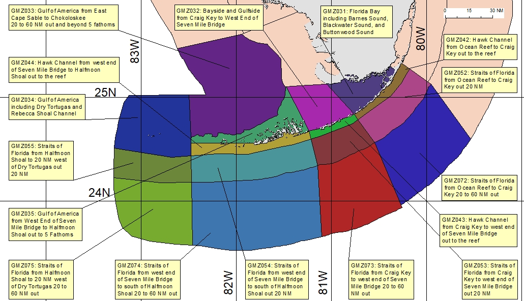
CLICK YOUR AREA OF INTEREST ON THE MAP BELOW
FOR THE LATEST MARINE WEATHER FORECAST


Florida Keys Marine Zones


GMZ042: Hawk Channel from Ocean Reef to Craig Key out to the reef GMZ052: Straits of Florida from Ocean Reef to Craig Key out 20 nm GMZ072: Straits of Florida from Ocean Reef to Craig Key 20 to 60 nm out GMZ043: Hawk Channel from Craig Key to west end of Seven Mile Bridge out to the reef GMZ053: Straits of Florida from Craig Key to west end of Seven Mile Bridge out 20 nm GMZ054: Straits of Florida from west end of Seven Mile Bridge to south of Halfmoon Shoal out 20 nm GMZ073: Straits of Florida from Craig Key to west end of Seven Mile Bridge 20 to 60 nm out GMZ074: Straits of Florida from west end of Seven Mile Bridge to south of Halfmoon Shoal 20 to 60 nm out GMZ075: Straits of Florida from Halfmoon Shoal to 20 nm west of Dry Tortugas 20 to 60 nm out GMZ055: Straits of Florida from Halfmoon Shoal to GMZ055 20 nm west of Dry Tortugas out 20 nm GMZ034: Gulf of Mexico including Dry Tortugas and Rebecca Shoal Channel GMZ044: Hawk Channel from west end of Seven Mile Bridge to Halfmoon Shoal out to the reef GMZ033: Gulf waters from East Cape Sable to Chokoloskee 20 to 60 nm out and beyond 5 fathoms GMZ032: Bayside and Gulfside from Craig Key to Halfmoon Shoal out to 5 fathoms GMZ031: Florida Bay including Blackwater and Buttonwood Sounds GMZ035: Gulf of Mexico from West End of Seven Mile Bridge to Halfmoon Shoal out to 5 Fathoms GMZ035: Gulf of Mexico from West End of Seven Mile Bridge to Halfmoon Shoal out to 5 Fathoms GMZ042: Hawk Channel from Ocean Reef to Craig Key out to the reef GMZ052: Straits of Florida from Ocean Reef to Craig Key out 20 nm GMZ072: Straits of Florida from Ocean Reef to Craig Key 20 to 60 nm out GMZ043: Hawk Channel from Craig Key to west end of Seven Mile Bridge out to the reef GMZ053: Straits of Florida from Craig Key to west end of Seven Mile Bridge out 20 nm GMZ073: Straits of Florida from Craig Key to west end of Seven Mile Bridge 20 to 60 nm out GMZ054: Straits of Florida from west end of Seven Mile Bridge to south of Halfmoon Shoal out 20 nm GMZ074: Straits of Florida from west end of Seven Mile Bridge to south of Halfmoon Shoal 20 to 60 nm out GMZ075: Straits of Florida from Halfmoon Shoal to 20 nm west of Dry Tortugas 20 to 60 nm out GMZ055: Straits of Florida from Halfmoon Shoal to GMZ055 20 nm west of Dry Tortugas out 20 nm GMZ034: Gulf of Mexico including Dry Tortugas and Rebecca Shoal Channel GMZ044: Hawk Channel from west end of Seven Mile Bridge to Halfmoon Shoal out to the reef GMZ033: Gulf waters from East Cape Sable to Chokoloskee 20 to 60 nm out and beyond 5 fathoms GMZ032: Bayside and Gulfside from Craig Key to Halfmoon Shoal out to 5 fathoms GMZ031: Florida Bay including Blackwater and Buttonwood Sounds


Marine Observations

Marine Weather Portal

Florida Keys Observations
 

Pulley Ridge (42097)

Pulaski Shoal Light (PLSF1)

Sand Key (SANF1)

Sombrero Key (SMKF1)

Long Key (LONF1)

Molasses Reef (MLRF1)

Fowey Rocks (FWYF1)

Plain Language Ship Report

Other Marine Reports

National Data Buoy Center

South Florida Buoy Location Map

Nowcoast  


Sea Surface Temperatures

NOAA/National Ocean Service

NASA Short-Term Prediction Research and Transition Center (SPoRT)

NOAA/NWS Marine Sites

NOAA Telephone Recordings

National Marine Forecasts

Voluntary Observing Ship Program

Latest Mariner's Weather Log (May 2019)

National Ocean Service - NOS

Florida Keys Marine Sanctuary

Harmful Algal Bloom Bulletins

NOAA Teacher at Sea brochure

Marine Weather - Caribbean and Tropical Atlantic
 

Weather and Ocean Maps
Surface Analysis - Florida

Tropical Atlantic Surface Analysis

Surface Map Marine Briefing

Gulf Stream Analysis

Real-Time Ocean Forecast System

NOAA WAVEWATCH III Model


Florida Keys Area Forecast Discussion


Marine Weather Warning and Forecast Messages
1 Special Marine Warning
1 Costal Hazard Message
2 Marine Weather Statement
2 Marine Weather Message

2 Short Term Forecast
2 Coastal Waters Forecast for the Florida Keys


Graphical Products
1 Gulf Stream Graphic
1 Daily Forecasts
1 Weekly Forecasts


Offshore Waters Forecasts
2 Gulf of Mexico, Caribbean, and western North Atlantic


Marine Reporting
2 Join our Marine Weather Spotter Network


NOTICE - Check time and date of forecasts. Linked data may not represent the latest forecast. The Internet is not part of the National Weather Service's operational data stream and should never be relied upon as a means to obtain the latest forecast and warning data. Become familar with and use other means such as NOAA Weather Radio to obtain the latest forecasts and warnings. Please read our DISCLAIMER


Florida Keys Tides

Tide Predictions

Current Predictions

Key West Harbor

Vaca Key  

Coastal Flooding

Boating Safety
Lightning and Boats

USCG Office of Boating Safety

National Safe Boating Council

FWC Boating Safety
 

Marine Weather References
Beaufort Wind Scale

VHF Marine Radio Channels

General Marine Definitions

Significant Wave Height or Seas

Map of Florida Keys National Marine Sanctuary

Mariner's Guide to Hurricanes (1.23MB PDF)

Florida Keys Cloud Chart
 

Coral Reef Info
NOAA's Coral Reef Conservation

Reef Relief (located in Key West)

Reef Environmental Education Foundation
 

Florida Keys Marine Sites
Mote Marine Tropical Research Laboratory