A cold front will cross the Great Lakes and Northeast U.S. through today with gusty winds and areas of rain showers. A strong atmospheric river is then expected to move into the Northwest by midweek bringing a threat for moderate to heavy rainfall and flooding, gusty winds, and mountain snows for parts of Washington, Oregon, northern California, and the Sierra Nevada. Read More >
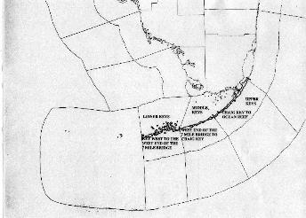
Each National Weather Service office across the U.S. issues forecasts and warnings for and provides weather services for a particular area of responsibility. Since these areas are quite large, they are broken down into "zones" and this group of zones is often referred to as the office's County Warning Area (CWA). Over land, a zone is normally a county and over water, zones are normally divided into areas of near shore waters, out to 20 nautical miles offshore, and outer waters, 20 to 60 miles offshore. These marine zones are bound by well known (as best known as possible) geographic locations over land. Describing the location of these zones verbally, such as over NOAA Weather Radio, can be difficult. Therefore, a map of the marine and land zones which the NWS office in Key West is responsible for is presented here. Hopefully, this will help customers understand where these different zones are located.
WFO Key West is responsible for 10 marine zones which cover parts of the southeastern Gulf of America, Gulf waters north of the Lower Keys and Florida Bay, waters between Key West and the Dry Tortugas and the Florida Straits. The Coastal Waters Forecast and any necessary warnings and statements are issued for these areas by WFO Key West. Usually, these zones are grouped together in a normal pattern as the weather conditions are often similar across these grouped zones.
The link below shows a map of these marine zones with the appropriate names. The northern and western most zone extends from East Cape Sable to Chokoloskee and from 20 to 60 miles offshore of Mainland Monroe County. The near shore zone from 0-20 miles offshore of Mainland Monroe County is under WFO Miami's area of responsibility. Two other zones north of the Keys are the Gulf waters 20 miles north of the Lower Keys (Key West to west end of 7 mile bridge, MM 40) and the Florida Bay. The NWS has defined the Florida Bay to be bound on the west side from East Cape Sable to the west end of the 7 mile bridge and the rest is bound by land.
The largest marine zone extends from Key West to 20 miles west of the Dry Tortugas, 20 miles north and 60 miles south. So, it includes Gulf and Atlantic waters. The remaining 6 zones are south (Atlantic side) of the Keys. Three near shore zones are bound by locations defining the lower, middle and upper Keys (see map of land zones). The outer waters, 20-60 miles offshore are also bound by locations defining the lower, middle and upper Keys. The zones south of the Keys include the Florida Straits.
Map of marine zones - click for larger image

WFO Key West has a unique area of responsibility for land zones. It is only responsible for the Florida Keys, extending from Key West to Ocean Reef (in upper Key Largo). Mainland Monroe County is under WFO Miami's area of responsibility. Most NWS offices have several counties in their CWA. Since WFO Key West has such a large marine area of responsibility, it is not practical for the office to have several land counties. The overall square mileage of the CWA for WFO Key West is comparable to other NWS offices.
The Florida Keys are broken into 3 zones for forecasting and warning by WFO Key West. The lower Keys extend from Key West to the West end of the 7 mile bridge, which is near mile marker 40 along U.S. 1. The middle Keys extend from the west end of the 7 mile bridge to Craig Key, which begins near mile marker 72. Finally, the upper Keys extend from Craig Key to Ocean Reef, which is about 15 miles northeast of Key Largo. The upper Keys zone includes a small portion of the 18 mile stretch, approximately 4 miles of the southern end and the southern 5 miles of the Card Sound Road, which goes into upper Key Largo.
Map of land zones - Click for larger image
