Wichita, Kansas
Weather Forecast Office
Radar Assistance Web Site
Hail Forecasting
| Element | Useage |
| Environment |
SPC -10C to -30C CAPE |
| Hail Lapse Rate in AWIPS (0C to -20C) of -6.5C or stronger | |
| Radar | Storm Top Divergence: Earliest Signal - Best Correlation |
| 50dbz > -20C Height: Hail Probable | |
| 50dbz > Donavon 1" Hail Height: Severe Hail Likely | |
| Three Body Scatter Spike (TBSS): Severe Hail | |
| 50 dbz > 30kft: Significant Severe Hail Probable | |
| 60dbz > -20C Height: Significant Severe Hail Probable | |
| Melting | Keep in mind that if the storm lacks tilt, the hail will fall through the updraft, causing significant melting to occur. So, mid-level shear (pre-storm)/user identified meso/tilted updraft (storm) = favorable significant hail |
 |
 |
 |
 |
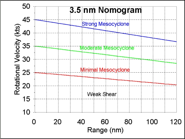
Meso Nomograms
 |
 |
 |
Radar VCP and Scan Strategies
 |
 |
 |
Hazards
Briefing pages
Local weather story
Submit a storm report
Storm Prediction Center
Enhanced Hazardous Weather Outlook
Current Conditions
Local Radar
National Radar
Satellite
Hourly weather(text)
Precip Analysis
Snowfall analysis
This day in weather history
7 Day Lightning Archive
Forecasts
Forecast Discussion
Weather Story
Fire Weather
Activity Planner
Aviation Weather
Soaring Forecast
Hurricane Center
Graphical Forecasts
Regional Weather Summary
Probabilistic Snow
Probabilistic QPF
Wet Bulb Globe temp
Climate
Local Climate Page
Daily/Monthly data(F6)
Daily Records
Climate Normals
Local drought page
Latest Climate Report(ICT)
Latest Climate Report(SLN)
Latest Climate Report(CNU)
CoCoRaHS
7 Day Lightning Archive
US Dept of Commerce
National Oceanic and Atmospheric Administration
National Weather Service
Wichita, Kansas
2142 S. Tyler Road
Wichita, KS 67209-3016
316-942-3102
Comments? Questions? Please Contact Us.

