Overview
|
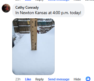
An extremely cold Arctic airmass surged south across the Plains on Tuesday February 18th. At the same time a weak upper disturbance quickly slid across the area, bringing moderate to heavy snowfall to much of the region. Many locations picked-up between 5 and 9 inches of snowfall in a short amount of time along with strong northeast winds that caused blowing and drifting of snow. Wind chills starting Tuesday afternoon were in the -15 to -20 range with these same values occurring on Wednesday and Thursday morning. Around 19 temperature records were broken during this three day stretch. |
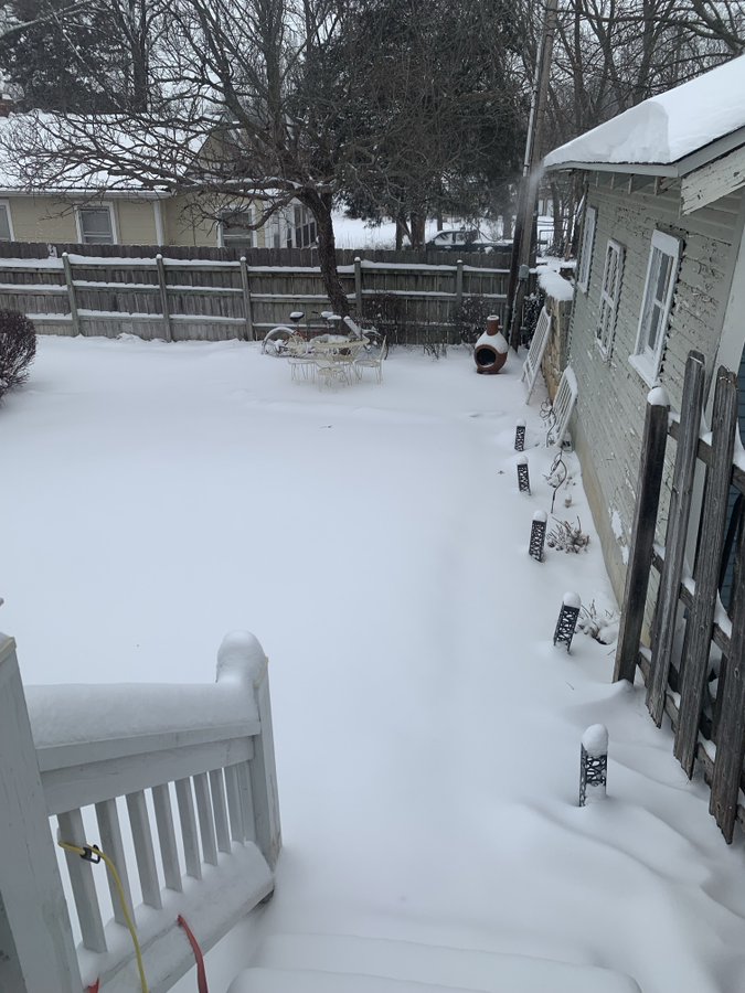
Picture by Chance Hayes |
Photos & Video
 |
 |
 |
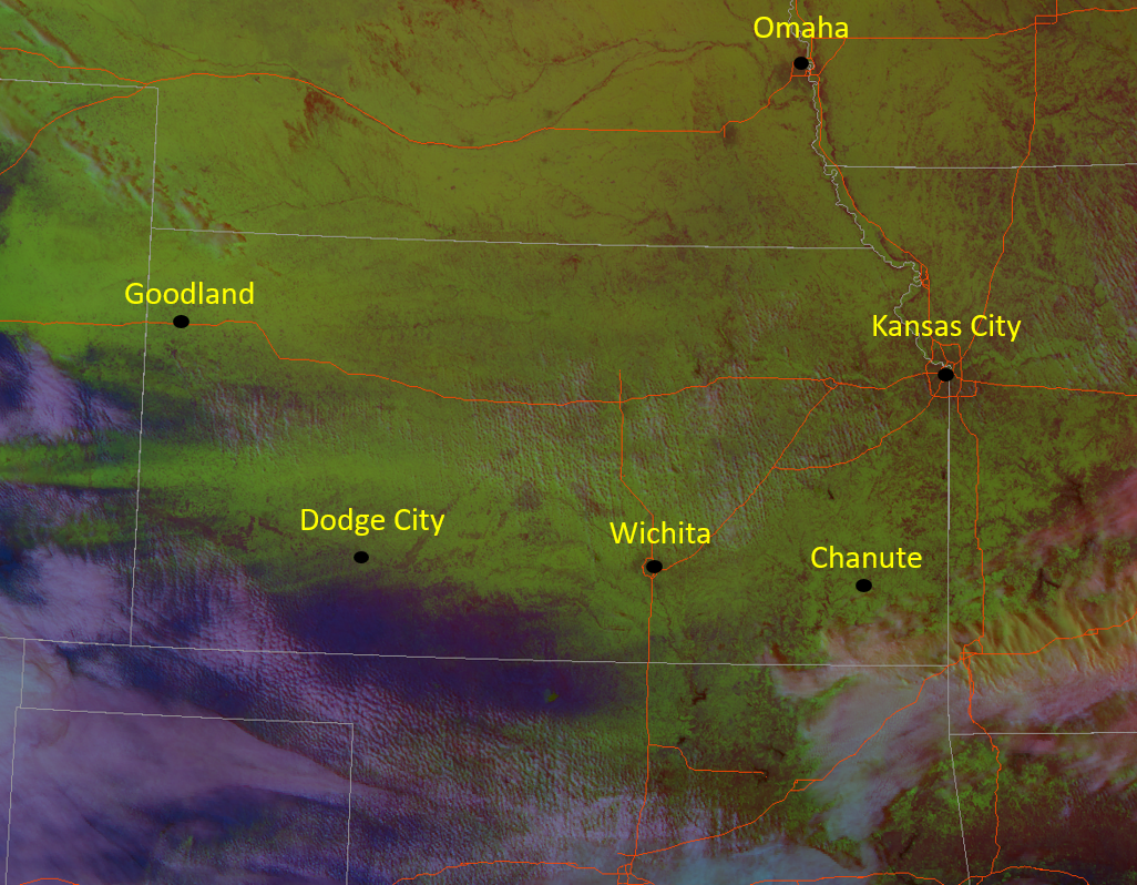
| Radar animation on Feb 18th | Satellite imagery showing how widespread snow coverage(green) was across the Plains. | Time lapse from NWS Wichita |
 |
 |
|
|
|
|
Storm Reports
PRELIMINARY LOCAL STORM REPORT...SUMMARY
NATIONAL WEATHER SERVICE WICHITA KS
1029 AM CST WED FEB 19 2025
..TIME... ...EVENT... ...CITY LOCATION... ...LAT.LON...
..DATE... ....MAG.... ..COUNTY LOCATION..ST.. ...SOURCE....
..REMARKS..
0848 AM SNOW STERLING 38.21N 98.21W
02/19/2025 M10.5 INCH RICE KS CO-OP OBSERVER
2 DAY STORM TOTAL.
0846 AM SNOW 3 E MCPHERSON 38.38N 97.61W
02/19/2025 M8.0 INCH MCPHERSON KS CO-OP OBSERVER
2 DAY STORM TOTAL.
0844 AM SNOW 1 WSW IOLA 37.92N 95.41W
02/19/2025 M6.0 INCH ALLEN KS CO-OP OBSERVER
2 DAY STORM TOTAL.
0842 AM SNOW 1 W HUMBOLDT 37.81N 95.45W
02/19/2025 M9.0 INCH ALLEN KS CO-OP OBSERVER
2 DAY STORM TOTAL.
0816 AM SNOW BARTLETT 37.05N 95.21W
02/19/2025 M7.5 INCH LABETTE KS CO-OP OBSERVER
0700 AM SNOW 2 SSE ARKANSAS CITY 37.04N 97.02W
02/19/2025 M3.0 INCH COWLEY KS COCORAHS
STORM-TOTAL.
0700 AM SNOW 1 ESE EL DORADO 37.82N 96.83W
02/19/2025 M5.8 INCH BUTLER KS CO-OP OBSERVER
STORM-TOTAL.
0700 AM SNOW 1 W GREAT BEND 38.36N 98.83W
02/19/2025 M6.0 INCH BARTON KS CO-OP OBSERVER
STORM-TOTAL.
0700 AM SNOW 1 WNW ROSALIA 37.82N 96.64W
02/19/2025 M6.7 INCH BUTLER KS CO-OP OBSERVER
STORM-TOTAL.
0630 AM SNOW AUGUSTA 37.70N 96.97W
02/19/2025 M4.5 INCH BUTLER KS CO-OP OBSERVER
STORM-TOTAL.
0611 AM SNOW 7 NNE ALTOONA 37.62N 95.60W
02/19/2025 M4.1 INCH WILSON KS COCORAHS
STORM-TOTAL.
0605 AM SNOW ARKANSAS CITY 37.06N 97.04W
02/19/2025 M3.1 INCH COWLEY KS CO-OP OBSERVER
STORM-TOTAL.
0600 AM SNOW CAMBRIDGE 37.31N 96.66W
02/19/2025 M3.0 INCH COWLEY KS CO-OP OBSERVER
STORM-TOTAL.
0600 AM SNOW 2 N COFFEYVILLE 37.07N 95.63W
02/19/2025 M5.0 INCH MONTGOMERY KS CO-OP OBSERVER
STORM-TOTAL.
0600 AM SNOW ERIE 37.57N 95.25W
02/19/2025 M4.0 INCH NEOSHO KS COCORAHS
STORM-TOTAL.
0600 AM SNOW 3 WNW GOESSEL 38.27N 97.39W
02/19/2025 M5.0 INCH MCPHERSON KS CO-OP OBSERVER
STORM-TOTAL.
0600 AM SNOW 4 WNW LITTLE RIVER 38.42N 98.09W
02/19/2025 M7.7 INCH RICE KS COCORAHS
STORM-TOTAL.
0541 AM SNOW 3 WNW ASSARIA 38.70N 97.65W
02/19/2025 M3.9 INCH SALINE KS COCORAHS
STORM-TOTAL.
0500 AM SNOW 7 WNW MARQUETTE 38.60N 97.95W
02/19/2025 M3.2 INCH ELLSWORTH KS COCORAHS
STORM-TOTAL.
1129 PM SNOW 1 W WICHITA EISENHOWER 37.65N 97.44W
02/18/2025 M5.4 INCH SEDGWICK KS OFFICIAL NWS OBS
STORM TOTAL MEASURED AT THE NATIONAL WEATHER
SERVICE. LIQUID EQUIVALENT WAS 0.36 INCHES.
1039 PM SNOW NEWTON 38.05N 97.34W
02/18/2025 M5.7 INCH HARVEY KS PUBLIC
0837 PM SNOW OSWEGO 37.17N 95.11W
02/18/2025 M5.5 INCH LABETTE KS LAW ENFORCEMENT
0751 PM SNOW 1 S HAVEN 37.89N 97.78W
02/18/2025 M7.5 INCH RENO KS PUBLIC
0730 PM SNOW HALSTEAD 38.00N 97.51W
02/18/2025 M6.0 INCH HARVEY KS PUBLIC
0628 PM SNOW 2 E WICHITA 37.75N 97.30W
02/18/2025 E7.0 INCH SEDGWICK KS BROADCAST MEDIA
0601 PM SNOW EL DORADO 37.82N 96.86W
02/18/2025 M5.0 INCH BUTLER KS PUBLIC
ALSO MEASURED AN 8 FEET TALL DRIFT.
0600 PM SNOW DOUGLASS 37.52N 97.01W
02/18/2025 M7.5 INCH BUTLER KS PUBLIC
0559 PM SNOW VALLEY CENTER 37.84N 97.37W
02/18/2025 M7.5 INCH SEDGWICK KS PUBLIC
0550 PM SNOW GREAT BEND 38.36N 98.81W
02/18/2025 M8.8 INCH BARTON KS PUBLIC
0533 PM SNOW 1 WSW WHITEWATER 37.96N 97.17W
02/18/2025 M6.1 INCH HARVEY KS NWS EMPLOYEE
UPDATED TOTAL SNOWFALL FOR EVENT.
0532 PM SNOW PARK CITY 37.80N 97.32W
02/18/2025 M5.8 INCH SEDGWICK KS EMERGENCY MNGR
0530 PM SNOW 1 SSW EL DORADO 37.80N 96.86W
02/18/2025 M6.0 INCH BUTLER KS PUBLIC
0510 PM SNOW BEL AIRE 37.76N 97.27W
02/18/2025 M6.4 INCH SEDGWICK KS PUBLIC
0500 PM SNOW RUSSELL 38.89N 98.85W
02/18/2025 M4.5 INCH RUSSELL KS FIRE DEPT/RESCUE
0445 PM SNOW INDEPENDENCE 37.23N 95.71W
02/18/2025 M6.5 INCH MONTGOMERY KS PUBLIC
0324 PM SNOW HUTCHINSON 38.06N 97.91W
02/18/2025 M5.2 INCH RENO KS BROADCAST MEDIA
0300 PM SNOW MOUNT HOPE 37.87N 97.66W
02/18/2025 M7.0 INCH SEDGWICK KS CO-OP OBSERVER
UPDATE FROM PREVIOUS REPORT ISSUED AROUND 1
PM. NEW TOTAL SNOW REFLECTS AROUND 1
ADDITIONAL INCH IN THE PAST 2 HOURS.
0255 PM SNOW MAIZE 37.77N 97.46W
02/18/2025 M5.5 INCH SEDGWICK KS BROADCAST MEDIA
0250 PM SNOW MOUNDRIDGE 38.20N 97.52W
02/18/2025 M5.0 INCH MCPHERSON KS PUBLIC
0222 PM SNOW SALINA 38.82N 97.62W
02/18/2025 M4.0 INCH SALINE KS PUBLIC
0220 PM SNOW KINGMAN 37.65N 98.11W
02/18/2025 M5.0 INCH KINGMAN KS PUBLIC
.
0131 PM SNOW HUTCHINSON 38.07N 97.91W
02/18/2025 M7.0 INCH RENO KS PUBLIC
MANY REPORTS OF 5 TO 7 INCHES ACROSS THE
CITY OF HUTCHINSON.
1239 PM SNOW GALESBURG 37.47N 95.36W
02/18/2025 M3.0 INCH NEOSHO KS EMERGENCY MNGR
1232 PM SNOW SAINT PAUL 37.52N 95.17W
02/18/2025 E2.5 INCH NEOSHO KS FIRE DEPT/RESCUE
STORM TOTAL SNOWFALL SO FAR. RELAYED VIA
EMERGENCY MANAGER.
1200 PM SNOW 1 N MCPHERSON 38.39N 97.66W
02/18/2025 M3.7 INCH MCPHERSON KS NWS EMPLOYEE
&&
THE TOTALS BELOW ARE SEPARATED INTO SNOW...AND ICE AND SLEET
CATEGORIES...THEN BY AMOUNT...AND ARE NOT NECESSARILY THE
FINAL AMOUNT FOR EACH LOCATION.
SNOW REPORTS LISTED BY AMOUNT
INCHES LOCATION ST COUNTY TIME
------ ----------------------- -- -------------- -------
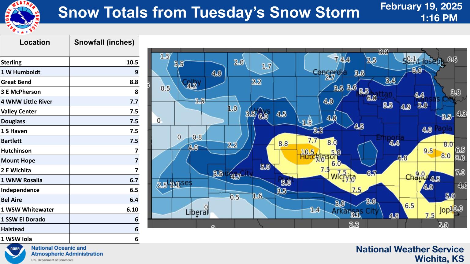
10.50 STERLING KS RICE 0848 AM
2 DAY STORM TOTAL.
9.00 1 W HUMBOLDT KS ALLEN 0842 AM
2 DAY STORM TOTAL.
8.80 GREAT BEND KS BARTON 0550 PM
8.00 3 E MCPHERSON KS MCPHERSON 0846 AM
2 DAY STORM TOTAL.
7.70 4 WNW LITTLE RIVER KS RICE 0600 AM
STORM-TOTAL.
7.50 VALLEY CENTER KS SEDGWICK 0559 PM
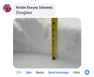
7.50 DOUGLASS KS BUTLER 0600 PM
7.50 1 S HAVEN KS RENO 0751 PM
7.50 BARTLETT KS LABETTE 0816 AM
7.00 HUTCHINSON KS RENO 0131 PM
MANY REPORTS OF 5 TO 7 INCHES ACROSS THE CITY
OF HUTCHINSON.
7.00 MOUNT HOPE KS SEDGWICK 0300 PM
UPDATE FROM PREVIOUS REPORT ISSUED AROUND 1
PM. NEW TOTAL SNOW REFLECTS AROUND 1
ADDITIONAL INCH IN THE PAST 2 HOURS.
7.00 2 E WICHITA KS SEDGWICK 0628 PM
6.70 1 WNW ROSALIA KS BUTLER 0700 AM
STORM-TOTAL.
6.50 INDEPENDENCE KS MONTGOMERY 0445 PM
6.40 BEL AIRE KS SEDGWICK 0510 PM
6.10 1 WSW WHITEWATER KS HARVEY 0533 PM
UPDATED TOTAL SNOWFALL FOR EVENT.
6.00 1 SSW EL DORADO KS BUTLER 0530 PM
6.00 HALSTEAD KS HARVEY 0730 PM
6.00 1 W GREAT BEND KS BARTON 0700 AM
STORM-TOTAL.
6.00 1 WSW IOLA KS ALLEN 0844 AM
2 DAY STORM TOTAL.
5.80 PARK CITY KS SEDGWICK 0532 PM
5.80 1 ESE EL DORADO KS BUTLER 0700 AM
STORM-TOTAL.
5.70 NEWTON KS HARVEY 1039 PM
5.50 MAIZE KS SEDGWICK 0255 PM
5.50 OSWEGO KS LABETTE 0837 PM
5.40 1 W WICHITA EISENHOWER KS SEDGWICK 1129 PM
STORM TOTAL MEASURED AT THE NATIONAL WEATHER
SERVICE. LIQUID EQUIVALENT WAS 0.36 INCHES.
5.20 HUTCHINSON KS RENO 0324 PM
5.00 KINGMAN KS KINGMAN 0220 PM
.
5.00 MOUNDRIDGE KS MCPHERSON 0250 PM
5.00 EL DORADO KS BUTLER 0601 PM
ALSO MEASURED AN 8 FEET TALL DRIFT.
5.00 3 WNW GOESSEL KS MCPHERSON 0600 AM
STORM-TOTAL.
5.00 2 N COFFEYVILLE KS MONTGOMERY 0600 AM
STORM-TOTAL.
4.50 RUSSELL KS RUSSELL 0500 PM
4.50 AUGUSTA KS BUTLER 0630 AM
STORM-TOTAL.
4.10 7 NNE ALTOONA KS WILSON 0611 AM
STORM-TOTAL.
4.00 SALINA KS SALINE 0222 PM
4.00 ERIE KS NEOSHO 0600 AM
STORM-TOTAL.
3.90 3 WNW ASSARIA KS SALINE 0541 AM
STORM-TOTAL.
3.70 1 N MCPHERSON KS MCPHERSON 1200 PM
3.20 7 WNW MARQUETTE KS ELLSWORTH 0500 AM
STORM-TOTAL.
3.10 ARKANSAS CITY KS COWLEY 0605 AM
STORM-TOTAL.
3.00 GALESBURG KS NEOSHO 1239 PM
3.00 CAMBRIDGE KS COWLEY 0600 AM
STORM-TOTAL.
3.00 2 SSE ARKANSAS CITY KS COWLEY 0700 AM
STORM-TOTAL.
2.50 SAINT PAUL KS NEOSHO 1232 PM
STORM TOTAL SNOWFALL SO FAR. RELAYED VIA
EMERGENCY MANAGER.
Extreme Cold
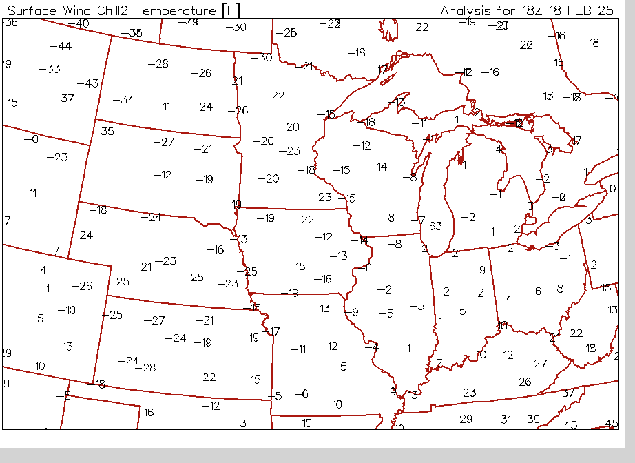
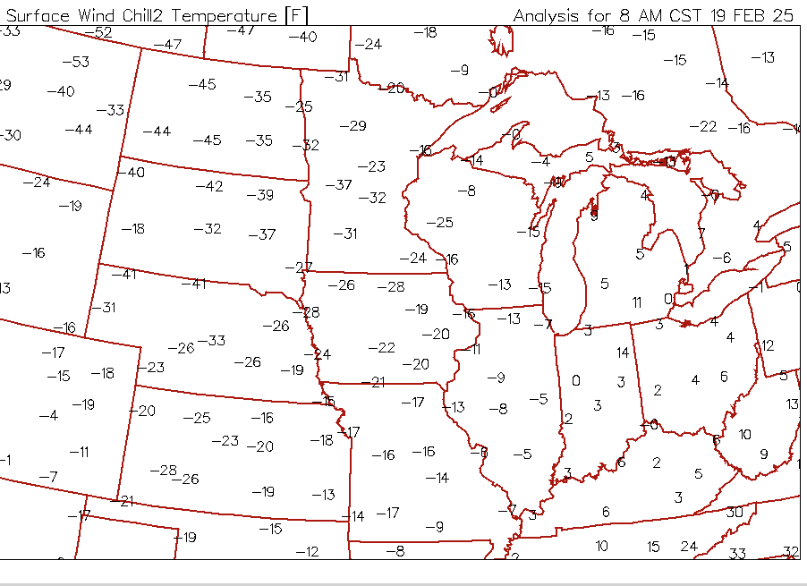
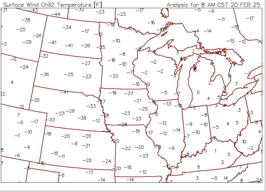
Below is information on the Arctic airmass that overspread the region on February 18th through February 20th.
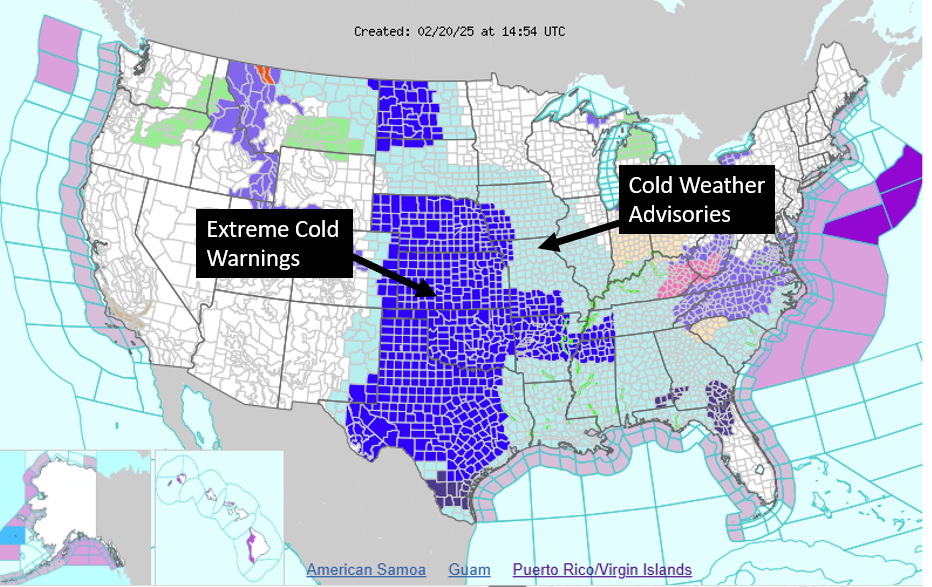
 |
Map showing how expansive the cold weather watches and warnings were |
|
Wind chills early Tuesday afternoon(2/18) |
Wind chills Wednesday morning(2/19) |
Wind chills Thursday morning (2/20) |
||
 |
||||
Records broken:
Tuesday February 18th:
* Wichita - Record cold high temperature of 13 degrees. Previous record 17 degrees set back in 1938.
* Russell - Record cold high temperature of 0 degrees. Previous record was 16 degree set back in 2006.
* Salina - Record cold high temperature of 6 degrees. Previous record was 17 degrees set back in 1938
* Chanute - Record cold high temperature of 19 degrees. Previous record was 20 degrees set back in 2006.
Wednesday February 19th:
* Wichita - Record low temperature of 0 degree. Previous record was 2 degrees set back in 1975.
Record cold high temperature of 8. Previous record was 20 degrees set back in 1889.
* Russell - Record low temperature of -9. Previous record was 3 degrees set back in 1978.
Record cold high temperature of 5. Previous record was 16 degrees set back in 1955.
* Salina - Record low temperature of -7. Previous record was -3 degrees set back in 1978.
Record cold high temperature of 8.Previous record was 17 degrees set back in 1929.
* Chanute - Record cold high temperature of 12 degrees. Previous record was 22 degree set back in 2006.
Thursday February 20th:
* Wichita - Record low temperature of -8. Previous record was 3 degrees set back in 1918.
Record cool high temperature of 13. Previous record was 15 degrees set back in 1918
* Salina - Record low temperature of -10. Previous record was 0 degrees set back in 1918.
Record cool high temperature of 12. Previous record was 13 degrees set back in 1918
* Russell - Record low temperature of -14. Previous record was 6 degrees set back in 1955.
Record cool high temperature of 12. Previous record was 21 degrees set back in 1966
* Chanute - Record low temperature of -9. Previous record was 4 degree set back in 1918.
Record cool high temperature of 15. Previous record was 21 degrees set back in 1918
 |
Media use of NWS Web News Stories is encouraged! Please acknowledge the NWS as the source of any news information accessed from this site. |
|