Overview
|
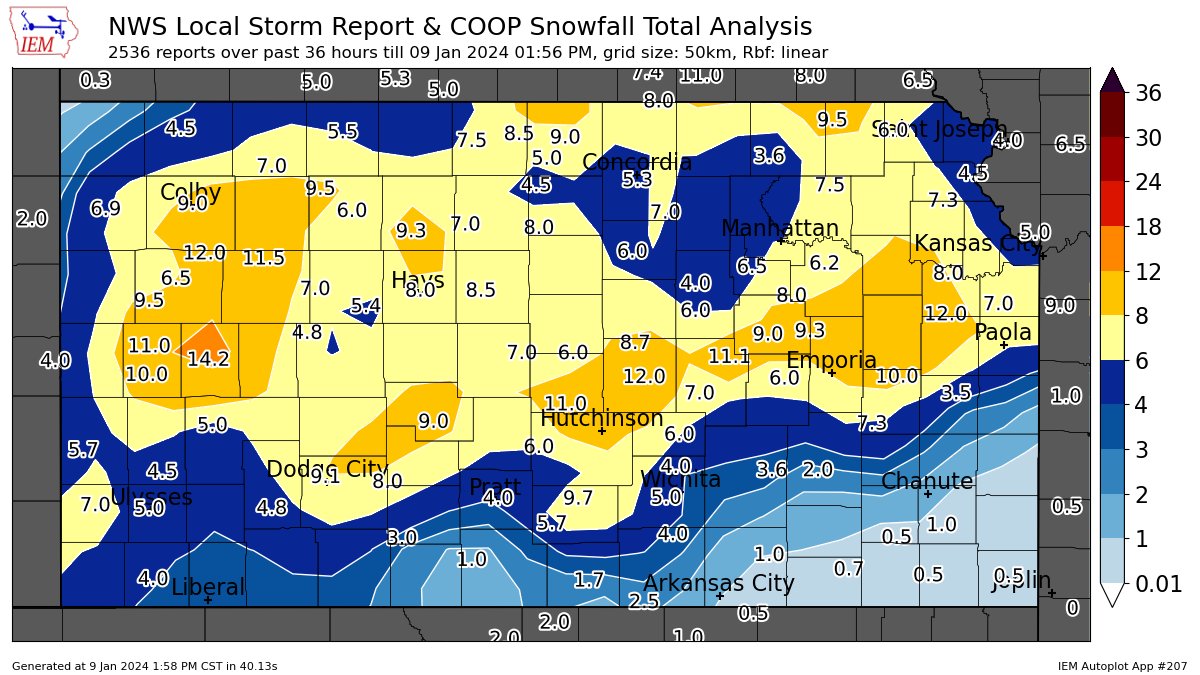
One of the most impactful winter storms to affect Kansas in a very long time struck on January 8th and 9th when an intense low pressure system tracked east across the region. Blizzard conditions impacted much of western and central Kansas during the day on Monday January 8th with 60 mph winds and near zero visibility. As the low pressure system tracked east, high winds and snow impacted south central and eastern Kansas during the overnight hours. Almost all roads were closed across the western half of Kansas by Monday evening, including I-70 west of Salina to the Colorado border. Kansas Highway Patrol responded to nearly 100 calls from motorists during the storm. Strong winds and heavy snow also caused numerous power outages across the region. With the exception of far southeast Kansas, most schools across Kansas cancelled classes, many for a few days. The highest snowfall amounts were generally in the 8 to 12 inch range with these higher amounts generally along and south of I-70 and north of Highway 400. |
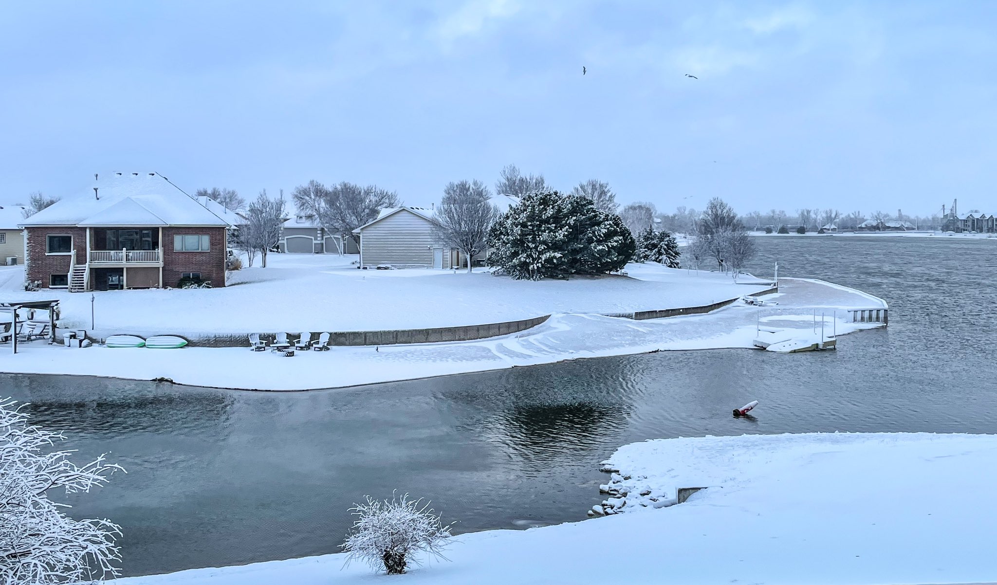 Picture by Kevin Darmofal |
Photos & Video
|
Map of snow amounts |
Water vapor satellite imagery of the storm system |
 |
 |
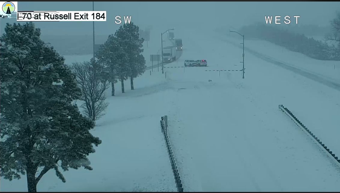 |
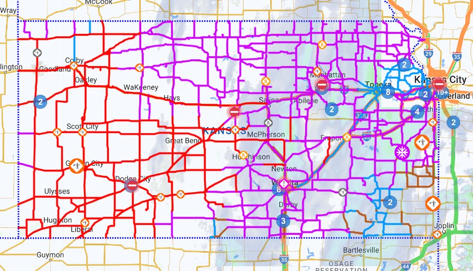
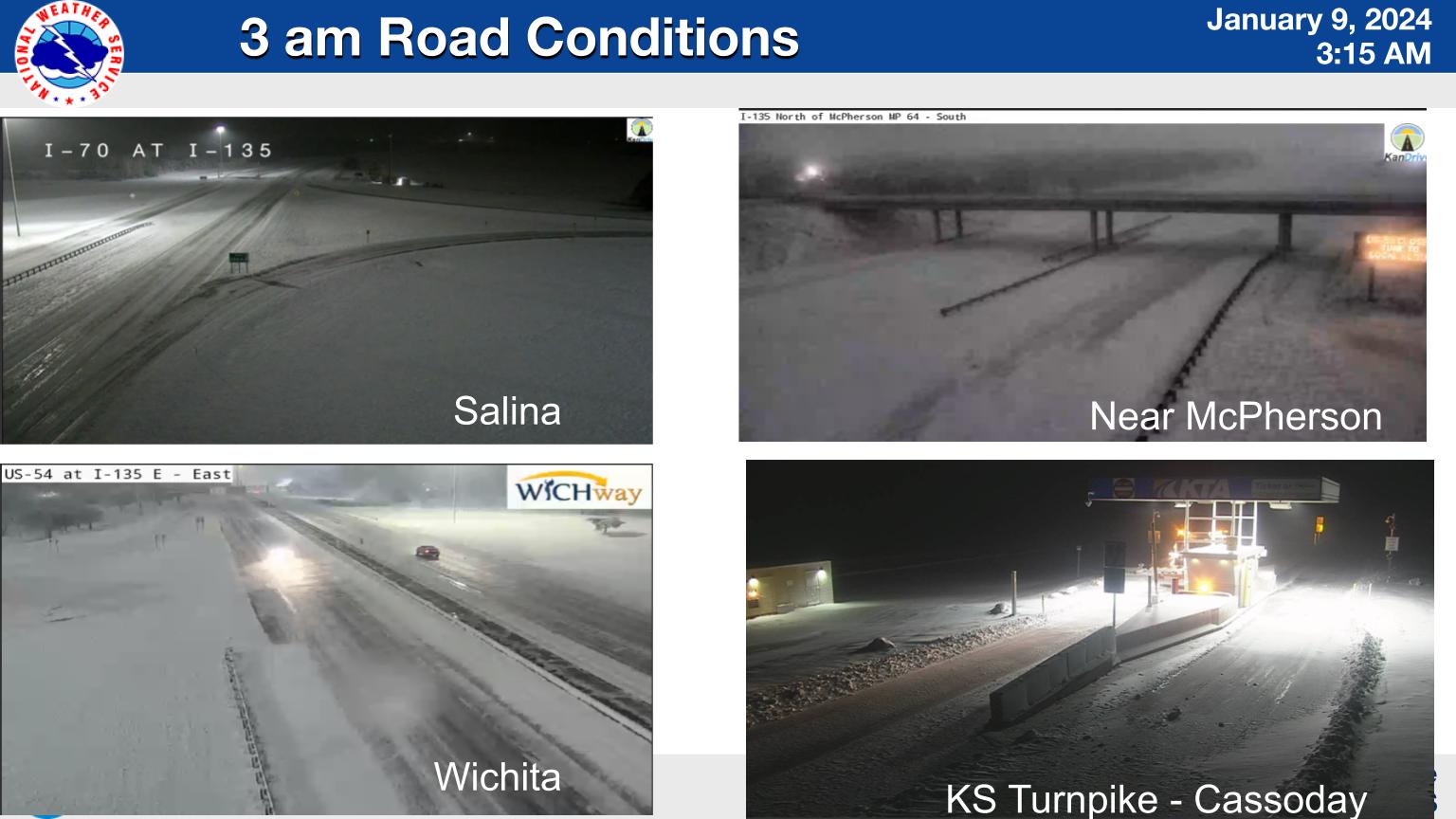
| Map showing the number of road closures (red) | Look at road conditions around 3 am on Jan 9th | I-70 near Russell on the evening of Jan 8th |
|
|
|
|
|
|
|
|
|
|
|
|
Storm Reports
PRELIMINARY LOCAL STORM REPORT...SUMMARY
NATIONAL WEATHER SERVICE WICHITA KS
737 PM CST TUE JAN 9 2024
..TIME... ...EVENT... ...CITY LOCATION... ...LAT.LON...
..DATE... ....MAG.... ..COUNTY LOCATION..ST.. ...SOURCE....
..REMARKS..
0752 PM SNOW SALINA 38.82N 97.62W
01/08/2024 M4.0 INCH SALINE KS PUBLIC
0822 PM SNOW CLAFLIN 38.52N 98.54W
01/08/2024 M7.0 INCH BARTON KS PUBLIC
0845 PM SNOW KINGMAN 37.65N 98.11W
01/08/2024 M2.0 INCH KINGMAN KS CO-OP OBSERVER
SNOW STARTED AT 6:15PM. SNOW AMOUNT THUS
FAR.
0850 PM SNOW MCPHERSON 38.37N 97.66W
01/08/2024 M3.0 INCH MCPHERSON KS BROADCAST MEDIA
KSKU RADIO REPORTING 3 INCHES OF SNOW THUS
FAR ON THE EASTERN EDGE OF DOWNTOWN.
0916 PM SNOW MARION 38.35N 97.02W
01/08/2024 M1.5 INCH MARION KS 911 CALL CENTER
CURRENT SNOW AMOUNT THUS FAR.
1000 PM SNOW MCPHERSON 38.37N 97.66W
01/08/2024 M5.5 INCH MCPHERSON KS NWS EMPLOYEE
OFF DUTY NWS EMPLOYEE REPORETED 5.5 INCHES.
1001 PM SNOW 3 N HUTCHINSON 38.11N 97.91W
01/08/2024 M6.0 INCH RENO KS PUBLIC
1019 PM SNOW SALINA 38.82N 97.62W
01/08/2024 M6.8 INCH SALINE KS PUBLIC
1042 PM SNOW KINGMAN 37.65N 98.11W
01/08/2024 M4.0 INCH KINGMAN KS CO-OP OBSERVER
1045 PM SNOW 1 NW HUTCHINSON 38.08N 97.93W
01/08/2024 M7.3 INCH RENO KS PUBLIC
1100 PM SNOW MCPHERSON 38.37N 97.66W
01/08/2024 M7.0 INCH MCPHERSON KS BROADCAST MEDIA
KSKU RADIO REPORTED 7 INCHES OF SNOW THUS
FAR.
1141 PM SNOW LINDSBORG 38.57N 97.67W
01/08/2024 M6.0 INCH MCPHERSON KS TRAINED SPOTTER
1200 AM SNOW WICHITA NWS OFFICE 37.66N 97.44W
01/09/2024 M2.0 INCH SEDGWICK KS OFFICIAL NWS OBS
1203 AM SNOW MARION 38.35N 97.02W
01/09/2024 M6.5 INCH MARION KS EMERGENCY MNGR
0600 AM SNOW 2 NE WINFIELD 37.29N 96.94W
01/09/2024 M1.0 INCH COWLEY KS CO-OP OBSERVER
0600 AM SNOW CAMBRIDGE 37.31N 96.66W
01/09/2024 M1.0 INCH COWLEY KS CO-OP OBSERVER
0600 AM SNOW WICHITA NWS OFFICE 37.65N 97.44W
01/09/2024 M3.0 INCH SEDGWICK KS OFFICIAL NWS OBS
0600 AM SNOW SYLVIA 37.96N 98.41W
01/09/2024 M6.0 INCH RENO KS COCORAHS
0605 AM SNOW ARKANSAS CITY 37.07N 97.04W
01/09/2024 M1.0 INCH COWLEY KS CO-OP OBSERVER
24 HOUR SNOWFALL TOTAL.
0645 AM SNOW 2 WNW HUTCHINSON 38.08N 97.94W
01/09/2024 M7.8 INCH RENO KS PUBLIC
REPORT RECEIVED VIA FACEBOOK.
0653 AM SNOW 1 N GODDARD 37.67N 97.58W
01/09/2024 M3.2 INCH SEDGWICK KS NWS EMPLOYEE
0700 AM SNOW 4 SW CONWAY SPRINGS 37.35N 97.70W
01/09/2024 M0.5 INCH SUMNER KS CO-OP OBSERVER
IN THE PAST 24 HOURS.
0700 AM SNOW MORAN 37.92N 95.17W
01/09/2024 M1.5 INCH ALLEN KS CO-OP OBSERVER
24 HOUR SNOWFALL TOTAL.
0700 AM SNOW 2 NNE WICHITA EISENHOWE 37.69N 97.43W
01/09/2024 M1.7 INCH SEDGWICK KS COCORAHS
0700 AM SNOW ANTHONY 37.15N 98.03W
01/09/2024 M1.7 INCH HARPER KS CO-OP OBSERVER
IN THE PAST 24 HOURS.
0700 AM SNOW EL DORADO 37.82N 96.86W
01/09/2024 M2.3 INCH BUTLER KS CO-OP OBSERVER
24 HOUR SNOWFALL TOTAL.
0700 AM SNOW CALDWELL 37.04N 97.61W
01/09/2024 M2.5 INCH SUMNER KS CO-OP OBSERVER
24 HOUR SNOWFALL TOTAL.
0700 AM SNOW 1 WNW ROSALIA 37.82N 96.64W
01/09/2024 M3.6 INCH BUTLER KS CO-OP OBSERVER
0700 AM SNOW PENALOSA 37.72N 98.32W
01/09/2024 M4.0 INCH KINGMAN KS COCORAHS
0700 AM SNOW 2 SE SALINA 38.79N 97.59W
01/09/2024 M4.5 INCH SALINE KS COCORAHS
0700 AM SNOW MOUNT HOPE 37.87N 97.66W
01/09/2024 M5.0 INCH SEDGWICK KS CO-OP OBSERVER
0700 AM SNOW LINCOLN 39.04N 98.15W
01/09/2024 M5.0 INCH LINCOLN KS CO-OP OBSERVER
24 HOUR SNOW TOTAL.
0700 AM SNOW 1 E WILSON 38.83N 98.46W
01/09/2024 M5.0 INCH ELLSWORTH KS COCORAHS
0700 AM SNOW 3 ENE SALINA 38.83N 97.57W
01/09/2024 M5.5 INCH SALINE KS COCORAHS
0700 AM SNOW 1 NW MCPHERSON 38.38N 97.67W
01/09/2024 M5.6 INCH MCPHERSON KS COCORAHS
0700 AM SNOW 4 NNW ZENDA 37.50N 98.31W
01/09/2024 M5.7 INCH KINGMAN KS CO-OP OBSERVER
0700 AM SNOW NEWTON 38.04N 97.34W
01/09/2024 M6.0 INCH HARVEY KS CO-OP OBSERVER
24 HOUR TOTAL SNOWFALL.
0700 AM SNOW 7 WSW MCPHERSON 38.33N 97.78W
01/09/2024 M7.0 INCH MCPHERSON KS COCORAHS
0700 AM SNOW 5 S HILLSBORO 38.28N 97.19W
01/09/2024 M7.0 INCH MARION KS COCORAHS
0700 AM SNOW 5 NW HALSTEAD 38.06N 97.56W
01/09/2024 M7.5 INCH HARVEY KS COCORAHS
0700 AM SNOW LINDSBORG 38.57N 97.67W
01/09/2024 M8.7 INCH MCPHERSON KS CO-OP OBSERVER
IN THE PAST 24 HOURS.
0700 AM SNOW STERLING 38.21N 98.21W
01/09/2024 M11.0 INCH RICE KS CO-OP OBSERVER
24 HOUR SNOWFALL TOTAL.
0700 AM SNOW MCPHERSON 38.37N 97.66W
01/09/2024 M12.0 INCH MCPHERSON KS CO-OP OBSERVER
24 HOUR SNOWFALL TOTAL.
0708 AM SNOW VALLEY CENTER 37.84N 97.37W
01/09/2024 M4.0 INCH SEDGWICK KS PUBLIC
REPORT RECEIVED VIA FACEBOOK.
0710 AM SNOW BENTLEY 37.89N 97.52W
01/09/2024 M3.0 INCH SEDGWICK KS PUBLIC
REPORT RECEIVED VIA FACEBOOK.
0713 AM SNOW 1 WNW EAST WICHITA 37.69N 97.28W
01/09/2024 M3.2 INCH SEDGWICK KS PUBLIC
REPORT RECEIVED VIA TWITTER.
0800 AM SNOW 4 N CLEARWATER 37.56N 97.52W
01/09/2024 M1.7 INCH SEDGWICK KS COCORAHS
0800 AM SNOW COTTONWOOD FALLS 38.37N 96.54W
01/09/2024 M6.0 INCH CHASE KS CO-OP OBSERVER
24 HOUR SNOWFALL TOTAL.
0817 AM SNOW 7 W PRETTY PRAIRIE 37.77N 98.15W
01/09/2024 M5.0 INCH RENO KS COCORAHS
0827 AM SNOW RUSSELL 38.89N 98.85W
01/09/2024 M8.5 INCH RUSSELL KS FIRE DEPT/RESCUE
0900 AM SNOW 1 NNE GALESBURG 37.49N 95.35W
01/09/2024 M1.0 INCH NEOSHO KS CO-OP OBSERVER
0916 AM SNOW KECHI 37.80N 97.28W
01/09/2024 M3.0 INCH SEDGWICK KS PUBLIC
REPORT RECEIVED VIA FACEBOOK.
0934 AM SNOW 3 NE WINFIELD 37.30N 96.93W
01/09/2024 M1.0 INCH COWLEY KS COCORAHS
1226 PM SNOW EUREKA 37.82N 96.29W
01/09/2024 M2.0 INCH GREENWOOD KS PUBLIC
REPORT RECEIVED VIA FACEBOOK.
0416 PM SNOW GOESSEL 38.25N 97.35W
01/09/2024 M10.0 INCH MARION KS PUBLIC
24HR STORM TOTAL.
&&
THE TOTALS BELOW ARE SEPARATED INTO SNOW...AND ICE AND SLEET
CATEGORIES...THEN BY AMOUNT...AND ARE NOT NECESSARILY THE
FINAL AMOUNT FOR EACH LOCATION.
SNOW REPORTS LISTED BY AMOUNT
INCHES LOCATION ST COUNTY TIME
------ ----------------------- -- -------------- -------
12.00 MCPHERSON KS MCPHERSON 0700 AM
24 HOUR SNOWFALL TOTAL.
11.00 STERLING KS RICE 0700 AM
24 HOUR SNOWFALL TOTAL.
10.00 GOESSEL KS MARION 0416 PM
24HR STORM TOTAL.
8.70 LINDSBORG KS MCPHERSON 0700 AM
IN THE PAST 24 HOURS.
8.50 RUSSELL KS RUSSELL 0827 AM
7.80 2 WNW HUTCHINSON KS RENO 0645 AM
REPORT RECEIVED VIA FACEBOOK.
7.50 5 NW HALSTEAD KS HARVEY 0700 AM
7.30 1 NW HUTCHINSON KS RENO 1045 PM
7.00 5 S HILLSBORO KS MARION 0700 AM
7.00 7 WSW MCPHERSON KS MCPHERSON 0700 AM
7.00 MCPHERSON KS MCPHERSON 1100 PM
KSKU RADIO REPORTED 7 INCHES OF SNOW THUS
FAR.
7.00 CLAFLIN KS BARTON 0822 PM
6.80 SALINA KS SALINE 1019 PM
6.50 MARION KS MARION 1203 AM
6.00 COTTONWOOD FALLS KS CHASE 0800 AM
24 HOUR SNOWFALL TOTAL.
6.00 NEWTON KS HARVEY 0700 AM
24 HOUR TOTAL SNOWFALL.
6.00 SYLVIA KS RENO 0600 AM
6.00 LINDSBORG KS MCPHERSON 1141 PM
6.00 3 N HUTCHINSON KS RENO 1001 PM
5.70 4 NNW ZENDA KS KINGMAN 0700 AM
5.60 1 NW MCPHERSON KS MCPHERSON 0700 AM
5.50 3 ENE SALINA KS SALINE 0700 AM
5.50 MCPHERSON KS MCPHERSON 1000 PM
OFF DUTY NWS EMPLOYEE REPORETED 5.5 INCHES.
5.00 7 W PRETTY PRAIRIE KS RENO 0817 AM
5.00 1 E WILSON KS ELLSWORTH 0700 AM
5.00 LINCOLN KS LINCOLN 0700 AM
24 HOUR SNOW TOTAL.
5.00 MOUNT HOPE KS SEDGWICK 0700 AM
4.50 2 SE SALINA KS SALINE 0700 AM
4.00 VALLEY CENTER KS SEDGWICK 0708 AM
REPORT RECEIVED VIA FACEBOOK.
4.00 PENALOSA KS KINGMAN 0700 AM
4.00 KINGMAN KS KINGMAN 1042 PM
4.00 SALINA KS SALINE 0752 PM
3.60 1 WNW ROSALIA KS BUTLER 0700 AM
3.20 1 WNW EAST WICHITA KS SEDGWICK 0713 AM
REPORT RECEIVED VIA TWITTER.
3.20 1 N GODDARD KS SEDGWICK 0653 AM
3.00 KECHI KS SEDGWICK 0916 AM
REPORT RECEIVED VIA FACEBOOK.
3.00 BENTLEY KS SEDGWICK 0710 AM
REPORT RECEIVED VIA FACEBOOK.
3.00 WICHITA NWS OFFICE KS SEDGWICK 0600 AM
3.00 MCPHERSON KS MCPHERSON 0850 PM
KSKU RADIO REPORTING 3 INCHES OF SNOW THUS
FAR ON THE EASTERN EDGE OF DOWNTOWN.
2.50 CALDWELL KS SUMNER 0700 AM
24 HOUR SNOWFALL TOTAL.
2.30 EL DORADO KS BUTLER 0700 AM
24 HOUR SNOWFALL TOTAL.
2.00 EUREKA KS GREENWOOD 1226 PM
REPORT RECEIVED VIA FACEBOOK.
2.00 WICHITA NWS OFFICE KS SEDGWICK 1200 AM
2.00 KINGMAN KS KINGMAN 0845 PM
SNOW STARTED AT 6
1.70 4 N CLEARWATER KS SEDGWICK 0800 AM
1.70 ANTHONY KS HARPER 0700 AM
IN THE PAST 24 HOURS.
1.70 2 NNE WICHITA EISENHOWE KS SEDGWICK 0700 AM
1.50 MORAN KS ALLEN 0700 AM
24 HOUR SNOWFALL TOTAL.
1.50 MARION KS MARION 0916 PM
CURRENT SNOW AMOUNT THUS FAR.
1.00 3 NE WINFIELD KS COWLEY 0934 AM
1.00 1 NNE GALESBURG KS NEOSHO 0900 AM
1.00 ARKANSAS CITY KS COWLEY 0605 AM
24 HOUR SNOWFALL TOTAL.
1.00 CAMBRIDGE KS COWLEY 0600 AM
1.00 2 NE WINFIELD KS COWLEY 0600 AM
0.50 4 SW CONWAY SPRINGS KS SUMNER 0700 AM
IN THE PAST 24 HOURS.
Environment and additional information
|
Radar animation from this event. |
 |
 |
 |
| Surface map animation | 500mb chart animation | 700mb chart animation |
 |
Media use of NWS Web News Stories is encouraged! Please acknowledge the NWS as the source of any news information accessed from this site. |
|