Overview
|
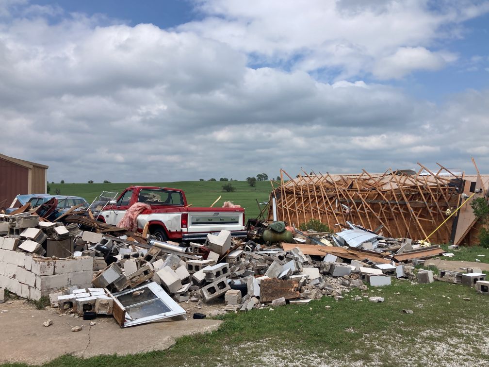
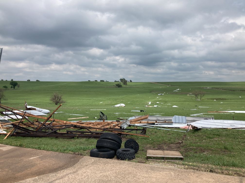
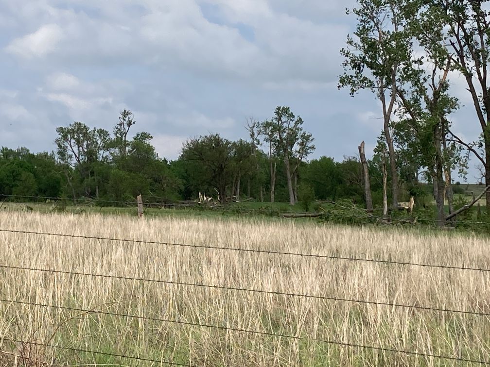
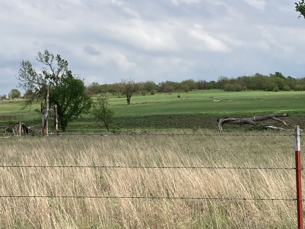
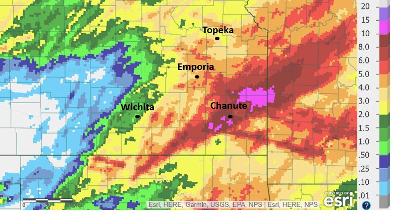
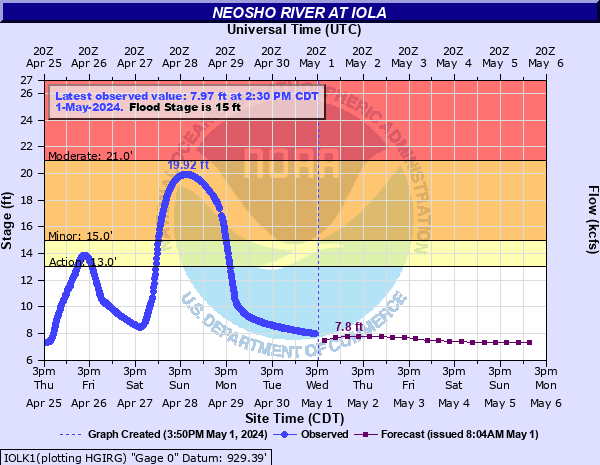
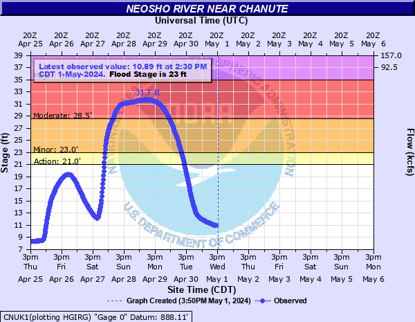
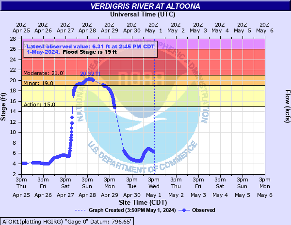
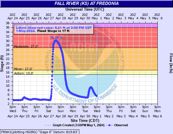
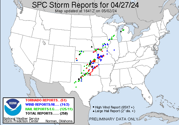
Saturday April 27th was a very volatile severe weather day across Kansas and Oklahoma. The stage was set with an abundance of low level moisture with dewpoints in the mid and upper 60s across the eastern half of Kansas. Low level wind shear increased as the day progressed which resulted in numerous rotating storms that produced several tornadoes across the Flint Hills into southeast Kansas. The strongest tornado was an EF-2, which occurred in Cowley County. Luckily there were no injuries or fatalities reported with these storms. As of May 3rd, we have confirmed 11 tornadoes from the April 27th event. Flooding eventually became a major issue as storms trained across southeast Kansas for several hours. Between April 25th and April 28th, many locations across southeast Kansas picked up between 7 and 10 inches of rainfall which sent the Neosho, Verdigris and Fall rivers into flood. |
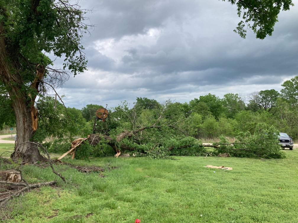
 Tornado damage southwest of Dexter |
Tornadoes:
|
Southwest of Dexter
Track Map 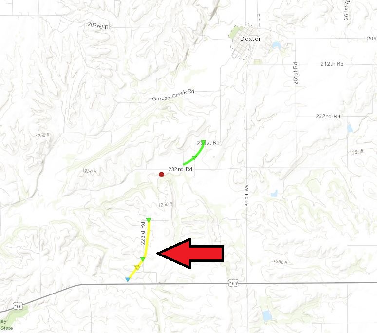 
|
|||||||||||||||||||
|
Southwest of Dexter 2
Track Map 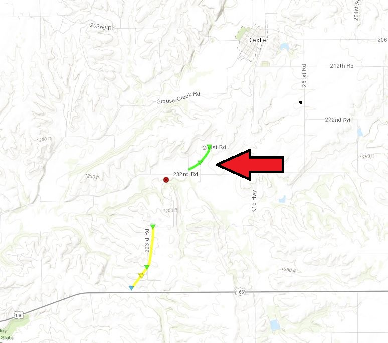
|
||||||||||||||||
|
North of Moline
Track Map 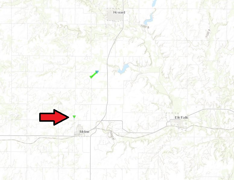 |
||||||||||||||
|
South of Howard
Track Map 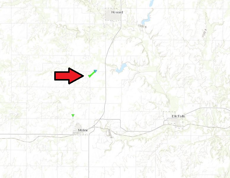 |
||||||||||||||
|
Chautauqua 1
Track Map 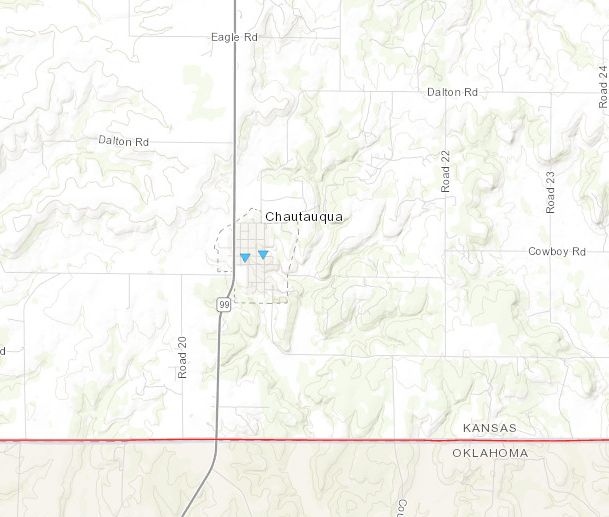
|
|||||||||||||||
|
Chautauqua 2
Track Map
|
|||||||||||||||
The Enhanced Fujita (EF) Scale classifies tornadoes into the following categories:
| EF0 Weak 65-85 mph |
EF1 Moderate 86-110 mph |
EF2 Significant 111-135 mph |
EF3 Severe 136-165 mph |
EF4 Extreme 166-200 mph |
EF5 Catastrophic 200+ mph |
 |
|||||
Flooding
 |
Hydrographs
 |
 |
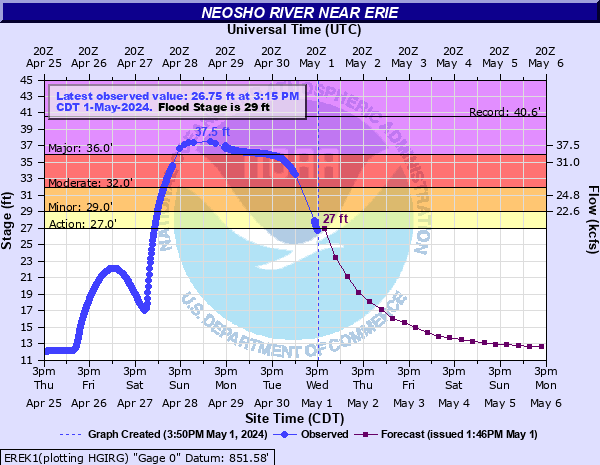 |
| Neosho River at Iola | Neosho River at Chanute | Neosho River at Erie |
 |
 |
|
| Verdigris River at Altoona | Fall River at Fredonia | Caption |
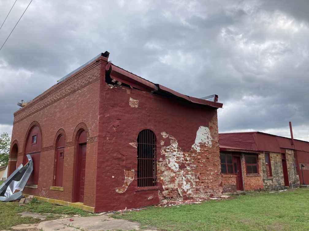
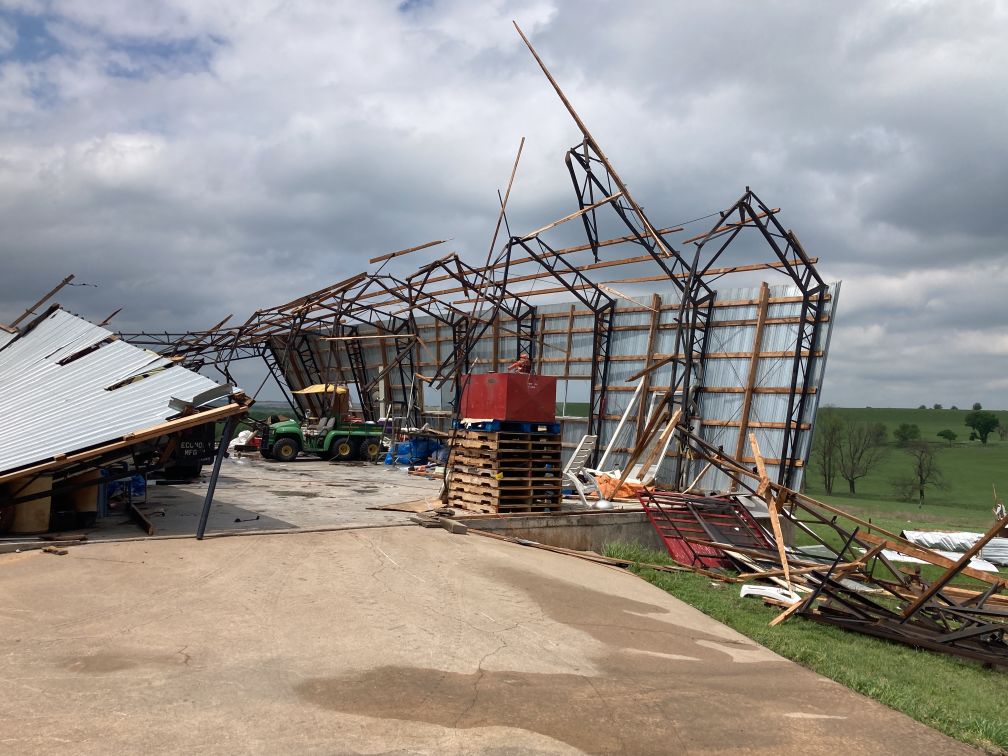
Photos & Video
|
|
|
|
Radar
 |
 |
| Radar animation from around 11 am through 6 pm | Radar animation from around 6 pm through 11:30pm |
|
Reflectivity loop of the supercell that produced the tornado southwest of Dexter. |
Storm relative velocity loop from the supercell that produced the tornado southwest of Dexter |
|
Reflectivity and storm relative velocity data from the supercell that affected Elk County. |
|
Storm Reports
 |
..TIME...   ...EVENT...      ...CITY LOCATION...     ...LAT.LON...
..DATE...   ....MAG....      ..COUNTY LOCATION..ST.. ...SOURCE....
            ..REMARKS..

1215 PM     Hail             1 S South Haven         37.04N 97.40W
04/27/2024  M0.75 Inch       Sumner             KS   Public


0100 PM     Tstm Wnd Gst     Douglass                37.52N 97.01W
04/27/2024  E60 MPH          Butler             KS   Public


0112 PM     Hail             5 NW Winfield           37.29N 97.07W
04/27/2024  E1.00 Inch       Cowley             KS   Trained Spotter


0117 PM     Hail             1 W Douglass            37.52N 97.02W
04/27/2024  M0.75 Inch       Butler             KS   Public


0203 PM     Hail             1 S Leon                37.67N 96.78W
04/27/2024  M0.70 Inch       Butler             KS   Public


0246 PM     Hail             Rosalia                 37.82N 96.62W
04/27/2024  E0.70 Inch       Butler             KS   Public


0303 PM     Hail             Arkansas City           37.07N 97.04W
04/27/2024  M1.00 Inch       Cowley             KS   Emergency Mngr


0316 PM     Funnel Cloud     3 WNW Maple City        37.06N 96.83W
04/27/2024                   Cowley             KS   Storm Chaser

            Report via Spotter Network.

0325 PM     Hail             Caldwell                37.03N 97.62W
04/27/2024  M0.50 Inch       Sumner             KS   Public

            Report from mPING: Half-inch (0.50 in.).

0331 PM     Tornado          3 SSW Dexter            37.14N 96.74W
04/27/2024                   Cowley             KS   Fire Dept/Rescue

            Small tornado reported south of Dexter.

0338 PM     Hail             2 N Dexter              37.21N 96.71W
04/27/2024  M1.00 Inch       Cowley             KS   Trained Spotter


0347 PM     Non-Tstm Wnd Dmg 1 N Marion              38.36N 97.01W
04/27/2024                   Marion             KS   Emergency Mngr

            Power pole down at Highway 56 and Cedar
            Street.

0405 PM     Rain             1 S Arkansas City       37.06N 97.04W
04/27/2024  M1.59 Inch       Cowley             KS   Emergency Mngr

            Rainfall total from recent storm that passed
            through.

0430 PM     Tornado          4 SW Howard             37.43N 96.31W
04/27/2024                   Elk                KS   Trained Spotter

            Reported near the lake north of Moline.

0431 PM     Rain             west of Silverdale      37.06N 96.71W
04/27/2024  M2.21 Inch       Cowley             KS   Trained Spotter

            Rainfall total from storm that recently
            passed throught.

0442 PM     Tornado          1 S Moline              37.35N 96.30W
04/27/2024                   Elk                KS   Storm Chaser

            Multiple brief tornadoes just south of
            Moline. Secondary rotation south of main
            tornado rotation area.

0442 PM     Tornado          1 SW Howard             37.46N 96.28W
04/27/2024                   Elk                KS   Trained Spotter

            Wedge tornado reported heading towards
            Howard.

0445 PM     Tstm Wnd Dmg     1 N Moline              37.38N 96.30W
04/27/2024                   Elk                KS   Storm Chaser

            Trees uprooted.

0454 PM     Tornado          Elk Falls               37.38N 96.19W
04/27/2024                   Elk                KS   Law Enforcement


0454 PM     Tornado          1 NW Longton            37.39N 96.10W
04/27/2024                   Elk                KS   Law Enforcement


0508 PM     Rain             1 West of Silverdale    37.36N 96.32W
04/27/2024  M3.01 Inch       Elk                KS   Cocorahs

            Rainfall total from recent storms.

0527 PM     Hail             1 W New Albany          37.57N 95.96W
04/27/2024  M1.00 Inch       Wilson             KS   Trained Spotter


0531 PM     Hail             2 SW Toronto            37.78N 95.97W
04/27/2024  E1.00 Inch       Greenwood          KS   Fire Dept/Rescue

            Quarter sized hail and 55 mph winds
            reported.

0535 PM     Tornado          3 NE Fredonia           37.56N 95.79W
04/27/2024                   Wilson             KS   Fire Dept/Rescue

            Very brief tornado.

0556 PM     Tornado          5 ENE Benedict          37.64N 95.65W
04/27/2024                   Wilson             KS   Storm Chaser

            DELAYED REPORT Brief tornado touchdown,
            video included via facebook.

0602 PM     Hail             Yates Center            37.88N 95.74W
04/27/2024  E1.00 Inch       Woodson            KS   Storm Chaser


0603 PM     Funnel Cloud     3 SSW Sedan             37.09N 96.21W
04/27/2024                   Chautauqua         KS   Trained Spotter

            Location estimated from radar.

0603 PM     Funnel Cloud     3 W Chautauqua          37.03N 96.22W
04/27/2024                   Chautauqua         KS   Trained Spotter

            Location estimated based on radar.

0607 PM     Flood            1 NE Moline             37.37N 96.29W
04/27/2024                   Elk                KS   Trained Spotter

            Water over road at mile marker 376 U.S.
            Highway 160 west. Just west of U.S. Highway
            99 & 160 west junction.

0620 PM     Flood            Douglass                37.52N 97.01W
04/27/2024                   Butler             KS   Trained Spotter

            Some street flooding in the city.

0630 PM     Flood            3 SE Maple City         37.03N 96.74W
04/27/2024                   Cowley             KS   911 Call Center

            Road closed due to water on road on 201st Rd
            between 292nd Rd and 282nd Rd.

0630 PM     Flood            3 ESE Maple City        37.03N 96.74W
04/27/2024                   Cowley             KS   911 Call Center

            Road closed due to water over road on 201st
            Rd between 292nd Rd and 282nd Rd beginning
            early this evening.

0630 PM     Flood            1 SE Maple City         37.04N 96.77W
04/27/2024                   Cowley             KS   911 Call Center

            Road closed on 201st Rd between 292nd Rd and
            282nd Rd from early this evening.

0646 PM     Flood            1 WSW Elk Falls         37.36N 96.21W
04/27/2024                   Elk                KS   Emergency Mngr

            U.S. Highway 160, one mile west of Elk Falls
            is closed due to water over roadway.

0648 PM     Flood            Iola                    37.93N 95.40W
04/27/2024                   Allen              KS   Emergency Mngr

            Typical roadways in city are starting to
            flood.

0733 PM     Hail             1 ESE Sycamore          37.33N 95.71W
04/27/2024  M1.00 Inch       Montgomery         KS   Trained Spotter


0738 PM     Hail             Yates Center            37.87N 95.74W
04/27/2024  M0.88 Inch       Woodson            KS   Emergency Mngr

            Nickle size hail at Highway 54 and Highway
            75.

0739 PM     Hail             Sycamore                37.33N 95.72W
04/27/2024  M1.75 Inch       Montgomery         KS   Emergency Mngr

            Golf ball size hail.

0741 PM     Hail             Neodesha                37.42N 95.68W
04/27/2024  M1.00 Inch       Wilson             KS   Public


0745 PM     Tornado          3 NE Independence       37.26N 95.68W
04/27/2024                   Montgomery         KS   Public

            Delayed report. Received two separate photos
            of a tornado northeast of Independence. Time
            and location estimated from radar.

0808 PM     Hail             Elk City                37.29N 95.91W
04/27/2024  E0.88 Inch       Montgomery         KS   Fire Dept/Rescue


0810 PM     Flood            Elk City                37.29N 95.91W
04/27/2024                   Montgomery         KS   Emergency Mngr

            Road 5400 and 2100 under water. Heavy rain.

0812 PM     Hail             Elk City                37.29N 95.91W
04/27/2024  E1.00 Inch       Montgomery         KS   Fire Dept/Rescue


0814 PM     Hail             Neodesha                37.42N 95.68W
04/27/2024  M1.00 Inch       Wilson             KS   Trained Spotter


0825 PM     Rain             Neodesha                37.42N 95.68W
04/27/2024  M3.54 Inch       Wilson             KS   Trained Spotter

            Rainfall total since 6:45 pm.

0828 PM     Hail             Independence            37.23N 95.71W
04/27/2024  E0.88 Inch       Montgomery         KS   Law Enforcement


0843 PM     Rain             Arkansas City           37.06N 97.04W
04/27/2024  M3.08 Inch       Cowley             KS   Emergency Mngr

            Rainfall total since 3 pm.

0857 PM     Flood            Neodesha                37.42N 95.68W
04/27/2024                   Wilson             KS   911 Call Center

            Street flooding. Cars flooded with water up
            to hood.

0858 PM     Hail             1 NW Parsons Tri City A 37.35N 95.53W
04/27/2024  E0.88 Inch       Montgomery         KS   Trained Spotter


0858 PM     Tstm Wnd Gst     Strother Field Airport  37.17N 97.04W
04/27/2024  M67 MPH          Cowley             KS   ASOS


0859 PM     Flood            5 ESE Fredonia          37.49N 95.75W
04/27/2024                   Wilson             KS   911 Call Center

            Water over Highway 400 between Fredonia and
            Neodesha. KDOT is expected to close road
            soon.

0859 PM     Hail             7 N Arkansas City       37.17N 97.04W
04/27/2024  M1.00 Inch       Cowley             KS   Emergency Mngr


0927 PM     Tornado          3 NW Neodesha           37.45N 95.72W
04/27/2024                   Wilson             KS   Storm Chaser


0950 PM     Tornado          6 ESE Buxton            37.42N 95.81W
04/27/2024                   Wilson             KS   Public

            Tornado reported on the ground.

0951 PM     Flood            Moline                  37.36N 96.31W
04/27/2024                   Elk                KS   Public

            Intersection of Highway 160 and Road 13
            closed due to water over road.

0954 PM     Flash Flood      3 WSW Elk Falls         37.36N 96.25W
04/27/2024                   Elk                KS   Public

            Road closed near Highway 160 and Dove Road
            due to water over road.

1000 PM     Flash Flood      5 ESE Longton           37.34N 96.01W
04/27/2024                   Elk                KS   911 Call Center

            Roadway closed due to water over road by Oak
            Valley along Highway 160 and mile marker
            382.

1001 PM     Hail             4 N Manchester          37.05N 98.04W
04/27/2024  M0.75 Inch       Harper             KS   Public

            Report from mPING: Dime (0.75 in.).

1012 PM     Hail             1.5 E Petrolia          37.75N 95.44W
04/27/2024  M1.00 Inch       Allen              KS   Law Enforcement
Environment
 |
 |
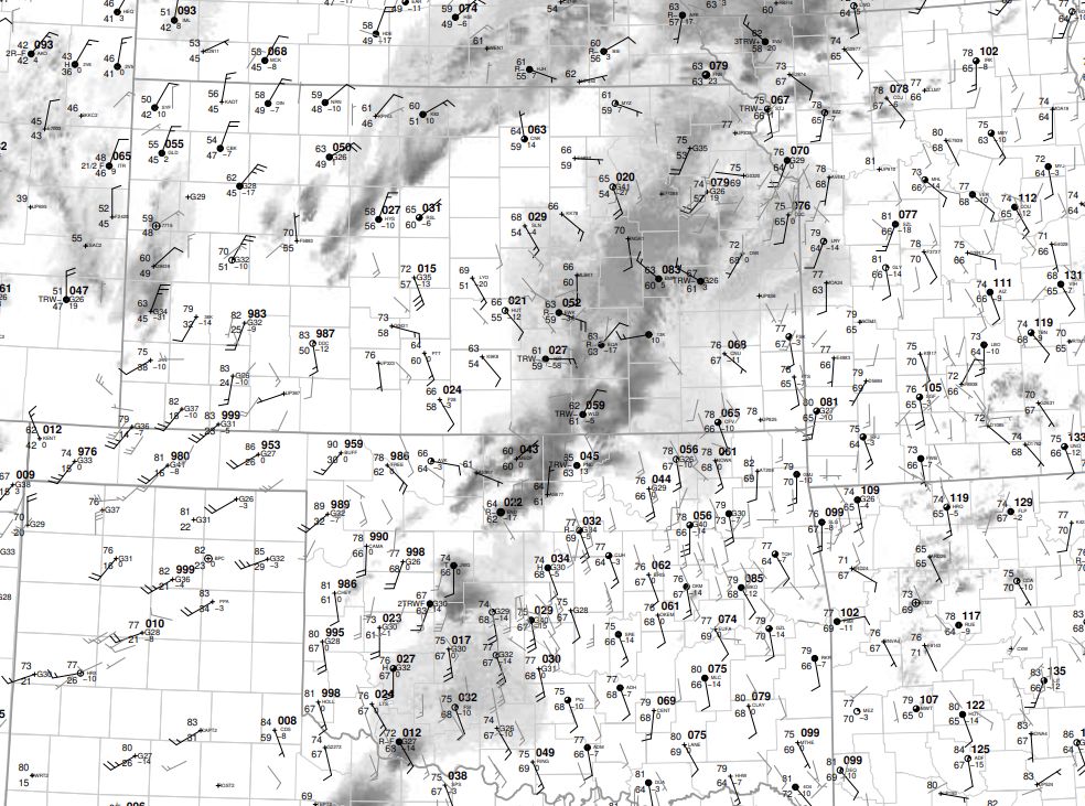 |
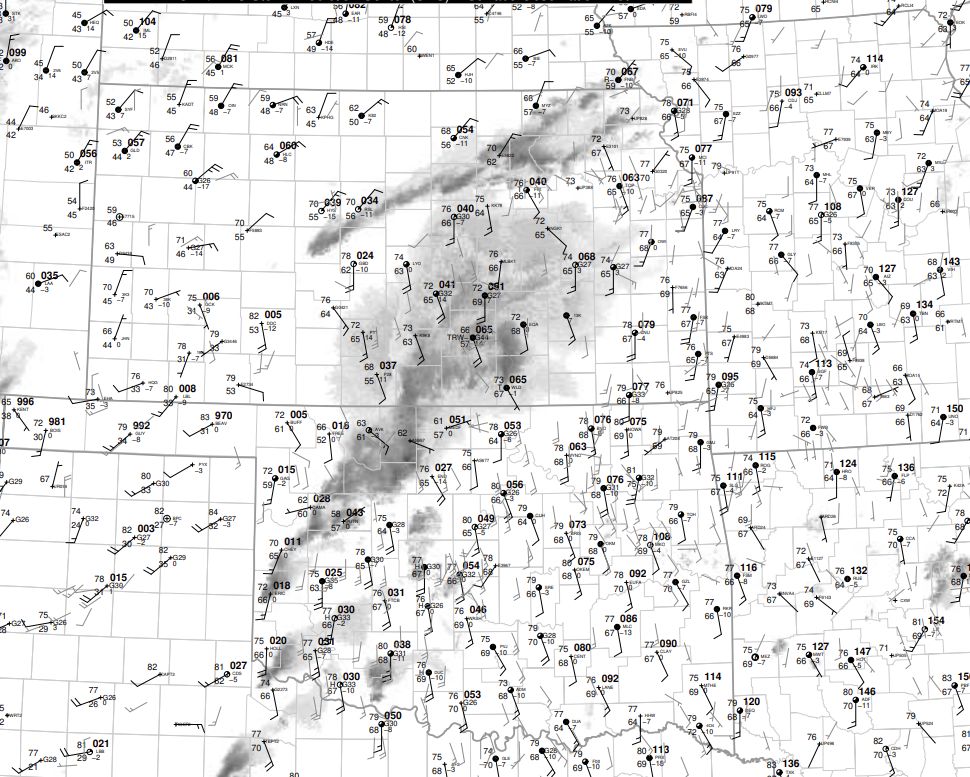
| 15z Surface map | 18z Surface map | 21z Surface map |
 |
 |
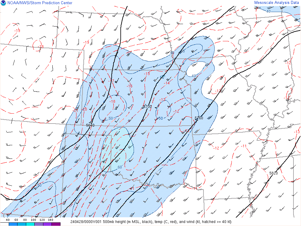 |
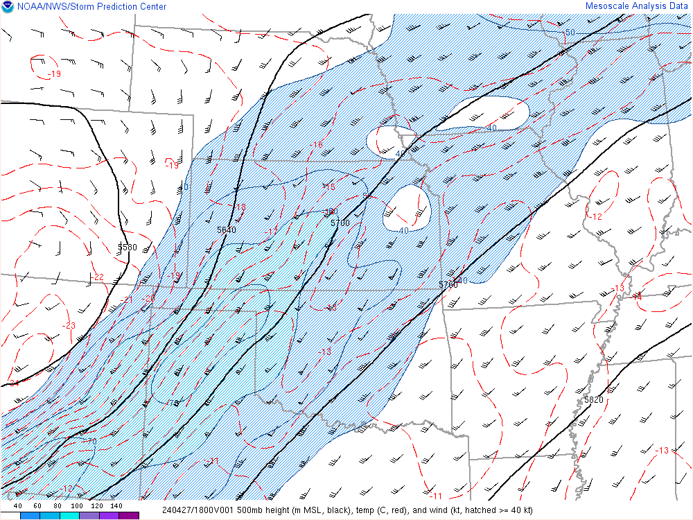
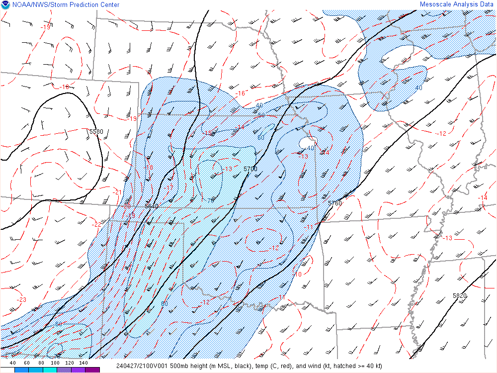
| 18z 500mb | 21z 500mb | 00z 500mb |
 |
 |
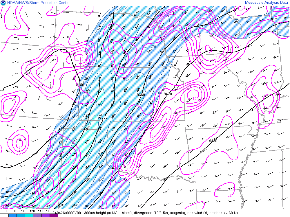 |
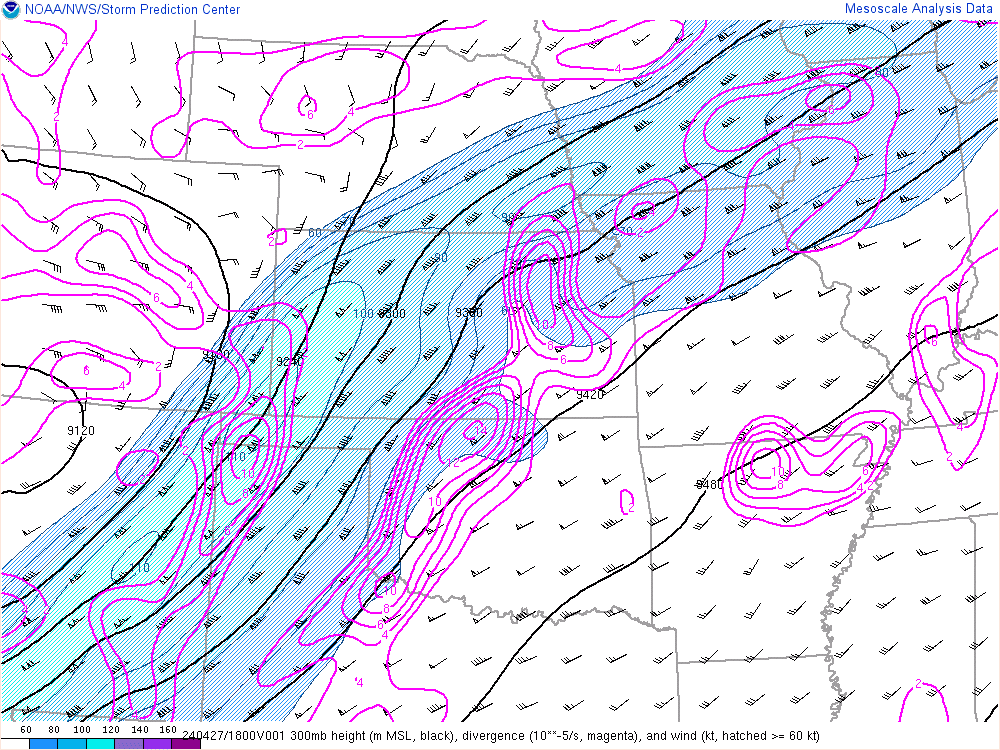
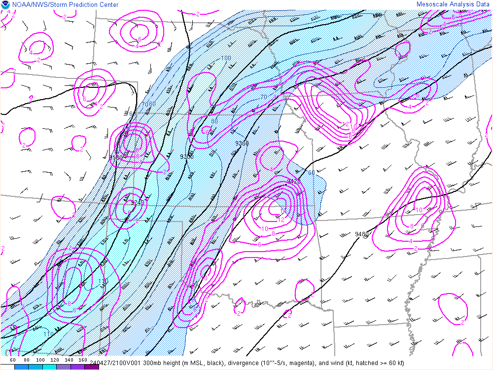
| 18z 300mb | 21z 300mb | 00z 300mb |
 |
 |
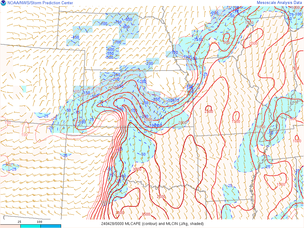 |
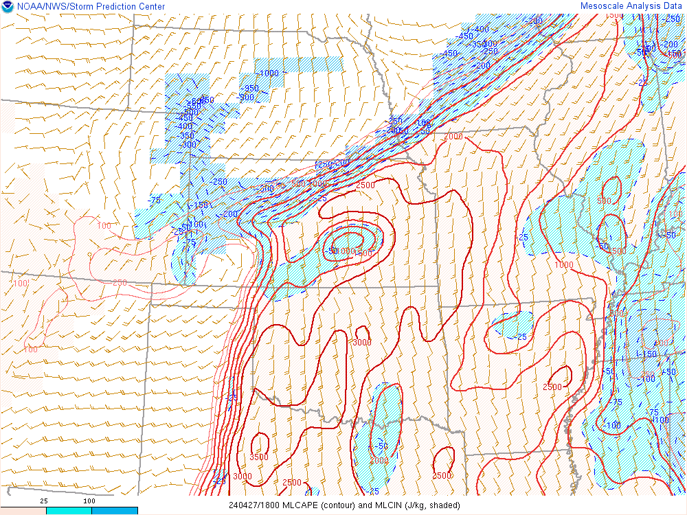
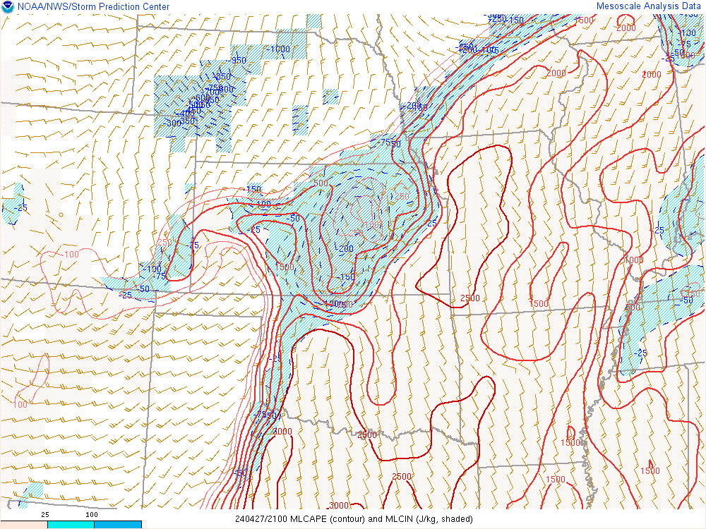
| 18z ML CAPE | 21z ML CAPE | 00z ML CAPE |
 |
 |
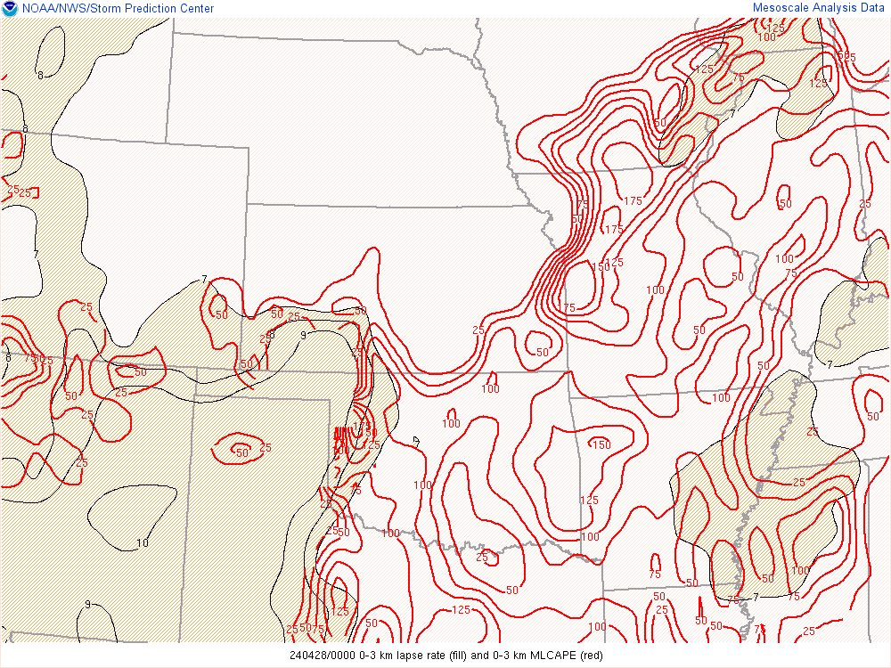 |
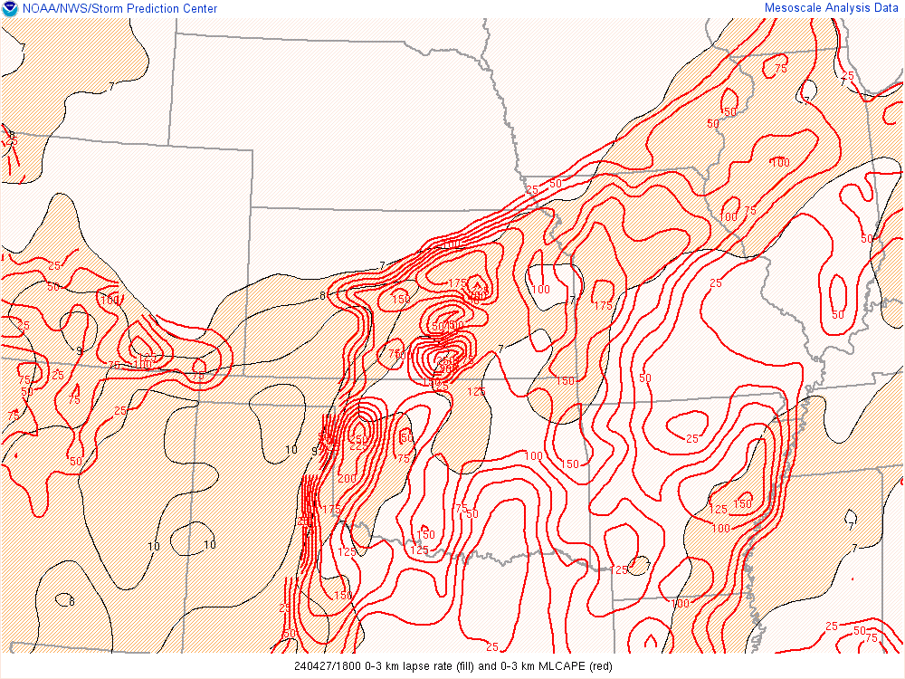
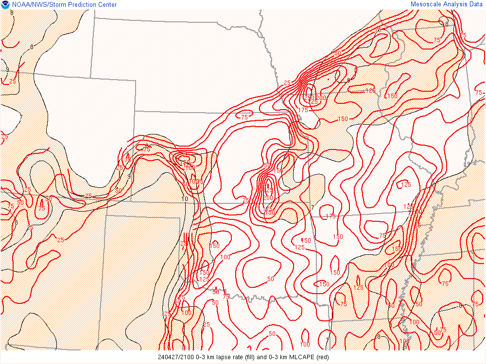
| 18z 0-3km CAPE | 21z 0-3km CAPE | 00z 0-3km CAPE |
.gif) |
 |
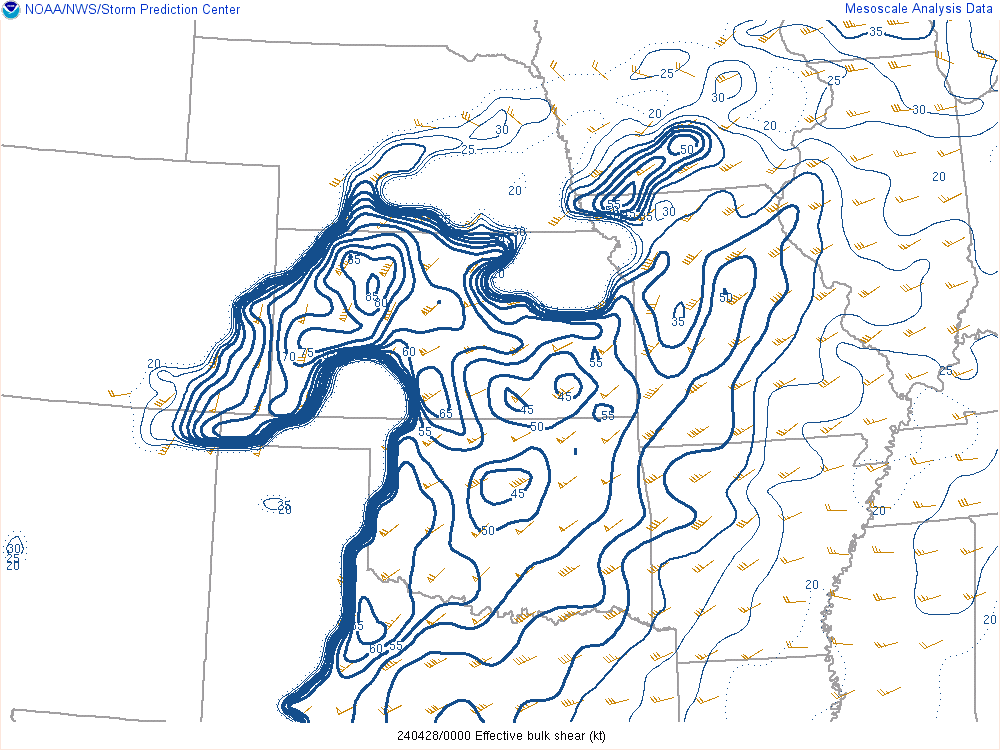 |
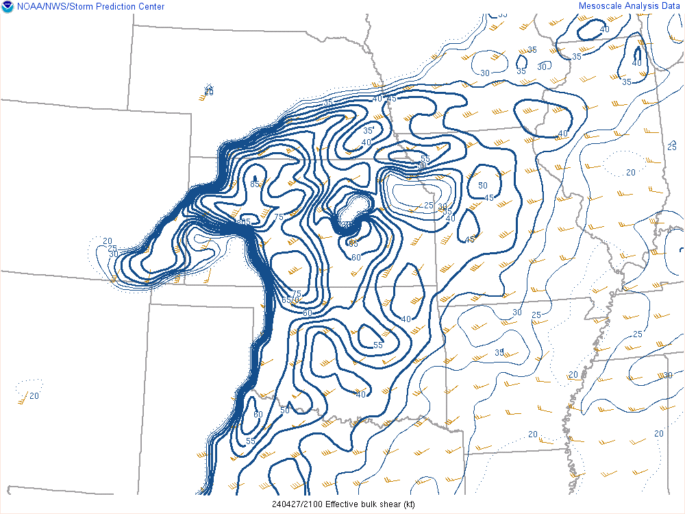
| 18z Effective deep shear | 21z Effective deep shear | 00z Effective deep shear |
 |
 |
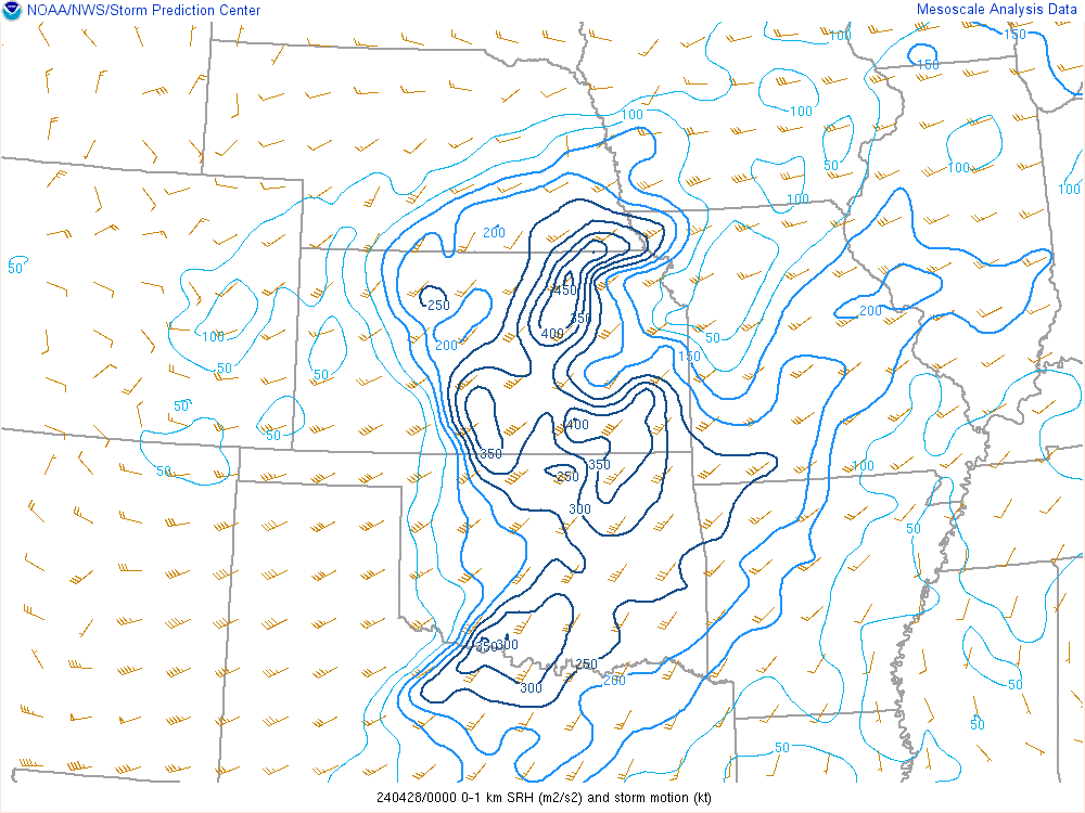 |
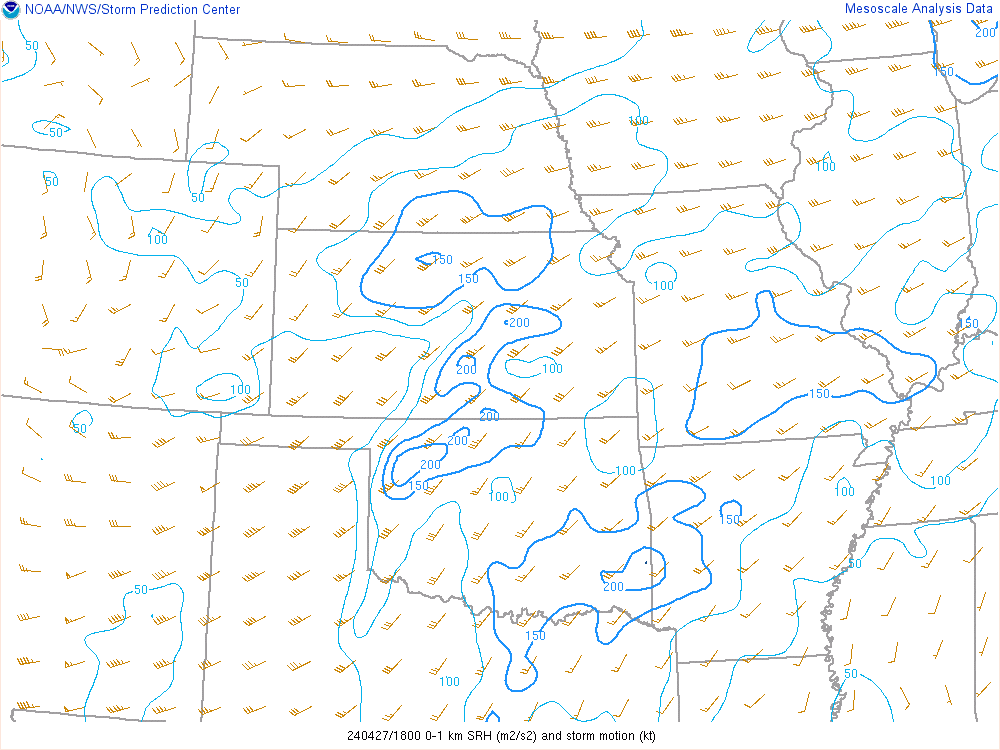
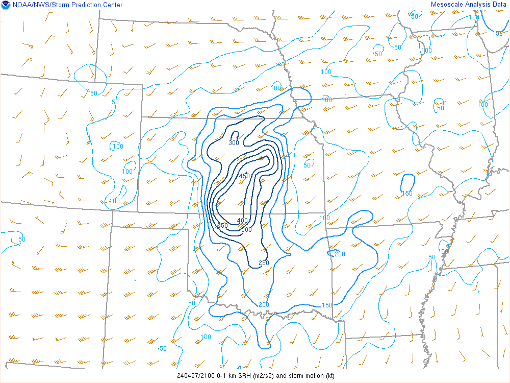
| 18z 0-1km SRH | 21z 0-1km SRH | 00z 0-1km SRH |
 |
 |
 |
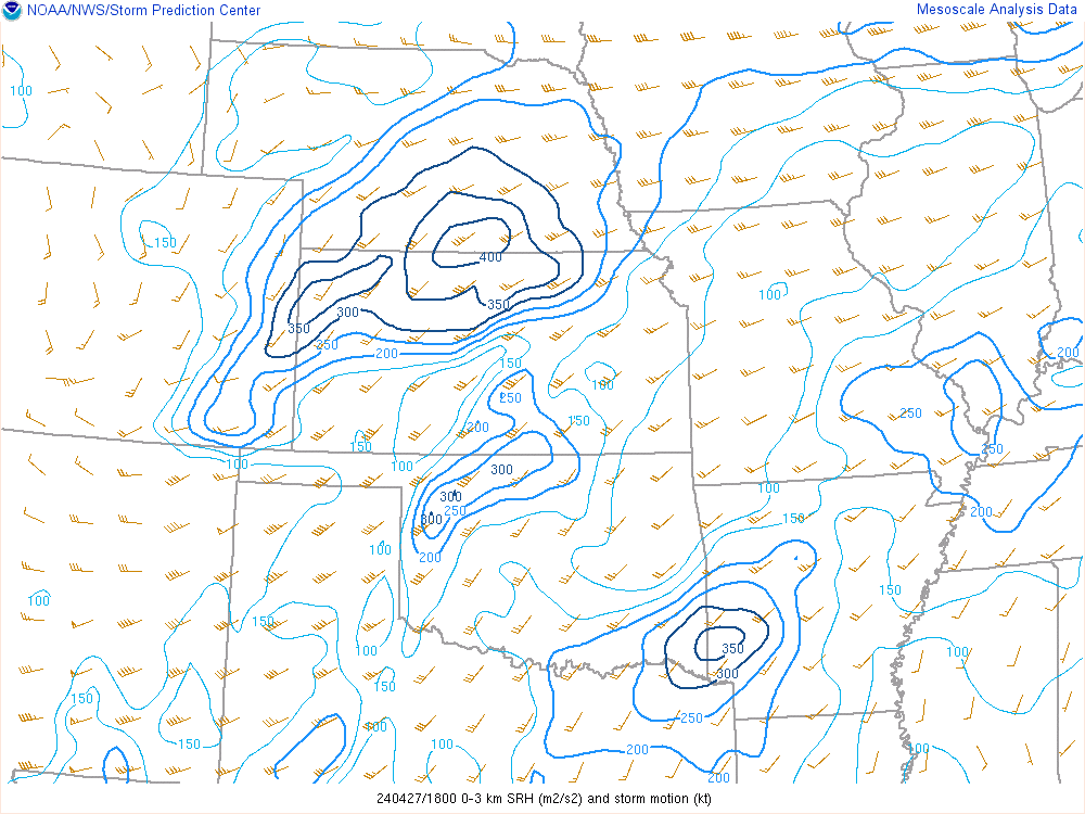
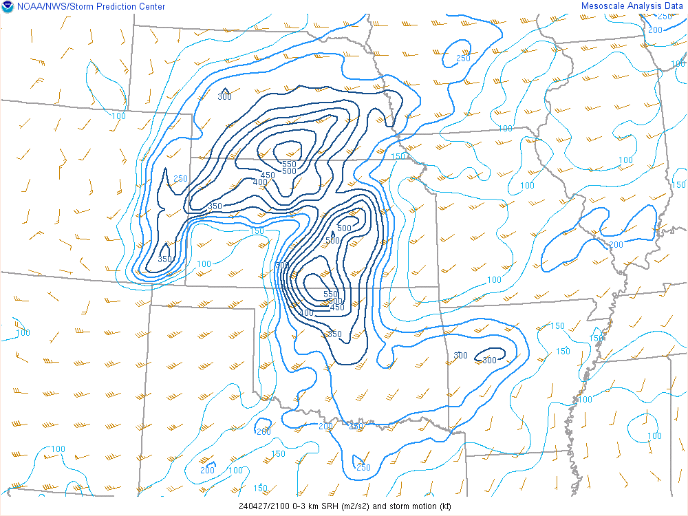
| 18z 0-3km SRH | 21z 0-3km SRH | 00z 0-3km SRH |
 |
 |
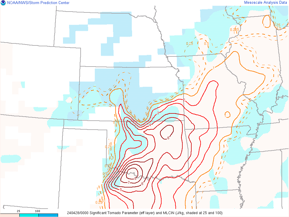 |
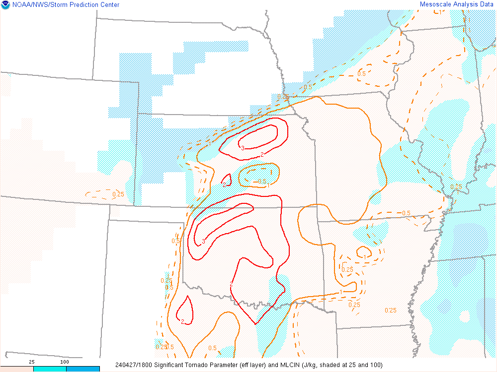
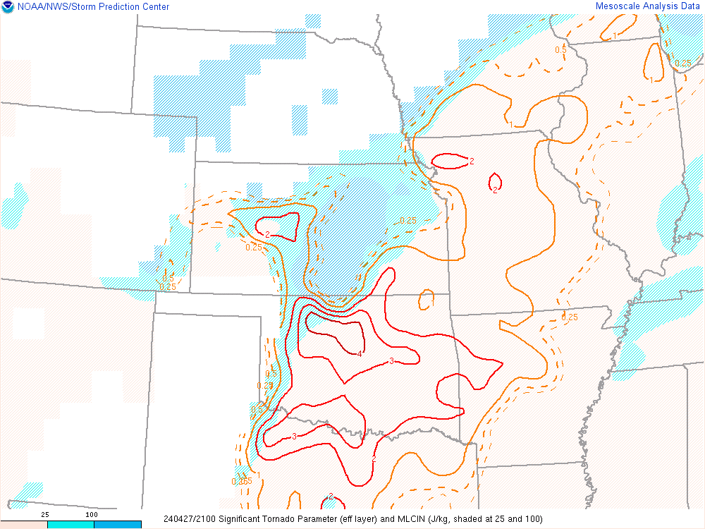
| 18z STP | 21z STP | 00z STP |
 |
Media use of NWS Web News Stories is encouraged! Please acknowledge the NWS as the source of any news information accessed from this site. |
|