Overview
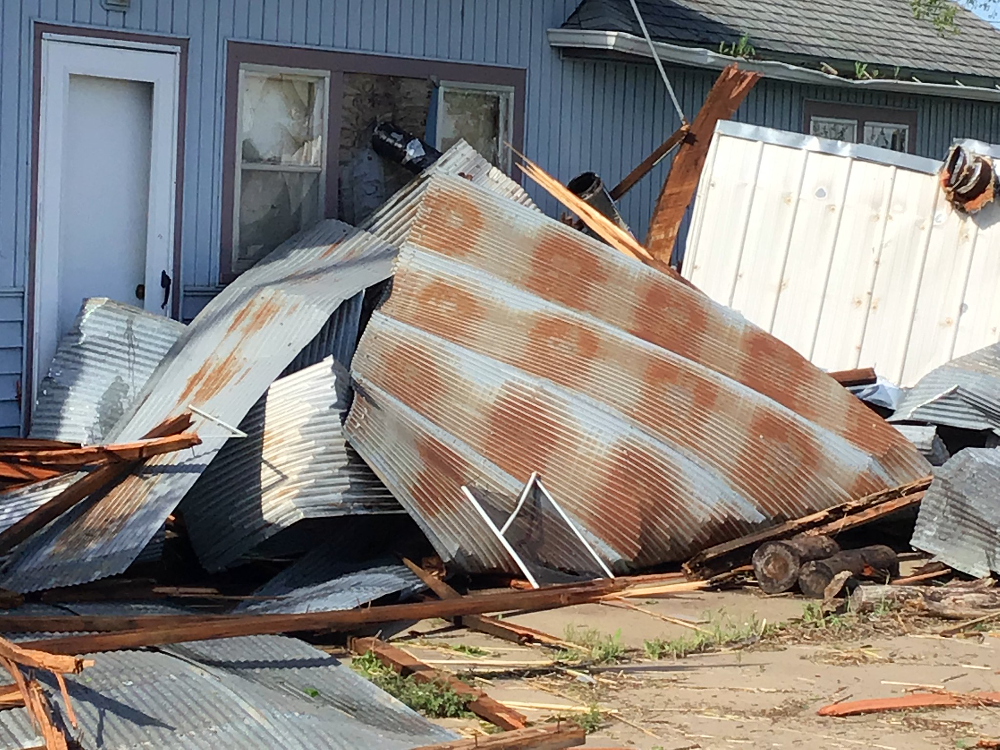
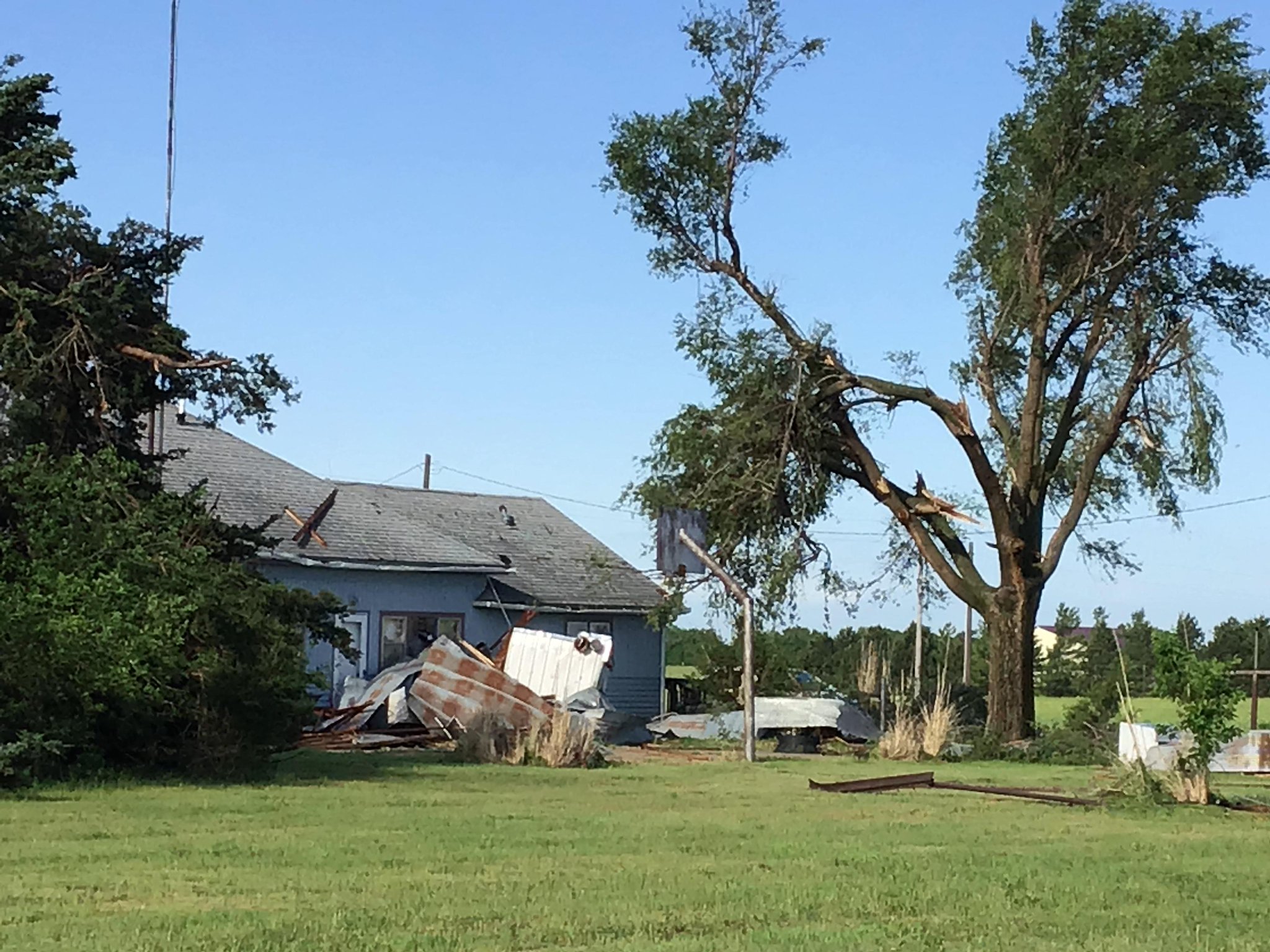
Storms developed during the late afternoon hours on Wednesday May 26th over Central Kansas near a warm front. A very moist and unstable air mass was in place which allowed storms to rapidly become severe, producing hail up to baseball size along with a few brief tornadoes. The strongest tornado caused some damage across far northern Rice county. These same storms also produced very heavy rainfall which lead to some flooding.Tornadoes:
|
Tornado - 3 sw of Geneseo
Track Map 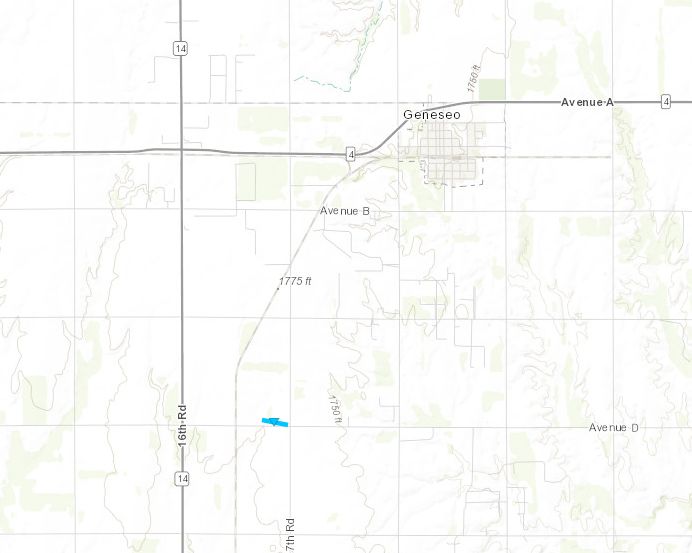 
|
||||||||||||||||||
|
Tornado - 8 N Claflin
Track Map 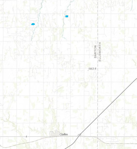
Downloadable KMZ File |
||||||||||||||||
|
Tornado - 7 NW Holyrood
Track Map
Downloadable KMZ File |
||||||||||||||||
The Enhanced Fujita (EF) Scale classifies tornadoes into the following categories:
| EF0 Weak 65-85 mph |
EF1 Moderate 86-110 mph |
EF2 Significant 111-135 mph |
EF3 Severe 136-165 mph |
EF4 Extreme 166-200 mph |
EF5 Catastrophic 200+ mph |
 |
|||||
Photos & Video
|
|
|
|
|
|
|
|
|
|
|
here |
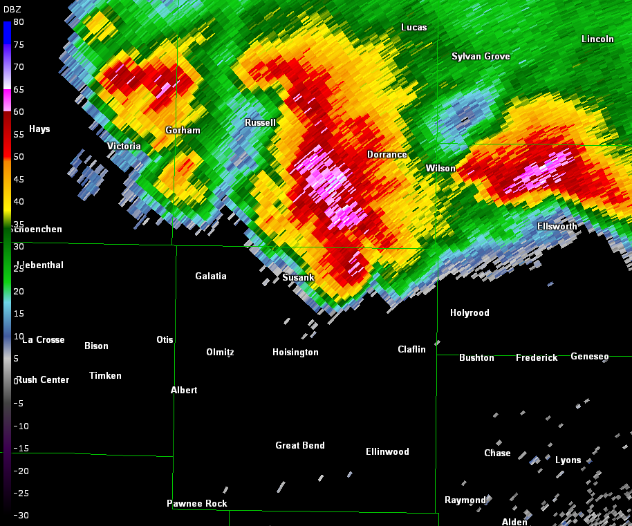
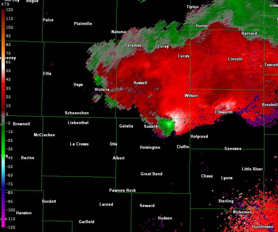
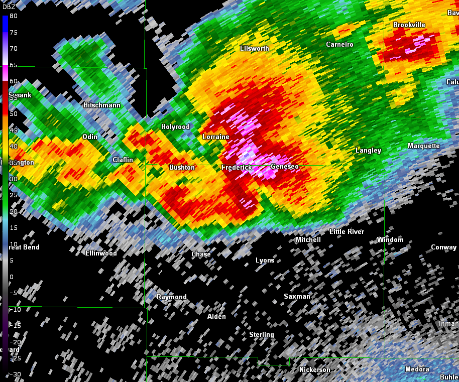
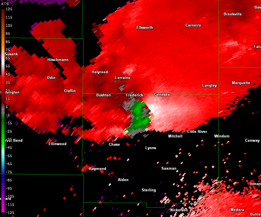
Radar
|
Reflectivity image from 448 pm |
Storm relative velocity image from 448 pm |
|
Reflectivity image from 649pm |
Storm relative velocity image from 649pm |
 |
Storm Reports
084
NWUS53 KICT 270939
LSRICT

PRELIMINARY LOCAL STORM REPORT...SUMMARY
NATIONAL WEATHER SERVICE WICHITA KS
439 AM CDT THU MAY 27 2021

..TIME...   ...EVENT...      ...CITY LOCATION...     ...LAT.LON...
..DATE...   ....MAG....      ..COUNTY LOCATION..ST.. ...SOURCE....
            ..REMARKS..

0309 PM     FUNNEL CLOUD     7 ENE SUSANK            38.68N 98.65W
05/26/2021                   BARTON             KS   TRAINED SPOTTER

            STORM SPOTTER REPORTED A WELL DEFINED WALL
            CLOUD.

0350 PM     HAIL             3 S GORHAM              38.84N 99.02W
05/26/2021  E1.00 INCH       RUSSELL            KS   EMERGENCY MNGR


0404 PM     TSTM WND GST     3 SE RUSSELL            38.86N 98.81W
05/26/2021  E70 MPH          RUSSELL            KS   EMERGENCY MNGR

            60 TO 70 MPH WINDS.

0406 PM     TSTM WND GST     2 SE GORHAM             38.86N 99.00W
05/26/2021  E60 MPH          RUSSELL            KS   EMERGENCY MNGR


0424 PM     HAIL             5 SW RUSSELL            38.84N 98.92W
05/26/2021  E1.25 INCH       RUSSELL            KS   EMERGENCY MNGR

            60 MPH WINDS WERE ALSO REPORTED ALONG WITH
            AN UPROOTED TREE.

0425 PM     TSTM WND DMG     1 N RUSSELL             38.91N 98.86W
05/26/2021                   RUSSELL            KS   TRAINED SPOTTER

            40 FOOT TALL, 3FT WIDE ELM TREE BLOWN OVER.
            DELAYED REPORT. TIME ESTIMATED BASED ON
            RADAR.

0428 PM     TSTM WND GST     3 S RUSSELL             38.84N 98.85W
05/26/2021  E60 MPH          RUSSELL            KS   EMERGENCY MNGR

            DIME SIZED HAIL ALSO REPORTED ALONG WITH
            VERY HEAVY RAIN.

0439 PM     HAIL             RUSSELL                 38.89N 98.85W
05/26/2021  E1.50 INCH       RUSSELL            KS   FIRE DEPT/RESCUE


0445 PM     HAIL             RUSSELL                 38.89N 98.85W
05/26/2021  M1.75 INCH       RUSSELL            KS   PUBLIC

            VIA SOCIAL MEDIA PIC.

0454 PM     TORNADO          6 NNW CLAFLIN           38.60N 98.58W
05/26/2021                   BARTON             KS   TRAINED SPOTTER

            VERY BRIEF TOUCHDOWN.

0510 PM     TORNADO          8 N CLAFLIN             38.64N 98.54W
05/26/2021                   BARTON             KS   LAW ENFORCEMENT

            BRIEF TOUCHDOWN FOR LESS THAN ONE MINUTE.

0543 PM     FLOOD            4 W RUSSELL             38.89N 98.93W
05/26/2021                   RUSSELL            KS   EMERGENCY MNGR

            FLOODING ON OLD HWY 40.

0600 PM     HAIL             KANOPOLIS STATE PARK    38.65N 98.03W
05/26/2021  E1.00 INCH       ELLSWORTH          KS   LAW ENFORCEMENT


0605 PM     HAIL             6 NNE KANOPOLIS         38.78N 98.10W
05/26/2021  E1.00 INCH       ELLSWORTH          KS   TRAINED SPOTTER

            1.3 INCHES OF RAIN AND 40 MPH WINDS WITH THE
            STORM AS IT PASSED.

0615 PM     HAIL             8 NE KANOPOLIS          38.78N 98.04W
05/26/2021  E0.70 INCH       ELLSWORTH          KS   TRAINED SPOTTER

            OCCASIONAL DIME HAIL WITH VERY HEAVY RAIN.

0622 PM     FUNNEL CLOUD     4 SW CLAFLIN            38.48N 98.59W
05/26/2021                   BARTON             KS   TRAINED SPOTTER


0624 PM     HAIL             HOLYROOD                38.59N 98.41W
05/26/2021  E1.50 INCH       ELLSWORTH          KS   PUBLIC


0635 PM     TSTM WND DMG     HOLYROOD                38.59N 98.41W
05/26/2021                   ELLSWORTH          KS   EMERGENCY MNGR

            SEMI TRUCK BLOWN OVER ON HWY 156.

0640 PM     FUNNEL CLOUD     3 SE HOLYROOD           38.56N 98.37W
05/26/2021                   ELLSWORTH          KS   STORM CHASER

            BEST ESTIMATED LOCATION BASED ON THE REPORT
            AND RADAR DATA.

0643 PM     HAIL             FREDERICK               38.51N 98.27W
05/26/2021  E1.00 INCH       RICE               KS   TRAINED SPOTTER


0654 PM     HAIL             WNW GENESEO             38.52N 98.16W
05/26/2021  E1.25 INCH       RICE               KS   TRAINED SPOTTER


0654 PM     HAIL             4 N LYONS               38.40N 98.20W
05/26/2021  E1.75 INCH       RICE               KS   TRAINED SPOTTER

            VERY HEAVY RAIN WITH THE HAIL.

0656 PM     HAIL             FREDERICK               38.51N 98.27W
05/26/2021  M1.75 INCH       RICE               KS   EMERGENCY MNGR


0656 PM     TSTM WND GST     2 SW SALINA             38.79N 97.65W
05/26/2021  M60 MPH          SALINE             KS   ASOS


0657 PM     HAIL             4 SW GENESEO            38.48N 98.20W
05/26/2021  M1.75 INCH       RICE               KS   EMERGENCY MNGR


0702 PM     TSTM WND DMG     1 ESE SALINA            38.81N 97.60W
05/26/2021                   SALINE             KS   EMERGENCY MNGR

            POWER LINES DOWN IN THE CITY OF SALINA.

0703 PM     FLOOD            5 NW RUSSELL            38.94N 98.92W
05/26/2021                   RUSSELL            KS   EMERGENCY MNGR

            WATER WAS REPORTED OVER THE ROAD.

0705 PM     HAIL             WNW GENESEO             38.52N 98.16W
05/26/2021  E2.00 INCH       RICE               KS   TRAINED SPOTTER


0706 PM     HAIL             1 W GENESEO             38.52N 98.17W
05/26/2021  E1.50 INCH       RICE               KS   TRAINED SPOTTER


0715 PM     HAIL             1 N GENESEO             38.53N 98.15W
05/26/2021  E1.25 INCH       ELLSWORTH          KS   TRAINED SPOTTER


0723 PM     HAIL             GENESEO                 38.52N 98.15W
05/26/2021  E2.00 INCH       RICE               KS   TRAINED SPOTTER

            RELAYED VIA KWCH.

0725 PM     HAIL             WNW GENESEO             38.52N 98.16W
05/26/2021  E1.00 INCH       RICE               KS   TRAINED SPOTTER


0733 PM     TSTM WND DMG     SALINA                  38.82N 97.62W
05/26/2021                   SALINE             KS   EMERGENCY MNGR

            A TREE THAT WAS BLOWN DOWN TOOK OUT POWER IN
            THE NORTH PART OF TOWN.

0757 PM     FLOOD            GENESEO                 38.51N 98.16W
05/26/2021                   RICE               KS   LAW ENFORCEMENT

            MAIN STREET HAS IS COVERED WITH WATER AND
            SOME OF THE CREEKS JUST SOUTH OF TOWN ARE
            OUT OF THEIR BANKS.

0807 PM     TSTM WND DMG     3 NE SALINA             38.85N 97.57W
05/26/2021                   SALINE             KS   TRAINED SPOTTER

            5 INCH TREE BRANCHES REPORTED BLOWN DOWN.

0843 PM     HAIL             MCPHERSON               38.37N 97.66W
05/26/2021  E1.75 INCH       MCPHERSON          KS   TRAINED SPOTTER


0847 PM     HAIL             1 NNE MCPHERSON         38.38N 97.66W
05/26/2021  E1.75 INCH       MCPHERSON          KS   LAW ENFORCEMENT

            QUARTER TO GOLF BALL SIZED HAIL AT MCPHERSON
            HIGH SCHOOL.

0850 PM     HAIL             MCPHERSON               38.37N 97.67W
05/26/2021  E2.75 INCH       MCPHERSON          KS   PUBLIC

            DELAYED REPORT VIA SOCIAL MEDIA.

0907 PM     HAIL             INMAN                   38.23N 97.77W
05/26/2021  E1.00 INCH       MCPHERSON          KS   TRAINED SPOTTER


0920 PM     HAIL             3 W GALVA               38.37N 97.60W
05/26/2021  M1.25 INCH       MCPHERSON          KS   TRAINED SPOTTER


0930 PM     TSTM WND GST     5 NW MOUNDRIDGE         38.26N 97.58W
05/26/2021  E60 MPH          MCPHERSON          KS   TRAINED SPOTTER

            ALSO REPORTED DIME SIZE HAIL.

0953 PM     FLOOD            5.5 S MCPHERSON         38.29N 97.66W
05/26/2021                   MCPHERSON          KS   STORM CHASER

            FLOODING ON COUNTY ROADS. DITCHES ARE
            RUNNING FULL.

1140 PM     TSTM WND GST     5 NW CLEARWATER         37.56N 97.55W
05/26/2021  M62 MPH          SEDGWICK           KS   PUBLIC


1201 AM     TSTM WND DMG     3 SW MULVANE            37.45N 97.28W
05/27/2021                   SUMNER             KS   PUBLIC

            DELAYED REPORT: NUMEROUS LARGE TREE LIMBS
            DOWN.

1201 AM     FLASH FLOOD      MCPHERSON               38.37N 97.67W
05/27/2021                   MCPHERSON          KS   PUBLIC

            MULTIPLE NEIGHBORHOODS IN MCPHERSON
            SURROUNDED BY WATER.

1208 AM     TSTM WND DMG     4 WSW LINCOLNVILLE      38.48N 97.04W
05/27/2021                   MARION             KS   LAW ENFORCEMENT

            DELAYED REPORT: LARGE TREE DOWN OVER THE
            ROAD.

1215 AM     TSTM WND GST     1 N EAST WICHITA        37.70N 97.26W
05/27/2021  E60 MPH          SEDGWICK           KS   PUBLIC


1220 AM     TSTM WND DMG     6 WNW LOST SPRINGS      38.60N 97.06W
05/27/2021                   MARION             KS   EMERGENCY MNGR

            DELAYED REPORT: TREES ACROSS ROADS AND WIND
            DAMAGE TO HOMES.

1225 AM     TSTM WND DMG     7 ESE UDALL             37.36N 97.00W
05/27/2021                   COWLEY             KS   EMERGENCY MNGR

            DELAYED REPORT: 12-14 LIVE TREE SNAPPED NEAR
            THE BASE.

1231 AM     TSTM WND DMG     5 E EL DORADO           37.83N 96.77W
05/27/2021                   BUTLER             KS   PUBLIC

            1-INCH TREE LIMBS BROKEN; SHINGLES BLOWN
            OFF.

1250 AM     TSTM WND DMG     EL DORADO               37.82N 96.86W
05/27/2021                   BUTLER             KS   PUBLIC

            DELAYED REPORT: VERY LARGE TREE (5-6 FT IN
            DIAMETER) DOWN OVER THE ROAD. SEVERAL OTHER
            LIMBS AND BRANCHES OF 14+ INCHES IN DIAMETER
            BROKEN IN THE AREA.

1255 AM     TSTM WND DMG     1 ENE EL DORADO         37.82N 96.85W
05/27/2021                   BUTLER             KS   PUBLIC

            6-INCH TREE LIMBS DOWN, E60.

0300 AM     FLASH FLOOD      5 W LOST SPRINGS        38.57N 97.05W
05/27/2021                   MARION             KS   LAW ENFORCEMENT

            DELAYED REPORT: WATER IS STILL RISING,
            NUMEROUS ROADWAYS UNDER WATER. DIFFICULTY
            GETTING AROUND TO ASSESS ANY STORM DAMAGE.
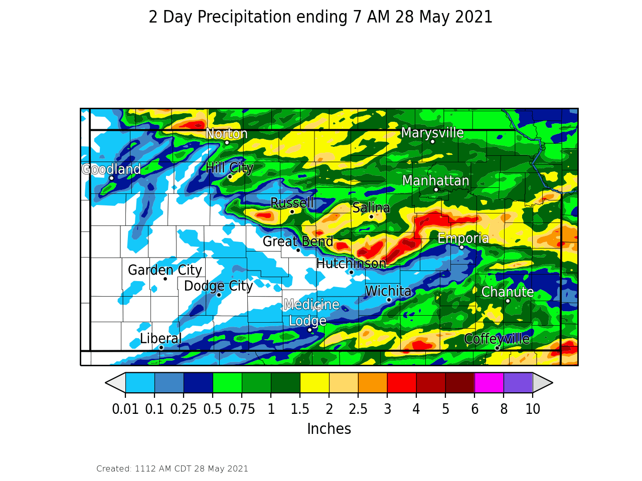
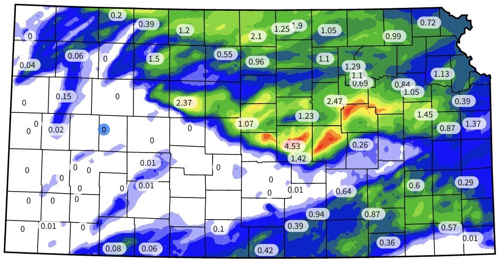
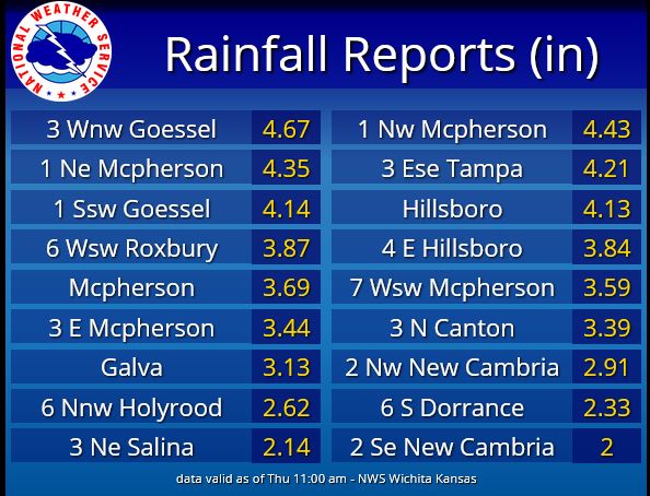
Rain Reports
|
May 26th-27th rainfall amounts |
May 26th rainfall amounts from the Kansas Mesonet (@ksmesonet) |
|
 |
||
 |
Media use of NWS Web News Stories is encouraged! Please acknowledge the NWS as the source of any news information accessed from this site. |
|