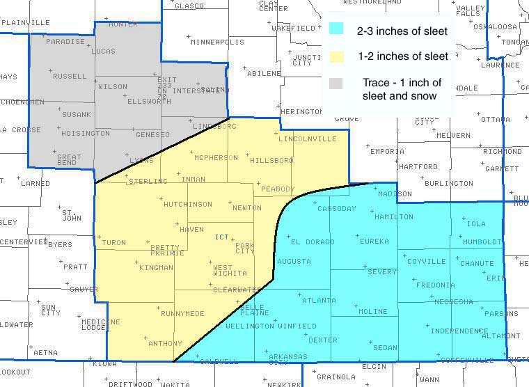
While the first winter storm of 2007 did not produce significant snowfall amounts, it did bring unusually large amounts of sleet. The stage was set for this event as very cold arctic air filtered into the area during the early morning hours of Friday January 12th. Once this cold air was firmly in place, a series of upper level disturbances tracked out of the desert southwest and into the southern plains. The first round of wintry precipitation started Friday over Southeast Kansas with the remainder of the area getting in on the action Saturday January 13 and Sunday January 14th.
Even though it was plenty cold at the surface for snow, a layer of warm air aloft allowed the ice crystals to melt on the way down, and then refreeze right before hitting the ground. This is why the majority of the precipitation during this event fell as sleet. Southeast Kansas was hardest hit with some locations picking-up 3 inches of sleet.
 |
Below are reported sleet amounts on Sunday afternoon(Jan 14th):
SLEET AND FREEZING RAIN REPORTS LISTED BY AMOUNT

 INCHES  LOCATION                 ST  COUNTY           TIME
 ------  -----------------------  --  --------------   -------
  3.50   WELLINGTON               KS  SUMNER           0130 PM
                 STORM TOTAL SLEET ACCUMULATION.
  3.00   5 SW PARSONS             KS  LABETTE          0405 PM
  3.00   2 S IOLA                 KS  ALLEN            0355 PM
  3.00   EUREKA                   KS  GREENWOOD        0310 PM
  2.50   14 NE INDEPENDENCE       KS  MONTGOMERY       0255 PM
  2.50   ARKANSAS CITY            KS  COWLEY           0150 PM
                 STORM TOTAL SLEET ACCUMULATION.
  2.25   EL DORADO                KS  BUTLER           0105 PM
                 NEW SLEET ACCUMULATION TODAY 1.50 INCHES.
                 TOTAL DEPTH ON GROUND 2.25 INCHES.
  2.00   MOUNDRIDGE               KS  MCPHERSON        0400 PM
  2.00   ERIE                     KS  NEOSHO           0355 PM
  2.00   INDEPENDENCE             KS  MONTGOMERY       0350 PM
  2.00   FREDONIA                 KS  WILSON           0345 PM
  2.00   YATES CENTER             KS  WOODSON          0325 PM
  2.00   SEDAN                    KS  CHAUTAUQUA       0315 PM
  2.00   COFFEYVILLE              KS  MONTGOMERY       0230 PM
                 STORM TOTAL SLEET ACCUMULATION AROUND TWO
                 INCHES.
  1.50   NEWTON                   KS  HARVEY           0145 PM
                 STORM TOTAL SLEET ACCUMULATION 1 TO 1.5
                 INCHES.
  1.25   ELK FALLS                KS  ELK              0300 PM
  1.25   HUTCHINSON               KS  RENO             0152 PM
                 NEW SLEET TODAY 1.0 INCH AND TOTAL DEPTH 1.25
                 INCHES.
  1.00   WEST WICHITA             KS  SEDGWICK         0400 PM
                 DEPTH OF SLEET AT THE NWS WICHITA WAS 1 INCH.
  1.00   ELLSWORTH                KS  ELLSWORTH        0120 PM
                 STORM TOTAL SLEET ACCUMULATION AROUND ONE
                 INCH.
  1.00   ANTHONY                  KS  HARPER           0115 PM
                 STORM TOTAL SLEET ACCUMULATION AROUND ONE
                 INCH.
  1.00   LYONS                    KS  RICE             0110 PM
                 STORM TOTAL SLEET ACCUMULATION AROUND ONE
                 INCH.
  0.75   SALINA                   KS  SALINE           0115 PM
                 STORM TOTAL SLEET ACCUMULATION AROUND THREE
                 QUARTERS OF AN INCH.